
Passport
-
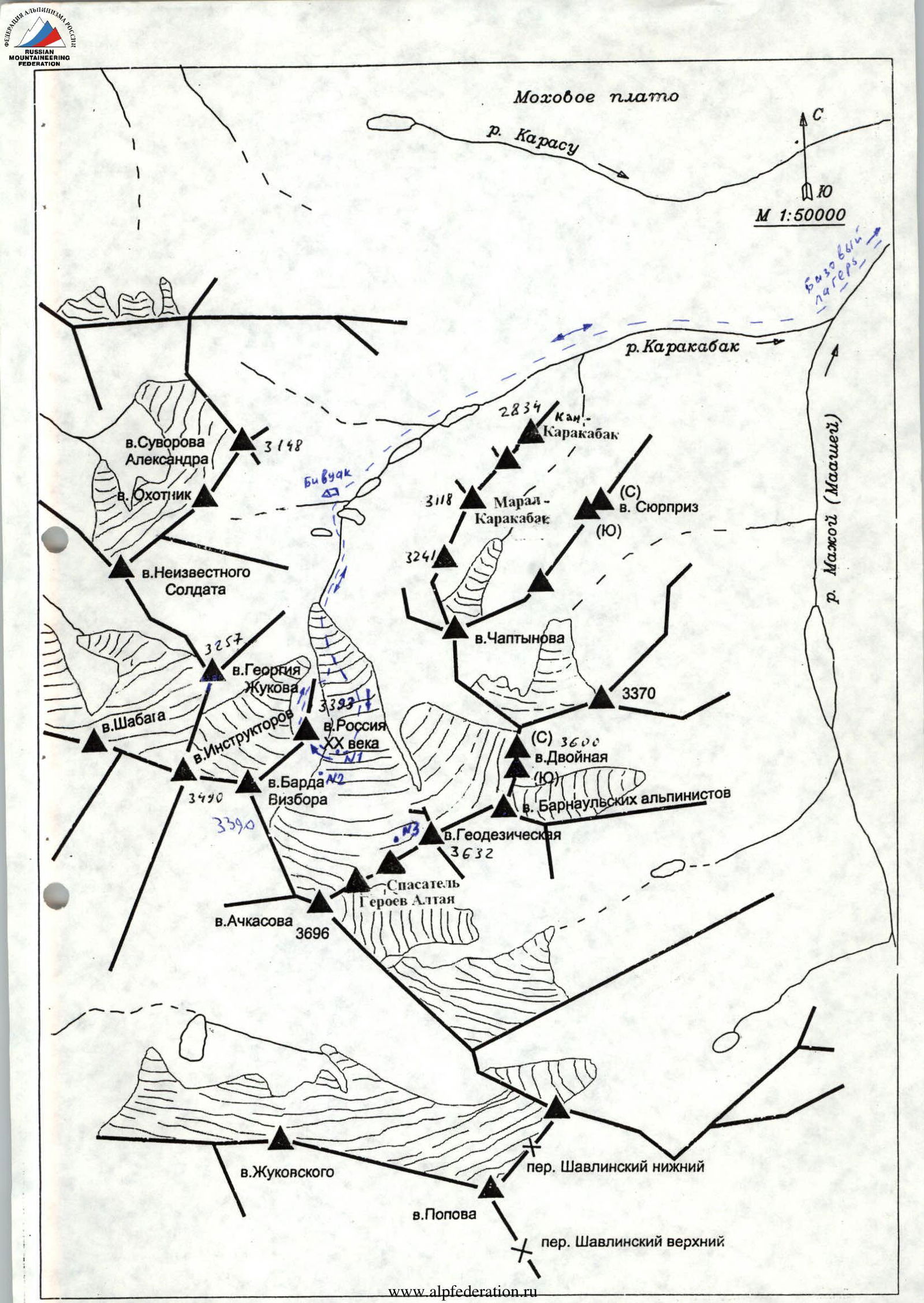
Altai, Severo-Chuysky ridge, Karakabak gorge, 1.2
-
Peak "Russia XX века" via the right spur of the south-eastern wall. Height 3393 m. (In the classification, this peak is named 3100. Routes 55 and 56, section 1.2. It is proposed to return to the name indicated in the note found on the peak by the group that made the first ascent via the north-eastern ridge. In the note, the peak is named "Russia XX века", leader V. Maltsev. The ascent route is not specified. Otherwise, there is a discrepancy. On the topographic map at a scale of 1:50,000, the height of this peak is given as 3393, and the name is 3100.)
-
A first ascent of category 4A is proposed.
-
The nature of the route is combined.
-
Height difference 370 m. Route length 660 m. Length of category 4 sections 130 m. Average slope of the main part 45°, entire route 35°.
-
Used pitons: rock - 6, chocks - 13, ice - 3 (on ascent).
-
Climbing hours - 7 (from the start of the spur to the summit).
-
Leader: A. Drakin - Candidate Master of Sports. Participants: N. Astafurova - 3rd sports category, I. Gorbunova - 2nd sports category, V. Penzev - 2nd sports category, A. Chistyakov - 1st sports category.
-
Coach: A. Drakin - 1st sports category No. 68.
-
Departure for the route 5:00 July 30, 2002, reaching the summit 15:00 July 30, 2002, return to base camp 19:30 July 30, 2002.
-
Organization: Siberian Regional Center for Civil Defense and Emergency Situations and Life and Property Safety.
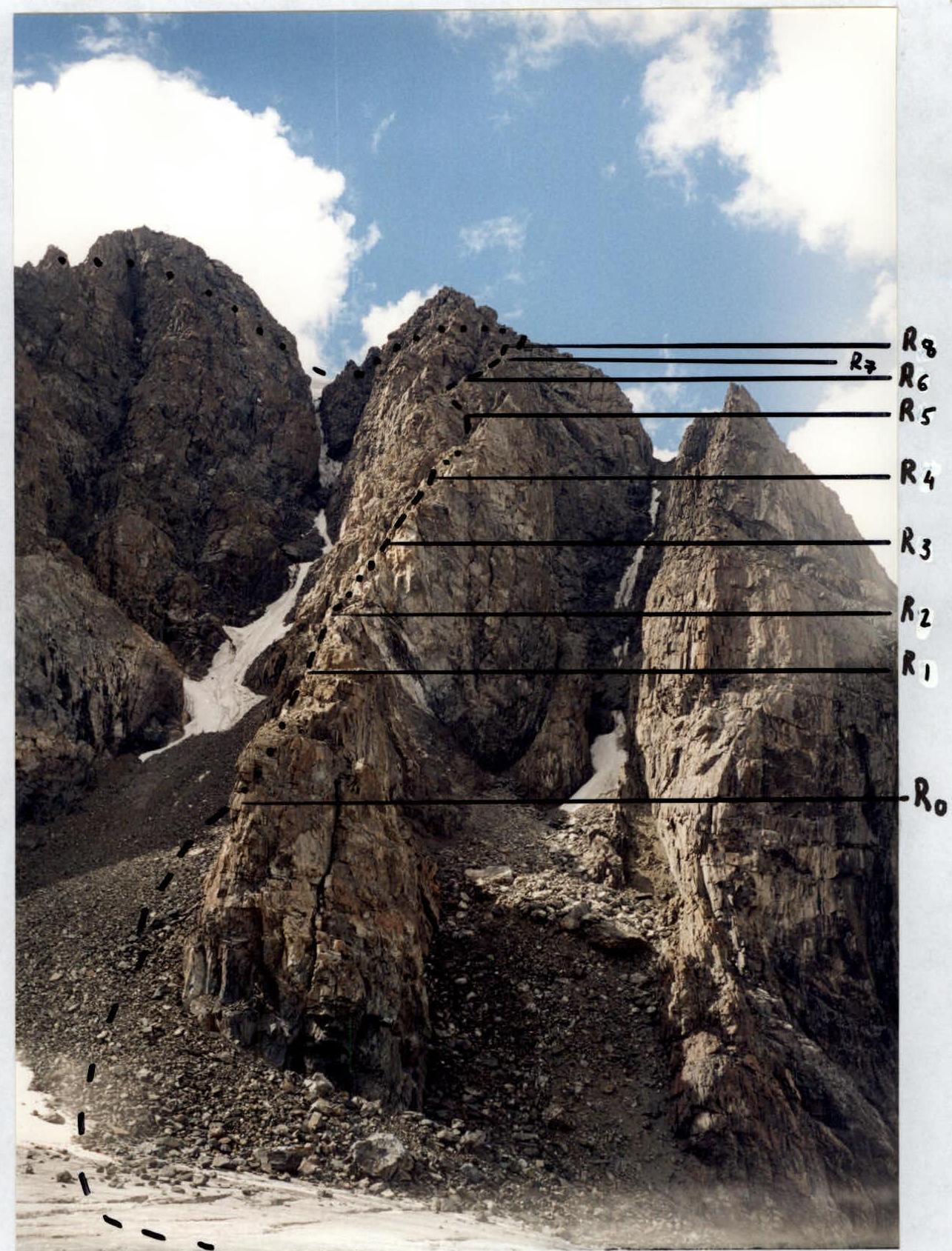
Technical photograph Shooting point No. 1
-
-
- visible path ... not visible path
-
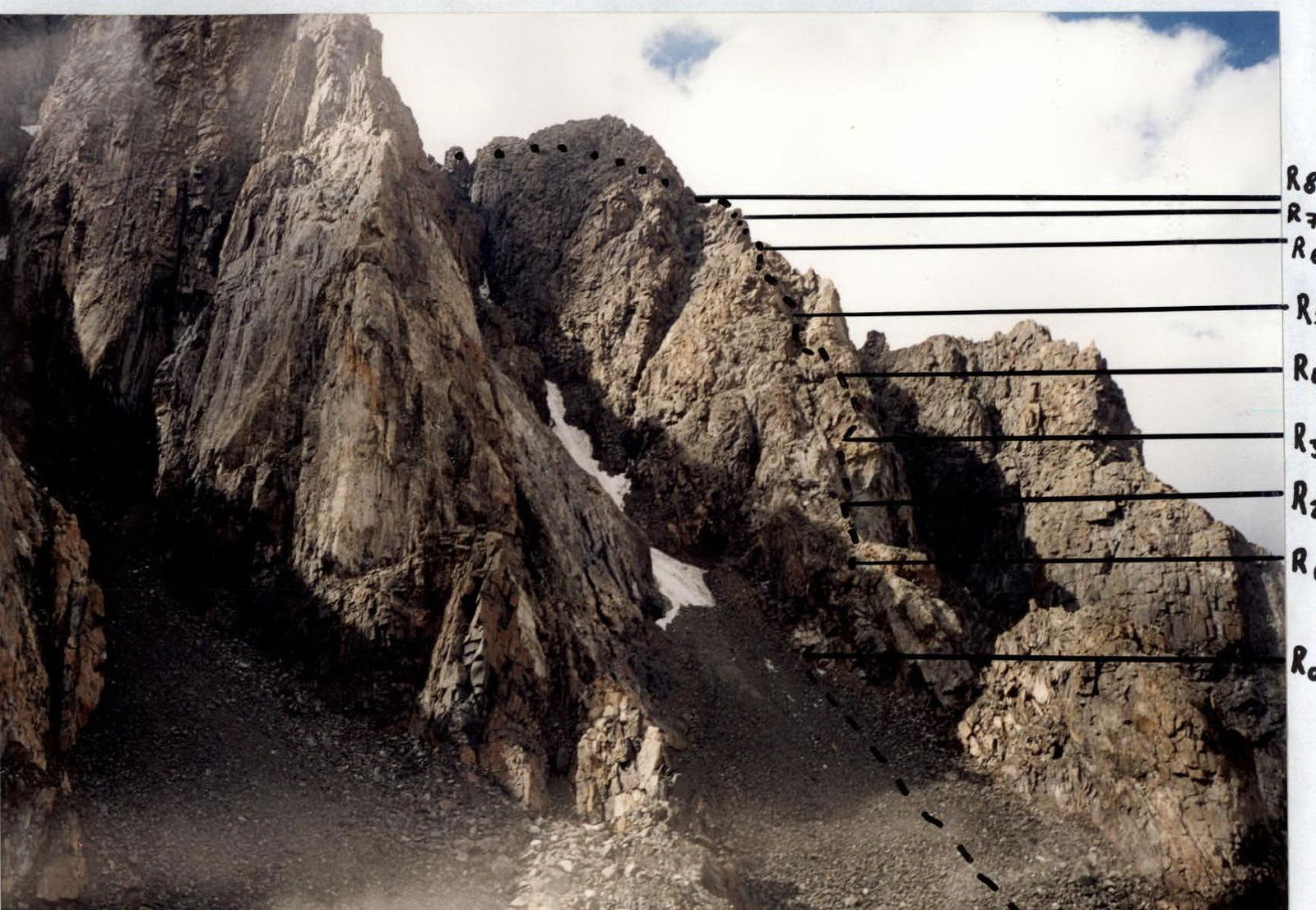
Profile from the left. Shooting point No. 2
-
-
-
-
- visible path .... not visible path
-
-
-
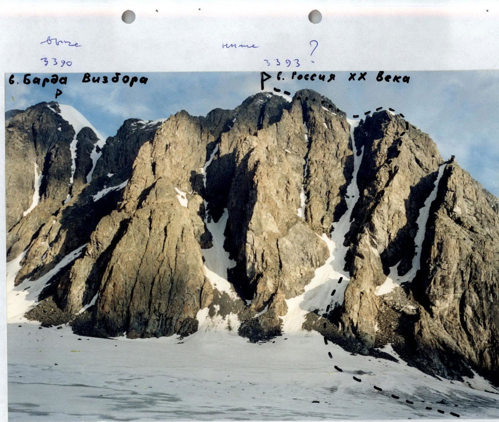
General view photograph of the peak. Shooting point No. 3
Route diagram in symbols M. 1:2500

Brief description of the route
The approach to the start of the route takes 2.5-3 hours from the bivouac located on the bank of the stream flowing from the cirque of peaks Okhotnik - Suvorova. Movement goes along moraine ridges along the stream, then along the glacier under the right spur of the south-eastern wall. Bypassing the lower gendarme on the left, ascend the scree to the start of the route.
R0-R1: Series of ledges and walls. Climbing of medium difficulty. Organization of belays. Rockfall hazard!
R1-R2: Destroyed ridge. Belays.
R2-R3: Movement goes along the inner corner. Then move right to the wall. Belays. Rockfall hazard in the inner corner.
R3-R4: Wall, difficult climbing. Organization of belays.
R4-R5: Movement along the wall leads to an inner corner with many loose rocks. Belay station is inconvenient. Belays.
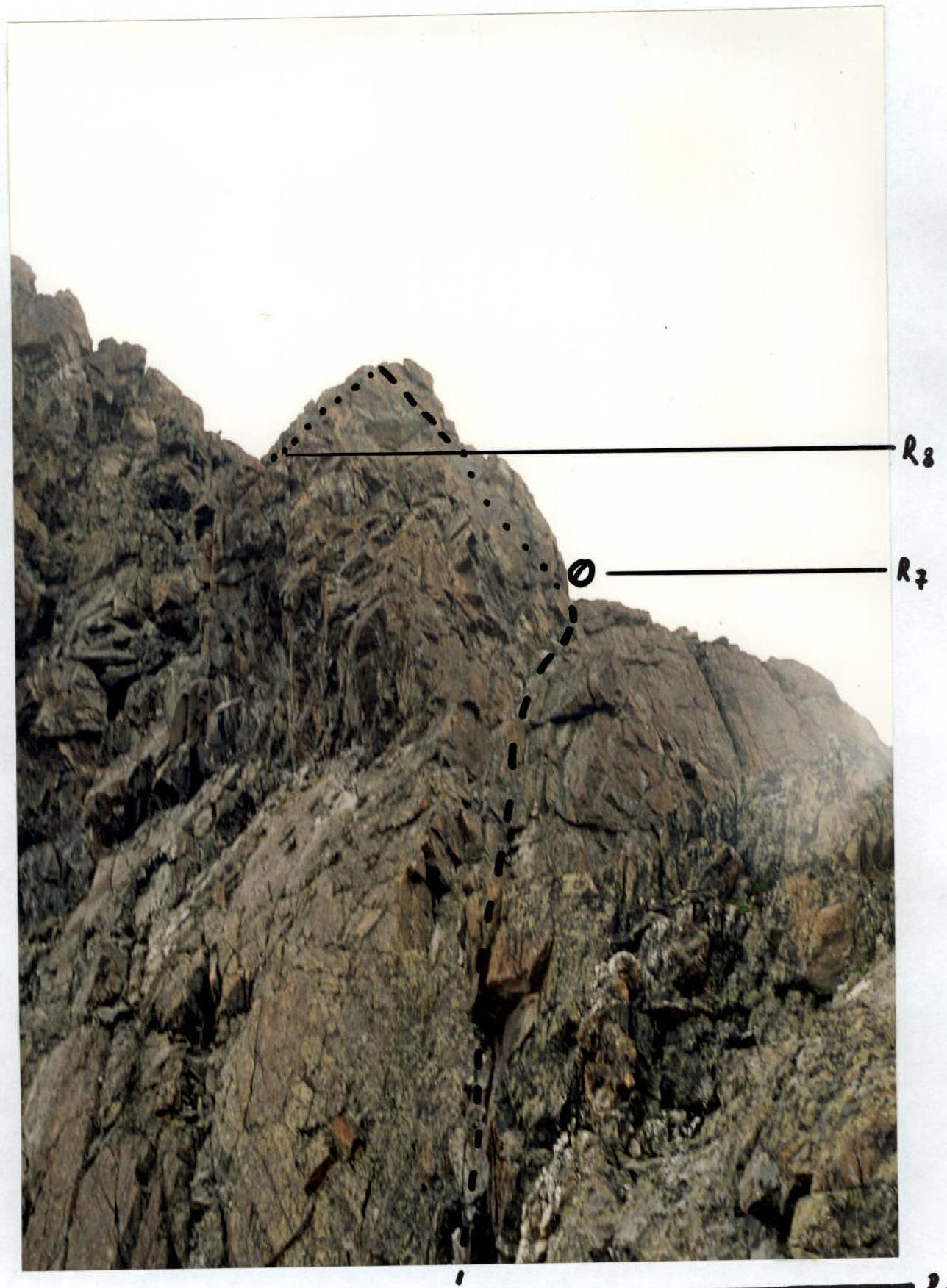
R5-R6: At first along the wall, then along the ridge approach the key section of the route. Belays.
R6-R7: Along the sharp monolithic ridge approach the inner corner. Climbing in the inner corner is difficult. Rocks are monolithic, few cracks for intermediate belays. Station is inconvenient. Belays.
R7-R8: Further ascent is along a difficult wall, which leads to a simpler ridge. Belays.
R8-R9: An easy scree ledge leads under a rock wall.
R9-R10: Rock wall. Belays.
R10-R11: Ridge, rocks are destroyed. Simultaneous movement.
R11-R12: Snow-ice ridge. In the middle part, there is a 50-meter ice pitch with a bergschrund. Passed in turns. Belays via ice screws. Belays can be organized.
- In the middle part, there is a 50-meter ice pitch with a bergschrund.
- Passed in turns.
- Belays via ice screws.
- Belays can be organized.
Descent is via the north-eastern ridge, category 2A. On descent, it is necessary to overcome a 200-meter steep ice slope. Further descent is along a destroyed rock ridge. Rockfall hazard!
Photograph of the most difficult section of the route.
-
-
- visible path — ...... not visible path
-
Safety recommendations
There are many sections with loose rocks on the route. On ascent, avoid couloirs, inner corners, etc., prefer outer forms of rock relief. Descend with all rules for descending scree slopes.
Recommendations for equipment
For organization of intermediate belays and rope protection for a group of four, a set of various pitons and chocks is required, 10-15 pieces.
To overcome ice slopes, it is necessary to have ice screws, 3-5 pieces, and crampons with ice axes for the entire group.
Preliminary assessment of the route's category of difficulty
The route is assessed as more difficult than the route to peak Barnaulskikh alpinistov via the northern slope, category 3B. At the time of submitting the report, this is the most difficult classified route in the area. The most difficult part of the proposed route for classification is the rock section, which is lacking in most routes on Altai. Category 4A is proposed.