
PASSPORT
- Category of first ascent.
- Altai, Severo-Chuysky ridge, Aktru gorge.
- V. Stazerov, 3rd category (3750 m)
- 2B first ascent is proposed.
- Descent from Bolshoy Aktru glacier is 760 m, length is 1600 m.
- Ice screws — 5 pieces.
- Travel hours from camp to camp — 10 hours.
- Overnight stay was not organized, approach and overnight stay are possible (at "Goluboe ozero").
- Leader: Andrey Valentinovich Drakin, Candidate Master of Sports, 1st class, born in 1968.
Participants — personnel of the methodological gathering of mountaineering instructors conducted by the "Siberian Rescue Center". 18 people in total.
- Coach: A.V. Drakin
- Departure on the route on May 7, 1998 at 5:00, return on May 7, 1998 at 15:00.
- Organization: Tomsk Regional Public Organization "Siberian Rescue Center".
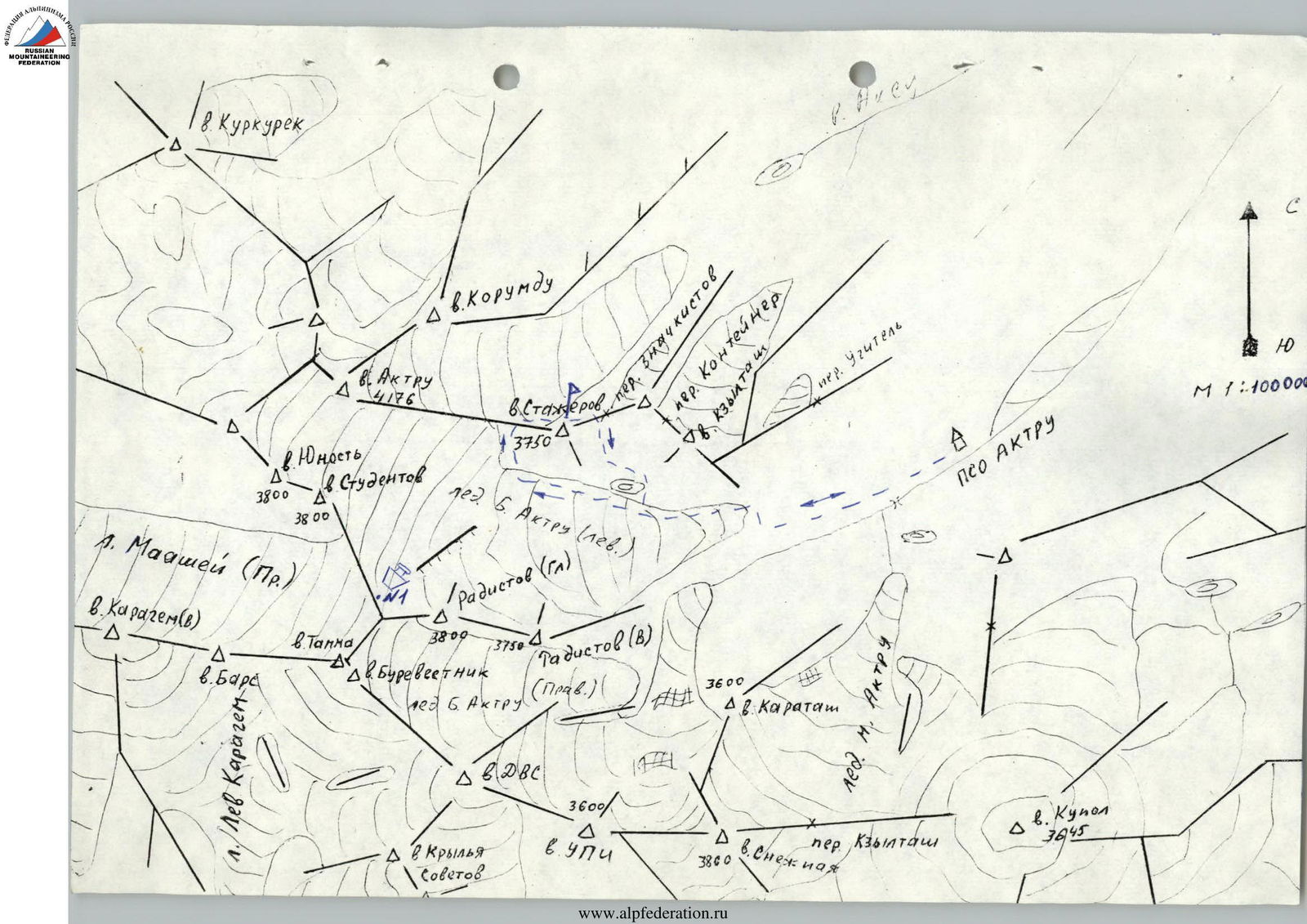
Route map (Scale 1:100000)

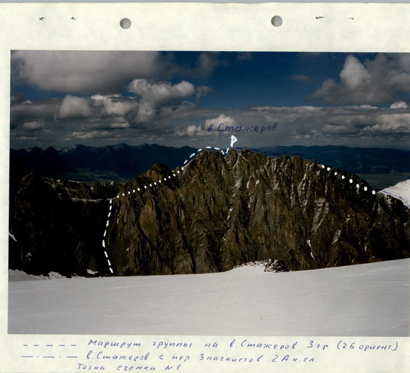
V. Stazerov, 3rd category, 2B (guideline)
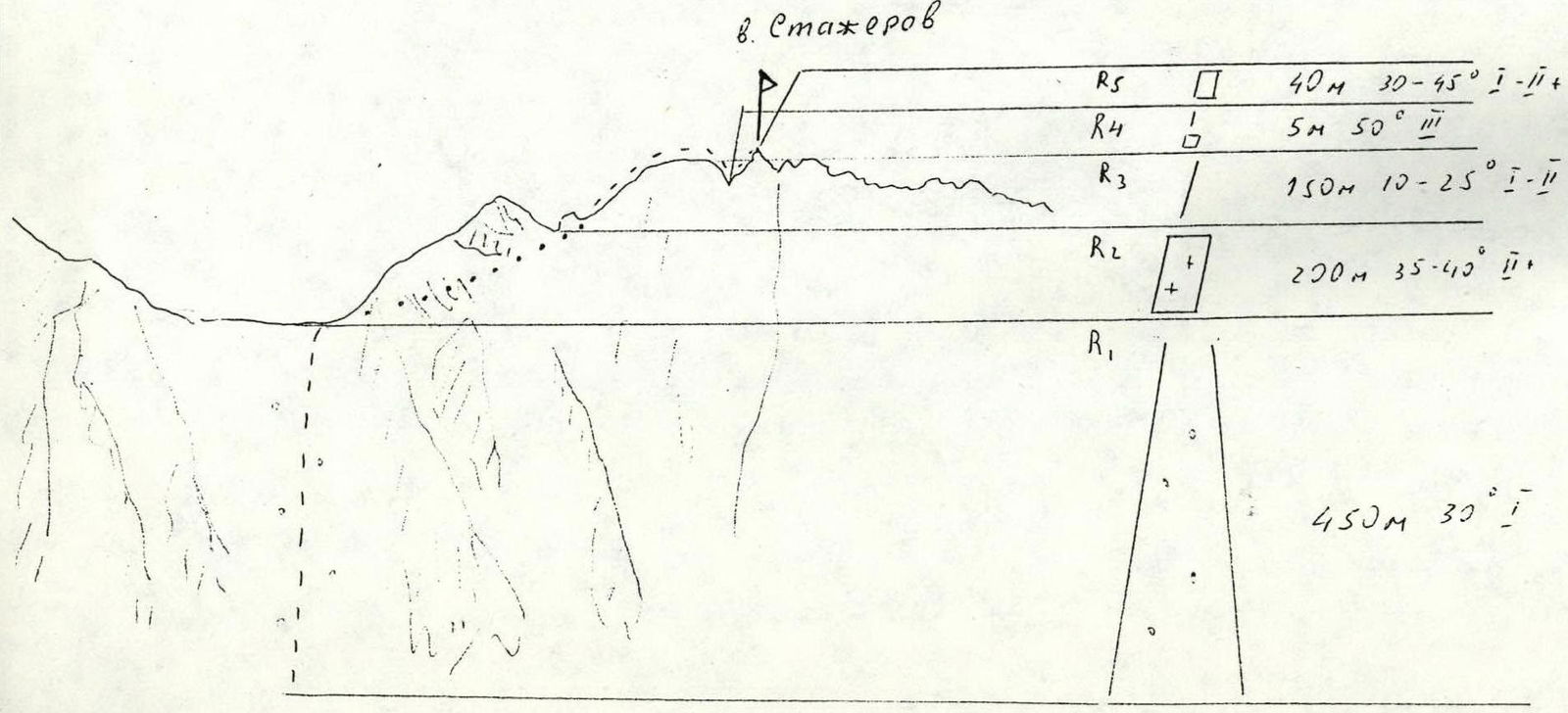
Route sections diagram
- R5: 40 m, 30–45°, difficulty category 1–2
- R4: 5 m, 50°, difficulty category 3
- R3: 150 m, 10–25°, difficulty category 1–2
- R2: 200 m, 35–40°, difficulty category 2
- R1: 450 m, 30°, difficulty category 1
- R0: Start of the route
From Aktru camp, move along the trail upwards along the Aktru river in the direction of the Bolshoy Aktru glacier. The ascent to the glacier goes to the right of the second "baraniy lob" along an implicit talus couloir and then left-upwards along the talus to the glacier tongue. Move along the glacier tongue to the moraine rampart, behind which is "Goluboe ozero". Travel time from the camp is 2–2.5 hours.
On the Bolshoy Aktru glacier, in teams (crevasses!), approach the talus slope that leads to the ridge between Stazerov and Aktru peaks. Ascend to the ridge along the medium to fine talus. Travel time is 2–2.5 hours from "Goluboe ozero".
The key section of the route is bypassing the first gendarme on the left along the ice slope. The length of the section is 4–5 ropes, steepness is 35–40°. Passage with ice screw protection or with the organization of belays if necessary.
The ascent to the second gendarme goes along a simple talus ridge. Further movement along the gendarme's ridge is simultaneous with belay through a protrusion.
The descent to the ridge between the second gendarme and the summit pinnacle is a 5 m wall, difficulty category 3.
The ascent to the summit initially goes along simple rocks — 30 m, then 10 m of rocks with difficulty category 2.
Ascent time from the ridge is 2–3 hours.
Descent along the Western ridge is category 2A, or via the ascent route.
Comments
Sign in to leave a comment