PASSPORT
- Snow and ice class.
- Altai, Severo-Chuysky ridge, Aktru gorge.
- Radistov (Gl.) via the northern slope.
- Proposed category 3A (first ascent).
- Elevation gain 450 m, length 800 m.
- Ice screws 21 pcs.
- Total hours from base camp to base camp 12 h.
- Approach possible with overnight stay at "Goluboe ozero" (Blue Lake).
- Drakin A.V. CMS Sergeev V.P. MS
- Coach Drakin A.V. CMS, instructor 1st cat. No. 68.
- Departure and return July 24, 1997.
- Organizing body Rubtsovsky city sports committee.
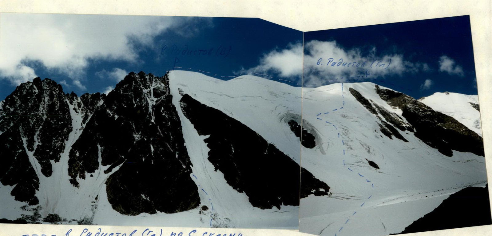
Photo #1. General view of the route
Mt. Radistov (Gl.)
Mt. Radistov (V.)
Route: Mt. Radistov (Gl.) via N slope.
Route: Mt. Radistov via N ridge, 3A category (No. 83 in KTMGV, Altai).
Photo taken from point #1.
Camera: "Smena 8M".
Lens: LOMO T-43 4/40.
www.alpfederation.ru↗

Photo #2. General view of the route
Mt. Radistov (Gl.)
Route: Radistov (Gl.) via N slope.
Point of shooting #2.
Camera: "Smena 8M".
Lens: LOMO T-43 4/40.
www.alpfederation.ru↗

Map of the area
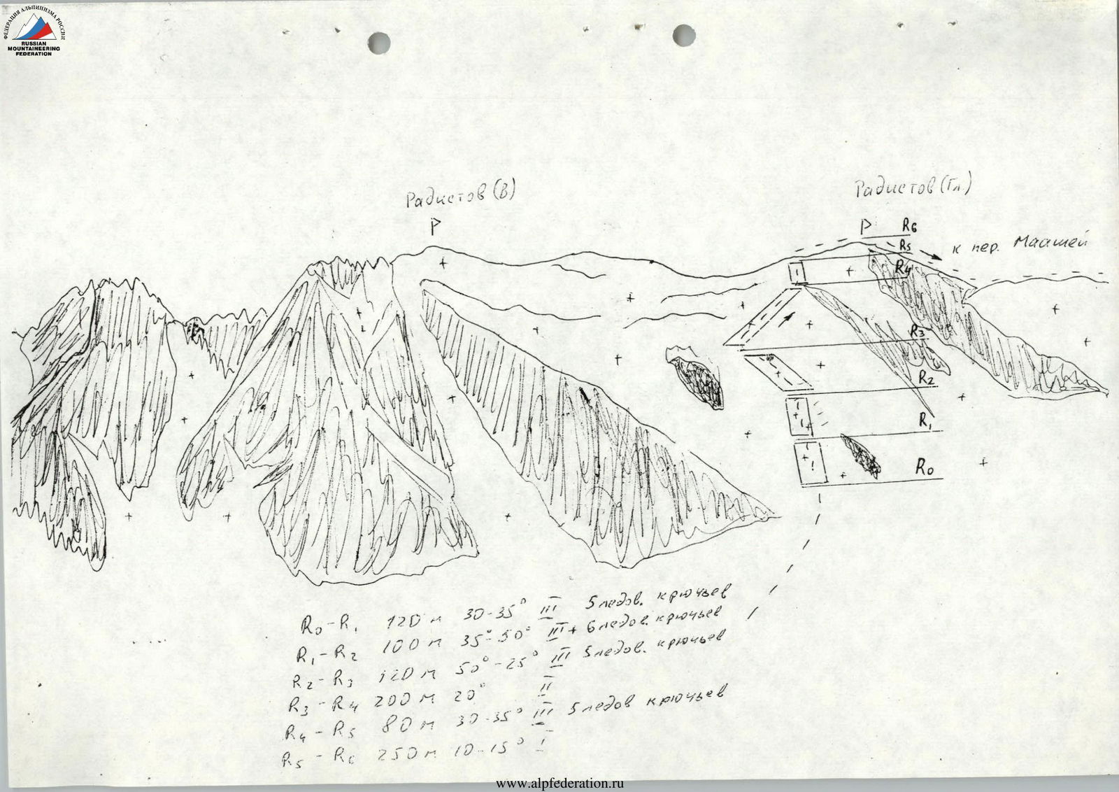
Route diagram with description of sections
- R0–R1: 120 m, 30–35°, 3, 5 ice screws.
- R1–R2: 100 m, 35–50°, 3+, 6 ice screws.
- R2–R3: 120 m, 50–25°, 3, 5 ice screws.
- R3–R4: 200 m, 20°, 3.
- R4–R5: 80 m, 30–35°, 2, 5 ice screws.
- R5–R6: 250 m, 10–15°, 1.
Radistov (Gl.)
via the northern slope. From the base camp near Aktru PSO, follow the trail along the Aktru River to the "baran'i lby" (ram's foreheads), beyond which the Big Aktru glacier begins, its left branch. Take the trail between the second and third "baran'ii lby" to rise to the level of the glacier tongue and cross to the glacier via the moraine. Then move along the moraine ridge along the glacier tongue to a small gorge on the right, formed by the slopes of peaks Kzyl-Tash and Stazhеров. There is a lake behind the moraine ridge. There are many campsites on the moraine ridge, and a stationary glaciologist tent with a stove is located there. Approach time is 2–2.5 hours.
From "Goluboe ozero" (Blue Lake), cross the Big Aktru glacier towards the snow-ice northern slope of Mt. Radistov. The route passes between two rocky outcrops on the slope.
The slope is icy, with a steepness:
- in the middle part - from 30 to 50°,
- above and below - it becomes gentler, up to 25–30°.
Movement is alternating with ice screw protection. When moving in a group, organization of belays will be required. The length of the icy slope is 300–350 m.
Above the second rocky outcrop, movement continues along a snowy slope under the slope of the subpeak, where ice is exposed (2-3 ropes), requiring alternating movement with protection via ice screws.
The path from the subpeak leads to the summit of Radistov (Gl.) along a simple ridge.
Descent via Maashey pass or Mt. Radistov (V.) and then down the southern couloir via the 1B category route.


