Russian Championship in Alpinism
rock climbing category
Report
on the ascent to Maashey peak 4173 m via NW wall (P. Budanova) CTMGV 1.70 of the Rubtsovsk Sports Committee team
Team Leader: Sergeev V.P. Coach: Drakin A.V.
1997
Rubtsovsk Sports Committee: 658224, Rubtsovsk, Lenin Ave., 53–1 phone 2–26–41 Mandrov V.I.
Team Leader: 658218, Rubtsovsk, Svetlova St., 64, apt. 14 phone 5–31–04 Sergeev V.P.
Passport
- Rock climbing category.
- Altai, North-Chuya Range, Maashey gorge.
- Maashey peak via northwest wall.
- 5B category difficulty.
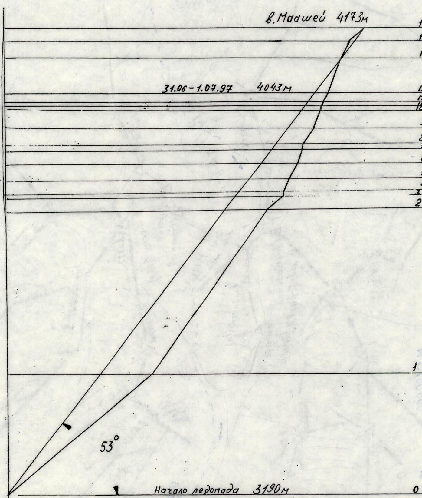
- Height difference 980 m, length 1260 m, average steepness 53°.
- Pitons used: rock — 9 ice — 39 chocks — 48
- Climbing hours: 24 hours, 1.5 days.
- Overnight stay on a small platform made using a "kosynka" (hammock tarp).
- Team Leader: Sergeev Viktor Platonovich — Master of Sports Team members: Vinnikov Evgeny Anatolyevich — 1st sports category Drakin Andrey Valentinovich — Candidate Master of Sports
- Coach: Drakin Andrey Valentinovich — category 1 instructor №68 Candidate Master of Sports
- Departure to the route: July 31, 1997 Summit: August 1, 1997 Return: August 1, 1997
- Organization: Rubtsovsk City Sports Committee.
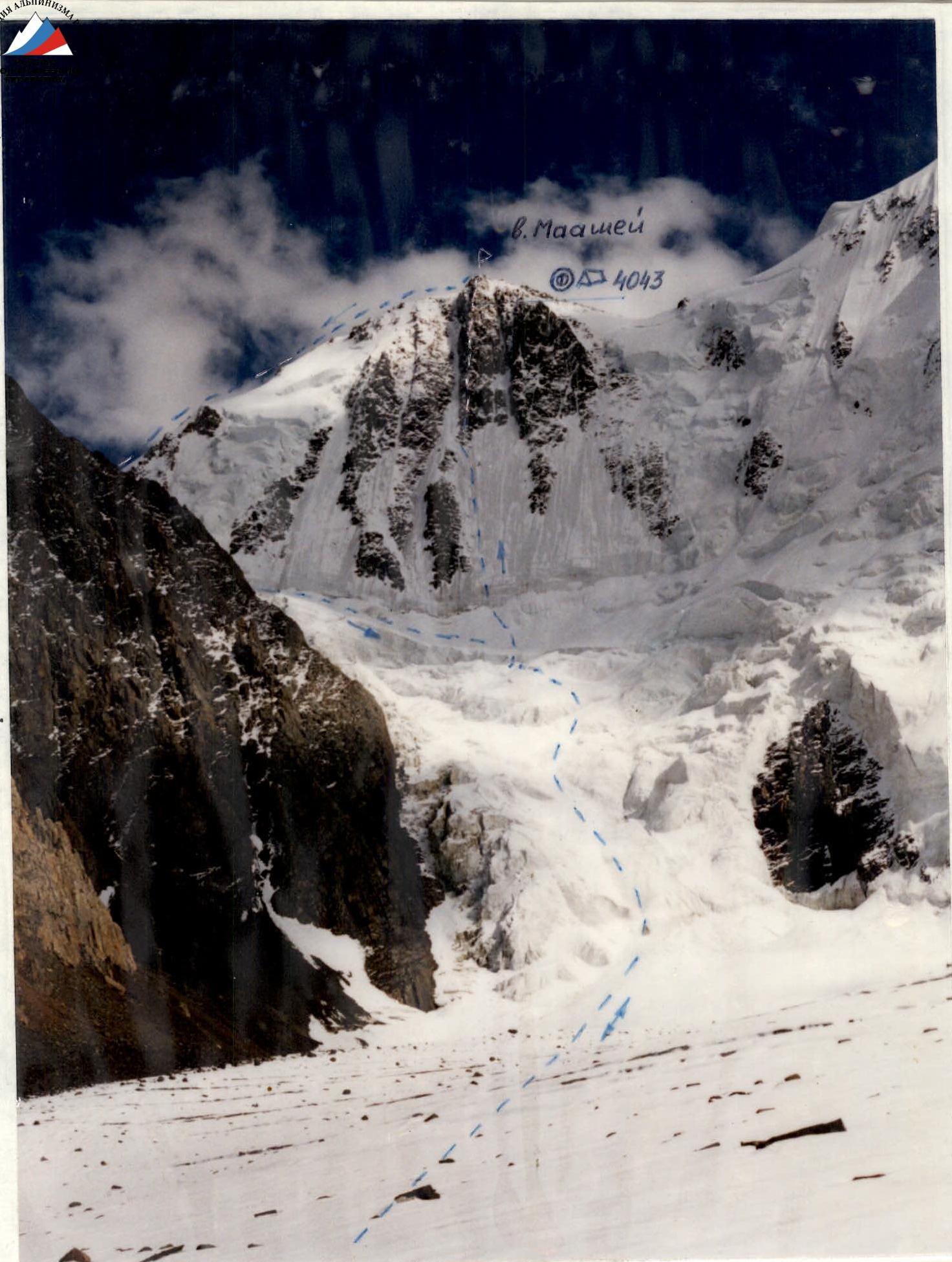
Photo #1. General photo of the peak. Team route Overnight stay Taken with a "Smena 8M" camera, LOMO T-43 lens Shooting point #1
Brief Overview of the Climbing Area
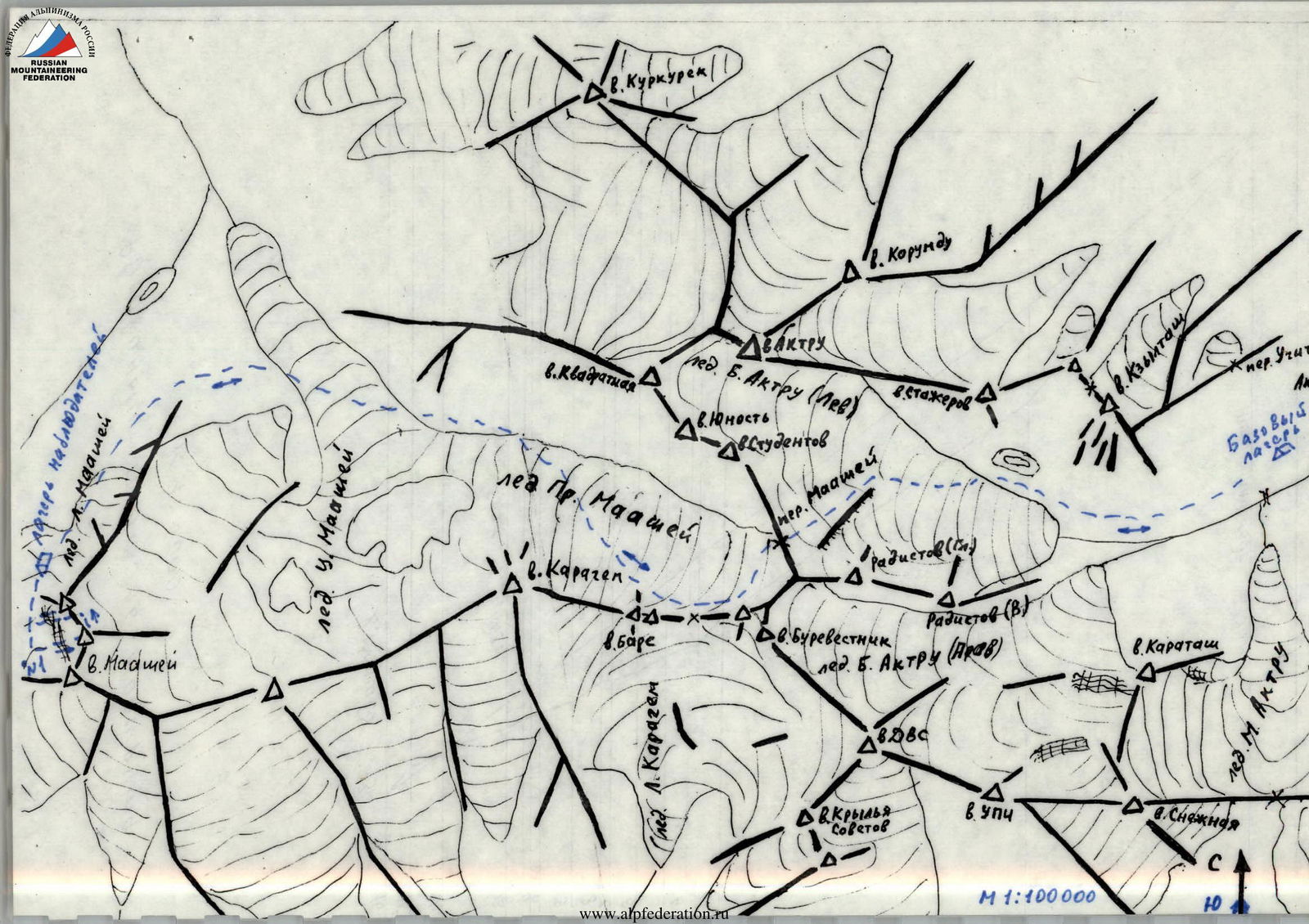
Maashey peak is the highest point of the North-Chuya Range, elevation 4173 m. The area is relatively undeveloped in terms of mountaineering. There are 2-3 routes on the most notable peaks, Maashey and Karagem, established during the existence of the Aktru alpine camp.
To reach the area, one can travel by any means to Biysk, then hire a high-clearance vehicle. Follow the Chuya Highway to Chibit settlement (440 km from Biysk). Cross the Chuya River bridge in Chibit and continue 10-12 km along the Maashey River on a high-clearance vehicle. Then proceed on foot along the trail. The approach from the drop-off point to the foot of Maashey peak takes 6-8 hours. The base camp can be conveniently set up on the last forest clearings before the Maashey glacier.
An alternative route goes through the Aktru gorge. The Aktru Search and Rescue Team of the Gorno-Altaisk Rescue Service operates on the site of the former Aktru alpine camp.
Route:
- From Biysk to Kurai settlement — 480 km, along the Chuya Highway.
- Then 20 km across the Kurai steppe, followed by 10 km through the Aktru gorge to the SAR team.
The last 30 km require a high-clearance vehicle.
From Aktru gorge to Maashey gorge, the path lies through Maashey pass (2B category difficulty). The approach takes 8-14 hours, depending on the distance from the pass to the route. This route was used by instructors from the Aktru alpine camp and was chosen by the Rubtsovsk Sports Committee team for the ascent to Maashey peak via the NW wall (5B category difficulty, P. Budanov's route).
Drawn profile of the route M 1:5000
Pre-Climb Preparation
The initial materials for preparation were: a) a copy of the first ascenders' report; b) a photograph taken in 1996 during a group of Rubtsovsk climbers' trip to the Shavlin lakes area.
The obtained information allowed the team to determine the ascent tactics and select the necessary equipment. For example, the report indicated that there were no convenient platforms for overnight stays on the route. The team brought a "kosynka" (hammock tarp), which enabled them to prepare a small platform for the night. Considering the unstable weather, the team planned the ascent with one overnight stay and took extra food and fuel for two additional days in case of a forced wait.
All team members completed 2-3 ascents with the training group's participants before heading to the route for acclimatization and training in the Aktru gorge area.
Since the ascent was to take place in a different gorge, a group of observers with communication means and equipment was organized to provide assistance if needed. The observers were stationed in a camp under the route.
Interaction with the Aktru SAR team was also established.
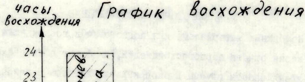
Ascent Schedule
Team's Tactical Actions
The team employed the following tactical approach for the ascent. The first climber moved with bottom rope protection on a double rope while the second climber followed. Meanwhile, the third climber moved along the fixed ropes, removing pitons and carrying the rope.
This method was used on both ice and rock slopes. On the ice slope, Sergeev V.P. worked as the first climber, while on the rock slope, Vinnikov E.A. led. The icefall proved unexpectedly challenging, requiring alternating movement with piton protection from the very first steps.
The ascent proceeded smoothly and calmly, without any incidents. The weather was stable and clear during the day. Snow fell and a blizzard occurred at night. Communication with observers was maintained via "ASom" radios. Observers were stationed in a camp forty minutes' walk from the start of the route.
The overnight stay was organized at an altitude of 4043 m on a small platform made using a "kosynka".
Table of food and fuel supplies.
| № | Name | Weight (kg) |
|---|---|---|
| 1 | sausage | 1 |
| 2 | lard | 1 |
| 3 | Chinese noodles, 10 packs | 0.7 |
| 4 | canned fish, 5 cans | 1.25 |
| 5 | canned meat, 2 cans | 0.8 |
| 6 | crackers | 1 |
| 7 | sugar | 0.5 |
| 8 | tea | 0.1 |
| 9 | chocolate | 0.9 |
| 10 | nuts | 0.5 |
| 11 | raisins | 0.5 |
| 12 | dry drinks | 0.4 |
| 13 | primus stove | 1.2 |
| 14 | gasoline | 1.2 |
| TOTAL | 11.25 |
The weight of the food was determined based on 0.9 kg per person per day. The team planned for two days of ascent and two reserve days in case of a forced wait.
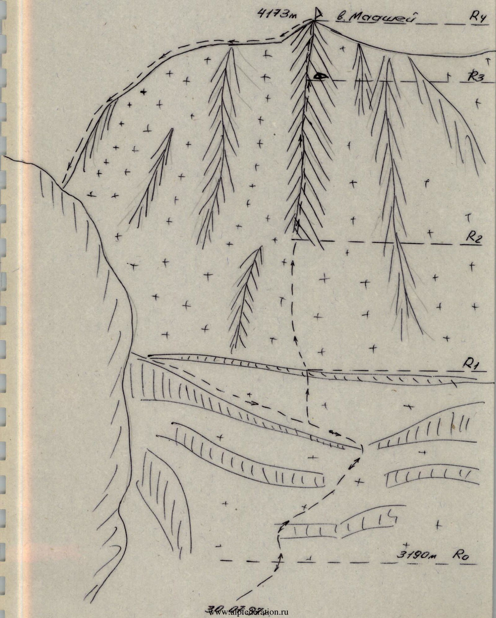
Route Diagram
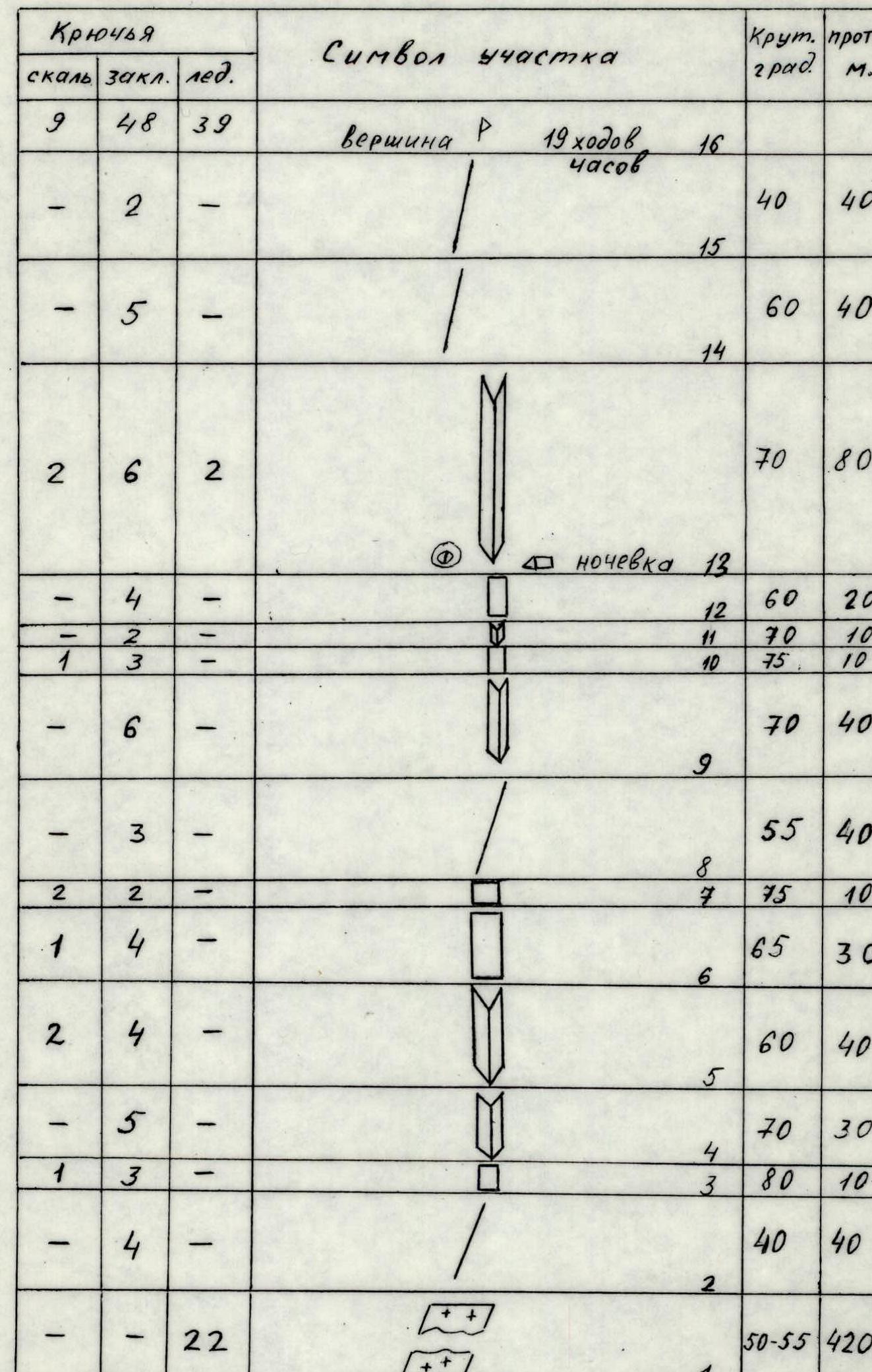
Route diagram: scale 1:2000
| Section | Rock Pitons | Chocks | Ice Pitons | Steepness (°) | Length (m) | Category | Notes |
|---|---|---|---|---|---|---|---|
| Summit | |||||||
| R15–R16 | 2 | 40 | 40 | 3 | |||
| R14–R15 | 5 | 60 | 40 | 5 | |||
| R13–R14 | 2 | 6 | 2 | 70 | 80 | 5 | Overnight stay |
| R12–R13 | 4 | 60 | 20 | 5 | |||
| R11–R12 | 2 | 70 | 10 | 5 | |||
| R10–R11 | 1 | 3 | 75 | 10 | 5 | ||
| R9–R10 | 6 | 70 | 40 | 5 | |||
| R8–R9 | 3 | 55 | 40 | 4 | |||
| R7–R8 | 2 | 2 | 75 | 10 | 5 | ||
| R6–R7 | 1 | 4 | 65 | 30 | 5 | ||
| R5–R6 | 2 | 4 | 60 | 40 | 5 | ||
| R4–R5 | 5 | 70 | 30 | 5 | |||
| R3–R4 | 1 | 3 | 80 | 10 | 6 | ||
| R2–R3 | 4 | 40 | 40 | 4 | |||
| R1–R2 | 22 | 50–55 | 420 | 5 | |||
| R0–R1 | 15 | 30–55 | 400 | 4 |
Route Description by Sections
R0–R1. Icefall. Steep sections of 60–70 m end in snow-covered ledges. A large crevasse in the upper part requires crossing vertical ice walls of 5–10 m. Piton protection is required throughout.
R1–R2. Ice slope. Steepness 50–55°. Alternating movement with piton protection. The first climber worked with an ice axe.
R2–R3. Ridge. Rocks are smooth, snow-covered, with piton protection.
R3–R4. Steep, complex wall. Passed with free climbing at the limit.
R4–R8. Series of inner corners and walls:
- Rocks are broken, steep, iced, and snow-covered.
- Protection with pitons and chocks.
R8–R9. Ridge. Steep, with many loose rocks. Piton protection.
R9–R13. Series of walls and inner corners:
- Rocks are broken, snow-covered, iced.
- Piton protection.
- Uncomfortable overnight stay.
- Preparing a platform requires special equipment (kosynka) or a lot of time.
- Convenient platforms are absent throughout from the bergschrund to the summit.
R13–R14. Inner corner filled with ice. Piton protection, some sections can be protected with ice screws.
R14–R16. Ridge, flattening out towards the top and leading to the summit cairn. Piton protection, upper part protected by a rock outcrop.
Equipment Table
| № | Name | Quantity | Weight |
|---|---|---|---|
| 1. | Rope | 3 × 40 m | 10.5 |
| 2. | Carabiner | 25 | 2 |
| 3. | Ice axe | 1 | 1.5 |
| 4. | Ice hammer | 2 | 2.8 |
| 5. | Ice hammer (for ice screws) | 1 | 1.5 |
| 6. | Ice screws | 6 | 0.6 |
| 7. | Harness | 3 | 4.5 |
| 8. | Rappel slings | 2 | 0.5 |
| 9. | Extension slings | 10 | 2 |
| 10. | Rock pitons | 8 | 0.4 |
| 11. | Crampons | 3 | 3 |
| 12. | Chocks | 20 | 2 |
| 13. | Sleeping bag | 1 | 2 |
| 14. | Helmet | 3 | 3 |
| 15. | Tent | 1 | 2 |
| 16. | Kosynka (hammock tarp) | 1 | 1 |
| 17. | Down jacket | 3 | 6 |
| 18. | Personal gear | 3 | 6 |
| 19. | First-aid kit | 1 | 1 |
| 20. | Radio set and batteries | 1 | 1 |
| 21. | Backpack | 3 | 3 |
| Food and fuel | 11.25 | ||
| TOTAL | 64.55 |
Initial backpack weight 21.5 kg.