Ascent
The ascent to v. Krasavitsa via the northern wall (approximately 3A category of difficulty) was made by a group of climbers from the Altai Regional Federation of Alpinism expedition.
GROUP COMPOSITION
- Kuznetsov N. A. 2nd sports category
- Bondarchuk N. M. Master of Sports
- Luzhetsky B. N. Master of Sports
- Makeev V. P. CMS
- Morgachev V. N. 1st sports category
- Fedorov V. A. 1st sports category
Group Leader: KUZNETSOV N. A.
Route Description
From the parking near the Middle Shavlinsky Lake, proceed up the stream towards the glacier of v. Krasavitsa. At the foot of the glacier, the lake is circumvented to the right. In the direction of the lateral moraine of the Krasavitsa glacier, cross the Shavla River and ascend the slope of the moraine rampart until intersecting with a clearly visible trail. Continue along the trail towards the left (orographically) side of the Krasavitsa glacier.
The glacier has two steps:
- The first step is traversed on the left (orographically) side of the glacier, avoiding numerous crevasses, moving in rope teams with alternating belays.
- The path to the second step of the glacier is via a flat plateau with a slight gain in altitude. Move along the central part due to the danger of hanging glacier avalanches.
- The second step is less complex and is traversed simultaneously.
Upon reaching the flat plateau, continue moving towards the Krutoy Pass, bypassing the northwest ridge of v. Krasavitsa. Having circumvented the northwest ridge, a clear break, referred to as the "window," is visible in its upper part. Proceed towards the "window," reaching the middle talus, bypassing crevasses to the left (orographically).
Upon approaching the talus, the start of the route is reached. The approach time is 3–3.5 hours.
The route begins along talus shelves towards the "window" in the northwest ridge. Movement is simultaneous, with belays on protrusions. The ascent to the "window" takes 1–1.5 hours.
At this point, cross the northwest ridge and, moving along it, proceed to the key section of the route. Ahead is a wall (about 8 rope lengths) leading to the northern ridge of v. Krasavitsa. The steepness is 60–70°, the rocks are of medium difficulty, highly deteriorated in the upper part, with a risk of rockfalls. Belays are via pitons — 6 pitons were hammered.
Having passed the wall, reach a saddle on the northern ridge, where a short rest can be arranged if needed. The time taken to pass the wall is 2–2.5 hours.
Further on, the terrain changes to ice and snow, requiring crampons. Ahead is an ice climb with a steepness of 30–35°, extending over 3–4 rope lengths. Traverse on the front teeth of crampons with alternating belays. Two ice screws were placed.
Further on, there are two more snow-ice climbs, each 100–150 m long, but with reduced steepness to 20–25°. Traverse with alternating belays via an ice screw.
The third climb leads to a rocky outcrop. The movement time is 2–2.5 hours. From here, it's 40–50 minutes to the summit. Crampons can be removed here.
Proceed towards v. Krasavitsa along a gentle but sharp snow ridge. In some places, careful alternating belays are required due to the ridge overhanging to the east with powerful cornices.
The summit is a distinct rocky outcrop with a cairn in the center. The time from the camp to the summit is 12–14 hours. Descent via the ascent route takes 3–4 hours. The entire ascent takes 14–16 hours.
Conclusion on Route Difficulty
The route was completed in 15 hours, with 11 hours spent on the ascent and 4 hours on the descent. 6 rock and 3 ice screws were hammered.
Recommendations for future climbers:
- Group size — not more than 4 people.
The route is combined and sufficiently technically challenging. The group rates the route as 3A category of difficulty.
Recommendations:
- All participants should have crampons.
TABLE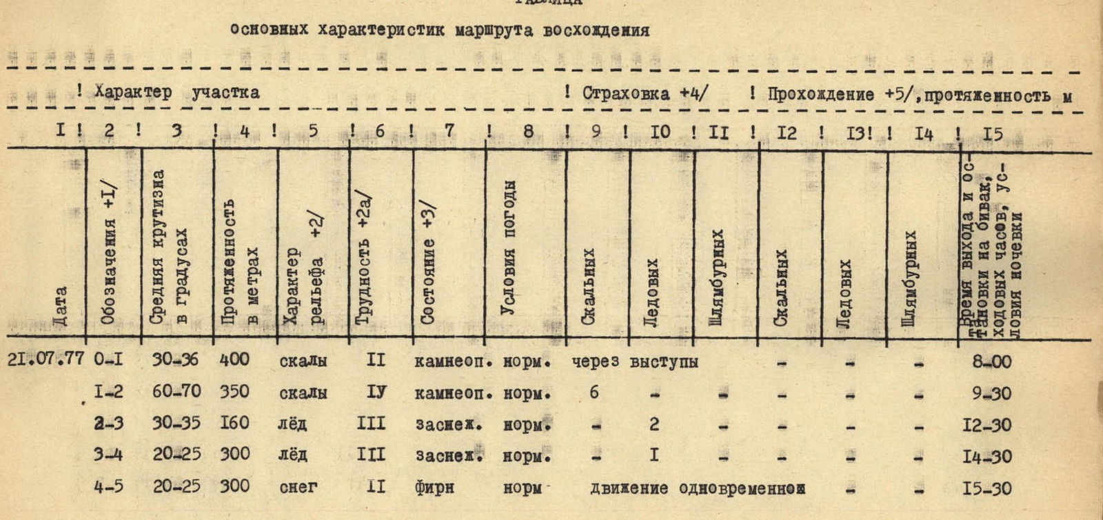
Table of Main Characteristics of the Ascent Route
| Date | Designations | Average Steepness in Degrees | Length in Meters | Terrain Type | Difficulty | Condition | Weather Conditions | Belay (Rock) | Belay (Ice) | Belay (Bolt) | Passage, Length (Rock) | Passage, Length (Ice) | Passage, Length (Bolt) | Time, Overnight Conditions |
|---|---|---|---|---|---|---|---|---|---|---|---|---|---|---|
| 21.07.77 | R0–R1 | 30–36 | 400 | rocks | 2 | rockfall | normal | via protrusions | – | – | – | – | – | 8:00 |
| – | R1–R2 | 60–70 | 350 | rocks | 4 | rockfall | normal | 6 | – | – | – | – | – | 9:30 |
| – | R2–R3 | 30–35 | 160 | ice | 3 | snow-covered | normal | – | 2 | – | – | – | – | 12:30 |
| – | R3–R4 | 20–25 | 300 | ice | 3 | snow-covered | normal | – | 1 | – | – | – | – | 14:30 |
| – | R4–R5 | 20–25 | 300 | snow | 2 | firn | normal | Simultaneous movement | – | – | – | – | – | 15:30 |
