Sheet 1
Passport
-
Class — rock, route character — combined.
-
Region — Altai, Aktru gorge.
-
Peak Karatash, via N. side, western glacier "Tronov's pants".
-
Proposed — 5B category of difficulty, first ascent.
-
Route characteristics:
elevation gain — 975 m, length — 1400 m length of sections with V and VI category of difficulty — 195 m average steepness — 50°, average steepness of the main part (icefall) — 90°, 120 m.
-
Pitons left on site — 1 rock, driven pitons — 96 pieces, of which rock — 24, ice — 72.
-
Team's climbing hours — 12 h 20 min.
-
No overnight stays.
-
Participants: Afanasiev A.E. — Master of Sports, Konshakov I.I. — 1st category.
-
Team coach: Afanasiev A.E. — category I instructor-methodologist.
-
Entry to the route and return — May 7, 1997.
-
Organization: Irkutsk City Club "Vityaz".
Sheet 2
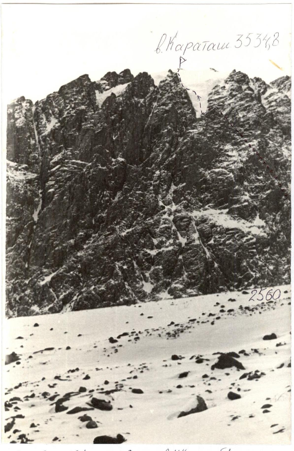
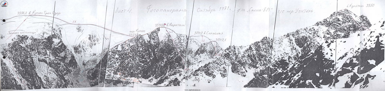
Photo of the profile on the right
October 1981, camera "Smena-8M", lens №2.
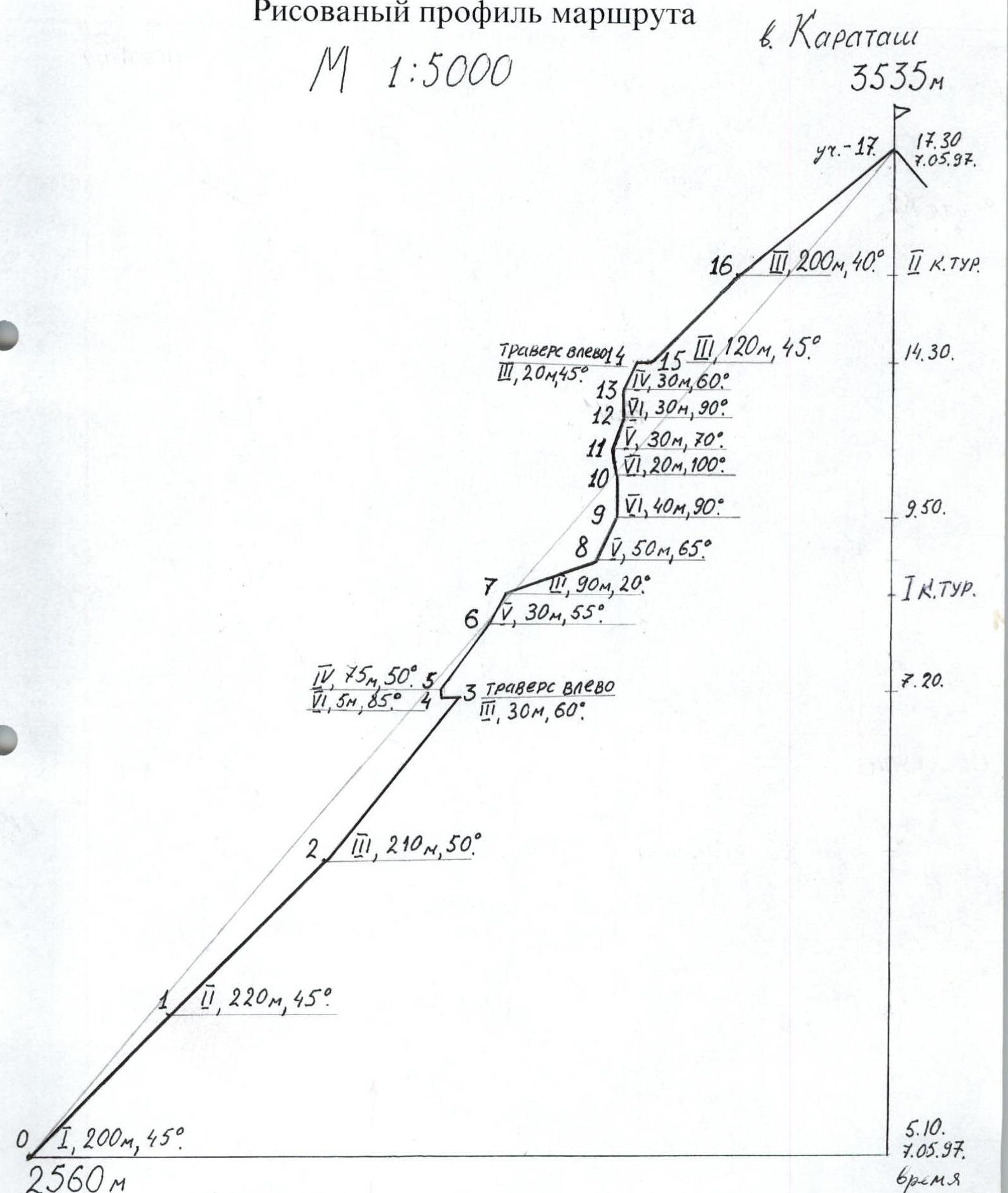
Sheet 3
Drawn profile of the route
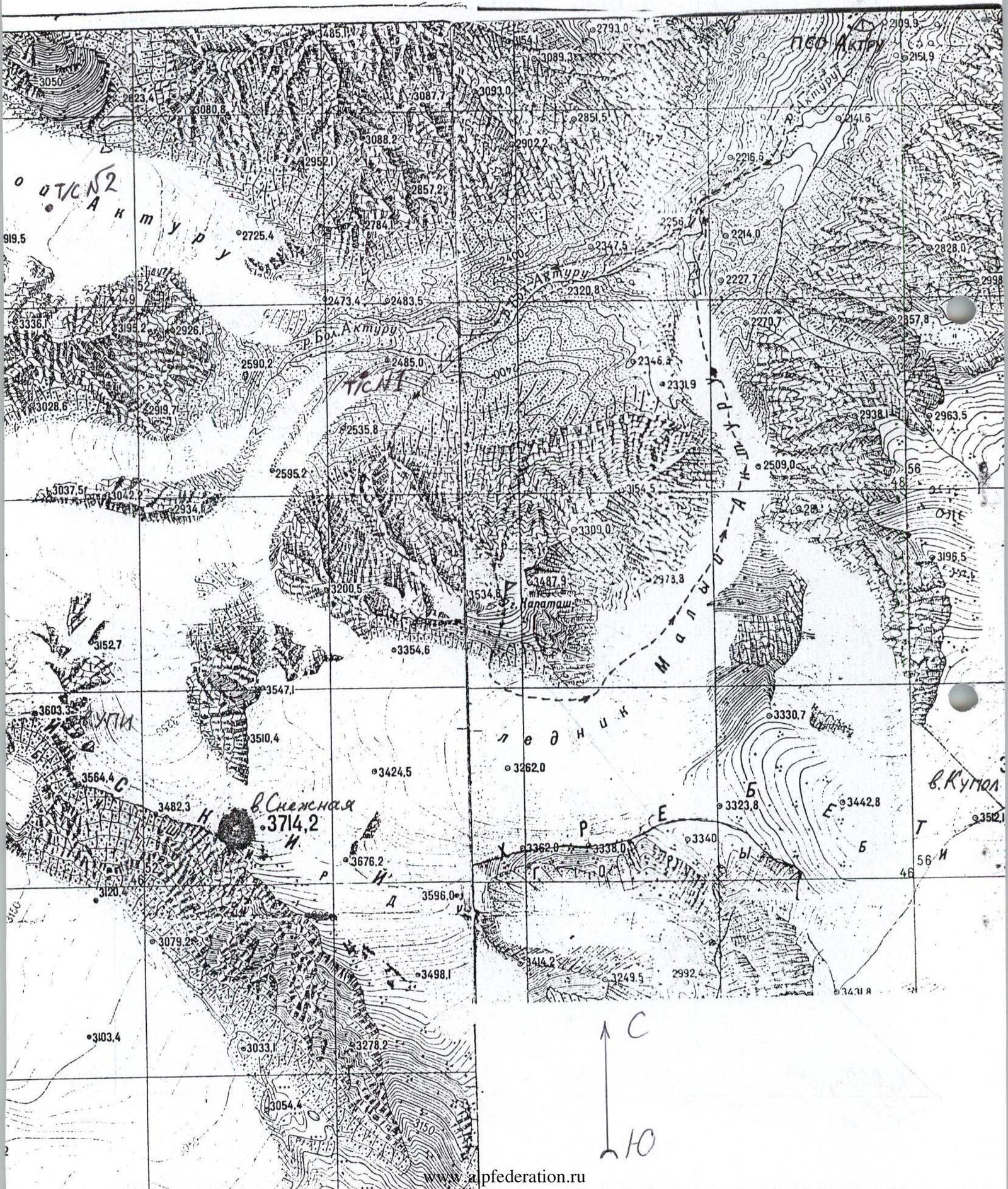
Map-scheme of the region. Scale 1:25 000
Sheet 5
Brief overview of the region
Aktru gorge is located in the Altai mountains, in the North-Chuya ridge. The region is sufficiently explored due to the presence of a stationary alpine camp until the 1970s, followed by annual alpinadas, gatherings, and methodological events from various cities. All prominent peaks in the gorge have been ascended. Many routes are not classified. Some were opened for the camp during its operation but were not included in the classifier.
The region is snowy and has a network of developed valley glaciers (up to 10 km long). The gorges are trough-shaped. Routes are predominantly ice-snow and combined. In the neighboring Maashay gorge, three 5B category routes are classified. In Aktru gorge, two 5 category routes have been ascended:
- to peak Zhandarm Snezhnoy — ice (popular);
- to peak Tetё — rock (one ascent recorded). Both routes are not classified.
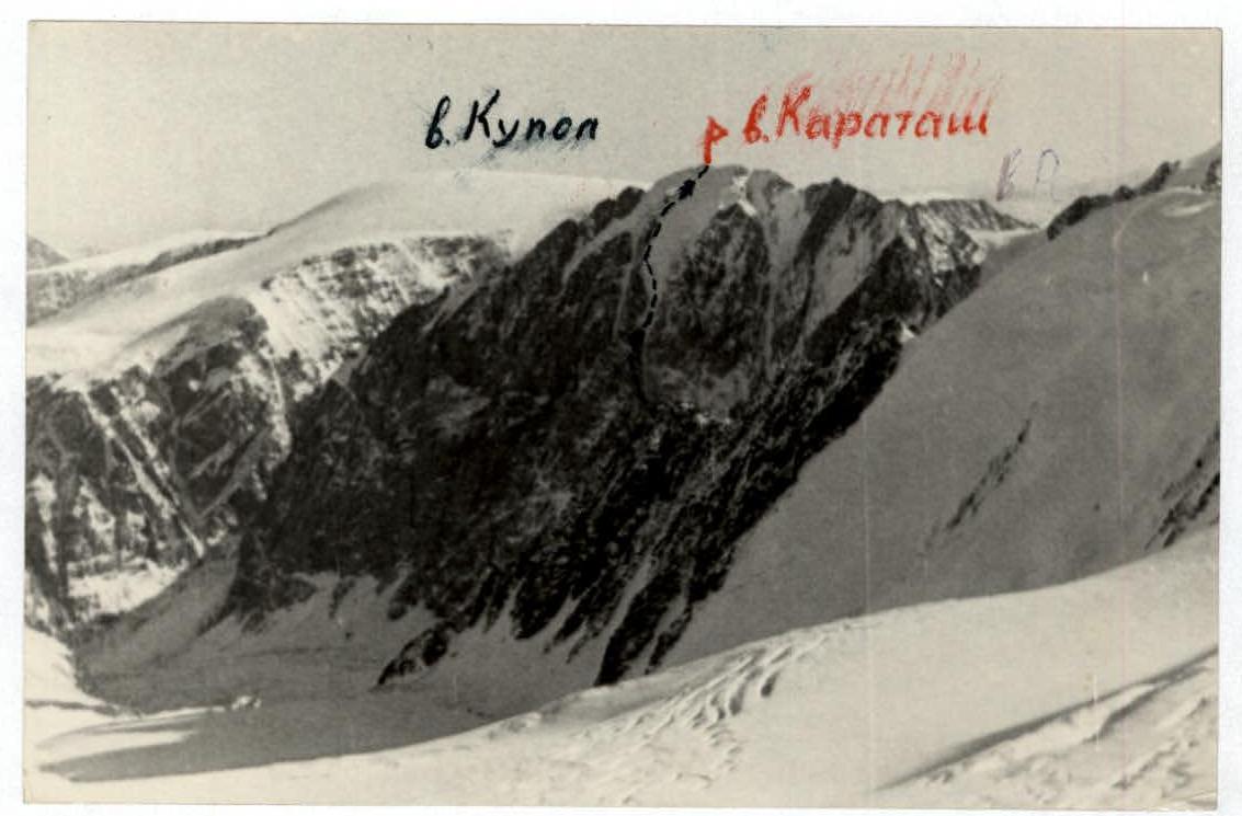
Peak Karatash has a massive rock wall with a northern exposure and a two-lobed High glacier near the summit. The wall's elevation gain is up to 1000 m. There are up to 10 logical routes and options of the highest category. Until now, there has been no completed ascent of the main part of the wall. A strong Kemerovo team attempted to ascend the central part of the rock wall 2 years ago. The wall's middle and right parts are composed of slate with reverse holds, extremely fragile.
The facade of the North wall of peak Karatash is oriented semi-profile towards the base camp, within 1 hour's approach. However, few are willing to take on the challenge.
The terrain is diverse, complex, and hazardous. To determine a route, one needs to study the terrain's folds under different lighting, snow conditions, and from various viewpoints for an extended period. To the east (left) of the tongue of the Maly Aktru glacier, a 4B category route is laid out, which was classified for the camp but is unpopular due to its complexity. On the right part of the wall, there is a classified 4A category route (CTMMTB — 1.49, p. 5). There is an opinion that the route has changed beyond recognition after the 1970s earthquake. Several reconnaissance groups' ascents during Afanasiev's release did not clarify the route's location.
The present ascent of Karatash's N. wall via the western glacier "Tronov's pants" is the first attempt on the wall's significant possibilities.
Aktru gorge has enough routes for achieving 2nd category standards. In the summer, there is an opportunity to visit neighboring gorges and ascend routes of 4B–5B categories.
The primary character of the region's routes is ice. With the development of the northern walls of peaks Tetё, Kzyl-Tash, and Karatash, rock routes will emerge.
Since 1993, a rescue team has been operating in the gorge, with long-range radio communication available.
The region is suitable for alpinism events in both summer and winter.


Sheet 7
Tactical actions of the team
The tactical plan was based on the safety of the ascent due to objective and subjective reasons. Accordingly, the following time schedule was drawn up:
- 3:00 — departure from base camp with observers
- 5:00 — start of the route
- 8:00 — passage through the couloir, transition to rocks
- 10:00 — passage under the vertical ice
- 15:00 — overcoming the icefall
- 18:00 — reaching the summit
Upon reaching the summit after 18:00 — overnight stay in a hut on the firn plateau.
The control time for returning to base camp is 14:00 on May 8, 1997. The early departure was due to the need to overcome the lower part of the route in the cold, when snow slabs are still frozen and rocks are not falling from the walls. The approach under the vertical ice should be completed before the wall's roof is illuminated by the sun, when ice and rockfalls start from the rancluifts and gutters. On the vertical ice slope, one can feel relatively safe. Here, only avalanches from the firn zone and slab seracs pose a threat. Snow on the northern slopes above 3200 m did not pose an avalanche risk, as preliminary reconnaissance showed. An ice slab was encountered only on section R10–R11, where it was necessary to traverse its vertical face, drilling insurance into the overhanging ice (see sheet 12).
The icefall was traversed on a doubled rope, alternating 20 m sections. Passing the icefall via rancluifts might be slightly simpler but is more hazardous and longer.
Before reaching the icefall, the team expected to encounter live, destroyed rocks not exceeding IV category. The rocks turned out to be somewhat more challenging but were overcome by pairs alternately, except for 3 walls where fixed ropes were used.
The time schedule was followed with a deviation of no more than half an hour:
- Departure from base camp at 3:30
- Route started at 5:10
- Passed through the couloir at 7:20
- Approached under the vertical ice at 9:50
- Reached the roof at 14:30
- Lunch at "Promezhnost'" at II category, 15:20–16:10
- Reached the summit at 17:30
- Returned to base camp at 20:50
Two control cairns were set on the route: the first on the rock ridge under the icefall, 3.5 rope lengths before the vertical ice; the second in "Promezhnost'" (upper part of the rock dividing ridge of the two-lobed "Tronov's pants" glacier) when transitioning from the rancluift to the sub-summit slope.
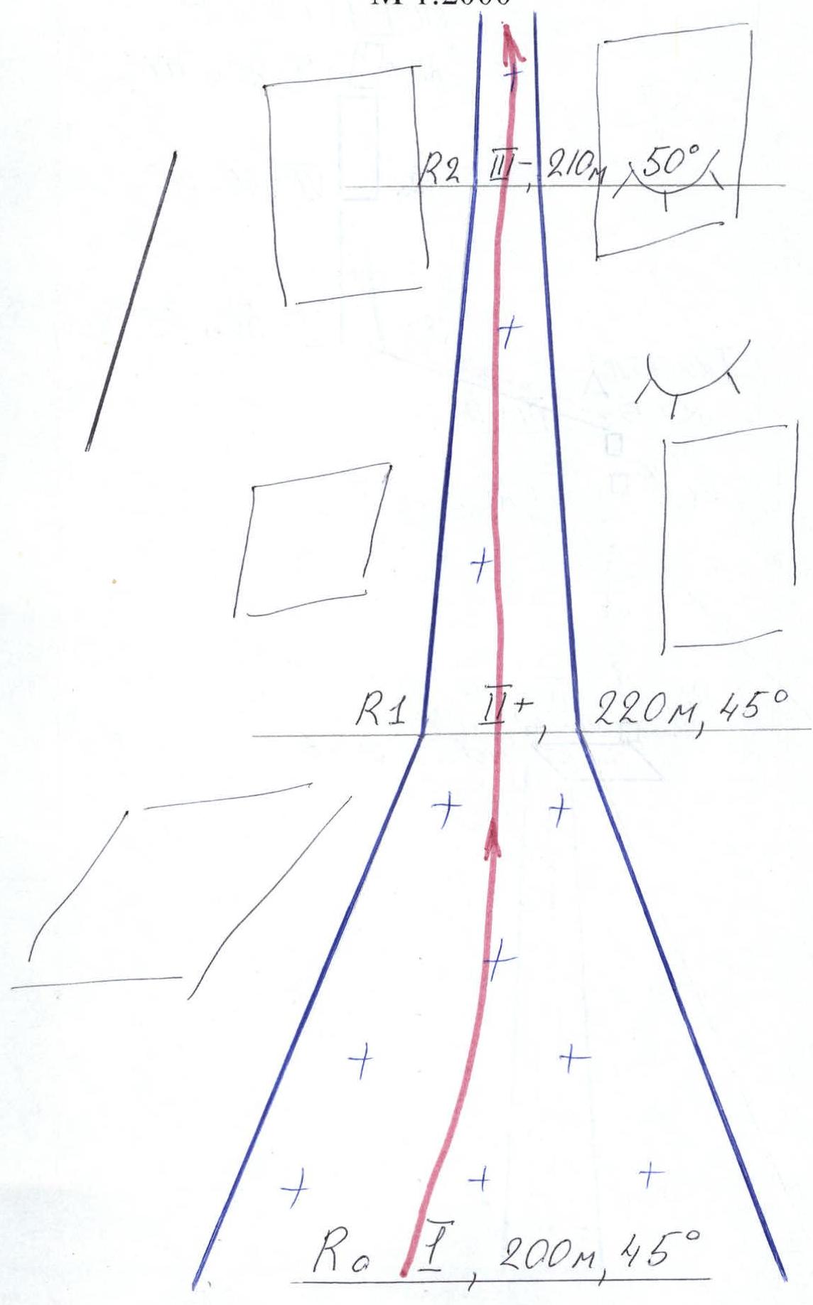
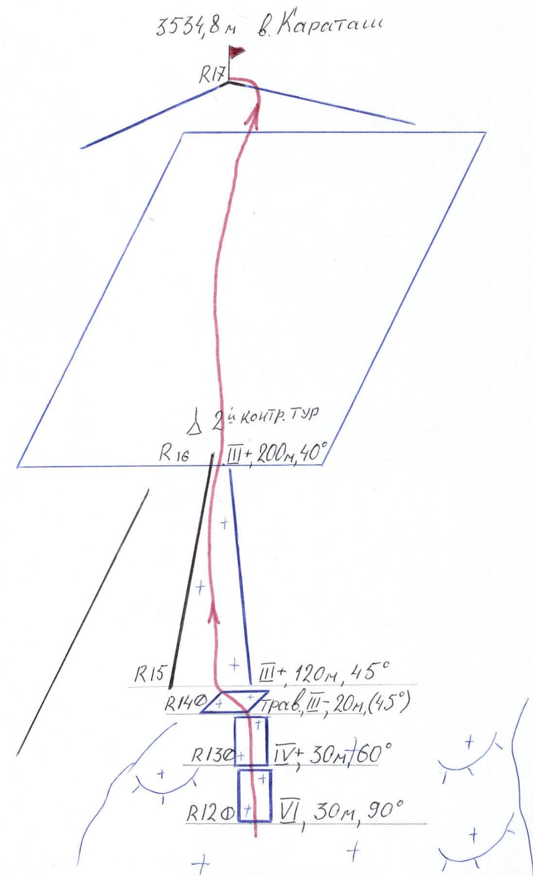
Sheet 8
Route diagram in UIAA symbols. Scale 1:2000
Sheet 8a (reverse)
Route diagram in symbols

Sheet 8a
Route diagram in symbols
Sheet 8a (reverse)
Route diagram in symbols
Sheet 9
Route description by sections
Section R0–R1: 200 m, 45°. Couloir debris cone. Simultaneous movement. Section R1–R2: 220 m, 45–50°. Wide couloir. Simultaneous movement from one rock niche to another, for insurance in case of ice fall from above. Section R2–R3: 210 m, 50°. Narrow couloir turning into a gully. Alternating movement. Section R3–R4: 30 m. Traverse left along a system of ledges and slabs with an overall steepness of 55–60°, avoiding a hazardous gully without niches, with accreted ice on "ram's foreheads" and avalanche-prone snow lenses on the gully's sides. Section R4–R5: 5 m, 85°. Rock wall, clearing with the use of 3 ITO. Total of 4 rock elements. VI category. Section R5–R6: 75 m, 50°. Destroyed slope, IV category, 5 pitons, outcrops, transverse movement. Slate rocks, crumbling. Section R6–R7: 30 m, 55° overall steepness and length. Two walls encountered, 5 and 7 m, 85°, VI category. 6 rock elements. Alternating movement until reaching the ridge. I control cairn. Section R7–R8: 90 m, 20°. Narrow ridge, III category, insurance via outcrops, simultaneous movement. Section R8–R9: 50 m, 65°. Accreted ice under the icefall, V category. Alternating movement, insurance via ice axe pitons. Section R9–R10: 40 m, 90°. Glacier ice, ice screws, alternating movement, VI category. Section R10–R11: 20 m, 100°. Overhanging ice, ice screws, Fifi hooks, alternating movement. Section R11–R12: 30 m, 70°. Flattening in the middle of the icefall's fracture. Section R12–R13: 30 m, 90°. Same insurance. Section R13–R14: 30 m, 60°. Transition to the icefall's roof, ice screws, alternating movement. Section R14–R15: 20 m. Traverse left into the rancluift, avoiding the icefall's roof snow slabs. Section R15–R16: 120 m, 45°. Rantuift, deep snow, insurance via rock elements, simultaneous movement. Exit to "Promezhnost'" — II control cairn. Section R16–R17: 200 m, 40°. Snow-ice field with numerous crevasses, bypassing the "button" on the right. Pitons insurance, simultaneous movement, exit to the ridge 10 m to the right of the summit.
Descent via 2A category route.
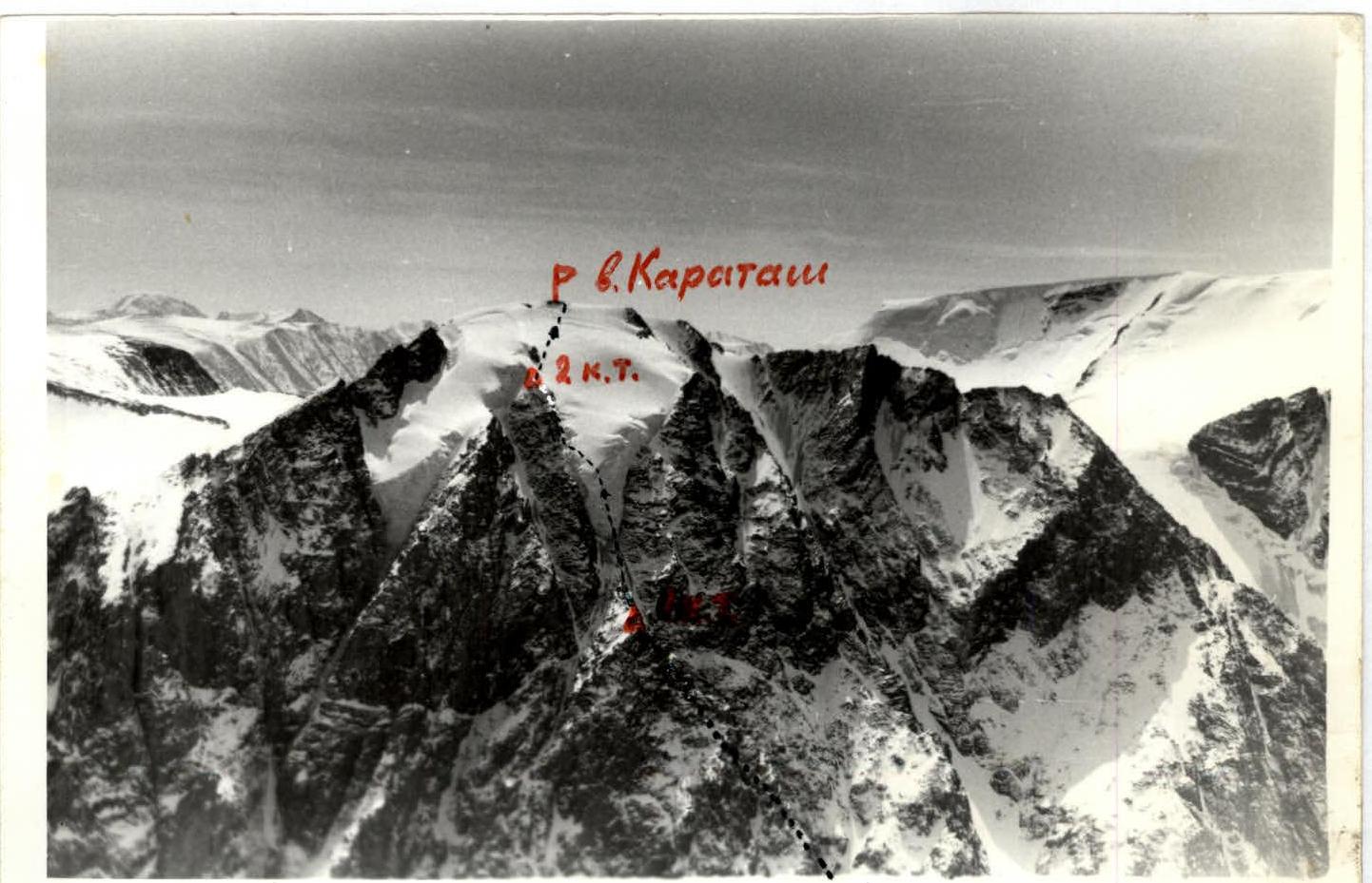
Sheet 11
Technical photo of the route
October 1981, camera "Smena-8M", lens from peak Kzyl-Tash.
Sheet 12
Section R2–R4. View from above from section R11–R12.
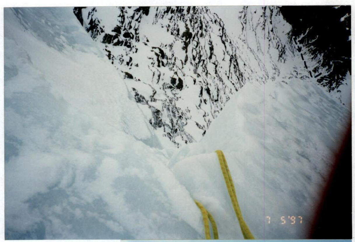
Section R7–R13. View from below from I control cairn.
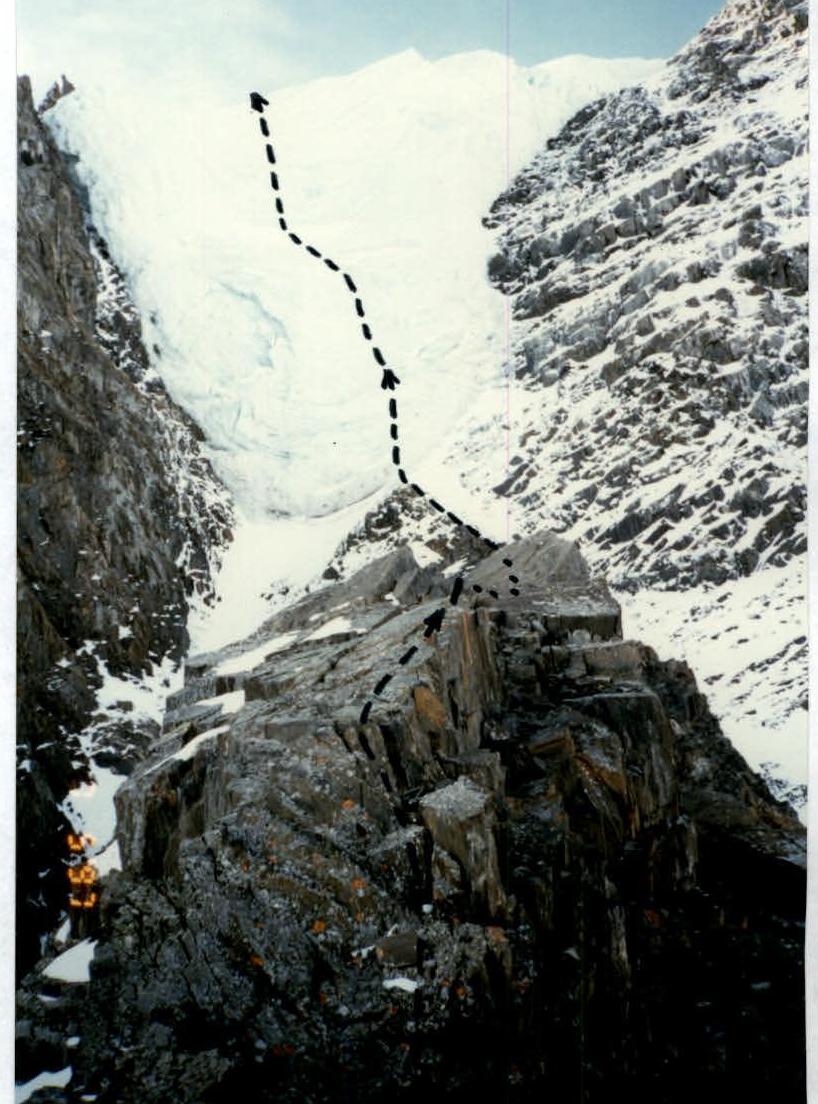
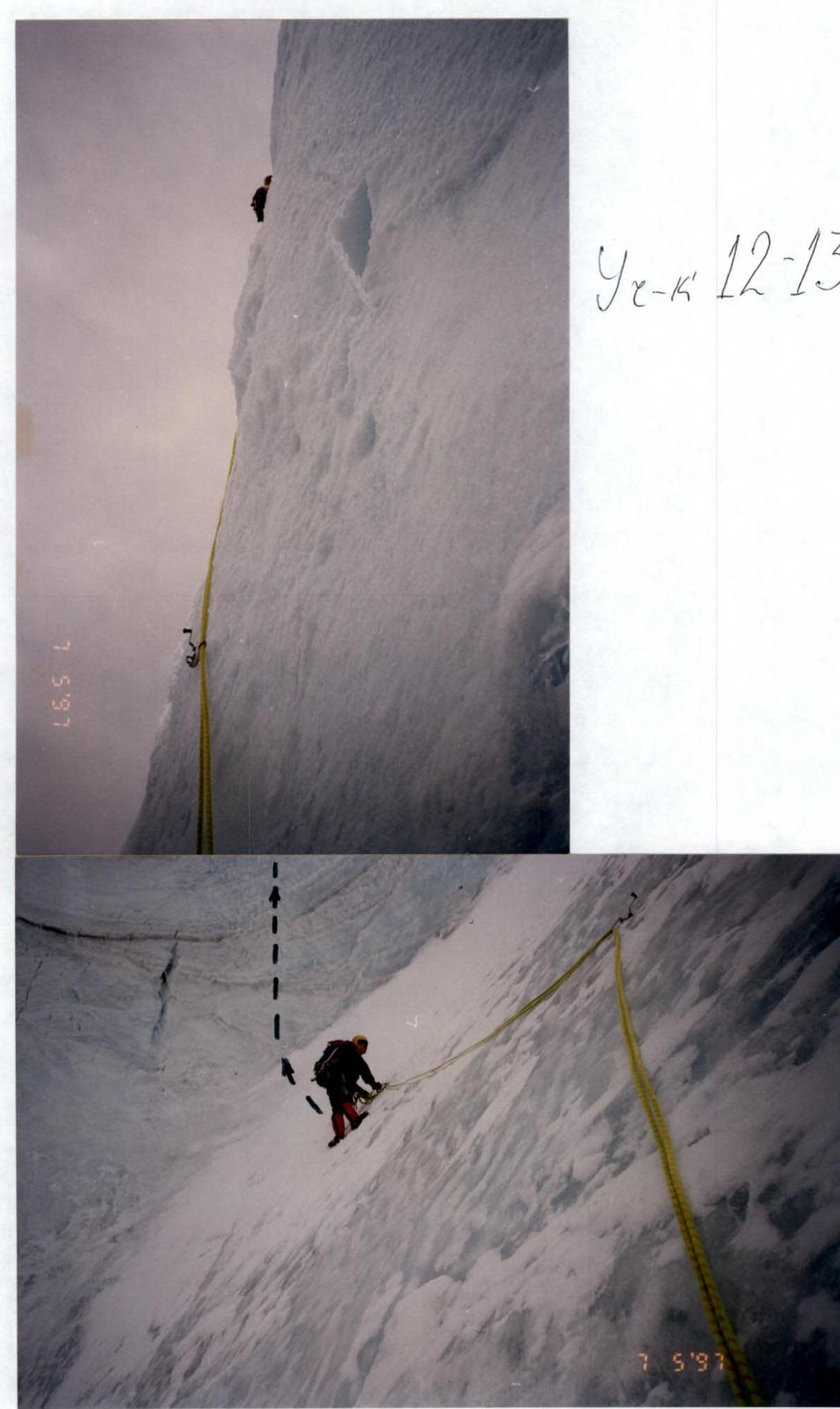
Sheet 13
Section R12–R13. Section R11–R12.
Sheet 14
Section R7. I control cairn. Section R15.


