Ascent Log
-
Altai, Severo-Chuyskie Belki ridge, Aktru gorge, section 1.
-
Karatash peak, 3535 m, via the left part of the North face.
-
Proposed category: 4B, first ascent.
-
Route type: rock.
-
Height difference: 1100 m, length: 2500 m, average steepness of the main part: 60°.
-
Pitons used: 50 rock and nut.
-
Climbing hours: 18, days: 2.
-
Leader: Afanasyev A.E., Master of Sports
Participants:
- Zyatkov N.A., 1st sports category
- Salin A.V., 1st sports category
-
Coach: Afanasyev A.E.
-
Departure for the route: August 8, 1991, summit: August 9, 1998, return: August 9, 1998.
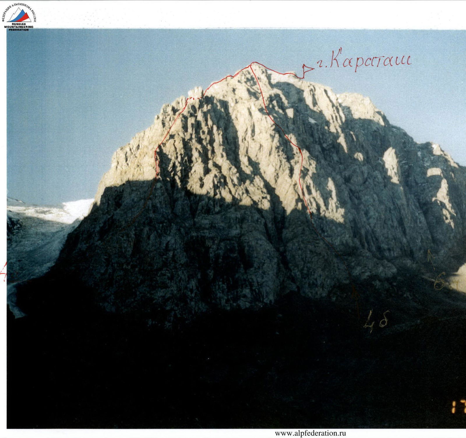
Description of the ascent route to Karatash 3535 m via the left counterfort of the North face, category 4B.
Access to the route: from Kedrovy Island at the confluence of the Bolshaya and Malaya Aktru rivers. Up the trail along the Bolshaya Aktru river to the bridge over the river in the upper floodplain, 30 minutes walk. Then:
- Left up to the black cliffs of the left part of the North face of Karatash peak, resembling three "irons",
- Above which a gray wall in the shape of an open palm rises. The route starts along the gully with loose rocks between the right and middle "irons".
Section R0–R1: 120 m, 45°, 2. Loose rocks. Better to go unroped. Section R1–R2: 50 m, 60°, 4. Inner corner. Section R2–R3: 20 m, 80°, 5. Loose wall. Move left around the corner to a chimney. Section R3–R4: 40 m, 80°, 5. Up the right edge of the chimney. Section R4–R5: 40 m, 85°, 5. Straight up the wall. Section R5–R6: 80 m, 60°, 4. Inner corner from left to right. Section R6–R7: 90 m, 50°, 3. Series of ledges up to the right. Reach the "palm" summit. Control point. Section R7–R8: 60 m, 55°, 3. Moderately difficult rocks, straight up. Section R8–R9: 20 m, 45°, 2. Steep ledge. Section R9–R10: 120 m, 50°, 3. Large rock faults, from right to left. Section R10–R11: 100 m, 45°, 2. Ledges and loose rocks. Section R11–R12: 150 m, 50°, 3. Medium rocks, exit to the ridge of the 3A and 4A category routes. Section R12–R13: 800 m, 30°, 2. Loose rocks, follow the ridge and left of the ridge with protection through outcrops, sometimes using pitons. Reach the last rock buttress before the summit glacier "Tronov's Pants". Section R13–R14: 200 m, 30°, 3. Sharp ice ridge, first half with steepness up to 45°. Protection with ice screws. Reach the summit.
Descent via the 2A category route along the Maly Aktru glacier.
Karatash 3535 m via the left counterfort, category 4B.
| Rock and nut | Ice | Section | Difficulty | Length | Steepness |
|---|---|---|---|---|---|
| R14 | |||||
 | |||||
| 3 | 2 | R13 | 3 | 200 m | 30° |
 | |||||
| 2 | R12 | 2 | 800 m | 30° | |
 | |||||
| 5 | R11 | 3 | 150 m | 50° | |
| Rock and nut | Ice | Section | Difficulty | Length | Steepness |
|---|---|---|---|---|---|
| 4 | R3 | 5 | 40 m | 80° | |
| 1 | R2 | 5 | 20 m | 80° | |
| 3 | R1 | 4 | 50 m | 50° | |
| R0 | 2 | 120 m | 45° | ||
| Total: | |||||
| 41 | 3 | ||||
| 3 | R10 | 2 | 100 m | 45° | |
| 5 | R9 | 3 | 120 m | 50° | |
| 3 | R8 | 2 | 80 m | 50° | |
| R7 | 3 | 20 m | 45° | ||
| 5 | R6 | 3 | 90 m | 50° | |
| 4 | R5 | 4 | 80 m | 60° | |
| 7 | R4 | 5 | 40 m | 85° |
3535 PZKhapatam