54 17
Ascent
To the peak of Zelinsky via the eastern counterfort of the northern ridge (approximately route 4A category of difficulty). Completed by a group of climbers from the Altai Regional Federation of Alpinism expedition.
Group leader — A.A. Parshennikov. 2. V.S. Bunyaeva. 3. N.A. Kuznetsov. 4. L.I. Salmashkov. 1000 m, 50°, 18 rock pitches, 16 hours.
INTRODUCTION
The Central Altai is located in the most elevated part of the Altai Mountains and is characterized by a high contrast of landscapes; almost all types of mid-mountain and high-mountain relief are found here, and modern glaciation is developed (more than 30% of all Altai glaciers are concentrated here).
The most typical landscape of the Central Altai is the alpine highlands, the formation of which is associated with modern glaciation.
Mineralogical composition of rocks:
- shales
- sandstones
- tuffs
- granites.
The climate is diverse. Annual precipitation is 1500–2500 mm, with most of it falling as snow. The North-Chuya Ridge is the most humid region.
The ridges of the Central Altai have a latitudinal or near-latitudinal direction:
- Katunsky
- North- and South-Chuya
- Terekta
- others.
The ridges are peak-shaped, with snow-covered, glacier-topped peaks, and steep, rugged slopes. The highest point of the Central Altai is Mount Belukha, with a height of 4506 m. The highest point in the North-Chuya Ridge is Mount Maasheybash, with a height of 4173 m.
The 1977 Altai Alpinist Expedition chose the North-Chuya Ridge area for ascents, and this was the third Altai expedition to this area in recent years. The area is relatively accessible and has many unclimbed routes.
The base camp was set up on the shore of Lake Srednyaya Shavda. The approaches to the routes take 2–3 hours.
TABLE 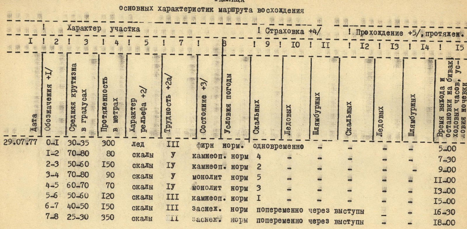
ROUTE DESCRIPTION
Peak Zelinsky is located in the southwestern part of the North-Chuya Ridge. The peak has several ridges: our group planned the route via the eastern counterfort of the northern ridge. The route is clearly visible from the base camp (Lake Srednyaya Shavda) and is logical — it is the closest route to the summit.
On July 29, 1977, at 3:00, we left the base camp (near Lake Srednyaya Shavda):
- Ascended via the left lateral moraine towards the Orbita pass.
- Before reaching the Orbita pass, a pronounced counterfort is visible. Our chosen route follows it.
- Approach to the counterfort via a snow-ice slope (average steepness 30–35°), then via a couloir — 2 ropes.
- The first bastion is climbed on the left via the couloir up to a chimney.
The walk from the base camp takes 2 hours.
The chimney is climbed with alternating piton belay (steepness about 80°, length — 2 ropes). Then, leftwards across moderately difficult snow-covered rocks (loose stones!) to a small wall composed of slabs. The wall is climbed directly upwards with alternating belay — 2–3 ropes.
Moderately difficult snow-covered rocks lead to the second bastion. A control cairn was built on the platform before the second bastion.
The bastion is climbed on the right:
- Difficult climbing
- Piton belay
Across severely broken snow-covered rocks to a small platform. This is the start of the key section of the route.
Across icy rocks of moderate difficulty leftwards — under a wall. A ledge about 30 cm wide. The wall is climbed rightwards and upwards. Steepness about 90°, almost no holds. Very difficult climbing. The wall is 2 ropes long.
Piton belay. After the wall — rightwards across severely broken snow-covered rocks (steepness 60–70°), to reach the northern ridge of the peak — 3 ropes. Difficulty lies in organizing belay:
- No cracks for piton placement.
- Belay is organized via protrusions.
A steep snow ascent leads to rock outcrops, which can be mistaken for the summit. A control cairn is built there. Along the ridge, across несложными rocks, to a second snow ascent (steepness 50–60°). Then along the ridge (simultaneous belay) to an ice-snow ascent, which leads to the summit.
Descent from the summit via the Zelinsky pass, category 2A difficulty.
The entire route takes 16–17 hours.
CONCLUSION ON ROUTE DIFFICULTY
The route was completed in 17 hours, with 13 hours spent on ascent and 4 hours on descent. 18 rock pitons were placed. The route is combined, short, but technically challenging. It requires good physical and technical preparation of participants.
The group assesses the route as category 4A difficulty.