Ascent Record for Peak GEPi-KUT, 3450 m, Category 3B
- Mountainous Altai, Severo-Chuysky Ridge, eastern spur of the main ridge between Maashey (Mazhoy, Maasheyul) gorge and Shavla River gorge.
- Peak GEPi-KUT, 3450 m, via the Western Ridge,
- Proposed — Category 3B complexity, first ascent.
- Route type — rock.
- Route elevation gain: 850 m (by aneroid barometer).
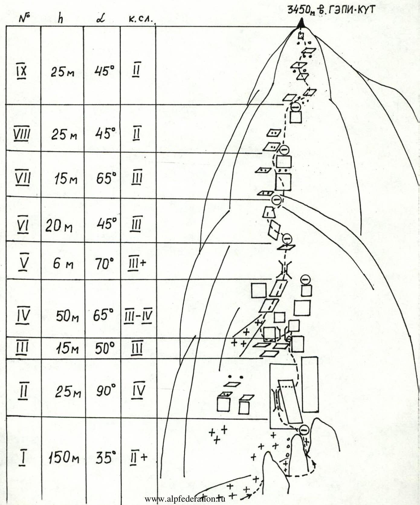
Route length: 330 m. Section lengths:
- Category 2 complexity — 200 m;
- Category 3 complexity — 81 m;
- Category 4 complexity — 50 m. Average steepness of the main route section — 45.5°
- Pitons left on the route — none.
Piton usage on the route — 8 chocks, 5 pitons, 3 slings.
- Team's total climbing hours: 10 h 00 min.
- Team leader: Yury A. Ermolaev, Candidate Master of Sports.
Team members:
- V.A. Baranov, 1st sports category;
- A.A. Sorin, 3rd sports category;
- A.V. Konovalov, 3rd sports category.
- Coach: Viktor I. Khan, Candidate Master of Sports.
- Approach to the route: 06:30, August 12, 2002.
Reached the summit: 12:30. Returned to base camp: 16:30.
East of the Katunsky Ridge, beyond the Argut River valley, lies the Severo-Chuysky Ridge. It stretches 140 km from northwest to southeast, with a width of 50 km in its western part, gradually narrowing to 20–25 km towards the east. The southern and southeastern boundaries of the area are defined by the valleys of the Karagem and Chagan-Uzun rivers. The ridge reaches its highest elevation in its central part, known as the Bish-Iirdu mountain node, where the main glaciation of the ridge is concentrated. The average height of the ridge here is about 3600 m, with several peaks exceeding 4000 m:
- Maashey-bashi — 4173 m
- Akturu — 4075 m
The ridge's passes vary, but share a common trait — the northern and northeastern slopes are steeper, with higher ascents. Pass categories reach up to 3B, with the most serious passes being snow and ice type. Snow line elevation:
- On northern slopes — around 2900 m
- On southern slopes — 3100 m and higher.
The ridge's orography is complex, comprising several roughly parallel ridges with a general west-to-east orientation:
- Chuysky
- Shavlinsky
- Karagemsky
The Chuysky Ridge is located between the Chuya and Shavla rivers, stretching 60 km east-west from the confluence of Chuya and Katun to the Eshtykol plateau. The ridge's heights increase from west to east, with the highest point being 2925 m. Many river valleys and the watershed have trails. The watershed is partially swampy.
The Shavlinsky Ridge is situated between the Shavla and Yungur valleys. At Argut, its height is around 2500 m, rising towards the east, and beyond the right tributary of Yungur — the Kurundy River — the ridge develops glaciation. Forests grow only in the river valleys. The most challenging passes and peaks are located in the eastern part of the ridge, which encircles the Shavlinsky mountain lakes in a horseshoe shape.
The average height of the Karagemsky Ridge, which forms the watershed between Yungur and Karagem, is 3400 m throughout its length. The ridge is covered with small glaciers, whose area increases towards the center of the node.
All ridges converge into a single node near the peaks Sказка (Fairy Tale) and Красавица (Beauty), located at the headwaters of the Shavla River. Further east, the ridge forms a complex system of ridges with developed valley glaciers and several northern and southern spurs, each 20–25 km long. The most significant glaciation is found in the upper reaches of the rivers:
- Akturu
- Maashey
- Shavla
and on the southeastern slopes — at the sources of the rivers:
- Dzhelo
- Karagem
Mountainous Altai, Severo-Chuysky Ridge, eastern spur of the main ridge between Maashey (Mazhoy, Maasheyul) gorge and Shavla River gorge.
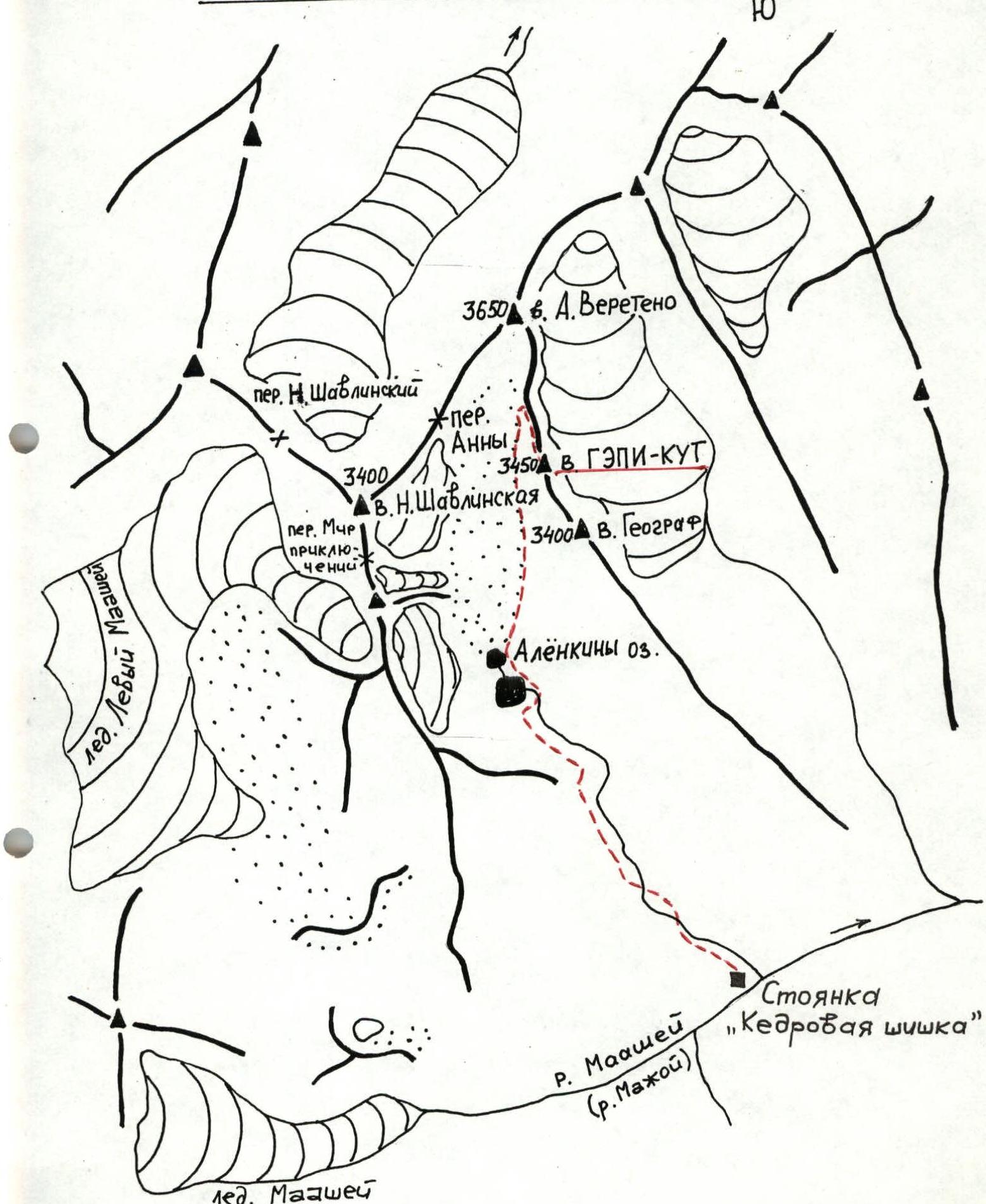
From the settlement of Chibit to the wooden bridge over the Chuya River at its confluence with the Maashey River, a dirt road follows the orographically left bank. The approach begins from the bridge, following a steep hairpin turn, then continuing on a dirt road to an old koshi (cattle station).
From the koshi, a good trail traverses along the left bank until the Maashey River turns towards its confluence with the Karakabak River. A log crossing is used at the confluence. This is a good spot for campsites. From the bridge — ~3 hours.
Ascend the orographically left bank of the Maashey River by trail to Maashey Lake (1.5–2 hours). Traverse around the lake to the right, and 30 minutes before reaching the glacier tongue, exit to a campsite known as "Kедровая шишка" (Cedar Cone).
At the campsite, a plaque on a large rock commemorates a deceased tourist named Alena…
Travel time:
- From the bridge to the campsite at the confluence of Karakabak and Maashey rivers — ~3 hours.
- From the campsite at the confluence to "Kедровая шишка" campsite — 3–4 hours.
From the campsite, ascend the orographically left tributary of the Maashey River to a waterfall. Traverse a steep, coarse scree and grassy slope to the left to reach a wide, middle scree slope, which ascends at a 45° angle along the riverbed towards the "pass" step on the slope. Upon reaching the top, the river valley opens up into a wide, even plateau. The grassy slopes and riverbed banks are densely overgrown with polar birch ("ertnika", "chiroy"), and many areas are swampy. Movement is challenging. The riverbed has branching streams, with many seepages and spring outlets. It's better to cross the riverbed to the left and follow a frequently disappearing trail on the right bank. Pass by large stones at the "gates," traversing upwards to the right, and exit via "ram's foreheads" steps to "Alenka's" lakes — two lakes. The lakes are connected and situated between the moraine and the barrier ("ram's foreheads"), and between the northern scree slopes and the southern swampy and grassy slopes of the gorge. Traverse around the lakes via rocks and the swampy shore to the right. Beyond the first lake, there's a characteristic hill-rock with a cairn on top. A plaque is also fixed on a rock in the lower part, commemorating the deceased tourist Alena… It's better to set up camp further upstream along the stream. From "Kедровая шишка" campsite to the lakes — 2–2.5 hours.
Route Map
Route Description
Peak GEPi-KUT, 3450 m, Category 3B (approximately), via the Western Ridge, first ascent
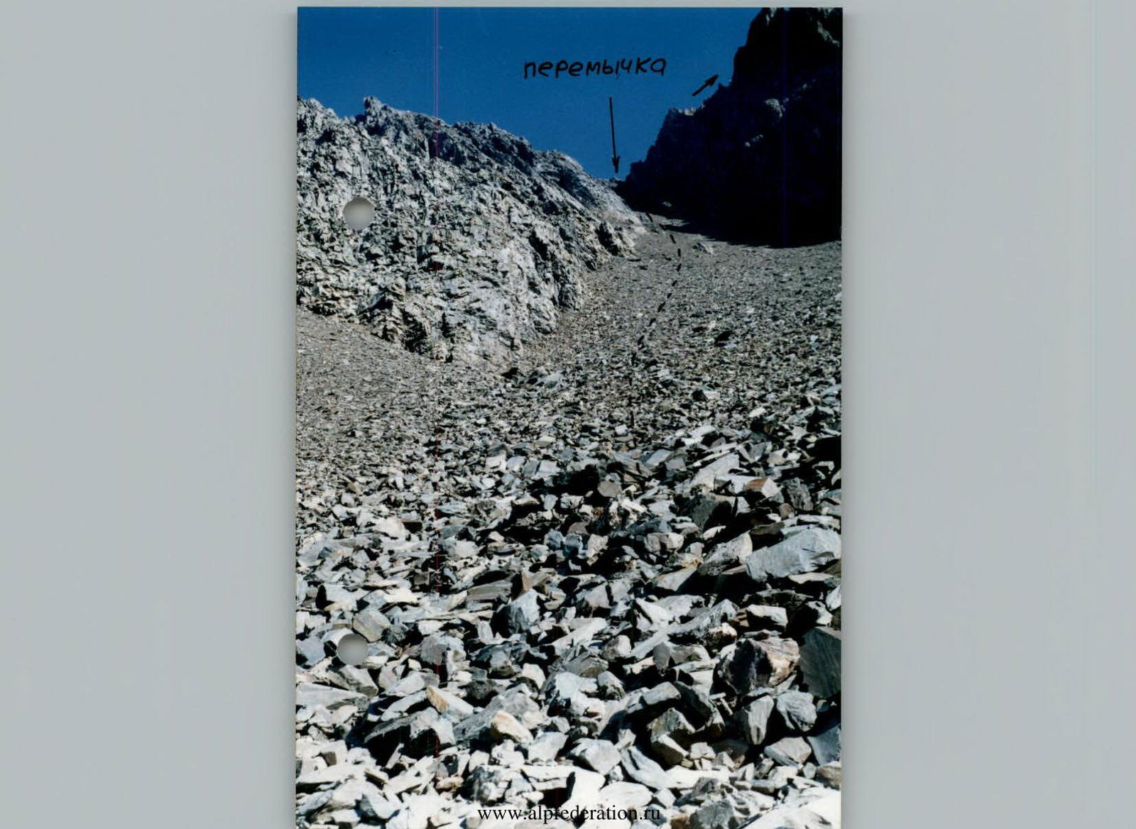
From the forward camp near "Alenka's lakes," move upwards, following the left bank of the 1st Lateral Moraine ridge, to the 2nd moraine ridge. Traverse around the 2nd moraine ridge to the right, and exit via a dry riverbed (along the depression between the moraine ridge and the scree slope) onto the crest of the moraine ridge (cairns are set along the crest). Follow the crest to a wide scree couloir.
The couloir is straightforward, with medium scree and rock outcrops in the lower part, forming a wide delta descending to the moraine. The upper part, as well as the right and left sides of the couloir, consists of broken rocks (rockfall hazard). The couloir is 350 m long, with a steepness of (40–45)°. The couloir ends at a col between two peaks.
From the col, proceed along the Western Ridge. The northern slope of the ridge, from the col to the wall, is icy, while the southern slope is rocky and scree-covered, steeply dropping into the gorge below. On the ridge, starting from the col, there are three gendarmes:
- The first is bypassed on the left via ice with simultaneous protection.
- The second is traversed on the right via scree-covered ledges. Caution: broken rocks, many "live" stones.
- The third is bypassed on the left via ice with simultaneous protection.
The ascent leads to an overhanging gendarme — a ledge with good cover. A separate, high rock is separated by a narrow crevice from the wall. It's bypassed on the left and via an inclined inner corner; exit is made via a narrow ledge at the top of the rock to the right. From the rock, transition is made to the wall. Using a wide crack on the wall, ascend upwards-left onto inclined slabs. Protection is piton-based, alternating.
Via an inner corner and ledges, traverse left onto overhanging walls and exit into a rocky couloir via inclined ledges. The lower part is icy; the upper part is a wall-ridge. Enter an inner corner to the right via inclined slabs, then onto the ridge and a wide ledge (good belay spot).
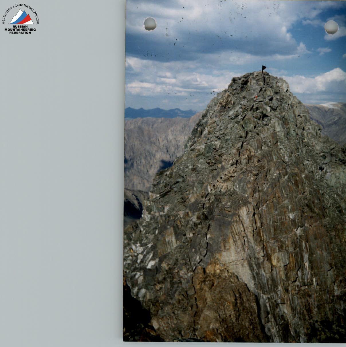
From the ledge, traverse left onto an inclined slab to the ridge, then, after passing a characteristic sharp rock head-on, exit onto a narrow scree col. Protection is alternating. From the col, two vertical walls on the ridge are traversed with alternating protection. Then, via a broken ridge, bypassing rocks to the left and right, exit onto the pre-summit ridge with broken slabs and the summit area. A cairn is set on the summit, and a memorial plaque is fixed.
Descent is made via the ascent route to the col with rope retrieval (it's better to go directly along the ridge) and then down the scree couloir to the moraine.
Total ascent time from the col is 2–3 hours, from the campsite to the couloir — 2 hours, to the col — 1 hour. Elevation gain is 200 m from the col. Summit height is 3450 m. Category complexity is 3B, rock. Summit name is GEPi-KUT (Center).
Peak GEPi-KUT (3450 m)
Route Category 3B (rock) via the Western Ridge

View from the route to peak A. Vereteno, peak GEPi-KUT, and peak Geograf
Peak GEPi-KUT, 3450 m, Category 3B, via the Western Ridge. View from the opposite peak.
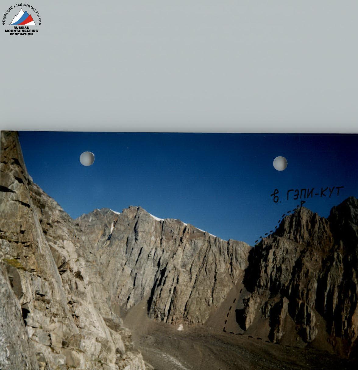 Peak GEPi-KUT, 3450 m, Category 3B via the Western Ridge.
Peak GEPi-KUT, 3450 m, Category 3B via the Western Ridge. Approach from the moraine to the col.