Ascent Passport
Region — Altai, Severo-Chuyskiy Ridge. Peak — L. N. Gumilev Peak, approx. 3700 m. Assumed category of difficulty — 3B. Height difference — 850 m. Route length — 1250 m. Average slope — 38°. Climbing hours — 9–10.
Group Composition
Turkevmch M. M. — Master of Sports of Russia, leader.
Kavunenko I. V. — 1st sports category.
Shumilov V. D. — Master of Sports.
Coach — Kavunenko V. D. — International Master of Sports.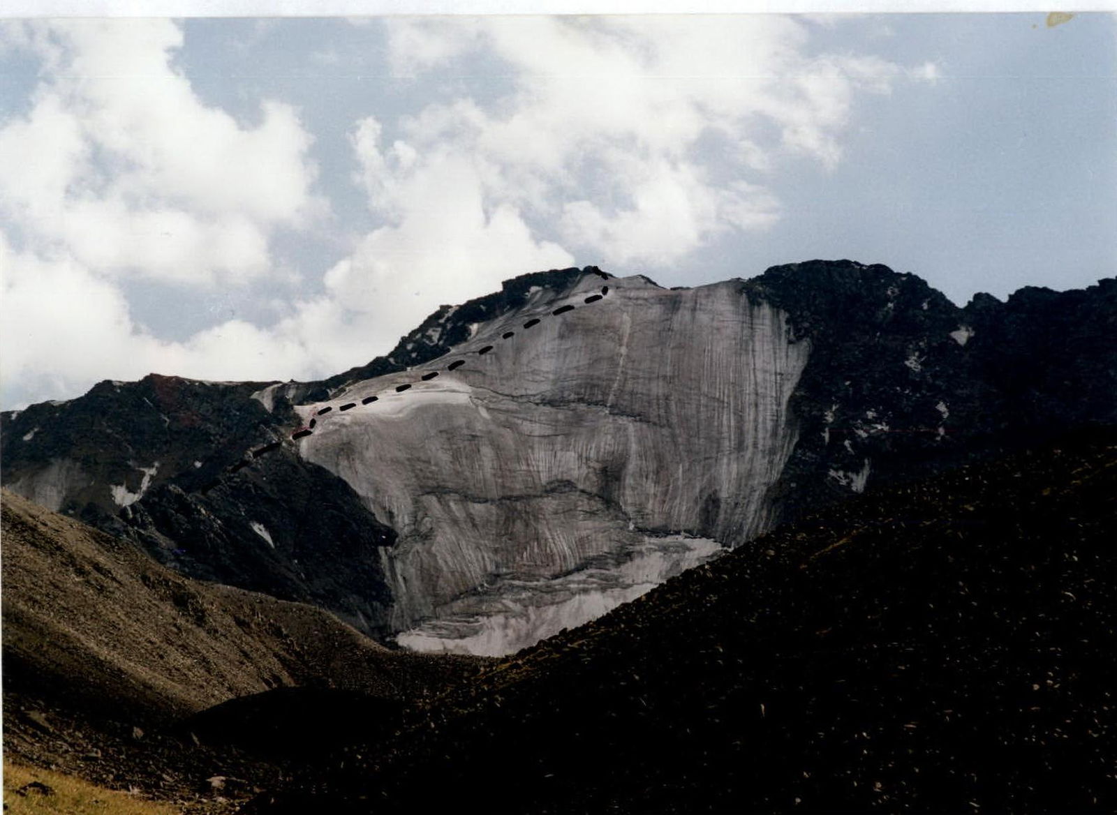
Approach
From the base camp at the confluence of the Maashey and Chuya rivers, follow the dirt road upstream to the first abandoned farm. Then cross the Maashey River by a bridge and continue on the road upstream. Upon reaching a flat area (a plateau with a lake), turn right from the road and proceed through the taiga along a barely noticeable, boggy trail uphill to a horizontal clearing. From the clearing, turn left and ascend through the taiga, entering the alpine zone below the slopes of PSK Peak. Leaving the slopes of PSK Peak with a triangulation marker to the right, walk for about 1.5–2 hours to a stream between two old moraines — this is the bivouac site. The landmark is the rightmost glacier in the Kurkure Ridge massif. From the base camp to the bivouac — 4.5–5.5 hours.
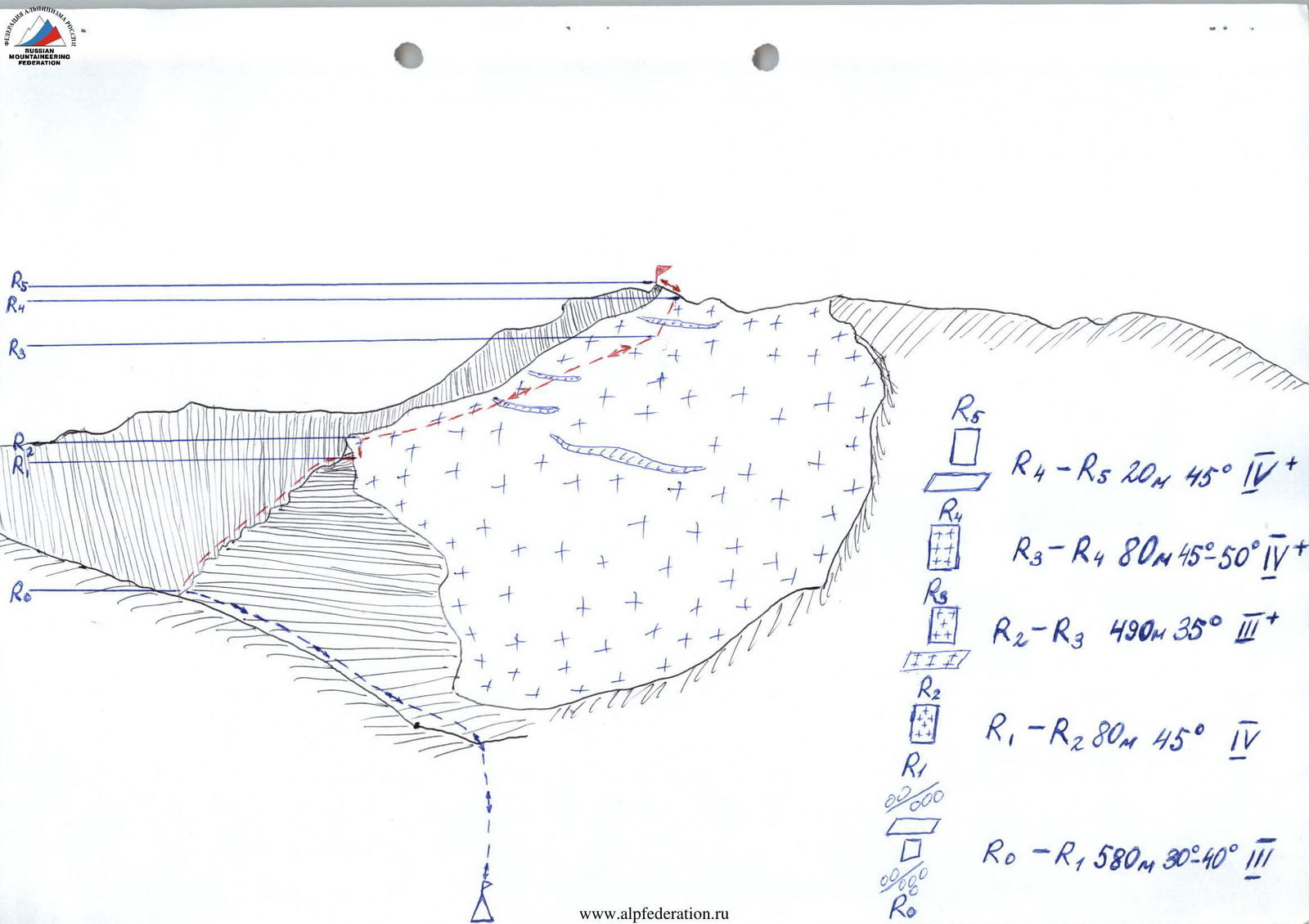
Route Description
From the bivouac, traverse between the moraines to the terminal moraine of the glacier. Ascend the terminal moraine and proceed left uphill to a lateral moraine, then ascend to the start of the NE ridge. Follow the ridge to a large gendarme (4–4.5 hours from the start of the ridge). Movement is in teams, both simultaneous and alternating.
Gendarmes are generally bypassed on the left. Rocks are heavily weathered! Rockfall hazard!
The large gendarme is bypassed on the right via an ice slope. Movement is alternating (45° slope). Protection via ice screws!
Above the large gendarme, the ridge dips, forming a convenient platform. From there, ascend the ice slope to the right, reaching the summit. Movement is alternating (35° slope). Crevasses!
Continue straight up to the summit tower. Protection via ice screws (up to 50° slope, 80 m).
Then ascend leftward up the rocks to the summit. Rocks are steep and monolithic; protection is necessary!
From the gendarme to the summit takes 5–5.5 hours.
Descent follows the ascent route:
- down the ice slope — 5–6 pitches;
- along the NE ridge — 2 pitches.
It is possible to deviate leftward in the lower half of the ridge onto the glacier?
From the summit to the bivouac takes 4–5 hours.
Recommended equipment for a group of 4:
- main rope — 2 × 40 m
- ice screws — 12
- ice axes — 4
- rappel slings — 4
- helmets — 4
- personal gear — 4 sets