
Ascent Log
to peak A. Vereteno, 3650 m, category 3B
-
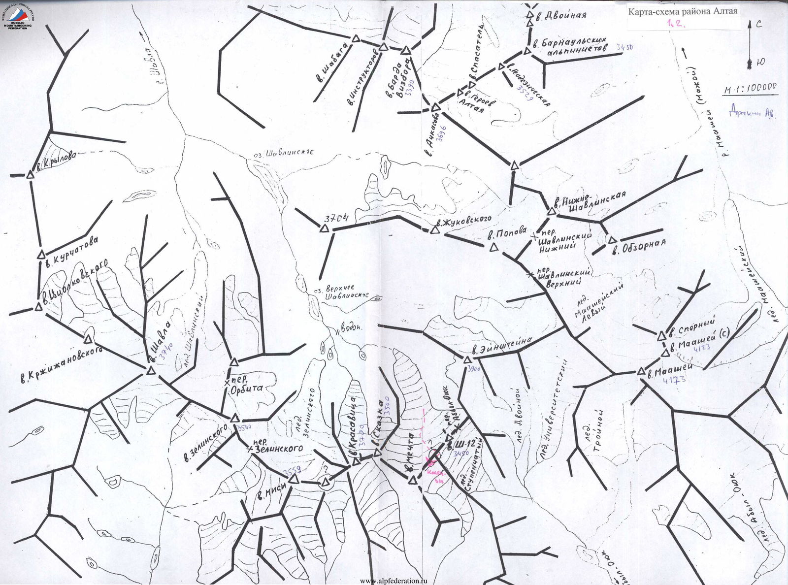
Gorny Altai, North-Chuya Range, eastern spur of the main ridge between the Maashay gorge (Mazhoy, Maasheul) and the Shavla River gorge.
-
Peak A. Vereteno, 3650 m, via the Northwest ridge.
-
Proposed category: 3B, first ascent.
-
Route type: ice and snow.
-
Route elevation gain: 1050 m (by aneroid barometer).
Route length: 510 m. Section lengths:
- Category 2 — 310 m
- Category 3 — 200 m
Average slope of the main route section — 43°.
-
Pitons left on the route — none.
Piton usage on the route — 12 ice screws.
-
Team's total climbing time: 10 hours 30 minutes.
-
Leader: Bekishev Mikhail Georgievich, 1st sports category.
Team members:
- Baranov V.A., 1st sports category
- Sorin A.A., 3rd sports category
- Konovalov A.V., 3rd sports category
-
Coach: Khan Viktor Irgonovich, Candidate Master of Sports.
-
Departure for the route: 6:30 AM, August 11, 2002.
Summit reached: 1:00 PM. Return to the forward base camp: 5:00 PM.
Description of the Climbing Area
East of the Katunsky Range, beyond the Argut River valley, lies the North-Chuya Range. It stretches from northwest to southeast for 140 km, with a width of 50 km in its western part, gradually narrowing to 20–25 km in the east. The southern and southeastern boundaries of the area are defined by the valleys of the Karagem and Chagan-Uzun rivers. The range reaches its highest elevation in its central part, known as the Bish-Iirdu mountain node, where the main glaciation of the range is concentrated. The average height of the range here is about 3600 m, with several peaks exceeding 4000 m (Maashey-bashi – 4173 m, Aktru – 4075 m).
The passes of the range are diverse but share a common characteristic — the northern and northeastern slopes of the passes are steeper, with higher ascents. The categories of the passes range up to 3B, with the most serious passes being snow and ice.
The snow line elevation:
- on northern slopes — about 2900 m
- on southern slopes — 3100 m and above.
The orography of the range is complex, consisting of several roughly parallel ridges with a general west-to-east direction — the Chuya, Shavla, and Karagem ridges. The Chuya Ridge is located between the Chuya and Shavla rivers, stretching for 60 km in a latitudinal direction from the confluence of the Chuya and Katun rivers to the Eshtykol plateau. The heights of the ridge increase from west to east, with the highest point being 2925 m. Many river valleys and the watershed have trails. The watershed is partly swampy.
The Shavla Ridge is situated between the Shavla and Yungur valleys. At Argut, its height is about 2500 m, rising to the east, and beyond the right tributary of Yungur, the Kurundy River, glaciation appears on the ridge. Forests grow only in the river valleys. The most challenging passes and peaks are located in the eastern part of the ridge, which horseshoe-shapedly encloses the Shavla mountain lakes.
The average height of the Karagem Ridge, which is the watershed between Yungur and Karagem, is 3400 m throughout its length. The ridge is covered with small glaciers, the area of which increases towards the center of the node.
All ridges converge into a single node in the area of the Sказка and Красавица peaks, located in the headwaters of the Shavla River. Further to the east, the ridge forms a complex system of spurs with developed valley glaciers and a number of northern and southern spurs, each 20–25 km long. The most significant glaciation is concentrated in:
- the upper reaches of the Aktru River
- the upper reaches of the Maashey River
- the upper reaches of the Shavla River
- the headwaters of the Jelo River (southeastern slopes)
- the headwaters of the Karagem River (southeastern slopes).
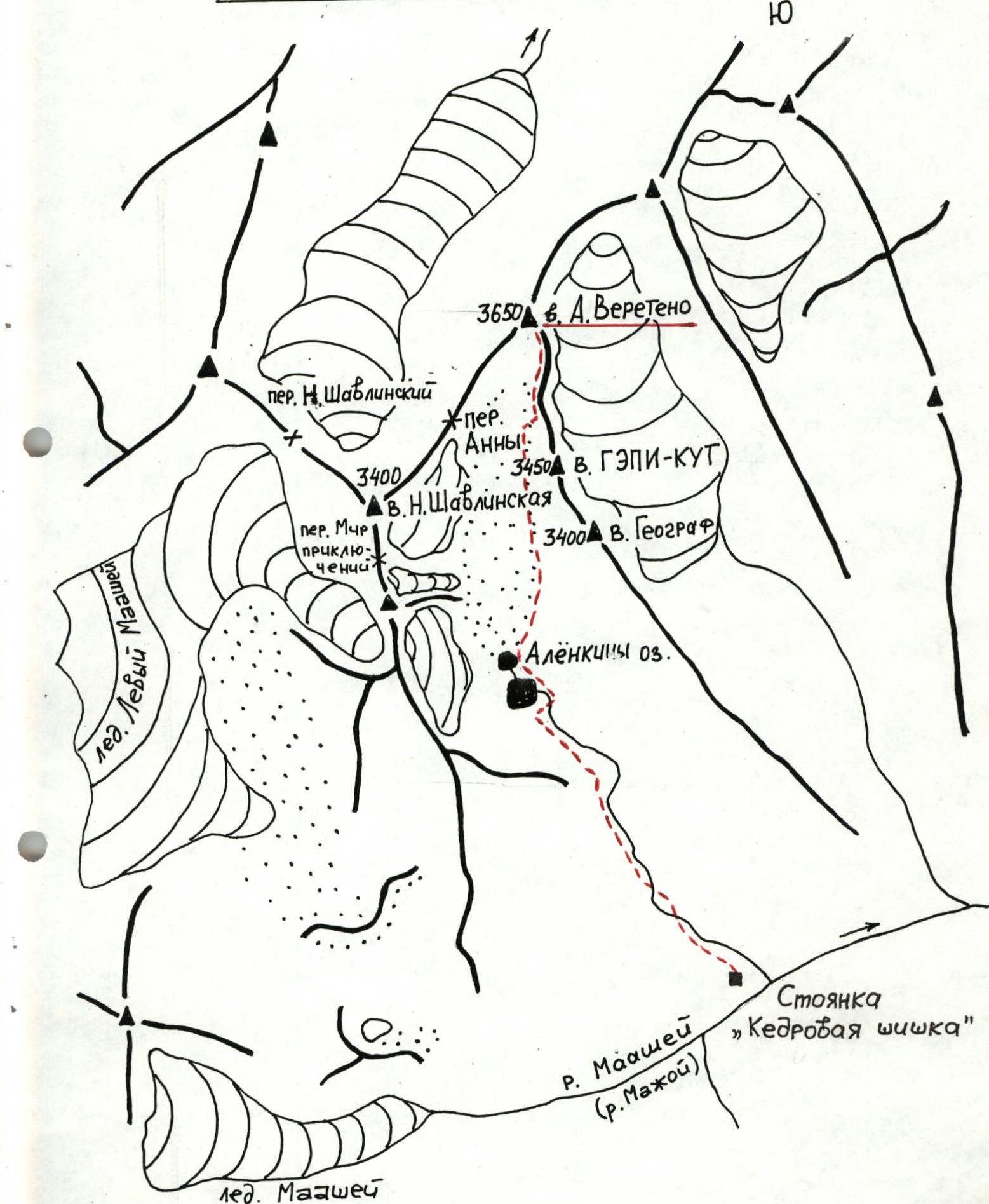
Approach to the Route to Peak A. Vereteno
Gorny Altai, North-Chuya Range, eastern spur of the main ridge between the Maashay gorge (Mazhoy, Maasheul) and the Shavla River gorge.
From the village of Chibit to the wooden bridge over the Chuya River at its confluence with the Maashey River, a dirt road follows the left bank. The approach begins from the bridge, following a steep hairpin turn, then continuing on a dirt road to an old cattle enclosure. From the enclosure, a good trail traverses along the left bank to the point where the Maashey River turns towards its confluence with the Karakabak River. Crossing is made on logs near the confluence. This is a good spot for campsites. From the bridge — ~3 hours. Climb along the left bank of the Maashey River via a trail to Maashey Lake (1.5–2 hours). Bypass the lake on the right, and 30 minutes before reaching the glacier tongue, exit to a campsite known as "Kedrovaya Shishka" (Cedar Cone). At the campsite, a plaque on a large stone commemorates a deceased tourist named Alena.
Travel time:
- From the bridge to the campsite at the confluence of the Karakabak and Maashey rivers — ~3 hours.
- From the campsite at the confluence to the "Kedrovaya Shishka" campsite — 3–4 hours.
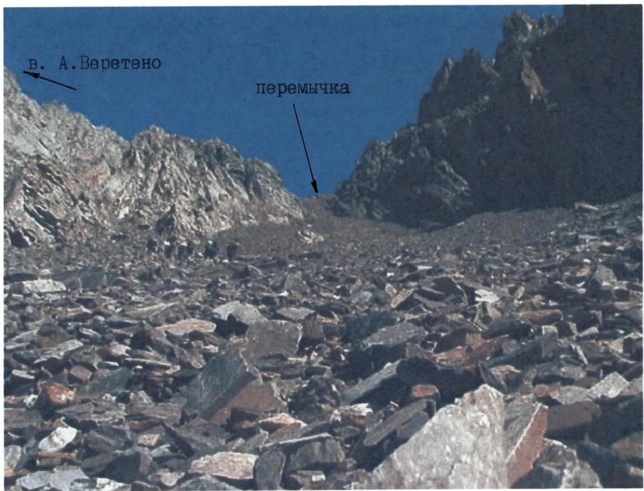
From the campsite, ascend along the left tributary of the Maashey River to a waterfall, and by traversing a steep, coarse scree and a grassy slope on the left, exit onto a broad, middle scree that ascends at a 45° angle along the riverbed towards the "pass" step of the slope. Upon reaching the top, the river valley opens up into a wide, even plateau. The grassy slopes and riverbed banks are densely overgrown with polar birch ("ertnik", "chira"), and many areas are swampy. Movement is hampered. The riverbed has branching streams, numerous seepages, and spring outlets. It's better to cross the riverbed to the left and follow a frequently disappearing trail on the right bank, passing by large stones at the "gate," then traverse upwards to the right, exiting via "ram's foreheads" steps to "Alenka's Lakes" — two lakes. The lakes are connected and situated between the moraine and the barrier ("ram's foreheads"), and between the northern scree slopes and the southern swampy and grassy slopes of the gorge. The lakes are bypassed on stones and along the swampy shore to the right. Beyond the first lake, there's a characteristic hill-stone with a cairn at its top. In the lower part, a plaque is also fixed on a stone in memory of the deceased tourist Alena. It's better to organize a campsite further upstream along the stream. From the "Kedrovaya Shishka" campsite to the lakes — 2–2.5 hours. Map of the climbing area.
Route Description
Peak A. Vereteno, 3650 m, category 3B (approximately), via the Northwest ridge, First ascent.
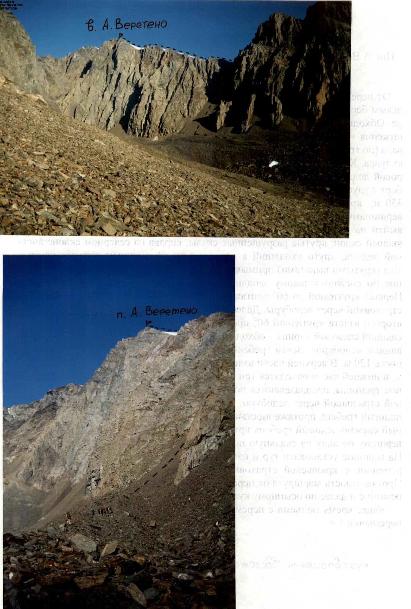
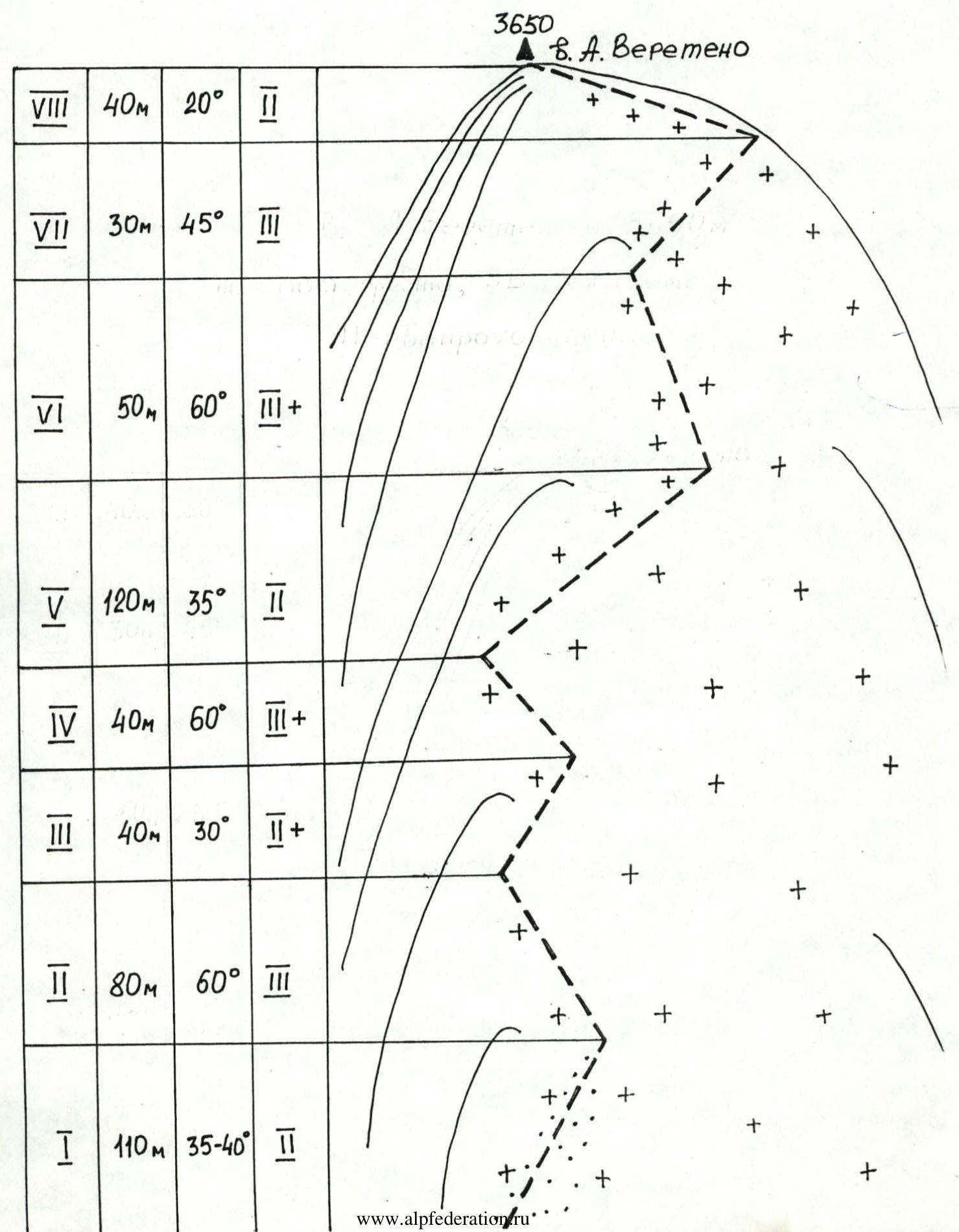
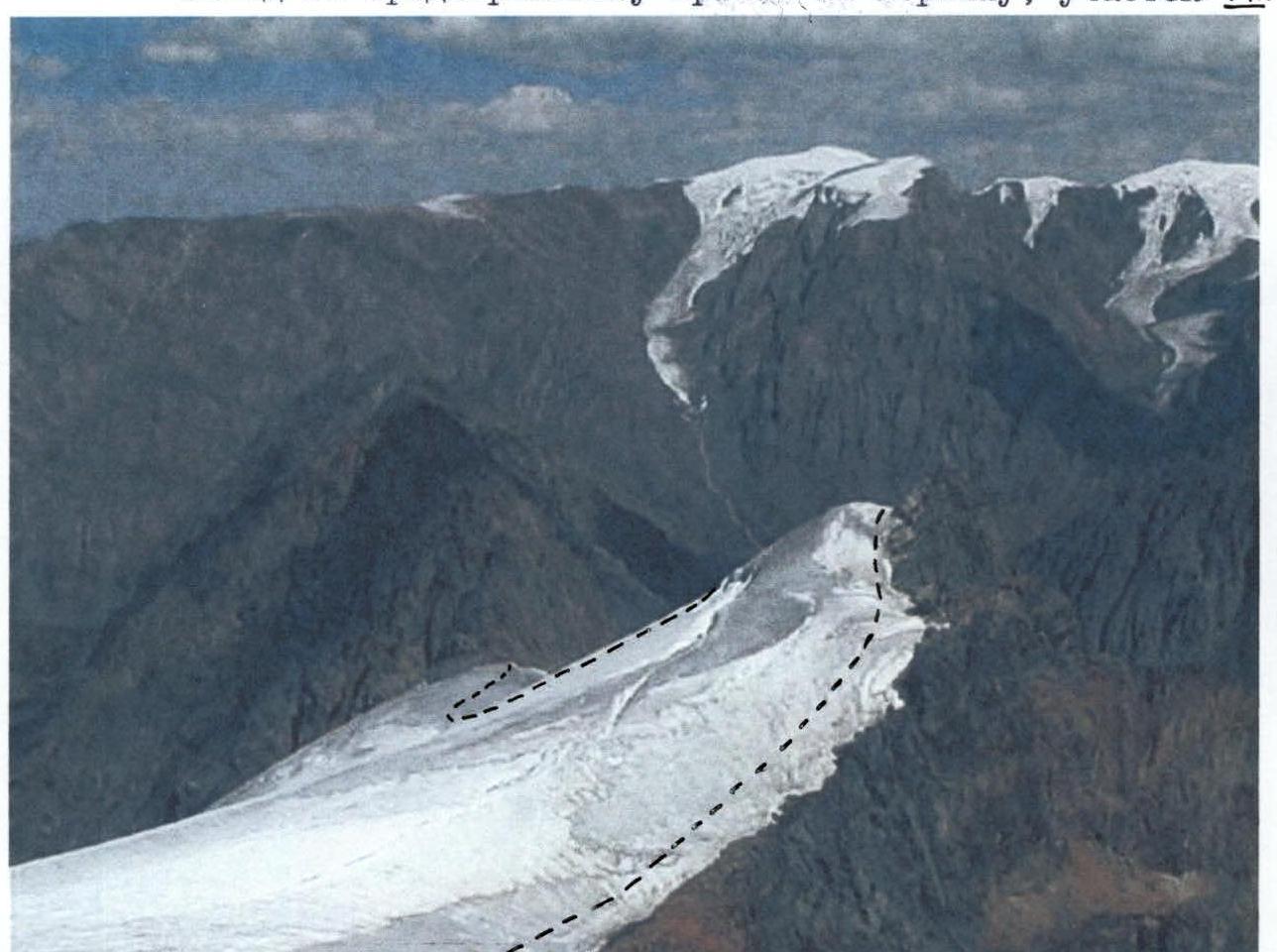
From the forward camp near "Alenka's Lakes," move upwards, orienting along the left bank alongside the 1st lateral moraine ridge to the 2nd moraine ridge. By passing the second moraine ridge on the right, exit via a dry riverbed (along the depression between the moraine ridge and the scree slope) onto the crest of the moraine ridge (cairns are set along the crest). Follow the crest to a broad scree couloir. The couloir is straightforward, with medium scree and patches in its lower part, descending in a broad delta to the moraine. The upper part, as well as the right and left sides of the couloir, are composed of destroyed rocks (rockfall hazard). The length of the couloir is 350 m, with a slope of 40–45°. The couloir ends at a saddle between two peaks. From the saddle, follow a scree ridge — 110 m, slope 35–40° — to exit onto a snow and ice ridge heading west. To the left is a southern slope with steep, destroyed rocks; to the right, on the northern slope, is a hanging glacier steeply descending into a parallel valley to "Alenka's Lakes." The ice (with steep outcrops) adjoins the rocks — requires special attention.
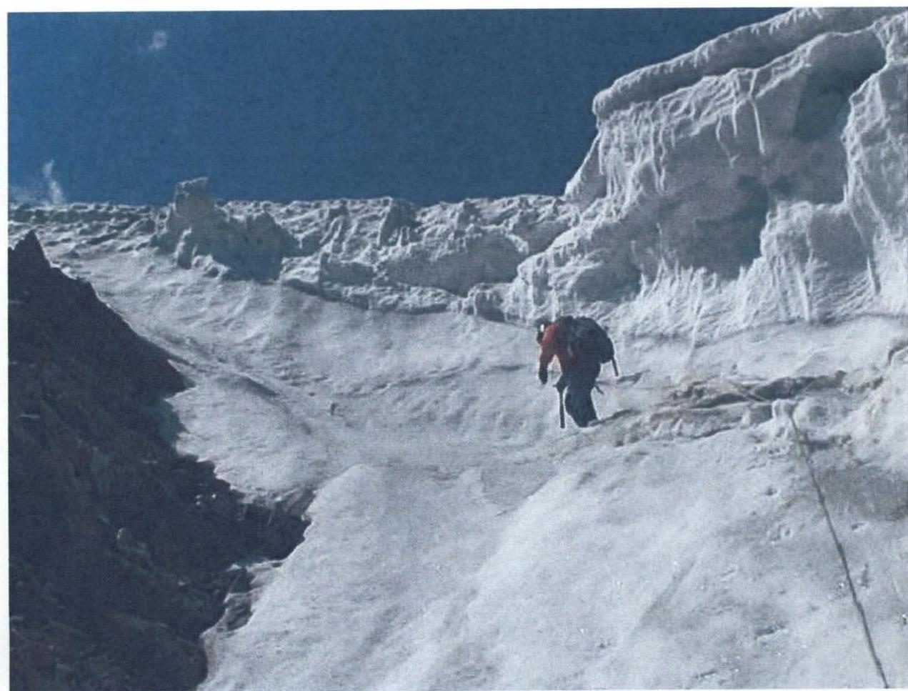
Movement along the snow and ice western ridge involves three ascents:
- The first ascent: slope up to 60°, length 80 m. Movement with alternating belay via ice screws.
- Then a flattening of 40 m, 30° to the next, second ascent, with a slope of 60°, length 40 m. In the upper part, there's an overhanging snow cornice; bypass it on the left. Belay is alternating using ice screws.
- Then the ridge flattens, heading to the right, length 120 m.
- In the upper part, there's an ascent with a slope up to 55–60°, length 50 m. In the lower part, there are three consecutive closed crevasses, overcome via snow bridges with careful alternating belay using ice screws.
- Between the second and third ascents — a broad, gentle ridge, length 150 m.
- The third ascent leads to the pre-summit snow and ice ridge, slope 45°, length 30 m.
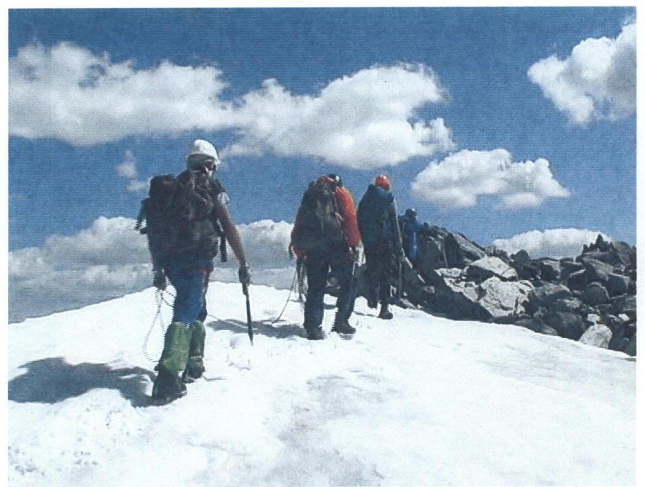
The summit is reached by traversing ice to a rocky, semi-destroyed area. Height 3650 m. At the summit, a cairn and a memorial plaque are installed. Movement on the route is alternating with piton belay, using ice screws, and is done in crampons. The route length from the saddle is 800 m. Descent is made via the ascent route to the saddle and then down the scree couloir to the moraine.
Total ascent time from the saddle — 3.5 hours, from the campsite to the couloir — 2 hours, to the saddle — 1 hour.
Ascent leader Bekishev M.G.
V. A. Vereteno, 3650 m
via the Eastern ridge, category 3B (combined). First ascent.
 V. A. Vereteno, 3650 m.
 V. A. Vereteno, 3650 m.
View from the moraine to the saddle.
V. A. Vereteno, 3650 m.
Exit onto the summit via the pre-summit ridge, section R8.
View from the summit to section R6.
Comments
Sign in to leave a comment