Ascent Passport
- Technical category.
- Altai, Katunsky ridge, Akkem valley.
- Korona Altaya peak 4170 m. Central part of the Eastern Wall.
- Route 6B (Afanasyev's route variation, 2002).
- Route height difference: 1120 m (wall base 3050 m – summit 4170 m). Route length about 1300 m (excluding the western plateau).
- Wall section length about 1100 m (height difference about 1000 m).
- Section length of 5th grade complexity ~490 m. Section length of 6th grade complexity ~275 m.
- Average route slope about 65° (foot – plateau ascent).
- Average wall section slope about 70°.
- Driven pitons (including for ITO):
- rock pitons and rock anchors 80/55;
- expansion bolts 2 (on bases); (skyhooks ~4 holes);
- protection elements (stoppers, eccentrics, friends) 200/155;
- ice screws 15/3.
- Team's travel hours ~148 h: Days: 17.
- Overnights: 17
- 1 – in a cave under the route;
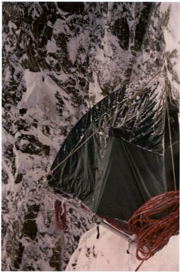
- 15 – on a platform on the wall;
- 1 – in a tent on the western plateau.
- Participants:
- Kirikov Alexander Vyacheslavovich – CMS (Tomsk);
- Oleinik Andrey Alexandrovich – CMS (Tomsk).
- Route start: February 17, 2006 (16:15). Summit: March 5, 2006 (9:00). Descent: March 5–6, 2006.
General photo of Korona Altaya peak (4170 m) (summer photo)
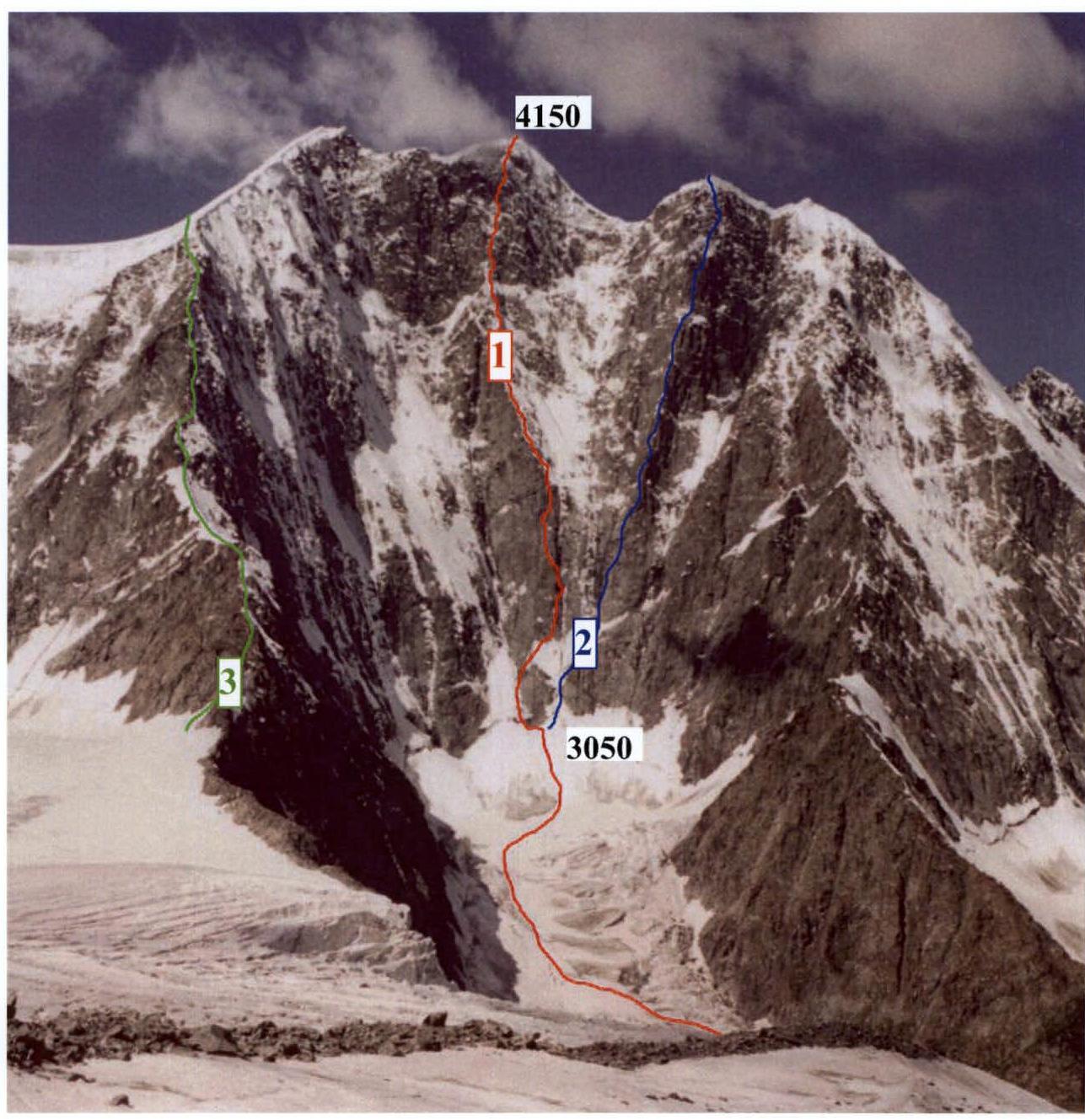
- Central part of the Eastern Wall 6A, A. Afanasyev, 2002 (February).
- Right part of the Eastern wall 6A, I. Altaysky-Gnoevsky, 1983.
- Left ridge 4A. Descent route.
Overview of the area, characteristics of the ascent object
Ak-Kem is an area in Altai. Katunsky ridge, Akkem valley. The area is home to the highest point in Altai — Mt. Belukha (4506 m). Due to several reasons, Akkem valley has become attractive to various pilgrims and believers. As a result, the area is crowded during the warm season. The Ak-Kem wall, closing the valley and crowned with twin-headed Belukha, is the largest in height difference in Altai (up to 1.5 km by "Butylka" – 5A), with absolute heights reaching over 4000 m. When viewed from the north, the wall is closed by two four-thousanders: Delone peak (left) and Korona Altaya peak (right). Both peaks have over kilometer-high walls with a slope above 60°, and routes of the highest difficulty categories pass through them. Harsh climatic conditions in the area (summer temperatures reach –20°C) have led to powerful glaciation both under the Ak-Kem wall and at the exit from the routes, and, as a result, many routes are highly avalanche- and rockfall-prone (especially during the warm season when the difference between day and night temperatures is maximum). Overall, the Ak-Kem wall and the area are very attractive for sport ascents.
In the cold season, the area is less visited. This is due to both weather conditions and remoteness from nearby settlements (more than 40 km on foot + a small pass). Until recently (2002), ascents of the highest category were not made in Ak-Kem or anywhere in Altai in winter. Although the area's sporting potential grows in winter. Many routes can be passed that are objectively dangerous in summer.
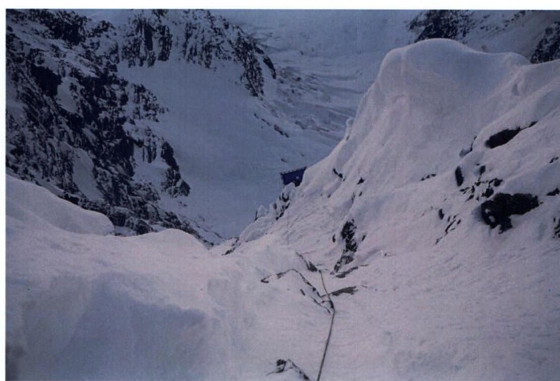
The Eastern wall of Korona Altaya peak is a very interesting object in sports terms. Good height difference and serious wall slope. At the same time, it is necessary to consider that the approaches to the wall are potentially dangerous. It is necessary to move through an ice-and-snow cirque, which can be entirely blocked by avalanches and icefalls coming from the wall and side ridges. In addition, the start of the routes is quite rockfall-prone. This is due to the eastern orientation of the wall (the sun is on it from early morning, warming up and starting to "bombard" the wall quite early in summer).
Until 2002, two routes passed directly through the right part of the wall:
- I. Altaysky, 1983, 6A cat. diff.;
- I. Plotnikov, 1997, 5B.
Despite the dangerous approach and lower wall section, Altaysky's route was passed multiple times. The main reason is that until 1999, it was the only "six" in Altai. (And it still is the safest of the classified "sixes" in Altai in summer).
The route through the center of the eastern wall, chosen by us for the championship, was first passed in February 2002 by an Altai team led by A. Afanasyev. Then the team took 15 days to pass the wall. The tactical plan included:
- living in a cave under the route;
- hanging the greater part of the wall with ropes;
- returning, setting up a camp, and re-hanging the ropes to the exit. When passing the route in a team of two, we naturally had to resort to a different tactics and ascent style. We planned to pass the wall faster than the first ascensionists and be done in about ten days. In reality, we spent 15 days on the wall. Moving faster was not possible due to the significant weight of the equipment. The first climber had to participate in carrying the load and the platform, which took a noticeable part of the winter day. Surprisingly, there are few traces of the first ascensionists on the wall (we noticed only one stopper, an expansion bolt, and a couple of holes for the platform in the upper part of the route). Since we did not see the first ascensionists' description, the route lines likely diverge, at least in the lower part. Most likely, Afanasyev's route variation was passed.
About the route. Three main blocks can be conditionally highlighted:
- The first bastion (11 ropes to R10) — quite steep, the lower part has poor relief, many blind cracks, everything is beaten by stones falling from above in summer, higher up it becomes richer because everything flies over it. The rocks are moderately destroyed.
- Inclined rock slabs and a ridge (23 ropes to R18). The relief is simpler, more snow, harder to protect.
- Summit tower (from R18 to the top). Again steeper, climbing is more difficult, but protection is okay.
The route is not recommended to be attempted in summer. It is significantly safer in winter. The main thing is to pass the cirque at the bottom normally (old-timers call the cirque "the toilet").
P.S. There is no photo of the route profile in the report. The route is deep in the cirque, and a normal profile can only be taken from the adjacent route to the right, I. Altaysky's route.
Ascent diagram on Korona Altaya 4170 m via the center of the Eastern wall in UIAA symbols
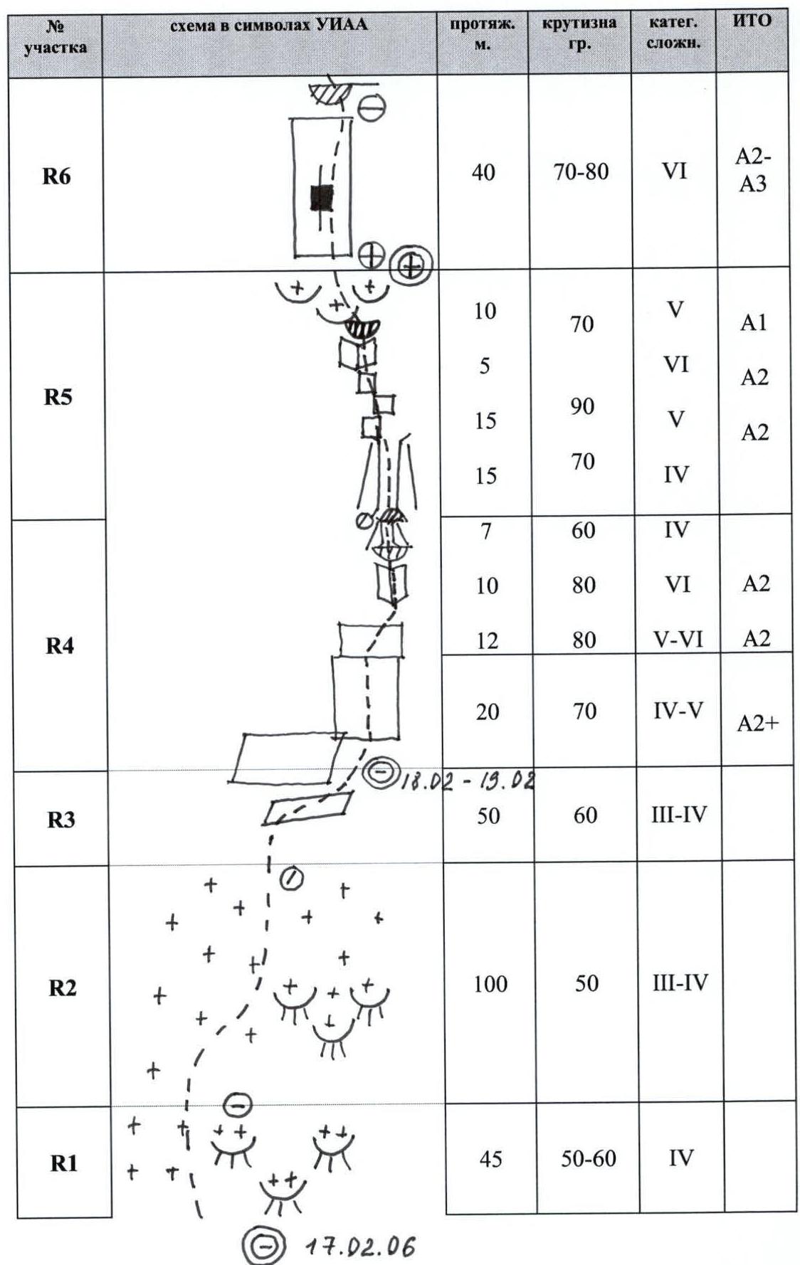
| № sect. | UIAA symbol diagram | Length, m | Slope, deg. | Cat. diff. | ITO |
|---|---|---|---|---|---|
| R10 |  | 25 5 5 10 | 60–70 80 | 4–5 6 6 | A3 A3 A4 |
| R9 |  | 20 20 | 70–80 85–90 | 5–6 6 | A2 A3 |
| R8 |  | 15 35 | 65–70 85–90 | 4–5 6 | A3 A4 |
| R7 |  | 10 8 10 10 15 7 | 60–70 60–70 90 70 90 | 4 4–5 6 5 6 5 | A2 A2 |
| № sect. | UIAA symbol diagram | Length, m | Slope, deg. | Cat. diff. | ITO |
|---|---|---|---|---|---|
| R14 |  | 90 | 60–80 | 5+–6 4–5 | A2 A1 |
| R13 | 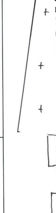 | 75 | 40–60 | 3–4 | |
| R12 |  | 80 15 45 | 60–70 65–75 60 | 4–5 | A1 |
| R11 |  | 45 | 70–80 | 4–5 |
| № sect. | UIAA symbol diagram | Length, m | Slope, deg. | Cat. diff. | ITO |
|---|---|---|---|---|---|
| R19 |  | 6 5 12 25 | 85 95 85 90–95 | 6 | A2–A3 A3 |
| R18 | 1.03 2.03 | 5 17 | 60–70 | 3 5–5+ | A1 |
| R17 | 10 25 10 | 70–75 70 80–90 | 5 5+ | A1 | |
| R16 |  | 10 15 25 | 70 60–70 50–60 | 4 | |
| R15 |  | 20 30 | 70 70 | 5 |
| № sect. | UIAA symbol diagram | Length, m | Slope, deg. | Cat. diff. | ITO |
|---|---|---|---|---|---|
| R26 |  | 1300 | |||
| R25 | 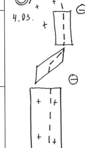 | 15 | 40–60 | 3–4 | |
| R24 |  | 15 15 50 | 90 30–40 | 5+–6 2–3 | |
| R23 | 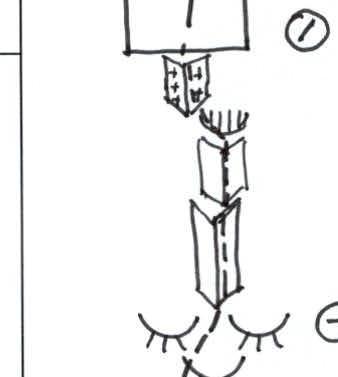 | 50 | 40–45 | 3–4 | |
| R22 |  | 15 10 20 50 | 60–70 90–95 80 50–60 | 4–5 6 5+ 4 | A3 A2 |
| R21 |  | 25 10 15 | 60–70 85–90 110–120 | 4–5 6 6 | A2–A3 A3–A4 |
Route description by sections
| № sect. | Date | № ropes | Description |
|---|---|---|---|
| R1 | 17.02 | 1 | Bergschrund 2.5 m wide, height difference about 4 m, then ice slope 50–60° ~45 m (4 cat. diff.). Movement along the left boundary of the lower rock island (sheep's foreheads). Protection on ice screws (2 screws on the station and 2 intermediate). |
| First overnight stay | Dug a small cave near the bergschrund. Lying overnight stay, comfortable. The cave under the route is a backup option in case of an emergency descent. | ||
| R2 | 18.02 | 2–3 | Movement up the firn, along the left boundary of the sheep's foreheads, then along a snowy slope 50°, 100 m to the rocks. On the foreheads and firn, it is problematic to organize protection. Lengthened the rope, base on the rocks (3–4 cat. diff.) (anchor, piton, friend, stopper, one screw — intermediate). |
| R3 | 4 | Traverse under the rocks along the firn and rocks to the right for 50 m (3–4 cat. diff.), 60°. Protection — pitons on the rock. | |
| R4 | 5 | Start of the main rock wall. 20 m worked out (4–5 cat. diff.) 70°. | |
| Second overnight stay | Under the rock wall, on a platform, at the end of the fourth rope. | ||
| R4 | 19.02 | 5 | From the upper point of yesterday's processed section, a traverse along the rock to the right begins with a small gain in height (5–6 cat. diff.), ITO A2, slope 80°, 12 m to an internal angle, then straight up to the angle 10 m, 80°, under a small cornice 6 cat. diff., A2, exit through the cornice into a snowy couloir 60°, 7 m (4 cat. diff.). Base on a rock ledge. |
| R5 | 6 | Along a narrow snowy couloir up to the right 15 m, 70°, 4 cat. diff. Then exit to a series of vertical rock walls 5 cat. diff., 90°, A2, 15 m. Along a нависающая rock wall and an internal angle (5 m) we approach under a small cornice 6 cat. diff., A2. After the cornice, movement to the left and up along the sheep's foreheads 70°, covered with a crust of firn (5 cat. diff., 10 m, A1). It is difficult to organize natural protection, cracks are blind, only anchor pitons go. | |
| Third overnight stay | Overnight stay at the same place. | ||
| R6 | 20.02 | 7 | Glazed rock slabs with blind cracks 70–80°, 6 cat. diff., A2–A3, 40 m. (Relief is poor, everything is beaten by stones in the "warm" season from above. In winter, everything is under a crust of snow, firn). Exit under a cornice. Base under the cornice — 2 friends and an expansion bolt. Several holes were made on the site under skyhooks. |
| Fourth overnight stay | Platform hung at the end of the 6th rope. The base is uncomfortable, so the platform is hung on the upper base (i.e., fixed from the base of the 7th rope) and "plays" a lot, sways. | ||
| R7 | 21.02 | 8 | Through the cornice to the left and up 7 m, 5 cat. diff. Then along the left vertical wall 90°, ITO A2, 15 m, 6 cat. diff. Small rock buttress 5 cat. diff., 10 m, 70°, another wall 90°, 10 m, 6, A2. Couloir 8 m, 60–70°, 4–5 cat. diff. Base. Another 10 m section was worked out above the base along the couloir up 60–70°, 4 cat. diff. |
| Fifth overnight stay | 7 m above the end of the eighth rope, cut out a shelf on a snowy ridge (end of the couloir). Set up a platform on it. | ||
| R8 | 22.02 | 9 | Internal angle 85–90°. ITO A3–A4. Vertical crack, partially blind, 35 m. 6 cat. diff. (in some places, points only for passage, in case of a fall, a fall of more than 10 m is possible). After the angle, wall 65–70°, 4–5 cat. diff., 15 m. Approach to the second internal angle. |
| R9 | 10 | Second internal angle 85–90°. On the left wall, live blocks 6 cat. diff., A2–A3, 20 m. Movement along the right wall. Exit to rock slabs straight up 20 m, 70–80°, 5–6 cat. diff. | |
| Sixth overnight stay | Overnight stay at the same place as the fifth. | ||
| R10 | 23.02 | 11 | A series of two internal angles 80°, ending with small cornices. Cracks are blind. Protection — anchors and small friends ITO A3–A4, 6 cat. diff., 10 m. Exit to a rock slab (skyhooks on the relief) under a cornice with an overhang of about 2 m. Under the cornice — a powerful snowy drift. Under the cornice, traverse 5 m to the left нависающая and destroyed wall about 5 m high, 6, A3. This is the first key to the route. Then — an internal angle with another small cornice. End of the first rock wall (sections R4–R10). Exit to a more gentle part. Destroyed snowy rocks 60–70°, 4–5 cat. diff. |
| Seventh overnight stay | Under the internal angle, before the start of the 10th rope. | ||
| R11 | 24.02 | 12 | Couloir 4–5 cat. diff. Rocks are destroyed 70–80°, 45 m. |
| Eighth overnight stay | Above the eleventh rope, after the wall. | ||
| R12 | 25.02 | 13–14 | Rock slabs 60° (13th rope) 4–5 cat. diff. Lots of snow. 65–75°, start of the 14th rope (15 m). |
| Ninth overnight stay | Above the 12th rope. | ||
| R12 | 26.02 | 14–15 | Rock slabs ~80 m (14–15 ropes) 60–70°, in places ITO A1, in places ice натёчка 4–5 cat. diff. |
| R13 | 16–17 | 75 m along an ice-firn couloir under the rocks (16–17 ropes) 40–60°, 3–4 cat. diff. | |
| Tenth overnight stay | Under the start of the firn slope. End of the 15th rope. | ||
| R14 | 27.02 | 18–19 | Rock slabs 60–80°, 90 m, alternating with short sections covered with dense firn 4–5 cat. diff. In places A1. At the end of the 19th rope — a vertical wall with a small cornice. A2, 5+–6 cat. diff. Passed along the fault. |
| Eleventh overnight stay | Above the cornice at the end of the 19th rope. | ||
| R15 | 28.02 | 20 | End of rock slabs, start of a ridge with drifts and cornices. The ridge is heavily broken. Cornices — "mushrooms", it is impossible to protect on the ridge. Movement along the right rock wall of the ridge traverse up (70°, 30 m), then into a steep snowy couloir 20 m. Rocks are heavily snowy, protection is difficult. 5 cat. diff. |
| R16 | 21 | Along the snowy couloir, we climb onto the ridge (20–25 m, 50–60°, firn, under it rocks 4 cat. diff.) and cross over to the left side. There, a traverse along the ice wall (60–70°, 15 m) under a monolithic rock wall and ascent along its boundary again to the ridge (10 m, 5 cat. diff., 70°). 8 mm expansion bolt on the station. | |
| Twelfth overnight stay | On the ice wall, on the left side of the ridge, 15 m before the end of the 21st rope (the station was under a large snowy cornice hanging from the ridge, so they burrowed and hung the platform on the ice wall, not reaching the base). | ||
| R17 | 1.03 | 22 | Again, we exit onto the ridge (10 m, 80–90°, firn, on the left a monolithic rock wall. 5+ cat. diff.). From the ridge, movement along the right rock wall traverse up 70°, 25 m. Then along snowy slabs up (10 m, 5 cat. diff., A1, 70–75°). |
| R18 | 23 | Along the slabs up to the point where the ridge adjoins the wall of the summit tower 17 m, 5–5+ cat. diff. Then 5 m (3 cat. diff.) along the wall traverse already on the other (left) side of the ridge. Here, under an overhanging stone — an overnight stay site (at the junction of the ridge to the wall, a first ascensionists' expansion bolt is driven. On the stone, too, two holes for bolts for securing the platform). | |
| Thirteenth overnight stay | Under the overhanging stone. End of the ridge, start of the summit tower. | ||
| R19 | 2.03 | 24 | Vertical narrow crack 25 m, 90–95°, 6 cat. diff., A3 (solid ITO, but points are quite good). Then along a series of cracks, movement up and to the right (12 m, 6, 85°) to a small cornice with a narrow vertical chimney. Up the chimney (5 m, 6, 95°). After the chimney, 6 m, breaking through the snowy cornice, we approach under a large overhanging rock block with an overhang of more than 3 m. Base under it. |
| R20 | 25 | The overhang is bypassed to the left and up (110–120°, 6 cat. diff., ITO A3–A4, 15 m). Big friends go, very much thrown off due to the large overhang. Further — vertical rock slabs (85–90°, 6 cat. diff., A2–A3, 10 m). Then — sheep's foreheads (25 m, 60–70°, 4–5 cat. diff.). R21–R22 — the upper key to the route. | |
| Fourteenth overnight stay | At the same place, under the summit tower. | ||
| R21 | 3.03 | 26 | Rock "sheep's" foreheads 50–60°, 4 cat. diff., 50 m. Approach to the internal angle. |
| R22 | 27 | The internal angle is heavily destroyed. We go around it along the right wall (80°, 20 m, 5+ cat. diff., A2) under an internal angle ending with a "destroyed" cornice with an overhang of 1 m. Many live stones (10 m, A3, 90–95°, 6 cat. diff.). After the cornice, along the internal angle to the left and up along the ice натёчке (60–70°, 15 m, 4–5 cat. diff.). | |
| Fifteenth overnight stay | After the 24th rope, before the internal angle. | ||
| R23 | 4.03 | 28 | 3–4 cat. diff., 50 m, 40–45°. Rocks covered with snow. |
| R24 | 29 | 15 m of firn (30–40°, 2–3 cat. diff.), 15 m — destroyed vertical rock wall (5+–6 cat. diff.). Climb over the snowy ridge-drift 15 m. | |
| R25 | Climb over the snowy ridge-drift and descend to the western plateau (300 m). | ||
| Sixteenth overnight stay | On the western plateau. In a tent. Disassembled the platform. | ||
| R26 | 5.03 | Along a snowy-firn slope, and then along the ridge — exit to the summit (about 1 km in distance, 100 m height difference from the western plateau, 2 cat. diff.). Summit ascent. | |
| Descent to the plateau, then along the ice cap to the exit point on the plateau of the descent ridge route to Korona Altaya (4A) and descent along it. On the descent, in the lower part of the ridge — another overnight stay. |
Ascent schedule

Technical photo
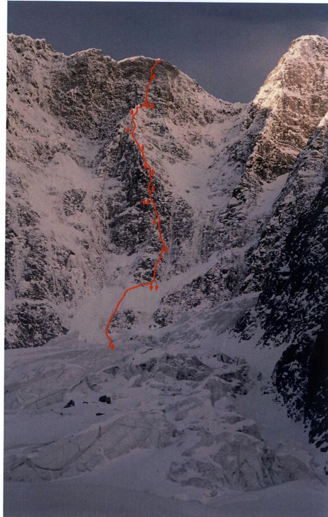
Route line with approximate overnight stay locations
View from Ak-Kem glacier (photo February 15, 2006)
Overnight stay location at the end of the 22nd rope under the summit tower
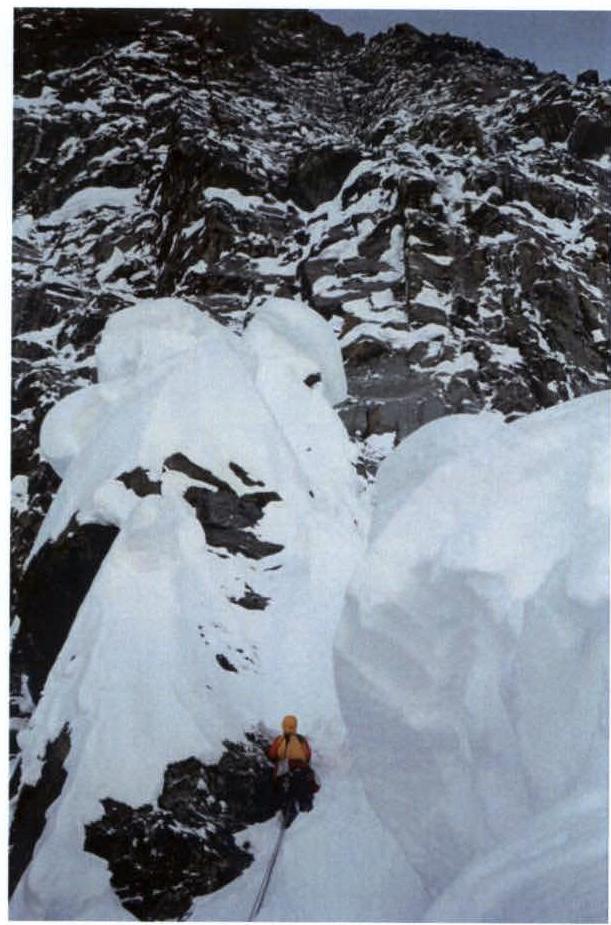
On a snowy ridge. 20th rope, R15 section
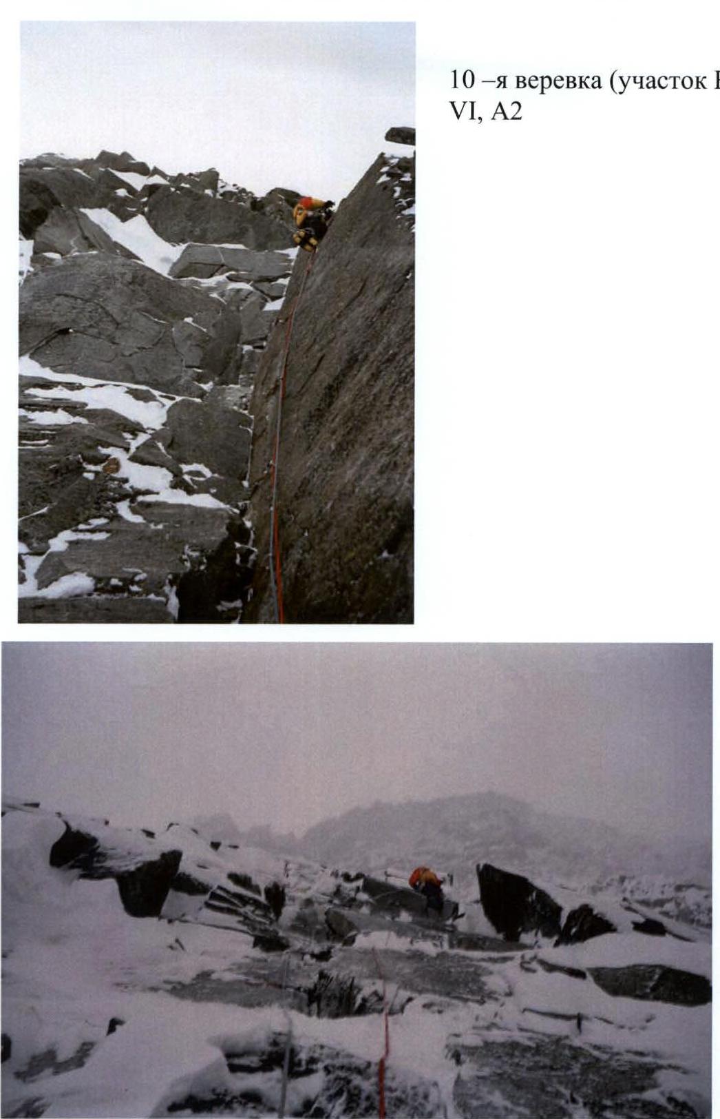
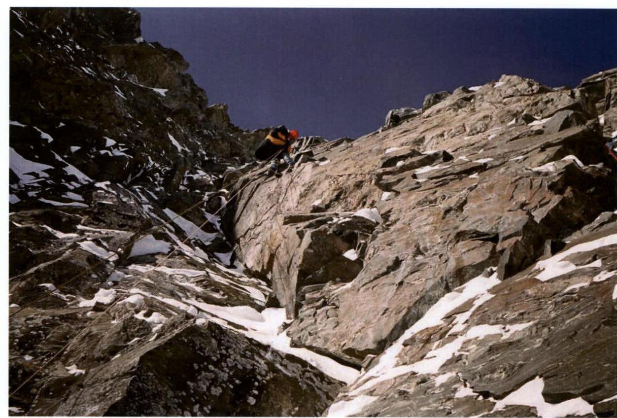
13th rope, R12 section, 4–5 cat. diff.
18th rope, R14 section (last ridge rope, behind the summit tower)
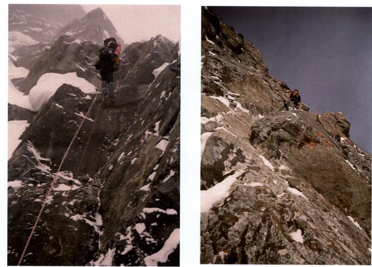
On the ropes on the summit tower. Ropes: 21st (R16), 25th (R20)
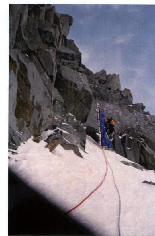
Last rope before exiting to the roof (R24)
Cameraman Oleinik at work. R22 section 


