
I. Belukha-cross by the Central Counterfort of the Northern wall 5B cat. difficulty (first ascent). The ascent was made on August 2-5, 1984 by a group of trainers from the MAL "Altai-84" camp:
- Loktionov V.M. — leader, Master of Sports, instructor;
- Kochetov V.S. — participant, Candidate for Master of Sports, instructor;
- Veiko V.P. — participant, Candidate for Master of Sports, instructor;
- Soloboev V.E. — participant, Candidate for Master of Sports, instructor.
Moscow, 1986
In the 1983 and 1984 seasons, the international mountaineering camp "Altai" operated in the Belukha area. The Northern wall of the Belukha massif (photo 1) drew the most attention and heightened interest from all mountaineers, as it turned out to be unclimbed (at that time).
Two routes were particularly tempting:
- through the center of the Northern wall of East Belukha (via the direttissima);
- Belukha-cross with ascent via the Central counterfort of the Northern wall.
Our choice was unambiguous — Belukha-cross. It was obvious that the greatest difficulty (key point) was passing the overhanging ice step at the upper part of the route. Besides purely technical difficulties, this section also carried significant psychological weight, which apparently explained the long "non-passage" of this logical and beautiful route.
In the 1983 season, we were unable to accomplish our plan, but we conducted thorough observations of the route and made several training ascents, providing brief descriptions of two first ascents. The main task — passing the chosen route — was planned for the summer of 1984.
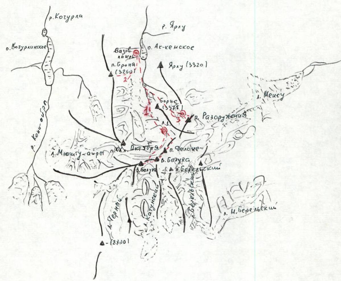
Belukha is located in the very center of the Altai Mountains, in the Katunsky ridge (scheme 1). With an average ridge height of about 3000 m, Belukha rises to 4500 m, which is why its slopes are heavily snow-covered. The summit exceeds the surrounding valleys by more than 2.5 km. From the Akkem lake side (base camp — photo 2), a thousand-meter snow-ice wall is visible, crowned with two snow-white cone-shaped peaks. Numerous fractured ice drops, icy rock outcrops, and avalanche grooves — all this gives the wall a fairly harsh and menacing appearance.
Belukha was first conquered via the simplest path from the south in 1914
 by brothers B.V. and M.V. Tronov. The first ascent of the Belukha-cross route via the Central counterfort of the Northern wall is dedicated to the 70th anniversary of this event — the conquest of Belukha by the Tronov brothers.
Ascent Tactics
The ascent was planned to be made from camp No. 1 — a frame tent on the moraine of the glacier under the "Tomsk" ridge. The journey from the base camp to camp No. 1 (photo 1, photo 2) takes approximately 4 hours. First along a well-defined trail (two crossings, one usually by wading), then across the glacier (exit at the very beginning of the glacier).
Previous observations and training ascents had definitively convinced us that the most challenging part was passing the Northern wall, with the key point being the overhanging ice step. Based on this, and considering the well-studied, rapidly changing weather in the Belukha area, the following ascent plan was made.
Day one — passing the Northern wall and icefall. Overnight stay on the saddle or slightly above the ice step.
Day two — lightweight ascent to the Western peak, descent to the saddle followed by ascent with full gear to the Eastern peak. Overnight stay on the descent ridge.
Day three — return to camp No. 1.
Necessary Equipment
Main rope 2 × 40 m, Repschnur — 20 m, 10 m.
- Ice axes — 3 pcs.
- Ice hammer – 1 pc.
- "Fifi" hook – 2 pcs.
- Crampons — 4 pairs.
- Ice screws — 10 pcs.
- Rock pitons — 7 pcs.
- Carabiners — 28 pcs.
- Climbing grips — 3 pcs.
- 2-step ladders — 2 pcs.
- Tent (silver-coated) — 1 pc.
- "Febus" primus stove — 1 pc.
Considering possible weather surprises, the group was supplied with food for 5 days. Communication with the base camp and other groups of MAL "Altai-84" was ensured by "Lastochka" radios (session frequency — 3 times a day).
Almost the entire route was observable from the base camp by an observation group led by rescue team leader, Master of Sports I. Meshkov.
The tactical plan we chose was largely close to the actual executed plan, taking into account a forced "sit-out" (1 day) on the saddle.
Route Passage
August 1, 1984, 14:00 — the group consisting of Loktionov V., Kochetov V., Veiko V., Soloboev V. left the base camp for the Belukha area to ensure communication, interact with Soviet and foreign mountaineer groups, and make the ascent via the described route.
18:00 — the group reached camp No. 1 on the Akkem glacier moraine.
August 2, 1984, 6:00 — ascent, 7:00 — departure, 8:00 — approached the bergschrund — the start of the route. Further movement was carried out in rope teams:
- V. Loktionov — V. Kochetov;
- V. Soloboev — V. Veiko.
R0–R1. Approach to the rocks, two ropes – 80 m, snow-ice slope of medium steepness – 60°, movement — alternating. Traverse right, up to the start of the crescent-shaped couloir – 80 m, piton belay (4 ice screws).
R1–R2. Crescent-shaped couloir, icy with some rock outcrops, small vertical sections. Length about 6 ropes, average steepness – 75°. Piton belay (21 pitons, mostly ice).
R2–R3. Exit and movement along the rocky-snow ridge. Length 250 m, steepness ~60°, alternating belay (handrails, pitons — 2). At the start of the section, we built a control cairn and had a light breakfast, as the weather was exceptionally great.
R3–R4. Snow ridge, length – 220 m, leading to the key point of the route, relatively simple, average steepness 40°–50°.
R4–R5. Polished rock outcrops, monolithic ice (3 ropes) lead to an ice belt (1.5 ropes) with an overhanging upper part (negative section). The previously existing problem of choosing where to pass the icefall, to the right, left, etc., automatically became irrelevant; there was no desire to look for options. Here, the rope team composition was changed. This section was first passed and processed by the team V. Loktionov — V. Soloboev, without backpacks, using the entire available set of technical means: (25 pitons, ladders, climbing grips, "Fifis", rope pulling — last rope). Average steepness ~70°.
At 18:00, the entire group was above the ice step, and we could breathe a sigh of relief. Above (very close), the edge of the plateau (saddle) was visible; snow fields led to it, and the ice ended.
Considering the snow condition, we decided to set up the tent here so that in the morning, following the tracks made by the second team and now frozen, we could quickly reach the plateau. Suddenly, a ground blizzard hit, and within 10 minutes, it covered everything. The tent site and the tent itself were buried just as quickly.
Night from August 2 to August 3 — strong (very strong) gusts of wind, snow, fog, no visibility.
August 3, 1984, 8:00 — ascent. No change: strong wind, snow, fog, no visibility, breaks are very rare and short. Knowing fairly accurately the location of the upper bergschrund and the direction of movement towards the saddle, we continued the ascent at 10:00.
R5–R6. Snow slopes, steepness ~35°, height difference 150 m. We moved simultaneously, on one rope; at 12:00, we were on the plateau, noticing it not immediately, and for reliability, we moved another 100 meters inwards. We set up the tent and had lunch.
At 16:00, during a rare break in the weather, we attempted to reach the Western peak. Within 10 minutes, everything returned to normal. Visibility was practically zero. We returned. The night was similar to the first, only colder.
August 4, 1984, 6:00 — ascent. Weather and visibility excellent. At 7:00, we set out to ascend the Western peak.
R6–R7. Snow-ice slope with a height difference ~400 m and steepness ~35°–40°, we moved almost simultaneously (2 ice screws).
9:45 — we were on the peak, at 11:00, we descended to the plateau to the bivouac.
11:00–14:00 — well-deserved rest, lunch, departure for East Belukha.
R7–R8. The ascent was made directly head-on, via the snow-ice couloir. Height difference ∼500 m, average steepness ∼50°. Movement was mostly alternating, with piton belay in the upper part. At 18:00, we stopped for the night on the wall of the Delaunay ridge and V. Belukha. Weather conditions were completely analogous to the first day of ascent. By this time, heavy graupel was falling, with wind and minimal visibility.
August 5, 1984 — ascent, light breakfast, departure at 8:00.
At 8:30, we were on the peak, it turned out we had spent the night 100–150 meters from the Main peak.
The planned meeting with MAL "Altai-84" groups did not happen; they were probably hiding from the bad weather.
Clear, cold, beautiful.
At 9:00, we began the descent along the NE ridge (route 4A cat. difficulty) via Delaunay Pass to camp No. 1.
At 15:00, we reached the starting point.
The ascent was completed; the service continued (communication and observation of MAL "Altai-84" mountaineer groups). Everyone was healthy, with excellent morale. Results:
- The route was completed with three overnight stays, in 26 hours of walking time.
- 60 rock and ice pitons were hammered in.
- The total route length (height difference) ∼1500 m, of which ∼900 m was the wall section, with an average steepness of ∼65°.
- The entire route was traversed in crampons.
Conclusions, Recommendations
- The route corresponds to 5B cat. difficulty, is combined, logical, and relatively safe.
- The optimal group size is 4 people.
- The proposed set of equipment is sufficient for a normal passage of the route.
- The route should only be attempted in good weather conditions (day 1) to ensure the safest passage of the wall and setting up a bivouac on the saddle.
- Descent should be carried out in good visibility due to increased cornices, especially in the lower third of the descent ridge (photo 4).
Comments
Sign in to leave a comment