RSFSR CHAMPIONSHIP in ALPINISM ICE-SNOW CLASS
BELUKHA EASTERN 4506 m via North-West wall through icefalls first ascent
SAYANOGORSK 1986
Addresses:
- Krasnoyarsk Krai Saynogorsk City Executive Committee, Committee for Physical Culture and Sports
- Krasnoyarsk Krai Saynogorsk Cheremushki 12-120 Belov A.M.
- Irkutsk Karl Liebknecht 197-2 Afanasiev A.E. Heights were determined by altimeter and copy of topographic base M 1:100000
Map of Ak-kem gorge
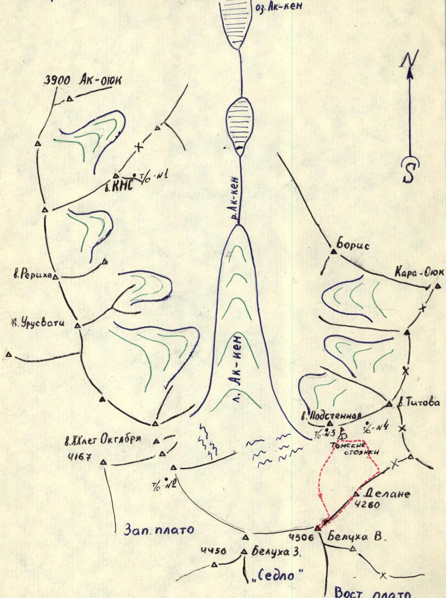
M 1:50000
Brief overview of the area
The Altai mountain system belongs to the Altai-Sayan mountain country, a physical-geographical region of the mountains of Southern Siberia. Here is the highest point of Siberia - Belukha mountain (4506 m). The main peaks of the region have a height of more than 4000 m. The average height of the peaks on which climbing routes are laid is 3900 m.
The Belukha massif has 162 glaciers with a total area of 146 sq. km. The snow line lies at 2750-2850 m, and therefore the mountains are covered with loose deep snow even in the summer period. Locals call the peaks of non-melting ice and snow "beloks" (Cold Belok, Royal Belok, Belok Bystrukhin Spire, etc.). Climbing and glaciological expeditions arbitrarily named many peaks without regard to local traditions, and currently, in the central part of the Katunsky ridge, the name "belok" is rarely found.
A fairly large glaciation in these relatively low mountains is explained by their northern location; the Ak-kem gorge is located at 50° north latitude. In summer, there are very short nights and long twilight, which is convenient for early departures on routes. In addition, the Altai mountains are a continuous obstacle to moisture-bearing western winds of temperate latitudes. Solid precipitation in the form of snow and hail falls in the glacial-nival zone mainly in the summer period, which creates known inconveniences and dangers when working on routes.
In the lower zones, the following features are observed:
- Frequent rains in the tundra and taiga zones;
- Rains contribute to the marshing of the area;
- Marshland makes it difficult to approach the glaciers.
The Altai mountains have undergone several periods of mountain formation, starting from the Hercynian and ending with the Alpine folding. The rocks are predominantly metamorphic and intrusive. The most ancient of them is more than 400 million years old (Ordovician period of the Paleozoic).
In geomorphological terms, the mountains are heavily destroyed, so:
- on rock routes, the rock hazard is increased in the internal forms of relief;
- on ice routes, especially those with a northern exposure, rocky outcrops are rigidly gripped by an ice carapace.
Due to low winter temperatures:
- ice is heavily frozen and becomes very hard;
- even in summer, under the influence of rare sunlight, it does not have time to loosen.
Preparation for the ascent
In sports terms, the ascent area is quite poorly developed. The first ascent to Belukha and traditional routes go from the south from the Katunsky glacier and the Black glacier.
Expeditions of the 50s were conducted by E. Kazakova from the Men-su glacier. The first expedition from the Ak-kem gorge took place in 1933 under the leadership of V. Abalakov. Subsequently, Tomsk climbers made ascents from this side at events organized by G. Andreev in 1963 and 1972. Since 1982, the "Altai" youth team has been based at Ak-kem almost every year.
No climbing events have ever been held on the peaks of the Belukha massif from the side of the Big and Small Berelsky glaciers and the Miushtu-airy glacier.
To date, only a few routes of varying difficulty have been classified from the Ak-kem cirque in the Belukha massif, including three of category 5B. However, the area has many more logical, more complex unclassified routes.
The team members have been studying Altai for a long time using literature and direct visits. Some participants had experience climbing Belukha. The objects of ascent and possible route options were not chosen randomly. Observations of the state of icefalls and snow slopes in the area of possible routes were carried out by the team coach A.E. Afanasiev over several winter and summer months in previous years. With the help of optical instruments, it was possible to establish the regime of icefalls, dangerous areas, and safe sections for passage, as well as to assess the state of flow ice and snow rime on the rocks of the lower, steeper half.
In connection with the assessed ice-snow and rock situation on the route, preparations were made for the ascent, as well as the selection of necessary equipment. Based on observations of the state of the route, in addition to the usual equipment, the following were selected:
- Ice axes with flaps;
- "Cascade" crampons with one front tooth;
- Hammers of special beak design;
- Rock pitons for ice-filled cracks.
The team underwent a cycle of training sessions on ice according to the "school" program, and training ascents were conducted to improve team cohesion: 3A, 4A, 5A; ascent of category 5A on a pure ice route to West Belukha via the Akkem wall through the Western plateau.
During the gathering process, the team underwent medical examination and passed physical fitness tests, based on which the final team composition was determined.
Tactical actions of the team
The team planned to start the route at night in order to pass the lower part of the route safely before the sun illuminated the upper slopes. Work from the bergschrund began at 3:00. The first hour was worked under the light of headlamps. The first steep ice climb was made on the left side. At the fifth hour, it started to get light, and navigation on the route became easier.
On rocky sections, passage was carried out along gutters of flow ice. In some places, snow rime on rocks and overhanging cliffs made passage difficult. For belaying, it was necessary to drive rock pitons. In the upper part of the seventh section, a detour around the rock "bird" goes along the right vertical ice flow.
After the "bird", there is an exit to an ice slope, then through a series of rock belts to the first icefall. Here the movement is alternate with the use of belaying via rock and ice pitons and chocks.
The first icefall is a vertical, overhanging ice cliff in its upper part, two rope lengths long. The ice turned out to be somewhat more difficult than expected. It is so heavily frozen that it shatters into large lenses when struck with an ice axe; ice axes slip on its surface without catching. Passage of the icefall was possible with the use of artificial footholds on ice hammers. For belaying, quick-twisting ice screws with a welded handle were used.
The cliff of the second icefall is made of firn. Passage, especially of the upper overhanging eave, was possible only with the use of ice axes with flaps. The snow slope on the cushions below the ridge becomes avalanche-prone in the afternoon. The most acceptable path is direct. The team worked on these sections until 13:00.
The team completed the declared route in accordance with the tactical plan. No insurmountable problems arose. The time schedule was followed to the minute.
Ascent schedule
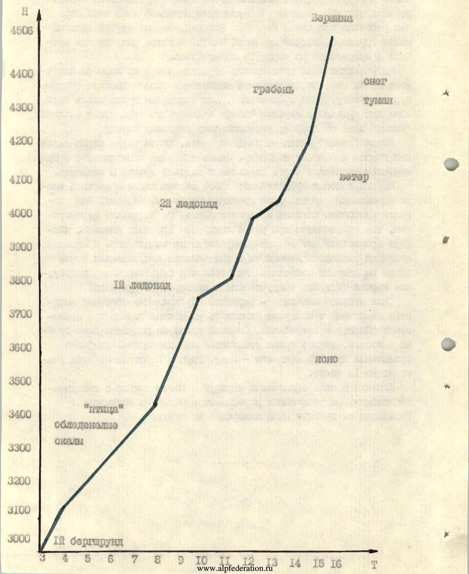
Route diagram in UNAA symbols M 1:2000
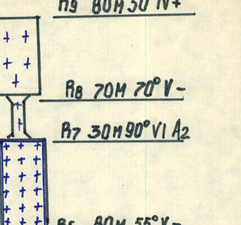
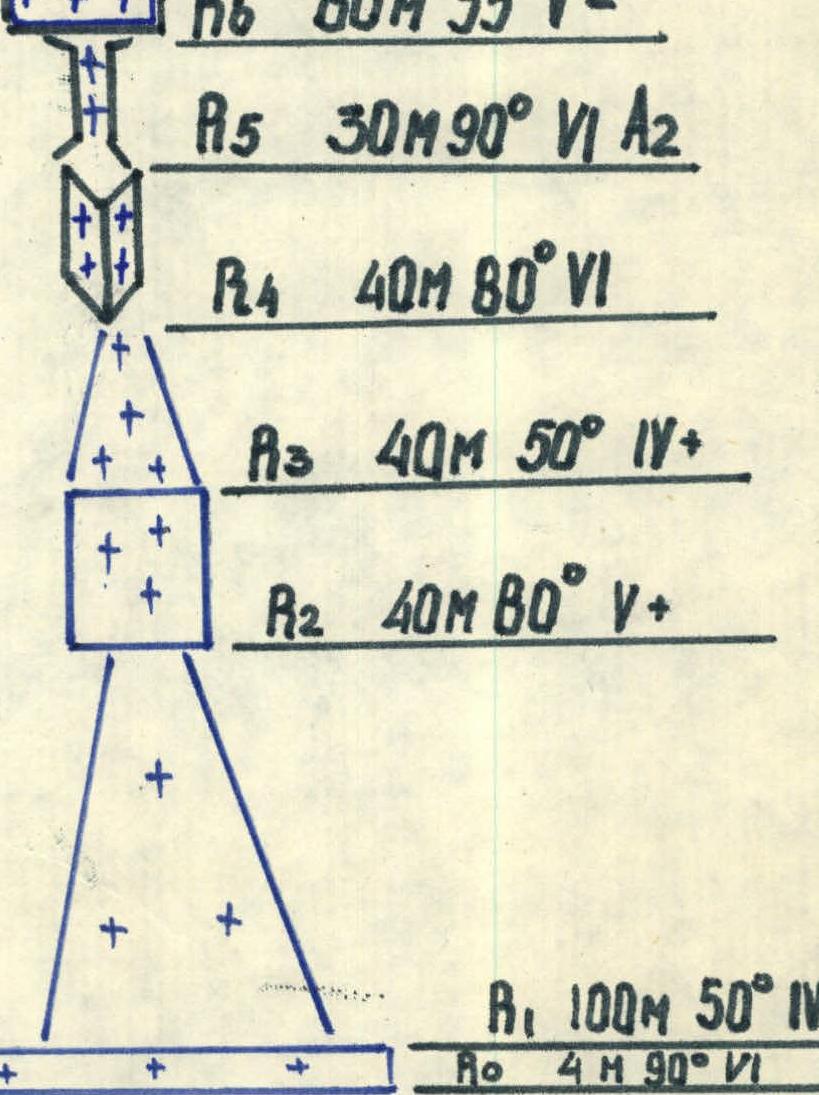
R9: 80 m 50° 4 R8: 70 m 70° 5 R7: 30 m 90° 6 R6: 80 m 55° 5 R5: 30 m 90° 6 R4: 40 m 80° 6 R3: 40 m 50° 4 R2: 40 m 80° 5 R1: 100 m 50° 4 R0: 4 m 90° 6
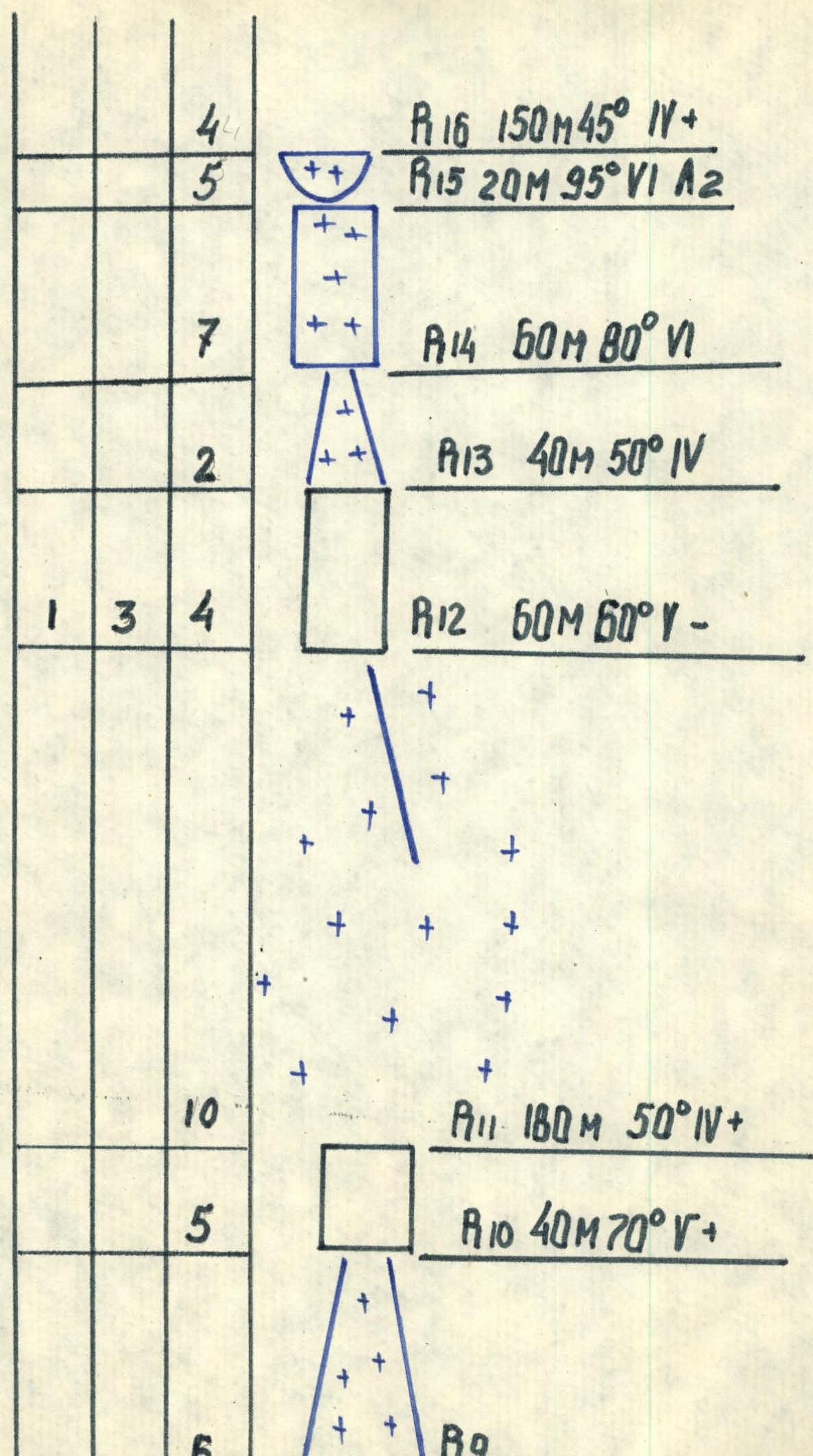
R16: 150 m 45° 4 R15: 20 m 95° 6 R14: 60 m 80° 6 R13: 40 m 50° 4 R12: 60 m 60° 5 R11: 180 m 50° 4 R10: 40 m 70° 4
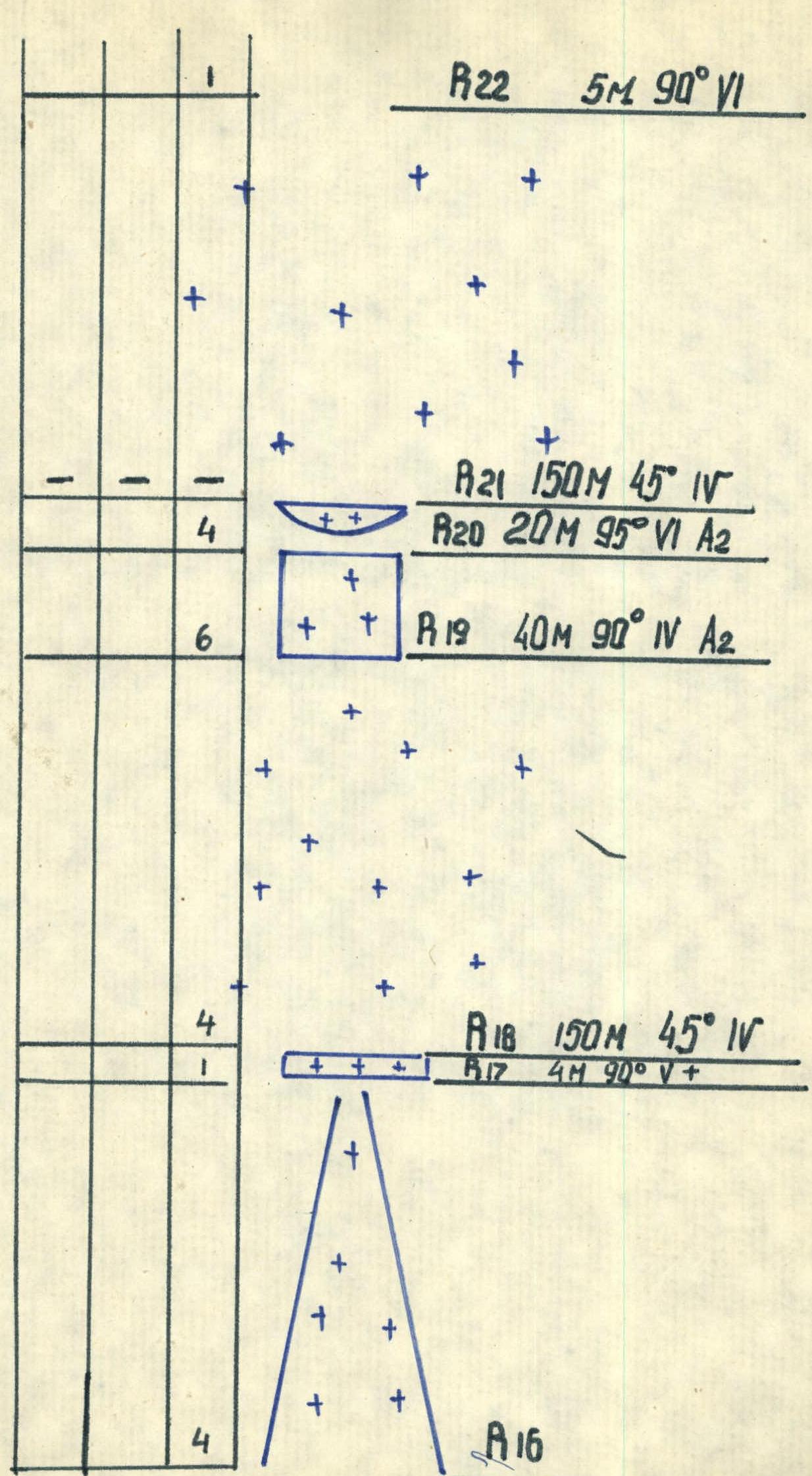
R22: 5 m 90° 6 R21: 150 m 45° 4 R20: 20 m 95° 6 R19: 40 m 90° 4 R18: 150 m 45° 4 R17: 4 m 90° 5
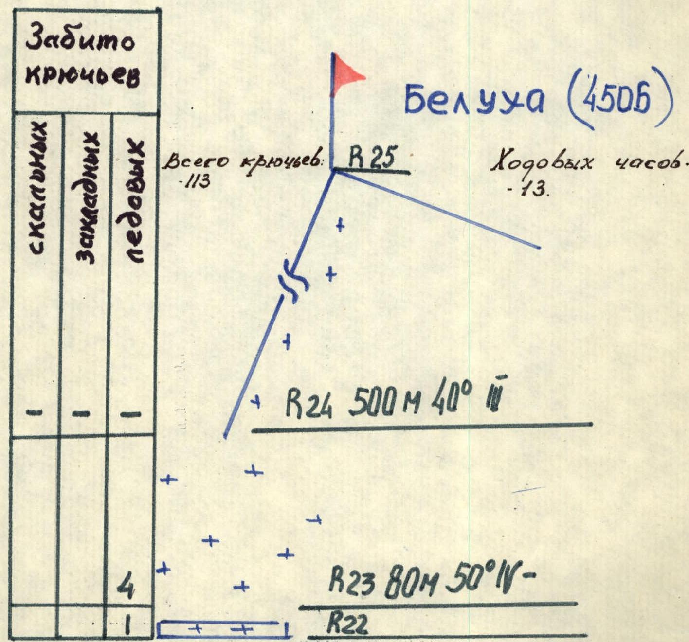
R25: (Belukha summit 4506 m) R24: 500 m 40° 3 R23: 80 m 50° 5
 www.alpfederation.ru↗
 www.alpfederation.ru↗
 www.alpfederation.ru↗
Route description by sections
The approach to the start of the route from the "Tomsk campsites" takes 1 hour. Crossing the glacier across the snow field of the upper cirque of the Akkem glacier, almost without gaining or losing height under the walls of Delaunay peak. The last 100 m to the bergschrund have very deep, loose snow.
Sec. 0-1 First bergschrund. 4 m, slight overhang, passed using ice axes and ice axe, rope ladder. Cat. 6. Sec. 1-2 Ice gutter with steep firn walls 100 m, 50° under a steep ice belt. Cat. 4. Sec. 2-3 Ice wall stretches in a belt across the firn slope from rocks to rocks. It is more convenient to pass on the left, where the wall is more gentle and a bit shorter, 40 m, 80°. Cat. 5. Sec. 3-4 Firn slope covered with snow 40 m, 50° under the first rocks. Cat. 4. Sec. 4-5 Internal corner with flow ice, snow-covered 40 m, 80° turning into a chimney. Belaying via rock pitons. Cat. 6. Sec. 5-6 Vertical chimney 30 m. Passage along the ice flow using artificial aids via ice axes and ice hammer. At the exit, there are snow rime with ice underlay. Cat. 6. Sec. 6-7 Icy slab with rock outcrops. Thin ice. 80 m, 55°. Belaying via ice screws. Cat. 5. Sec. 7-8 Vertical ice flow in a rock gutter to the right of the "bird", 30 m. Artificial aids on ice axes. Cat. 5. Sec. 8-9 Blocky, ice-filled rocks with an overall steepness of 70 m, 70°. Cat. 5. Sec. 9-10 Snow-ice slope 2 rope lengths, 50°. Cat. 4. Sec. 10-11 Rock belt one rope length with an overall steepness of 70°. In the middle part of the section, there is a vertical five-meter ice gutter. Cat. 4. Sec. 11-12 Pure ice slope, hard ice. In the upper part of the section, there is a transition to the right onto a snow ridge. Overall characteristics of the section: 180 m, 50°. Cat. 5. Sec. 12-13 Upper rock belt 60 m, 60°. Climbing in crampons, good cracks for chocks. Cat. 4. Sec. 13-14 Snow-ice slope 40 m, 50° to the first icefall. Cat. 4. Sec. 14-15 Cliff of the first icefall. Very hard, frozen ice, surface smooth as glass. 60 m, 80°. Ice screws are hard to place. Cat. 6. Sec. 15-16 Ice wall turns into an overhang 95°, 20 m. Passage with artificial aids via ice hammers, exit to a snow cushion. Cat. 6. Sec. 16-17 On snow 150 m, 45°, belaying in case of an avalanche via ice screws. It is necessary to dig holes with an ice axe to the ice, sometimes it is possible to burrow into ice islands. Cat. 4. Sec. 17-18 Second bergschrund 4 m, 90°, hard ice. Exit of the first participant with a leg up. Cat. 5. Sec. 18-19 Upper part of the first snow cushion - 150 m, 45°, approach to the firn cliff of the second icefall. Cat. 4. Sec. 19-20 Lower part of the second icefall. Dense firn, work on ice axes, belaying via blocked ice screws buried in layers and lenses of ice. 40 m, 90°. Cat. 6. Sec. 20-21 Upper part of the second icefall. Overhanging eave of soft firn, work on ice axes with flaps, at the exit, securing the rope via blocked ice axe and ice axe. 20 m, 95°. Cat. 6. Sec. 21-22 Second snow cushion 150 m, 45°. Cat. 4. Sec. 22-23 Third bergschrund. Deep crevasse perpendicular to the slope, upper wall slightly overhangs. Dense snow. Exit with a leg up and on ice axes stuck with their tips. Cat. 6. Sec. 23-24 Firn slope with ice crusts 80 m, 50°, exit to the Delaunay-Belukha ridge 4200 m. Cat. 3. Sec. 24-25 Summit ridge. Caution: snow cornices. 500 m, 40°, exit to the summit. Cat. 3.
Total pitons: 113. Climbing hours: 13.
Team captain A. Belov Team coach A. Afanasiev

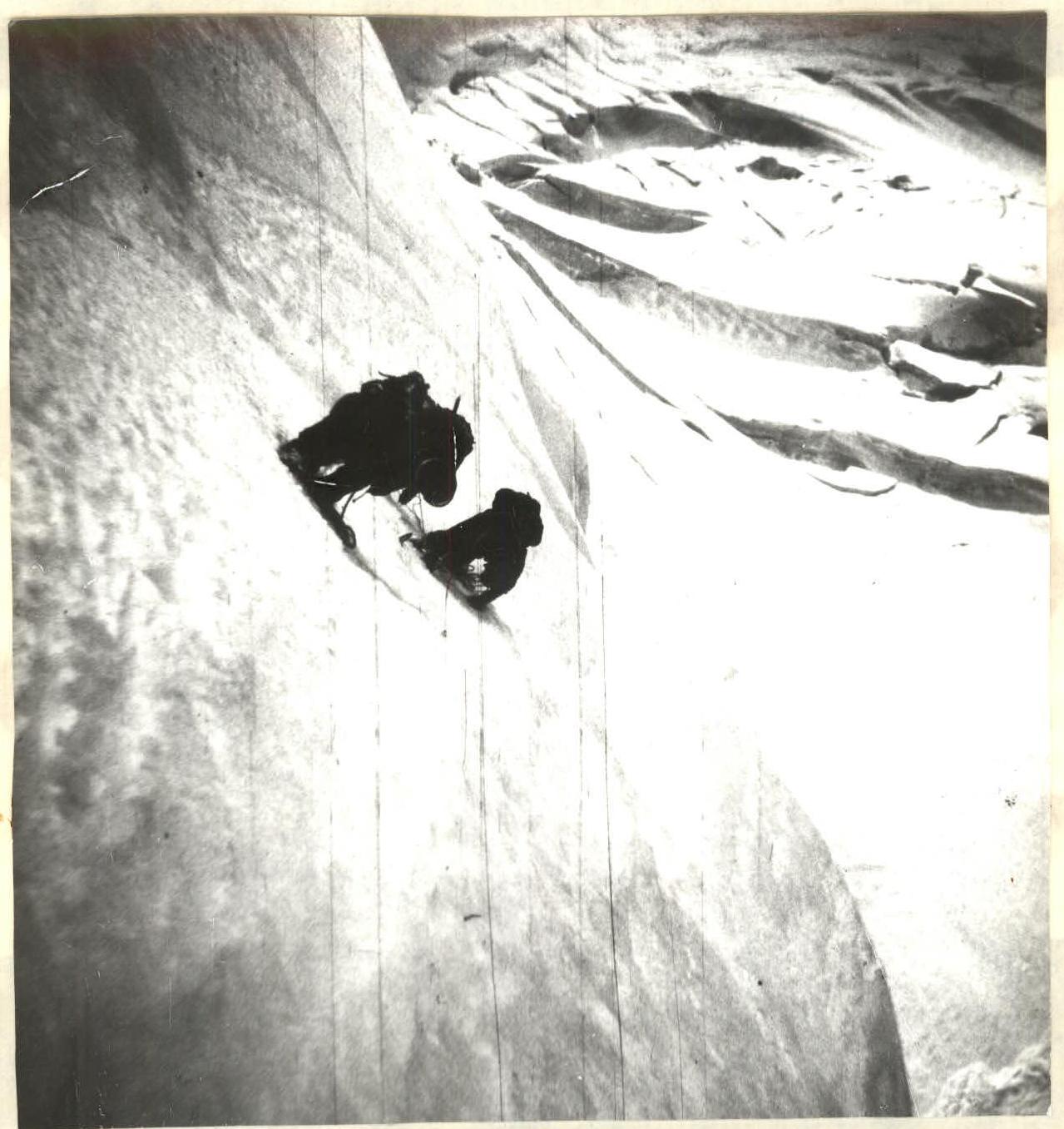
Photo 1. Section 7-8. July 14, 1986. 8:00. Lens T-43.
Photo 2. Section 13-14. July 14, 1986. 10:00. Lens T-34
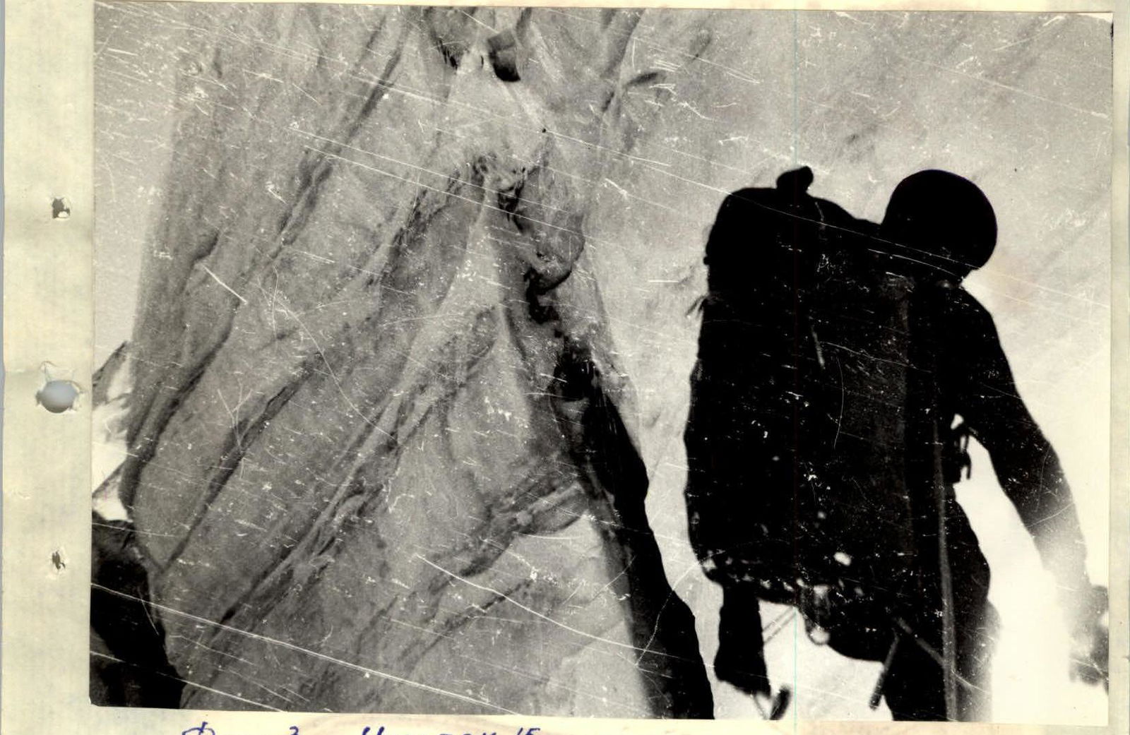
Photo 3. Section 15. July 14, 1986. 11:00. Lens T-43.