ASCENT CERTIFICATE
- Ascent class — technical.
- Ascent area, ridge: Altai, Katunskie Belki.
- Peak, its height, ascent route, route type: Belukha V. 4506 m, via the North face through the saddle, ice.
- Proposed category of difficulty — 5A cat. diff.
- Route characteristics: height difference — 1500 m, length of 5–6 cat. diff. sections — 214 m, average steepness — 50°.
- Pitons driven: rock 6, ice 55.
- Number of climbing hours: 12 hours.
- Overnights — none.
- Full name of the leader, participants, their qualification:
- Yakovenko A.N. — CMS, leader
- Neumann Yu.E. — 1st sports rank, participant
- Grebenyuk Yu.N. — II sports rank, participant
- Vakhromeev A.G. — II sports rank, participant.
- Team coach: Afanasyev A.E. — Master of Sports of the USSR.
- Date of departure and return: July 18, 1986.
- Organization: classification competitions SCA-19.
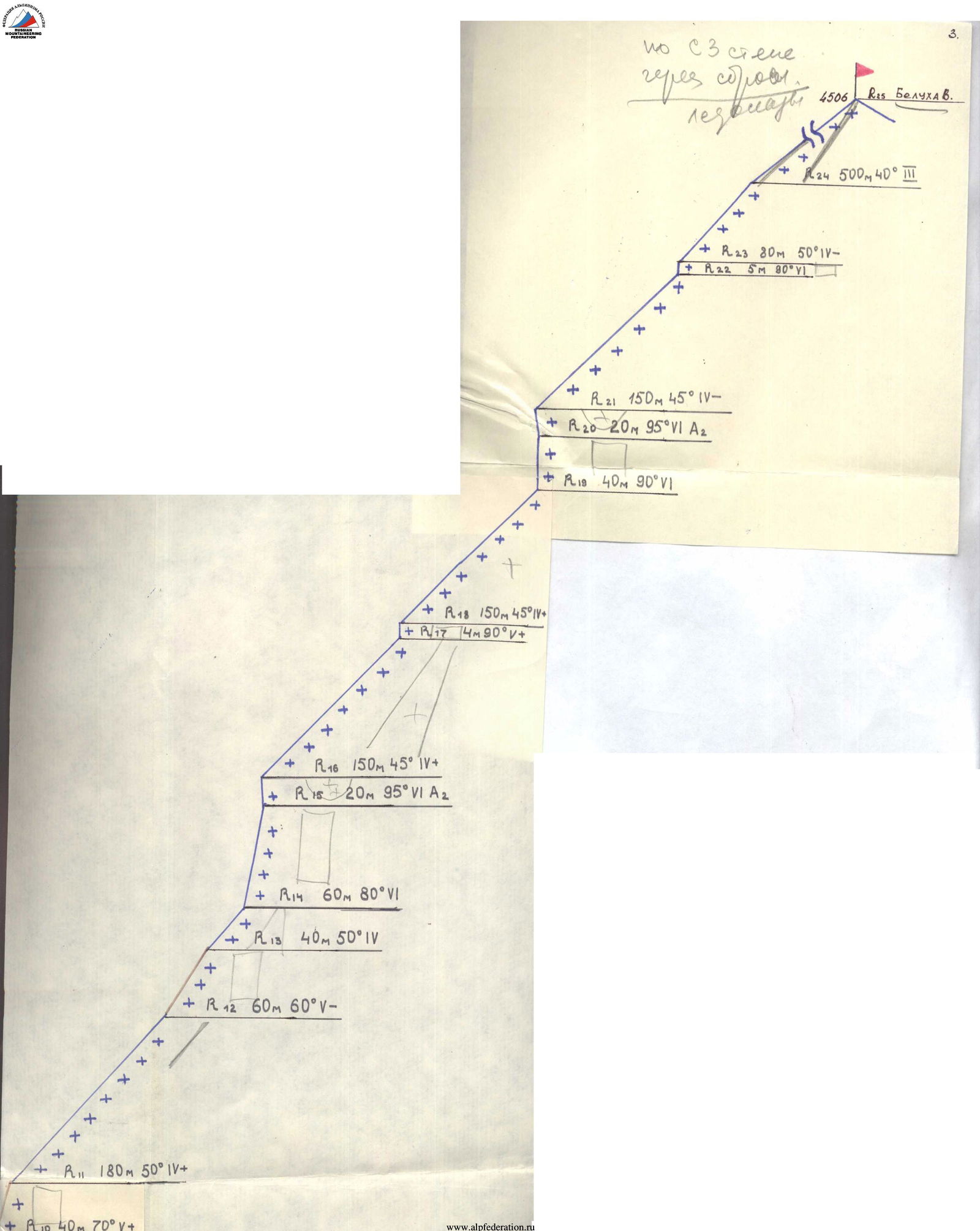
20 m 50° IV
150 m 45° IV
20 m 95° VI A2
40 m 80° VI
150 m 45° IV
150 m 95° VI A2
40 m 80° VI
180 m 50° IV
180 m 50° IV
180 m 50° IV
150 m 45° IV
150 m 95° VI A2
150 m 45° IV
150 m 95° VI A2
180 m 50° IV
180 m 50° IV
180 m 50° IV
180 m 50° IV
150 m 40° IV
150 m 95° VI A2
150 m 40° IV
150 m 95° VI A2
150 m 40° IV
150 m 95° VI A2
150 m 40° IV
150 m 95° VI A2
150 m 40° IV
150 m 40° IV
150 m 95° VI A2
150 m 40° IV
150 m 40° IV
150 m 40° IV
150 m 40° IV
150 m 40° IV
150 m 40° IV
150 m 40° IV
150 m 40° IV
150 m 40° IV
150 m 40° IV
150 m 40° IV
150 m 40° IV
150 m 40° IV
150 m 40° IV
150 m 40° IV
150 m 40° IV
150 m 40° IV
150 m 40° IV
150 m 40° IV
150 m 40° IV
150 m 40° IV
150 m 40° IV
150 m 40° IV
150 m 40° IV
150 m 40° IV
150 m 40° IV
150 m 40° IV
MAP SCHEME OF THE Ak-kem VALLEY AREA
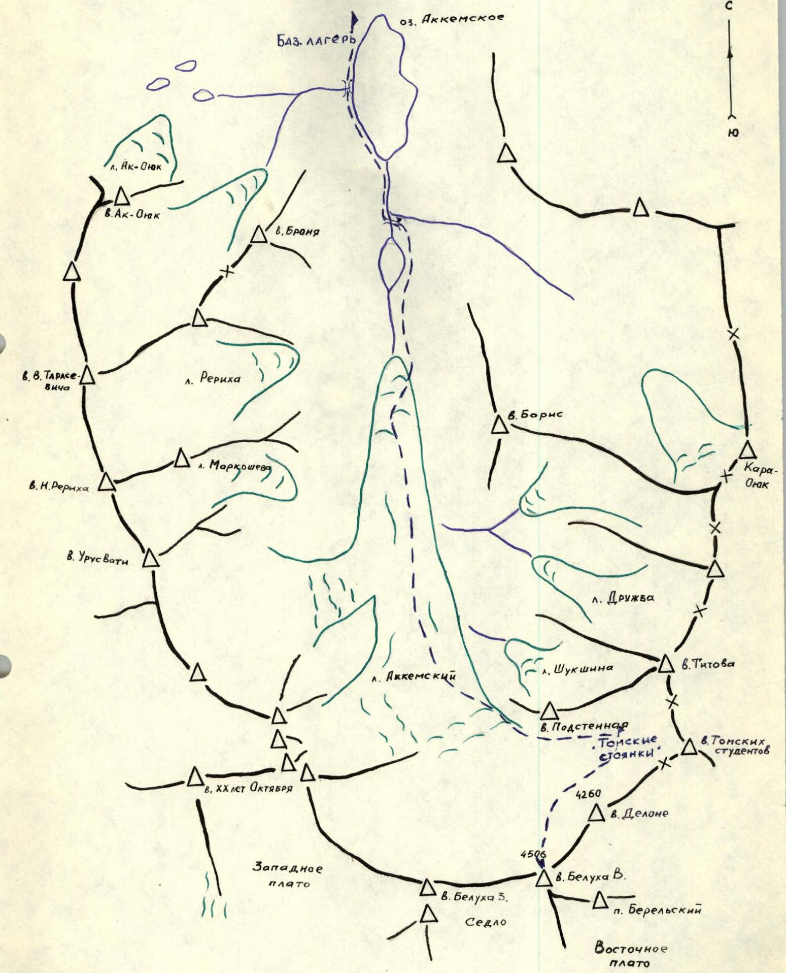
Description of the approach to the route
The ascent to Belukha V. via the North face is more conveniently done from the "Tomskie nochyovki" campsite. The approach from the base camp on Ak-kem lake to "Tomskie nochyovki" takes 6 hours. Along the left side of the lake and river, with a crossing to the other bank between the Upper and Lower lakes. The Ak-kem glacier is accessed via a trail marked by cairns. It's easier to ascend the glacier via the central part. The passage through the icefall to the upper cirque is along the right bank among the crevasses. "Tomskie nochyovki" is located on the lateral moraine under the slopes of Podstennaya peak. Here is a KSS tent with a stove. From "Tomskie nochyovki", crossing the upper cirque with a slight descent, the approach is to the foot of the central counterfort of Belukha V. The route goes to the left of the central counterfort along the ice slope.
Brief explanations for the table
- R0–R1 — ice bergschrund
- R1–R2 — ice slope, hard ice
- R2–R3 — steep snow-ice ridge with cornices to the left
- R3–R4 — frozen rocks, passage through gullies, protection via rock and ice pitons
- R4–R5 — series of seracs of the hanging glacier
- R5–R6 — ice drop, very difficult climbing
- R6–R7 — snow-ice pillows, alternating with bergschrunds
- R7–R8 — overhanging snow cornice, passed in a convenient place by cutting through
- R8–R9 — series of ice couloirs and rock outcrops on the eastern slope
- R9 — summit ridge
Descent via the 4A cat. diff. route.
Route diagram in symbols


