
Report
on the first ascent to the summit of Shaitankhana (Kotin Peak) via the right part of the western wall, category 5B, by the team Vasily Terekhin – Evgeny Korulin (Krasnoyarsk Krai)
from July 22 to July 23, 2019
2020
Climbing Passport
| 1. General Information | ||
|---|---|---|
| 1.1 | Full name, sports rank of the leader | Vasily Andreyevich Terekhin, Master of Sports |
| 1.2 | Full name, sports rank of the participants | Evgeny Sergeyevich Korulin, Master of Sports |
| 1.3 | Full name of the coach | Nikolai Nikolayevich Zakharov, Honored Coach Valery Viktorovich Balezin |
| 1.4 | Organization | Ministry of Sports of Krasnoyarsk Krai |
| 2. Characteristics of the Climbing Object | ||
| 2.1 | Region | Gissar-Alay |
| 2.2 | Valley | Karavshin |
| 2.3 | Section number according to the 2013 classification table | 5.4.3 |
| 2.4 | Name and height of the summit | Shaitankhana (Kotin), 4521 m |
| 3. Characteristics of the Route | ||
| 3.1 | Route name | Via the right part of the western wall |
| 3.2 | Complexity category | 5B |
| 3.3 | Degree of route exploration | First ascent |
| 3.4 | Relief characteristics of the route | Rock climbing |
| 3.5 | Height difference of the route | 1400 m |
| 3.6 | Route length | 1800 m |
| 3.7 | Technical elements of the route | II, III category rock - 500 m. IV category rock - 280 m. V category rock - 505 m. VI category rock - 515 m (including 7a - 40 m). |
| 3.8 | Average steepness of the route, (°) | 55° |
| 3.9 | Average steepness of the main part of the route, (°) | 60° |
| 3.10 | Descent from the summit | Via the 3rd wall |
| 3.11 | Additional route characteristics | |
| 4. Characteristics of the Team's Actions | ||
| 4.1 | Movement time | 13 hours |
| 4.2 | Overnight stays | On descent at section R13 |
| 4.3 | Route preparation time | - |
| 4.4 | Start of the route | 7:00, July 22, 2019 |
| 4.5 | Reaching the summit | 20:00, July 22, 2019 |
| 4.6 | Return to the base camp | 13:00, July 23, 2019 |
| 6. Person responsible for the report | ||
| 6.1 | Full name, e-mail | Vasily Terekhin, iceterkin@mail.ru |
Climbing Description
1.1. Characteristics of the Climbing Object
The Karavshin region is located in the Batken Province of Kyrgyzstan, and is considered a mecca for technical alpinism, attracting climbers from both Russia and abroad. Most routes in Karavshin are category 5B and 6B in complexity, and the area is relatively compact in terms of approach and very monolithic.
Shaitankhana Peak, also known as Kotin Peak (4521 m), is located near the standard base camp site in the Kara-Su valley. The first ascents to the summit date back to 1988, at the beginning of the Karavshin area's exploration. The ridge of Shaitankhana - Kyrkchilta - Odessa is a classic composition for photographs taken by most tourists and climbers visiting the area. There are 6 classified routes to Shaitankhana in the FAR database:
- South ridge (Igolkin, 4A, 1990);
- North ridge (Vasilkov, 4B, 1988);
- Northeast wall (Maksimov, 5B, 1988);
- Right part of the eastern wall (Portyanko, 5B, 1988);
- Central counterfort of the northwest wall, 6A (Temerev, 2018);
- Internal angle of the western wall and center of the upper bastion, 6A (Temerev, 2019).
Two of the three wall routes start from the neighboring Ak-Su valley. The western exposure of Shaitankhana is relatively unexplored.
The relief of the western exposure is diverse and relatively safe for climbing and belaying. The route taken by the team proved to be logical, safe, and interesting. The descent from the summit can be done via the north ridge - Vasilkov's route, 4B (not recommended) or via a descent route established by foreign climbers along the western wall. Detailed information about the descent is provided later in the report.
1.2. General Photo of the Route
The photo was taken from the summit of Yellow Wall 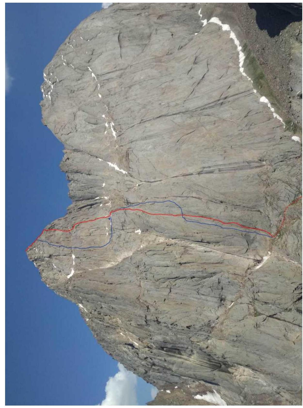
Red - ascent line, blue - descent path
1.2. General Photo of the Route
The photo was taken from the summit of Yellow Wall 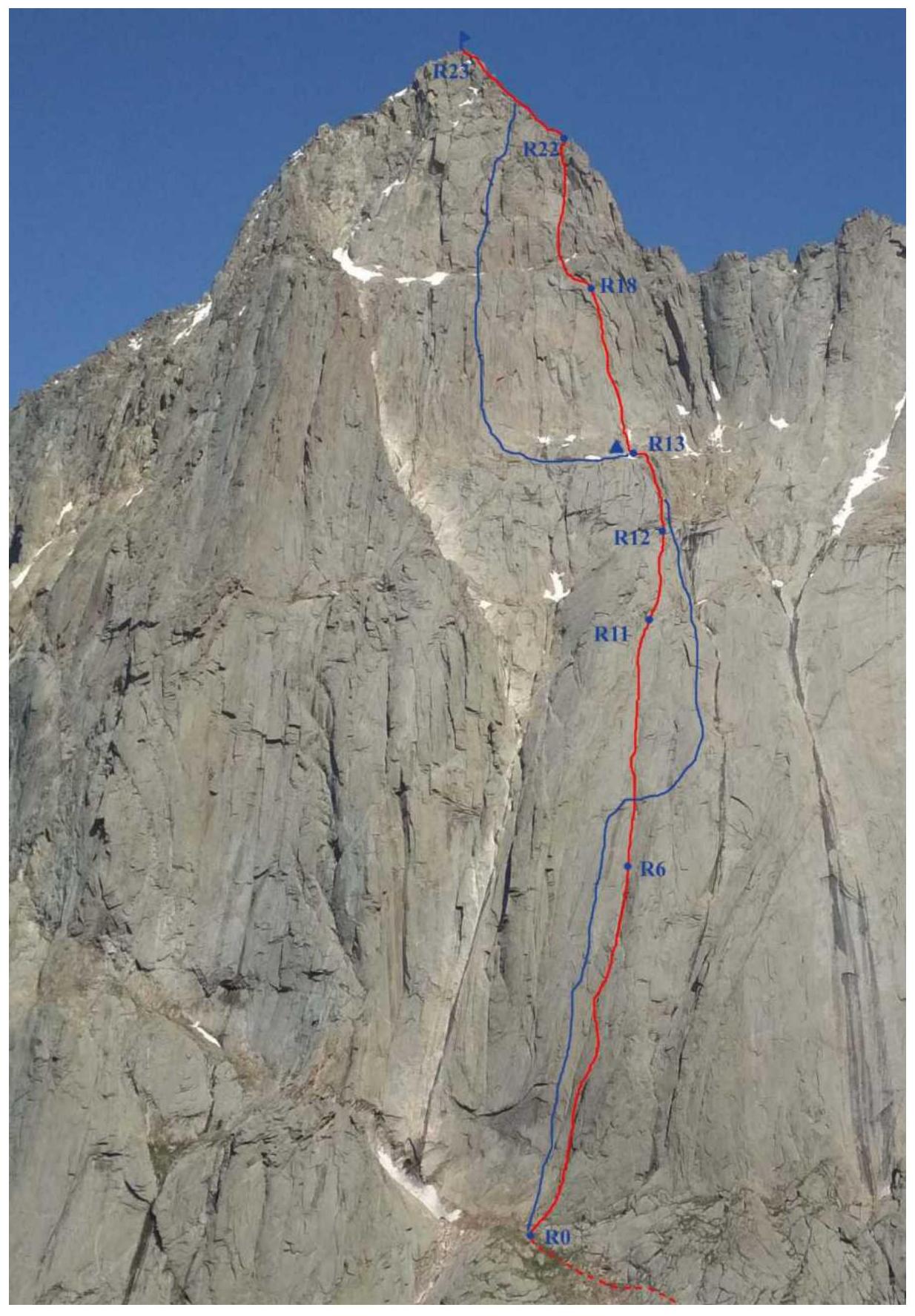
Red - ascent line, blue - descent path
1.2. Second and Third Bastions
The photo was taken from the "central" ledge (R13) 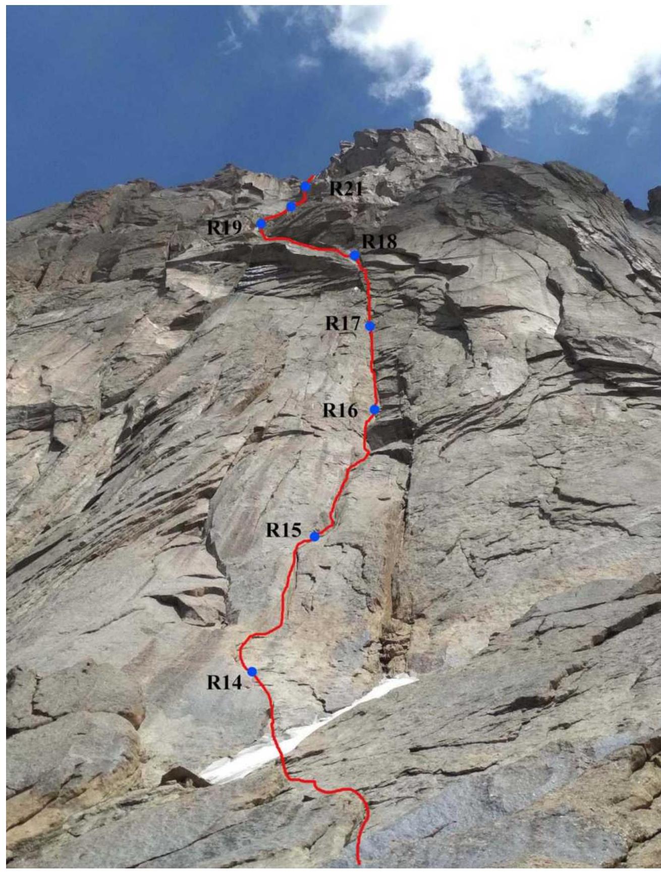
1.3.1. Photo of the Route Profile
Taken from the north from the Kara-Su valley. 
1.4. Route Profile
3110 m
55°
60°
4521 m
R23
R22
R19
3960 m
R13
50 m
R12
R11
R8
R6
R0 
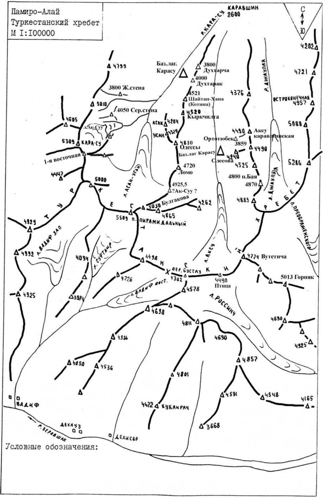
1.5. Map-Scheme of the Area
Pamiro-Alay Turkestan Range Scale 1:100000
KARAVSHIN
2600
Base camp
Kara-Su
3800
R.KARA-SU
Dukhtarcha
4000
Dukhtarrak
4376 A
4521
Shaitankhana
(Kotin)
R.DZHAUAYA
4202
4721
4050 Ser.stena
4520
OSTROKONECHNAYA
4957
Kyrkchilga
5088
ASAN 4204
44329
Ortotubek
Ak-Su
Karavshskaya
4810
4490
Base camp Kara-Su
3859
4720
Slesova
5246
LOMO
4525
4925.5
4800 p.Baya
4870
Ak-Suu?
4262
5030 Bulgakova
4889
4865
5509 P.Piramidal'nyi
DZhAUAYA
4726
4498
L.AK-SU
DER.BUSTAZ
4382
44578
4274 Vutetic
Dadif West
5013 Gornak
4490
Ptitsa
L.ROSSINCh
4690
4811
4690
4925
4857
4801
4590
4548
4422 KUKLI RACH
4165
3668
DEKhAUZ
DEKhISAR
R.ZERAVSHAN
Conventional signs:
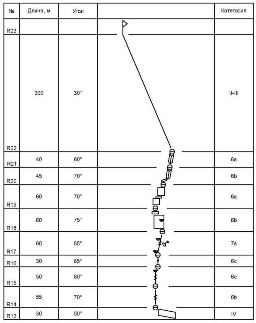
Route Scheme in UIAA Symbols
| № | Length, m | Angle | Category |
|---|---|---|---|
| R13 | 200 | 45° | III |
| 250 | 45° | IV | |
| R11 | |||
| R10 | 60 | 50° | V |
| R9 | 60 | 50° | V |
| R8 | 50 | 50° | V |
| R7 | 60 | 55° | V |
| R6 | 55 | 55° | V |
| R5 | 60 | 70° | 5c |
| R4 | 55 | 70° | 6a |
| R3 | 50 | 70° | 6b |
| R2 | 55 | 70° | 6a |
| R1 | 55 | 70° | 5c |
| R0 | 55 | 70° | 6a |
Route Scheme in UIAA Symbols
| № | Length, m | Angle | Category |
|---|---|---|---|
| R23 | 300 | 30° | II-III |
| R22 | 40 | 60° | 6a |
| R21 | 45 | 70° | 6b |
| R20 | 60 | 70° | 6a |
| R19 | 60 | 75° | 6b |
| R18 | 60 | 85° | 7a |
| R17 | 30 | 85° | 6c |
| R16 | 50 | 80° | 6c |
| R15 | 55 | 70° | 6b |
| R14 | 30 | 50° | IV |
| R13 | |||
 |
Tactical Actions of the Team
When choosing the line for the first ascent, we wanted to create a route that could be climbed mostly using free climbing techniques. Additionally, we aimed to climb it in a fast and light style, where both participants climb freely (the second with a backpack). However, we understood that climbing a route over 1.5 km long with a height difference of over 1 km in one daylight period is practically impossible, especially considering that a strong foreign team had previously attempted a similar route and had to spend the night on descent under the summit.
We took advice from them on the ascent and descent route since they had just equipped the lower bastion with rappel anchors.
Based on the above, we decided to bring a lightweight tent weighing 1 kg, a thin sleeping mat, an emergency blanket, a jet boiler, some food, personal items, a radio, and a first-aid kit (we sacrificed the sleeping bag to save weight and volume). However, despite our efforts to minimize weight, the second climber's backpack still weighed around 13 kg, which caused significant difficulties during climbing until we left the bivouac on the "central" ledge.
The entire route can be divided into 4 sections:
- First bastion - R0-R13 (moderate climbing on gentle slabs) {between the first and second bastions is the "central" ledge};
- Second bastion - R13-R19 (difficult climbing, key section of the route);
- Third bastion - R20-R22 (moderate climbing, blocky rocks);
- Ridge - R22-R23 (easy climbing, simultaneous movement).
We left the Kara-Su base camp at 4:30, and by 6:30, we reached the start of the route. It was decided that Korulin would lead the first bastion (up to the "central" ledge), and Terekhin would lead the second and third bastions.
We started working on the route at 7:00 and reached the "central" ledge by 14:00 (end of the first bastion).
The first bastion involves moderate climbing mostly on positive angles and slabs. The length of this section is over 1000 m. The difficulty varies from V to 6B and decreases to IV in the final sections. The main challenges of this section are its significant length and the weight of the second climber's backpack.
Initially, we planned to camp somewhere under the summit, but after being exhausted by the weight of the backpacks and motivated by our progress, we decided to leave our bivouac and unnecessary items on the "central" ledge, taking only membrane jackets and headlamps (a decision we later almost regretted).
It's worth noting that due to the steepness of the second and third bastions and the scale of the mountain, the remaining part of the route didn't seem very long, although the 500 m height difference indicated otherwise.
The second bastion is the most challenging part of the route. The rock face here reaches up to 90° (the crux is 7a), with very demanding and interesting climbing, featuring cornices, chimneys, and narrow cracks from 3 mm to fist-sized. The terrain is monolithic, with some sections having a running stream.
We reached the ledge at the start of the third bastion at 17:30. The terrain then becomes simpler, with blocky rocks and climbing categorized as V-VI, interspersed with ledges. Our speed began to decrease due to fatigue.
We reached the ridge at 19:30, and then climbed 300 m along the ridge to the summit, overcoming small walls and short climbing sections. We reached the summit at 19:55.
The weather was good during the ascent, but the sky became increasingly cloudy after noon, making us wonder if leaving our bivouac on the central ledge had been the right decision. Fortunately, it didn't rain.
We began our descent along the ridge at 20:30. We missed the rappel stations several times in the dark and finally reached our gear at 23:30, exhausted.
The next morning, we resumed our descent at 8:30 and reached the start of the route by 11:30, returning to the base camp at 13:00.
2.3. Route Description by Sections
Approach to the start of the route: From the base camp in the Kara-Su valley, follow the trail towards Odessa Peak for about 40-60 minutes. Pass the second large blocky scree, turn left upwards along the scree, and aim for the couloir leading to the upper tier. Climb simple rocks and the couloir (stay on the left side) to reach the start of the route. Another 40-60 minutes.
R0-R1. Start left of the large "cucumber" (via the internal angle) and move to the left part of the "cucumber" - V (30 m). Then, move left into the internal angle - 6a - 25 m, 7 friends, 3 anchors.
R1-R2. Climb up the internal angle - 55 m - 5c - 7 anchors, 3 friends. Station in the angle.
R2-R3. Continue up the internal angle - V - 30 m. Transition to a slab - 25 m - 6a. 3 friends, 8 anchors. Section length - 55 m. "General direction - upwards on the cucumber, along its left part"
R3-R4. Climb up the slab and left into the internal angle. Convenient station on a large ledge - 50 m, 6b (in sections), 6 anchors, 5 friends.
R4-R5. Climb up the large internal angle with pleasant climbing - 55 m, 6a, 10 friends, 2 anchors. At the end of the section, a small cornice is bypassed on the right. Convenient station on the right.
R5-R6. Climb up the internal angle - 60 m, 5c, 8 friends, 2 anchors. Station under a small cornice. "Steepness of all previous sections is 65-70°"
R6-R7. Climb up left via the internal angle and system of cracks - V, 55 m, 5 friends, 4 anchors.
R7-R8. Climb up the internal angle, transitioning into a narrow trough and back into the internal angle. V - 60 m, 5 friends, 5 anchors. "The wall starts to ease up to 55°"
R8-R9. Climb up the internal angle - 30 m, then transition right across a slab into a neighboring internal angle. V - 50 m, 5 friends, 4 anchors. Convenient station on a small ledge.
R9-R10. Continue up the internal angle (partly transitioning into a slab) - V, 60 m - 6 friends, 4 anchors.
R10-R11. Climb up the internal angle - 30 m, then move right onto a slab onto destroyed rocks. Station on the right. V - 60 m, 6 friends, 3 anchors. "The rock continues to ease up"
R11-R12. Climb up the "coil" (the "ridge of the cucumber") - 250 m, rocks IV (with sections of V). Simultaneous movement. Steepness 45°. Foreheads, slabs, and angles. End of the section - exit onto a good ledge with scree. 12 friends and 5 anchors.
R12-R13. Climb up destroyed rocks towards the summit until intersecting with a horizontal ledge - III category rocks, 200 m. Movement without belay is possible. Steepness 40-45°.
On the central ledge, we left our bivouac and unnecessary items. Time 14:00. Height around 4000 m.
R13-R14. Move left along the ledge and climb up simple rocks to approach the start of the bastion. IV - 30 m, 4 friends.
R14-R15. Climb up a flake and enter a system of cracks. Climb the left crack. The crack is 2-3-4 sizes for cams. The crack is diverging, with round edges (more like a groove than a crack). Interesting climbing - 6B, 55 m, 8 friends, 2 anchors.
R15-R16. Climb up a wide crack and reach a cornice (the cornice is wet) - 6C, 50 m, 8 friends, 6 anchors. Station on a ledge. The wall becomes steeper.
R16-R17. Climb up the crack (steepness 85°) - 6C, 30 m, 9 friends, 1 anchor. Station on a ledge under a small cornice.
R17-R18. Climb up cracks under the cornice (there are two cracks: the left one is wide and wet, the right one is thin and dry). Climb the right crack, very demanding climbing, key section of the route - 7a, 40 m, steepness 90°. Anchors (regular and with a bend), small friends, and nuts. After the cornice, the terrain eases up (70°), 20 m of simple climbing up an internal angle, 6a. Section: 60 m, 8 friends, 8 anchors. "Section climbed by both climbers using free climbing. If using artificial aids, it would be A1 (relatively safe)"
Time 17:30
R18-R19. Continue logically upwards, but there's a running stream there. Bypass the yellow cornice on the left. From the station, climb up and strongly left across a slab, bypassing the cornice, under a forehead - 6a, 30 m. Through the forehead, climb up another 30 m, 6b. Section 60 m, 70°, 3 friends, 7 anchors. "Station on a ledge separating the upper bastions. Climbing becomes easier"
R19-R20. Climb up, choosing the easiest terrain. Rocks are blocky. Section 60 m (20 m - V, 40 m - 6a) - 3 anchors, 6 friends.
R20-R21. Climb right up a ledge into an internal angle - 45 m (20 m - V, 25 m - 6b), 7 friends.
R21-R22. From the ledge, traverse right into a small chimney (5 m), then climb generally up and left towards the summit - 40 m, 6a, 8 friends. "Station is convenient on the ridge. Weather is deteriorating. Time 19:30"
R22-R23. Continue along the ridge for about 300 m, periodically overcoming small walls up to the pre-summit, II-III category rocks (with sections up to V). General steepness 30°. Height gain on this section is about 150 m. We moved simultaneously. From the pre-summit to the summit, another 30 m, III. "Summit reached at 19:55"
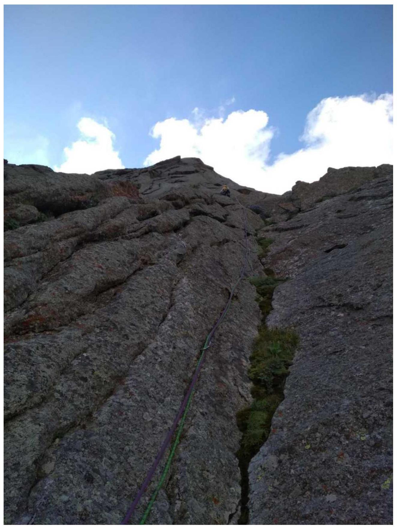
Section R2-R3 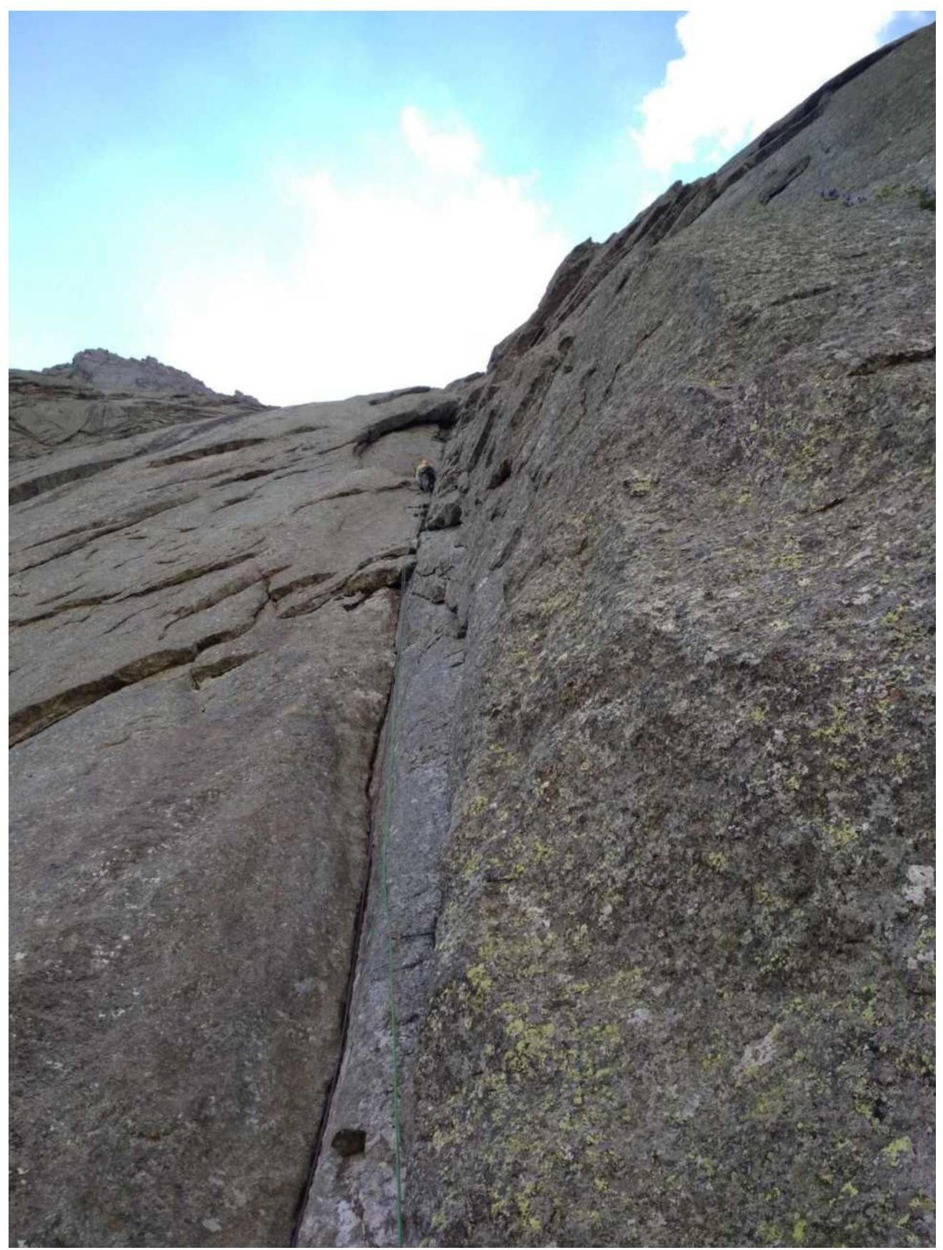
Section R4-R5 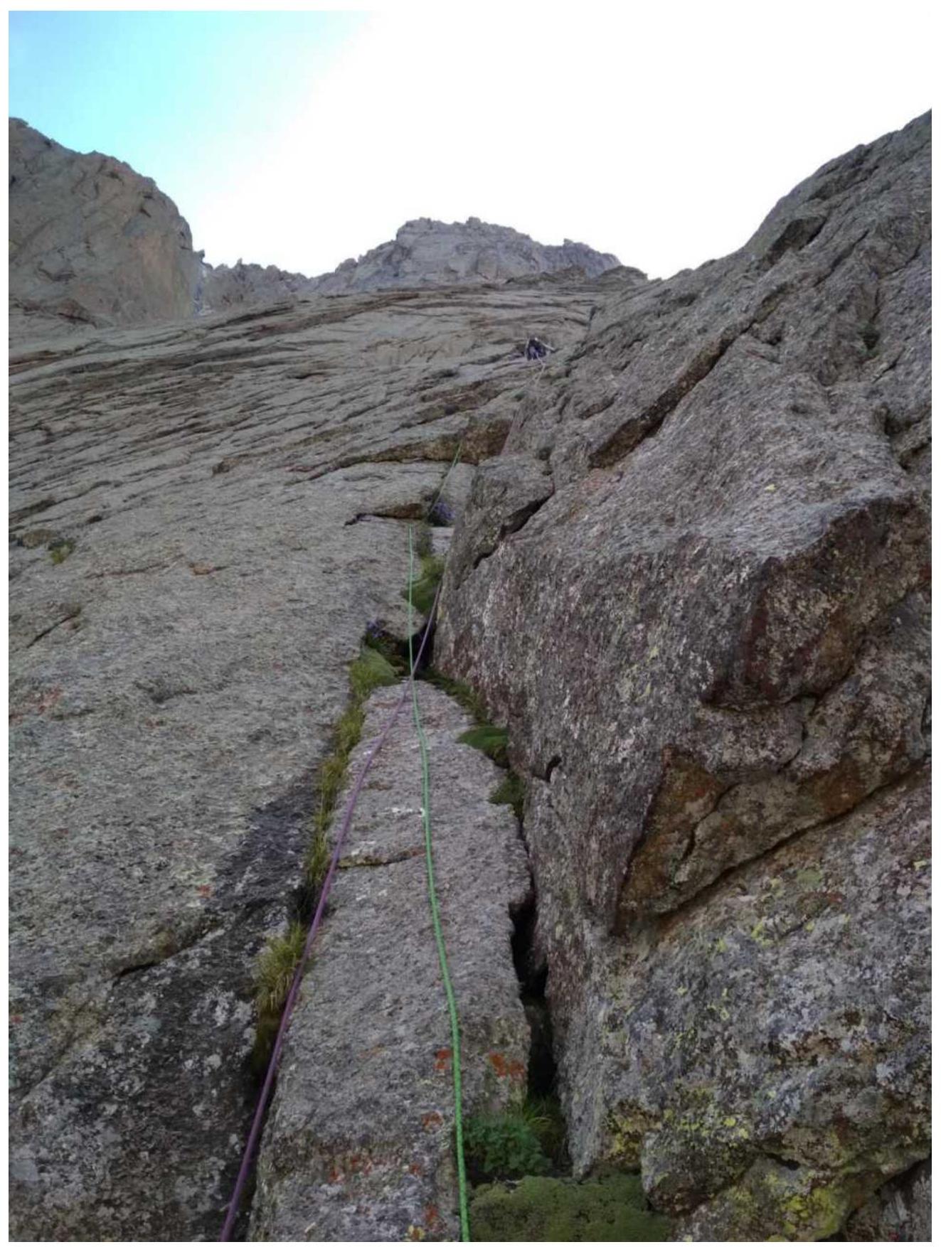
Section R6-R7 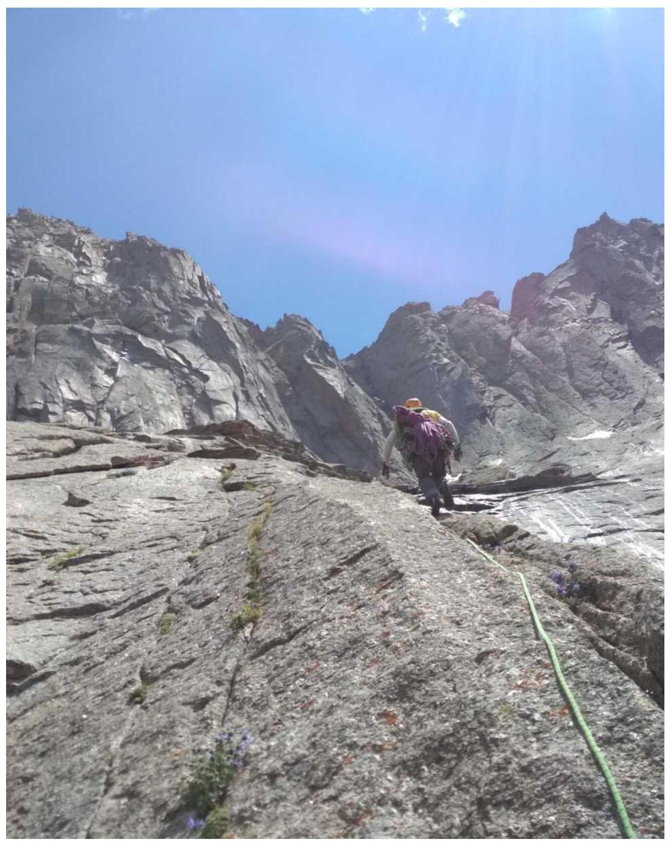
Section R11-R12 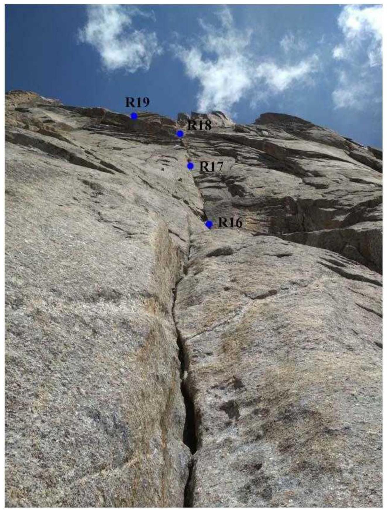
View from station R15 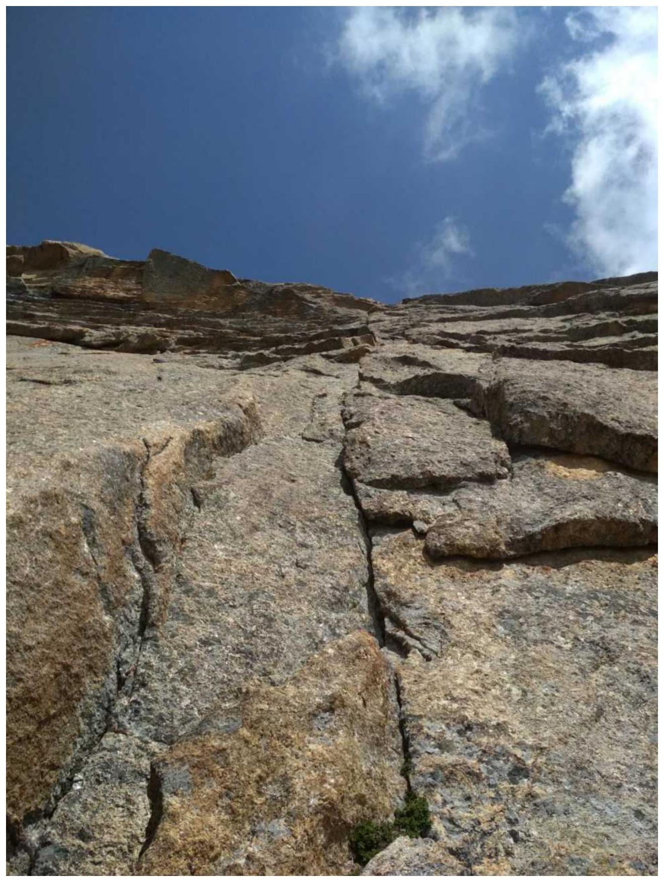
Section R17-R18 (key section of the route) 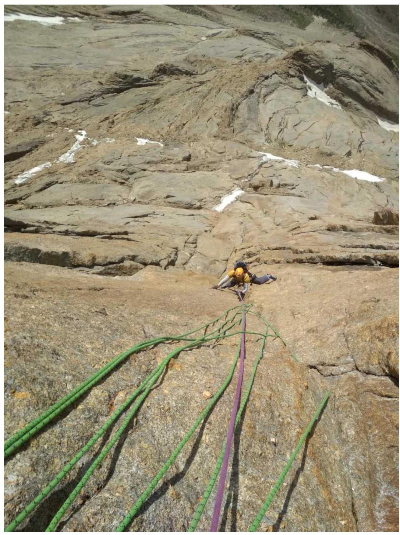
Section R17-R18 (photo from station R18, view from above) 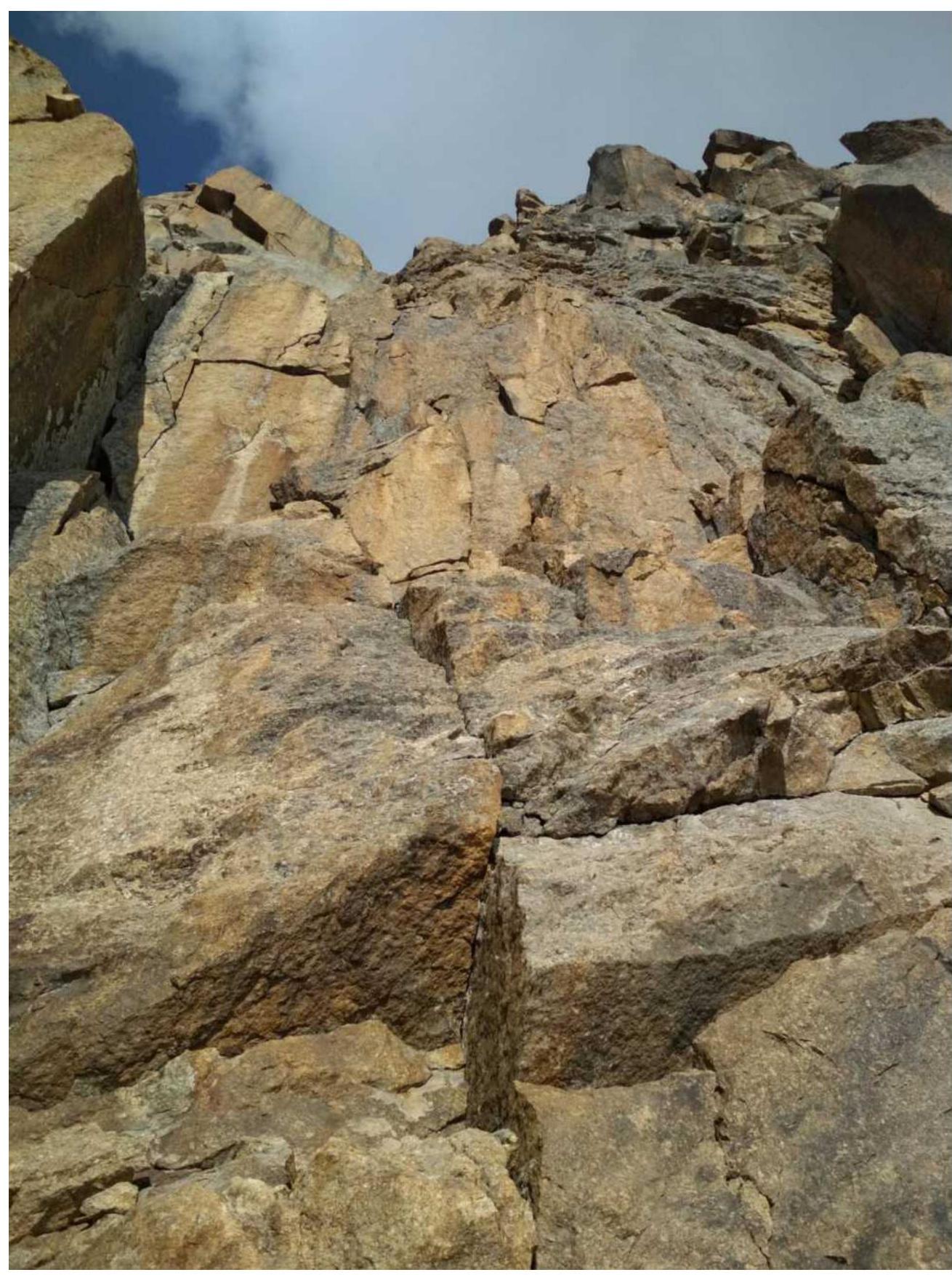
Section R19-R20 (start of the third bastion) 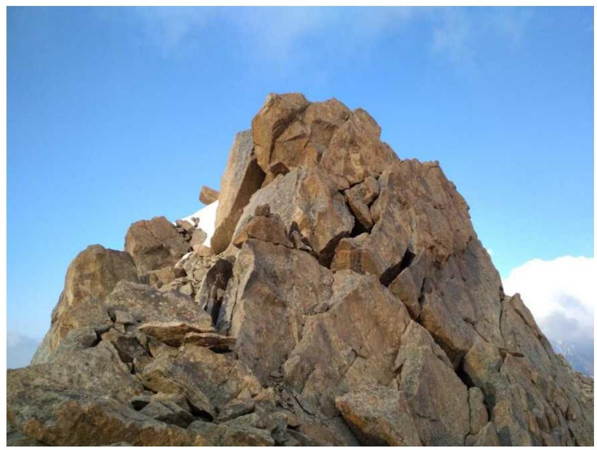
Summit 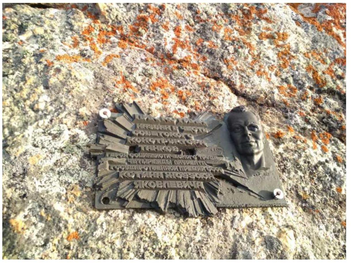
Summit plaque 
Note from Ivan Temerev's team, 2018 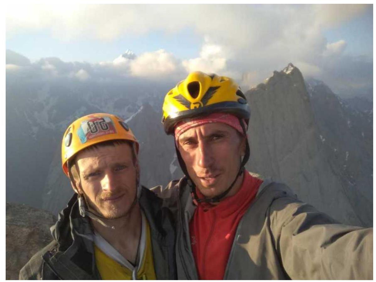
Summit 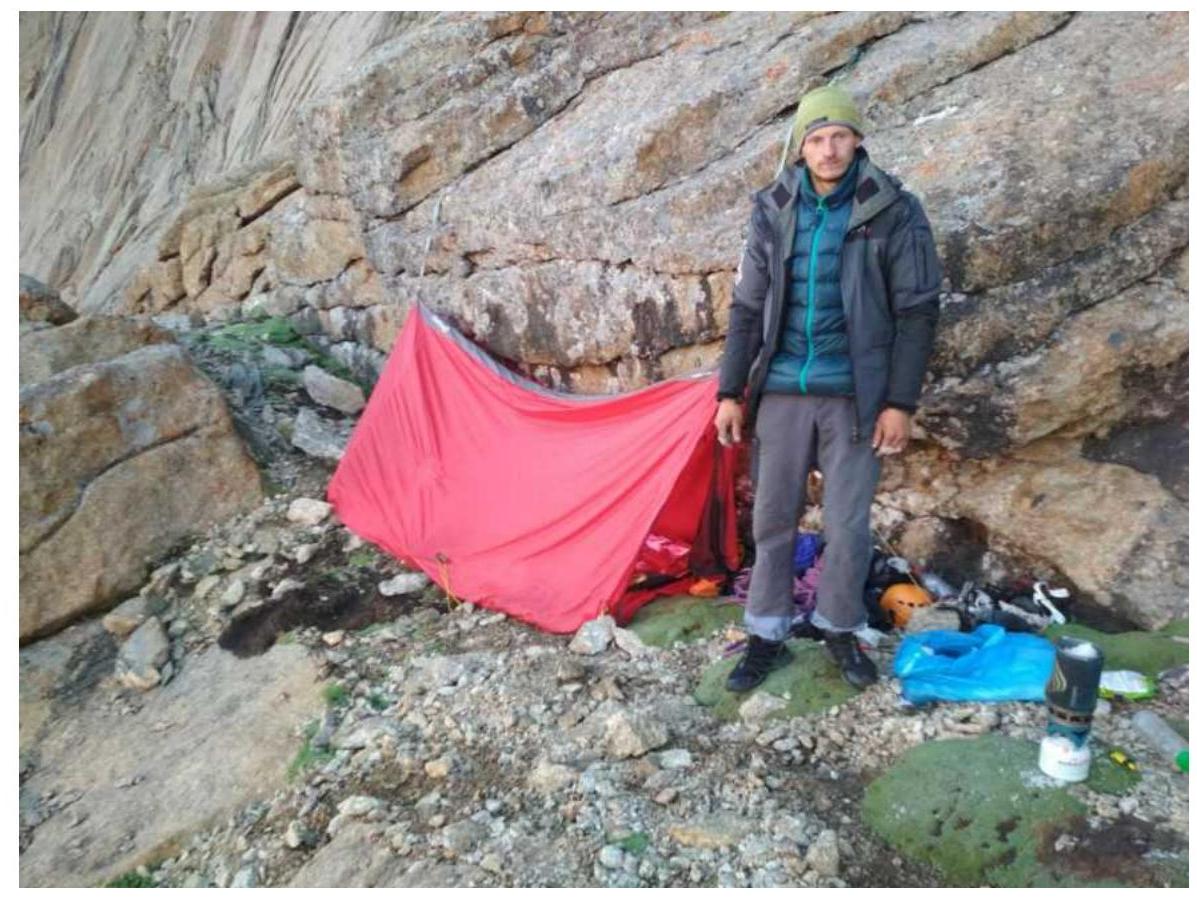
Overnight stay on descent at R13
3.3. Safety Assessment of the Route. Recommendations for Subsequent Climbers. Detailed Information on Descent from the Summit with Landmarks.
Equipment recommendations: double set of nut tools, friends up to size 3 (one size 3 and one size 4 can be used), 8-10 anchor hooks (some with a bend), rock shoes. It's recommended to use trekking gloves or tape for hand protection. A double rope of at least 60 m is recommended because the rappels on the lower bastion are 59-60 m long. The second rope can theoretically be replaced with a 60 m cordelette for rope retrieval. The route has sufficient ledges for a tent, so a lightweight tent, sleeping bag, and stove are optional.
Our route was completed entirely using free climbing by both participants (including the key 7a section) in one daylight period (descent and return to base camp on the next day). We consider the route to be safe and logical, with interesting climbing, diverse terrain, and a significant length.
In our opinion, the route deserves a category 5B rating because its difficulty is comparable to other classic Karavshin 5B routes, such as:
- Perestroika on Slesova Peak;
- Alperina on Asan Peak.
Perhaps in a different area, this could be considered 6A, but for Karavshin, the route lacks complex sections requiring artificial aids.
We believe the route is suitable for a pair of climbers with a good level of climbing ability and will provide them with a satisfying experience. We do not recommend the route as an acclimatization climb or as a first 5B due to its significant length and difficulty.
Description of the Descent
The description of the descent is taken from Ivan Temerev's report on the first ascent of Shaitankhana Peak via the "Operation KIK" route on the internal angle of the western wall and the center of the upper bastion, category 6A.
Descent from the summit can be done:
- Via the north ridge - Vasilkov's route, 4B (not recommended);
- Via a descent route established by foreign climbers directly down the western wall.
From the summit, move along the south ridge towards the "1000th anniversary of the Baptism of Rus'" (about 15 minutes of walking, just before R22). On your right, you'll see the first rappel anchor. Rappel 30 m.
Continue down the vague ridge to a cairn. From it, rappel diagonally right and down (three sections of 30 m). It's better not to combine sections to avoid rope jamming. Then, in the same direction, rappel onto an ossoid ledge (20 m). There's a white anchor on the wall.
From it, rappel straight down (two sections of 60 m). The last station before the first large ledge is on one anchor. Reinforce it with your gear. There might be another station to the right, but we didn't find it. From this point, rappel 25 m down to the ledge. There's a small platform under a micro-block a bit higher where you can camp.
We moved right along the ledge for no more than 50 m and found a white rope loop with a carabiner on two points on the wall to the right.
From it, rappel down four times:
- On the second rappel, there's a transition through a cornice where the rope can jam. It's a good idea to push the knot past it (easier with 60 m ropes);
- Better yet, place a piton above the cornice.
From the last rappel, move left down and along a small external angle with a terrace down to a ledge on foot.
Then, along a large ossoid to the left (250 m) to a camping platform near a rock (R13). From there, you can either descend on foot down to the right or rappel 20 m down a rocky ridge to a piton.
We set up a cairn towards the piton and descended on foot about 200 m. On the right side, there's a white loop on a stone.
From it, we rappelled diagonally left (60 m) through slabs and a cornice. Some say it's better to rappel straight down. There are three pitons. We placed our own anchor and rappelled vertically down 50 m.
To the right, slightly around the corner, there's a flake. We left our white loop on it. 30 m down to a ledge on a rocky ridge. From it, walk down to the right to a ridge and rappel down. Along it, about 15 m on foot. There's a loop, seemingly black. From here, about 9 rappels down:
- First, down and right. There's a loop at 30 m;
- Then, two rappels of 30 m;
- There are pitons with loops, but some are on flakes;
- Often, you need to rappel 60 m and secure the ropes on a "U" to allow the upper climbers to retrieve the ropes;
- Fifth section - left onto a ledge. Loop on a flake;
- From there, down and right;
- Piton under a cornice!;
- From it, right down;
- Piton;
- Vertically down.
Exit onto a walking ledge. Along the wall, left down (400 m). Cross two rocky ridges. Small descents. Exit onto a grassy slope.
Additions
Route scheme on one sheet 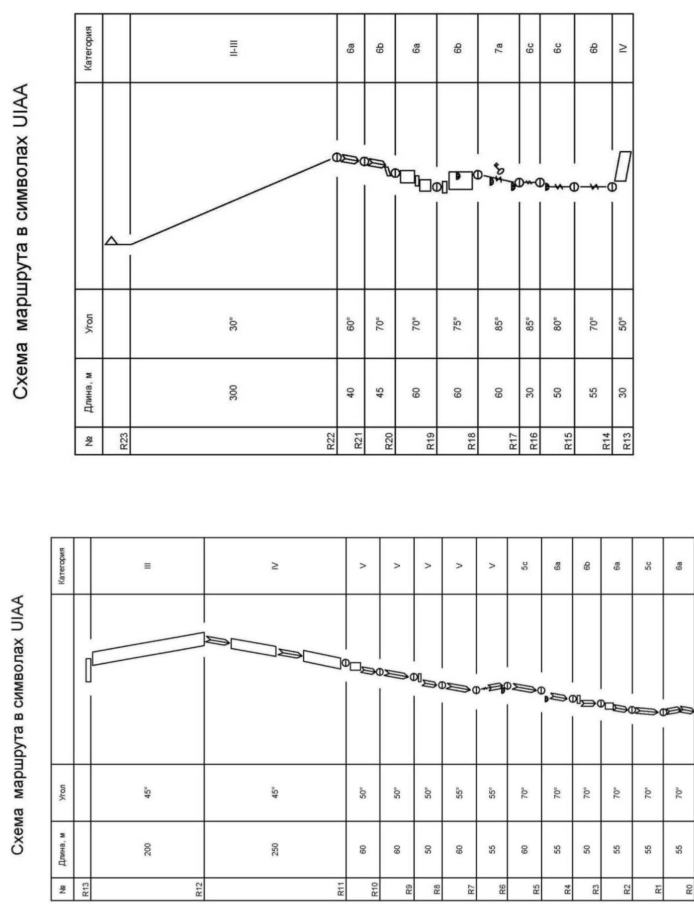
Additions
Brief description of route sections {started working on the route at 7:00}
- R0–R1: V – 30 m, 6a – 25 m, 7 friends, 3 anchors;
- R1–R2: 5c – 55 m, 3 friends, 7 anchors;
- R2–R3: V – 30 m, 6a – 25 m – 3 friends, 8 anchors;
- R3–R4: 6b (in sections) – 50 m, 5 friends, 6 anchors;
- R4–R5: 6a – 55 m, 10 friends, 2 anchors;
- R5–R6: 5c – 60 m, 8 friends, 2 anchors;
- R6–R7: V – 55 m, 5 friends, 4 anchors;
- R7–R8: V – 60 m, 5 friends, 5 anchors;
- R8–R9: V – 50 m, 5 friends, 4 anchors;
- R9–R10: V – 60 m, 6 friends, 4 anchors;
- R10–R11: V – 60 m, 6 friends, 3 anchors;
- R11–R12: IV (with sections of V) – 250 m (200 m), 12 friends and 5 anchors;
- R12–R13: III – 180 (200 m). {end of the first bastion, left bivouac on the ledge. Time 14:00}
- R13–R14: IV – 30 m, 4 friends;
- R14–R15: 6b – 55 m, 8 friends, 2 anchors;
- R15–R16: 6c – 50 m, 8 friends, 6 anchors;
- R16–R17: 6c – 30 m, 9 friends, 1 anchor;
- R17–R18: 7a – 40 m (key section), 6a – 20 m, 8 friends, 8 anchors;
- R18–R19: 6a – 30 m, 6b – 30 m, 3 friends, 7 anchors. {station on the ledge separating the 2nd and 3rd bastions. Time 17:30}
- R19–R20: V – 20 m, 6a – 40 m – 6 friends, 3 anchors;
- R20–R21: V – 20 m, 6b – 25 m, 7 friends;
- R21–R22: 6a – 40 m, 8 friends. {exit onto the ridge. Time 19:30}
- R22–R23: II–III – 300 m (with sections up to V) – ridge. {summit reached at 19:55}
Used on the route: 131 friends, 121 anchor hooks.