Ascent Passport
- Climbing category — technical.
- Climbing region — Pamir-Altai, Turkestan Range.
- p. 4490 m («Ptitsa») via the central counterfort of the N wall.
- Proposed — 6B category of difficulty, first ascent.
- Height difference — 780 m, length — 810 m.
Length — 5–6 category of difficulty — 630 m, out of which 6 category of difficulty — 450 m. Average steepness — 72° (3710–4490), steepness of the wall section 77° (3760–4390).
- Pitons hammered in:
- rock: 131, out of which 94 removed
- bolt: 8, out of which 4 removed
- chocks: 163, out of which 110 removed
- Number of climbing hours — 30.5, days — 5.
- Overnights: two, 1st semi-reclined, 2nd — good on two adjacent ledges.
- Leader: Mayorov Evgeny Evgenievich, Master of Sports Team members: Robikov Dmitry Grigorievich, Candidate for Master of Sports; Kozyrev Vladimir Nikolaevich, Candidate for Master of Sports; Borodin Vladimir Vasilyevich, Candidate for Master of Sports; Alenchev Alexander Nikolaevich, Candidate for Master of Sports; Gavrilov Mikhail Viktorovich, Candidate for Master of Sports
- Team coach: Chunovkin Gury Alexandrovich, Honored Coach of the RSFSR.
- Approach to the route — July 22, 1989; Summit reached — July 26, 1989; Return — July 26, 1989.
- Organization — «Mayak» Club of Alpinists and Rock Climbers.
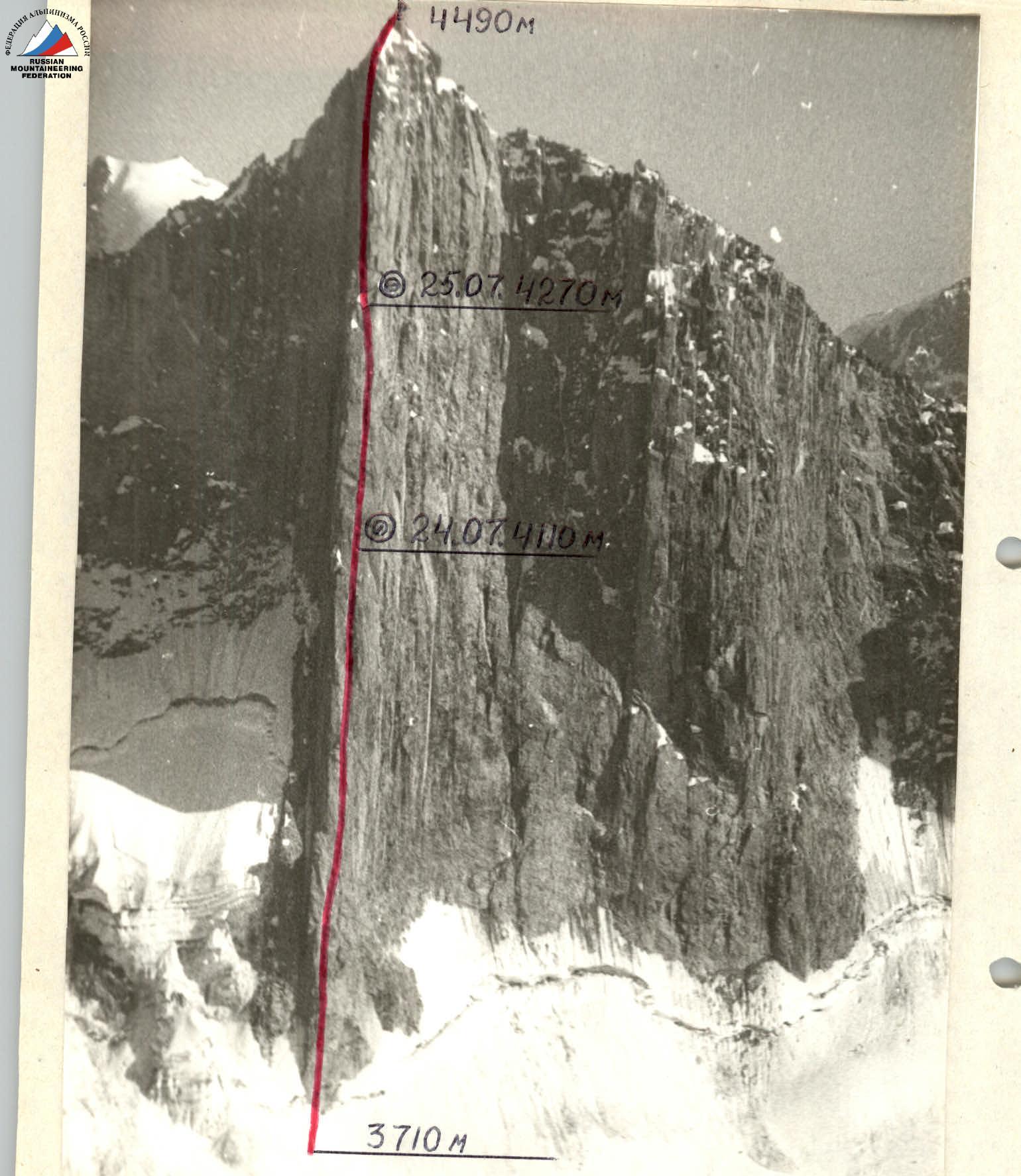 «Photo 1. General photo of the summit. July 22, 1989, 14:00, objective lens. T-43, focal length 40 mm, 1000 m, shooting point 1, 3750 m. — Via the central counterfort of the N wall, approximately 6B category of difficulty, 1989, team leader Mayorov E. E.»
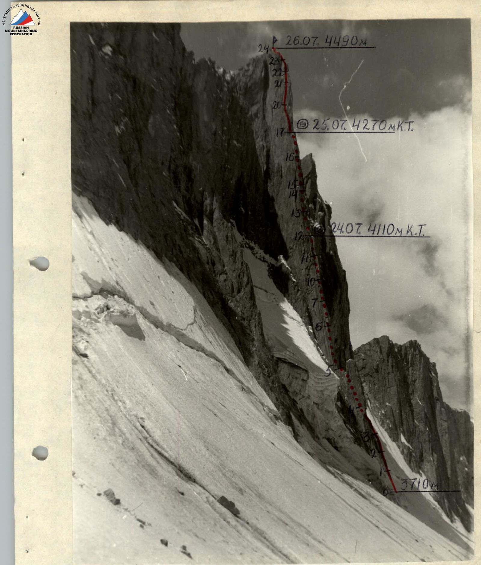 «Photo 2. Profile of the wall from the left. July 22, 1989, 15:40, objective lens. T-43, focal length 40 mm, 1000 m, shooting point 3, 3500 m.»
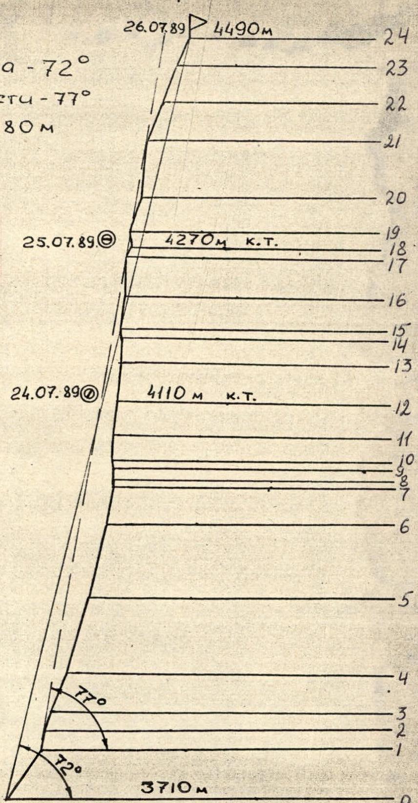 «Legend: R0–R24 — section numbers; @ — bivouac location; К. Т. — control cairn. Route profile M 1:4000. Average steepness — 72°. Steepness of the wall section — 77°. Height difference — 780 m.»
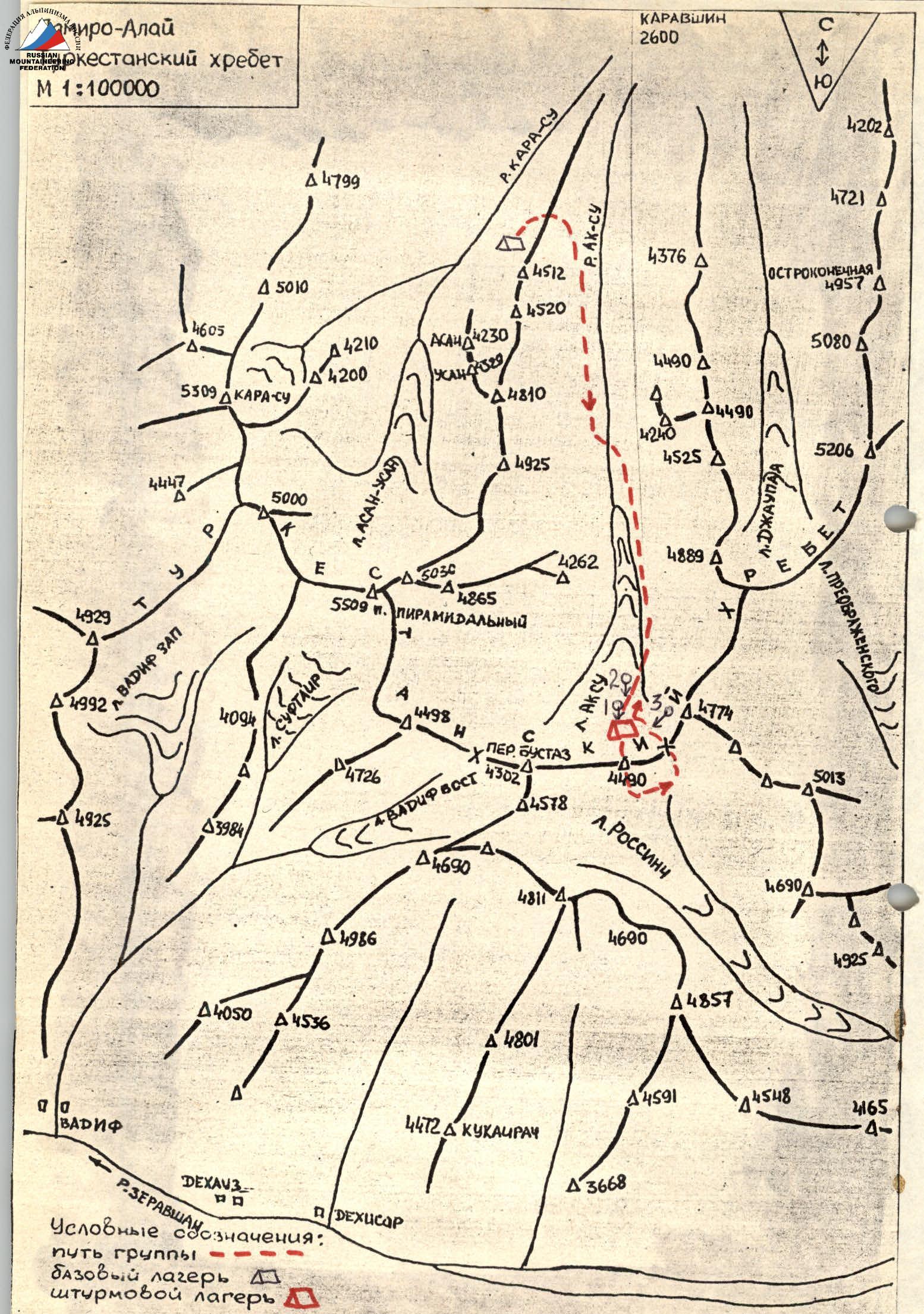 «Legend: path of the group; base camp; assault camp.»
Tactical Actions of the Team
The determining factors when drawing up the tactical plan were:
- technical difficulty of the route throughout its entire length;
- remoteness of the summit from the base camp (organization of radio communication);
- unstable weather conditions.
Taking into account good physical and technical preparation and based on the above factors, a tactical plan was developed for the ascent with two overnight stays on the route. The proposed overnight locations were determined during a reconnaissance sortie.
On July 21, 1989, at 11:30, the team left the base camp located in the Kara-Su gorge. At 13:30, they made a halt at the foot of p. 4240 (Slesova Peak) in the Ak-Su gorge and at 14:00 continued moving towards p. 4490.
July 22, 1989:
- After observation, the route to the summit was clarified.
- At 12:00, the rope team Alenchev–Gavrilov started processing the route.
- At 13:00, they began work on the route (photo 5).
- By 15:30, they had completed 2 ropes (sections 1–4), examined the further path of movement, and descended.
According to the regulations of the Leningrad Championship, it is allowed to process 100 m of the route.
This year, the weather in the area is very unstable. Already at 16:00, the sun disappeared. First, graupel started falling, then wet snow, followed by a thunderstorm. All this continued until 10:00 the next day. July 23, 1989. The entire route was covered in wet snow, with water flowing down the walls. Therefore, it was decided not to proceed with the route and wait for the wall to clear.
July 24, 1989. At 8:00, the team left the bivouac, and at 10:30, Alenchev–Gavrilov continued working on the route. They covered sections 4–7 (photo 6). At 16:00, they were replaced by Mayorov–Borodin. At 18:00, the group reached the intended overnight location (sections 12–13). Mayorov–Borodin continued processing the route (sections 12–14) and descended to the overnight stay at 21:00.
July 25, 1989. No sun. Overcast, graupel, snow, wind, cold. The entire sky is covered with clouds. At 10:00, Robikov–Kozyrev began further movement along the route (photos 10, 11). The route demands not only physical strength but also all technical means for advancement.
At 19:00, the group reached the second overnight stay (sections 17–18), and Kozyrev–Robikov continued processing the route. Throughout the day, with intermittent breaks, graupel and snow fell. At 20:30, the rope team descended, having processed section 18–19.
July 26, 1989. They waited for a change in weather, but there was no improvement. Graupel and snow continued to fall with short breaks.
At 10:00, Alenchev–Gavrilov continued working on the route. By 15:00, the last complex section was completed (sections 20–21). At 17:00, the group reached the summit.
At 17:30, they began descending southward along the ridge, approximately 1B category of difficulty, and then through the pass between p. 4490 and p. 4774, the team returned to the Ak-Su glacier. The descent took 2 hours and 30 minutes. On July 27, 1989, the team returned to the base camp in the Kara-Su gorge.
The length of the route was 810 m, out of which:
- 5–6 category of difficulty — 630 m.
The route was completed in 30.5 hours. Control cairns were left at the overnight stays and the summit. The group was under regular observation through binoculars, and constant radio communication was maintained. When passing the most complex sections lacking crevices and relief for movement, skyhooks were used.
Safety during movement on the route was ensured by:
- all participants moving on a double rope;
- selection of safe overnight locations;
- quality equipment;
- a correctly composed tactical plan.
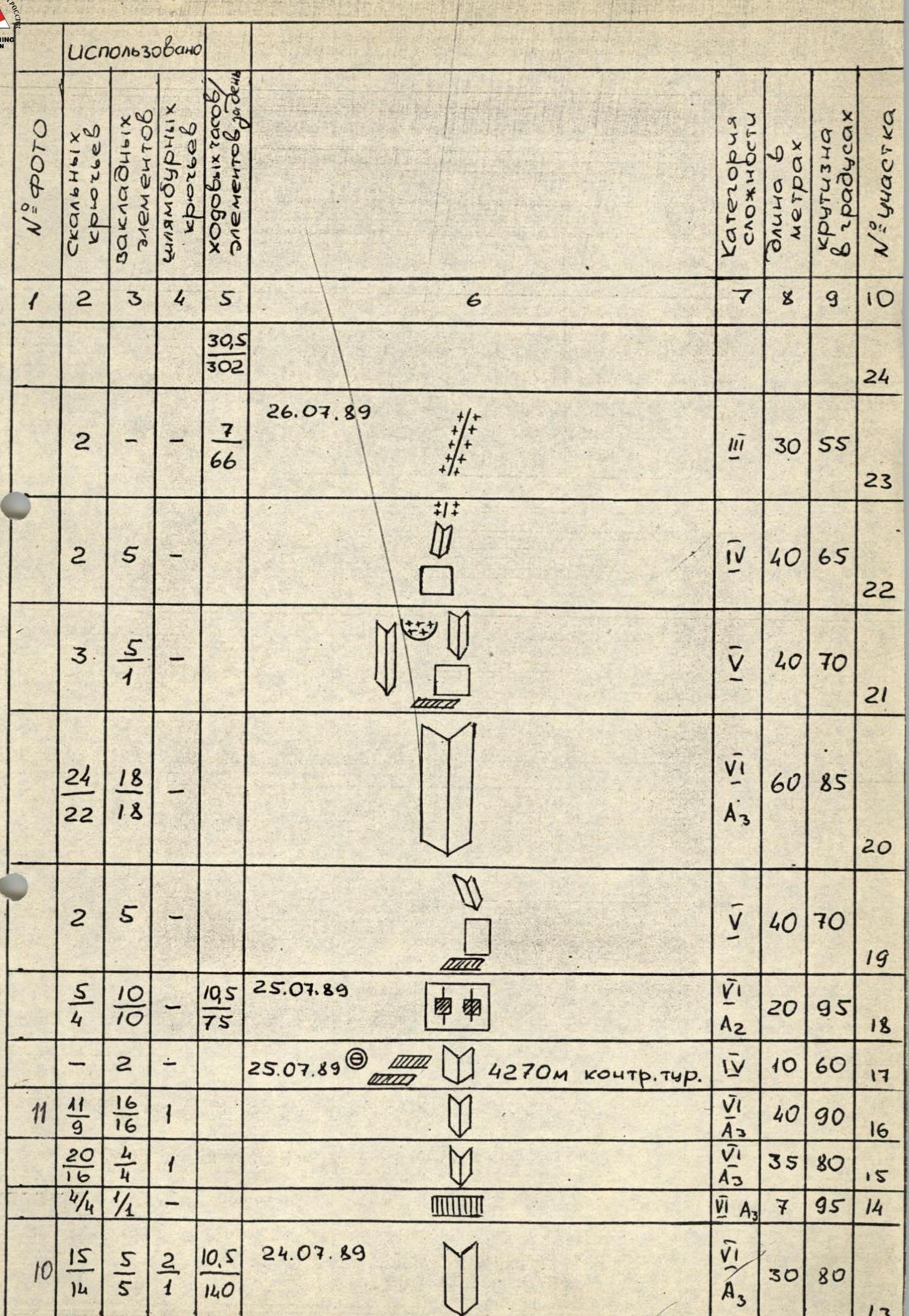
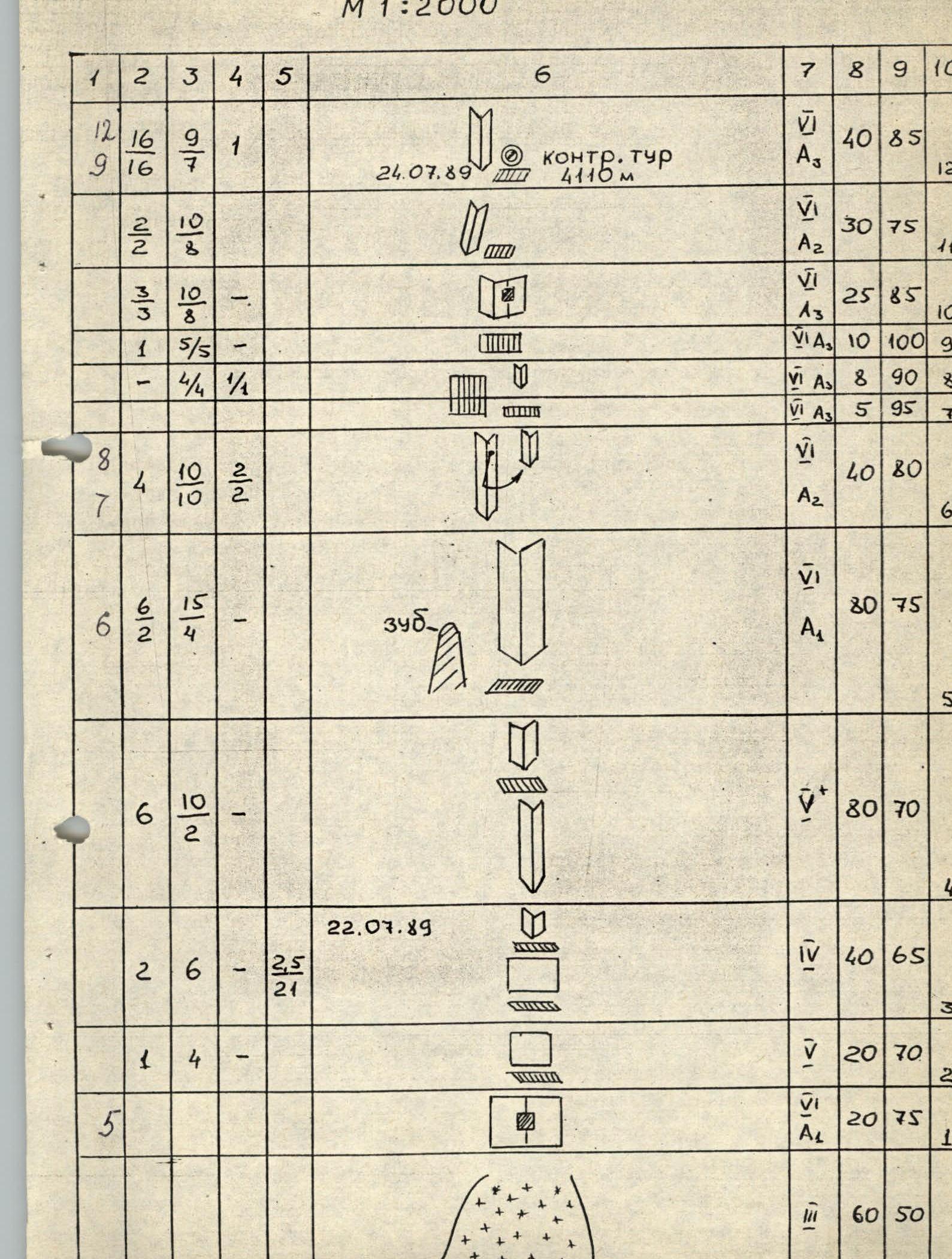 «Route diagram in symbols M 1:2000.»
 «— 8а —»
Route Description by Sections
The route is straightforward and represents a vertical internal corner that runs practically from the start of the route to the summit. From the bottom to the second overnight stay, the route passes on the right side of the main counterfort, and after the overnight stay — on its left side.
Section R0–R1.
- Steep snow slope ending in a deep bergschrund.
Section R1–R2.
- Slab with a crack, passable using artificial aids (ITO).
- Climbing is very difficult.
Section R2–R3. Up the slab to a small ledge. Climbing is difficult.
Section R3–R4. Up the slab, then up the internal corner to the right. Rich relief for climbing.
Section R4–R5. Up the internal corner towards the large internal corner to the right of the «Tooth» standing away from the wall. It is possible to organize an overnight stay behind the «Tooth». Climbing is difficult.
Section R5–R6. Straight up the internal corner to a small ledge. The walls of the corner are smooth. Climbing is very difficult. Some sections on ITO.
Section R6–R7. Up the left internal corner, then pendulum to the right and up the internal corner with a crack (friends) under the cornice.
Section R7–R8. Through the cornice on ITO.
Section R8–R9. Up the vertical internal corner under the next cornice.
Section R9–R10. Through the cornice on ITO towards the crack on the right face of the internal corner.
Section R10–R11. Up the crack on ITO to a small ledge. Climbing is very difficult.
Section R11–R12. Up the internal corner to the left of the ledge to a narrow snow-covered ledge. Location of the first overnight stay. A control cairn is in the crack above the ledge.
Section R12–R13. To the left of the overnight stay, up the steep internal corner. The left face of the corner is vertical. Climbing is very difficult. Practically all the time on ITO.
Section R13–R14. Up the internal corner under the cornice. Climbing is very difficult. Relief is minimal. Very often on ITO.
Section R14–R15. Through the cornice on the left part on ITO.
Section R15–R17. Up the vertical internal corner. Climbing is very difficult. Practically all the time on ITO.
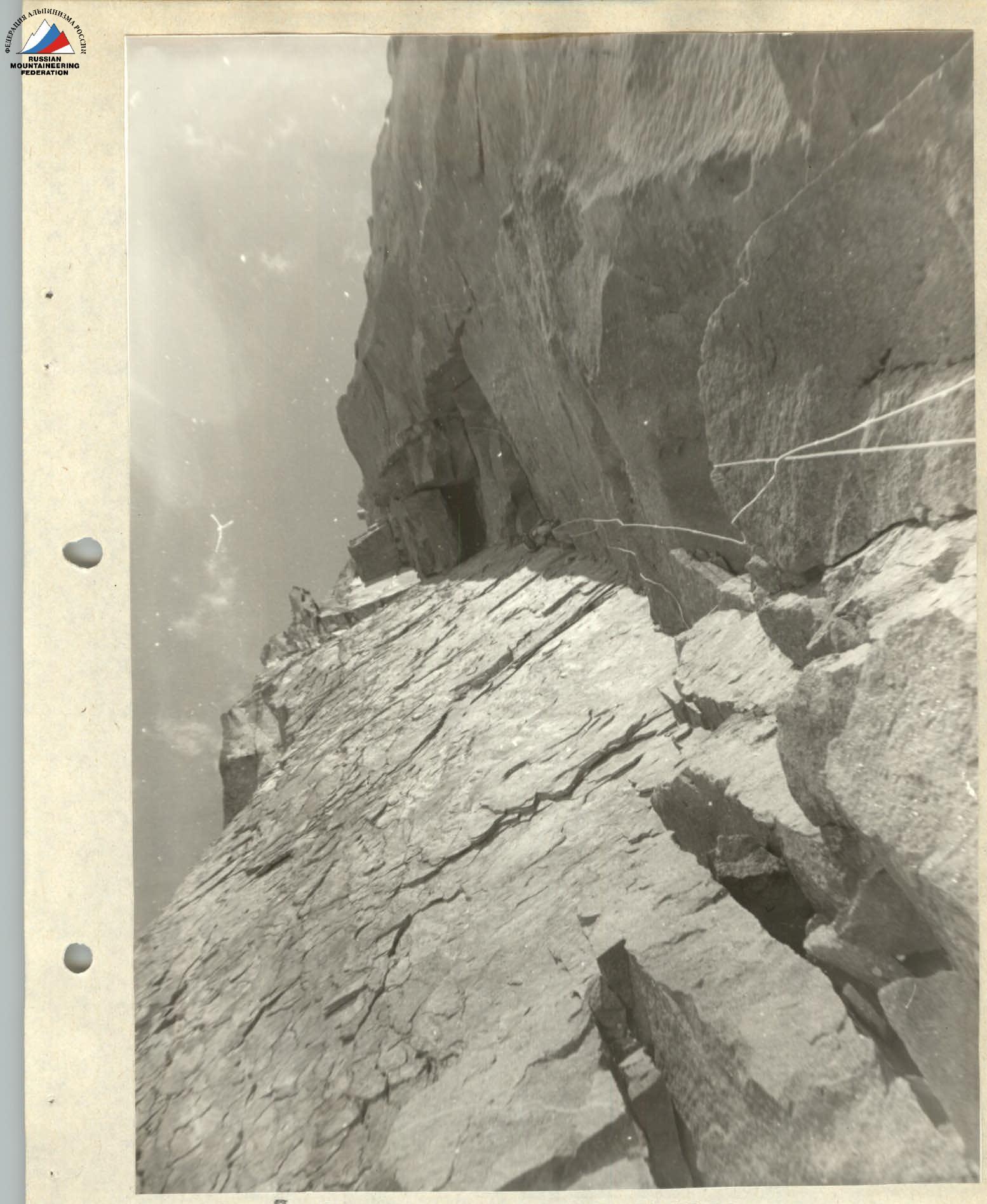
Section R17–R18. Up the internal corner to the overhanging wall with two cracks. Midway through the section is a location for an overnight stay on two ledges, one above the other. Second control cairn here.
Section R18–R19. Up the overhanging wall to a small ledge. Climbing is very difficult, often on ITO.
Section R19–R20. 5 m to the right along the ledge, then up the slab and further up the internal corner. Climbing is difficult but with rich relief.
Section R20–R21. Up the vertical internal corner to a ledge. Climbing is very difficult. Often on ITO.
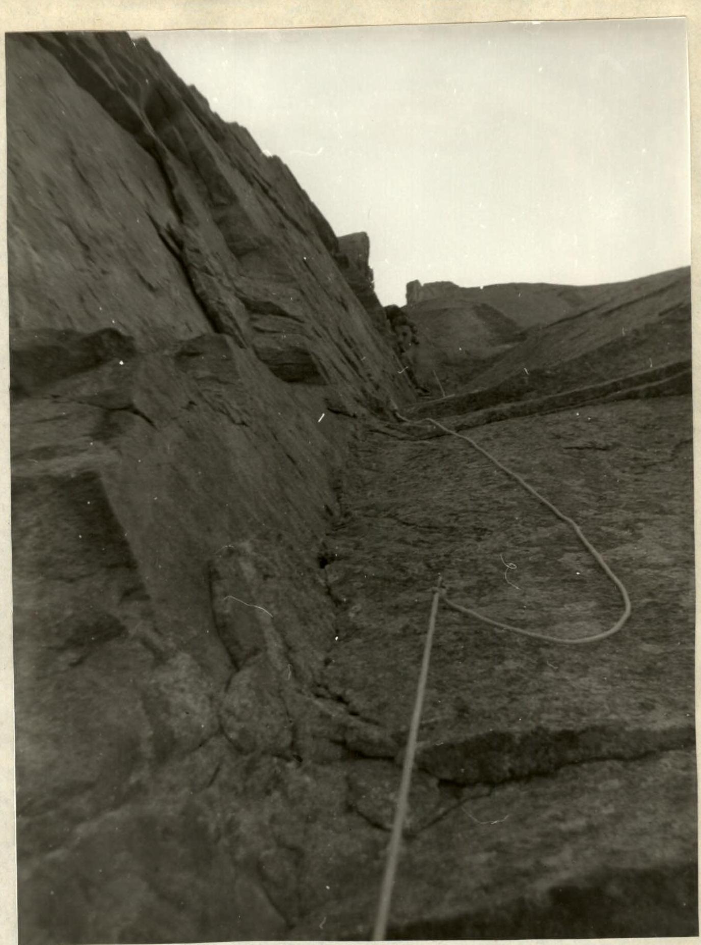
Section R21–R22. First up the slab, then bypassing the snow cornice to the right, up the internal corner towards the ridge. Climbing is confident.
Section R22–R23. First up the wall, then up the internal corner and further along the ridge. Climbing is not very difficult. Snow lies on the rocks in some places.
Section R23–R24. Along the ridge to the summit. Climbing is easy.
 «Photo 7. Cornice ahead, sections 6–7, July 24, 1989, 14:40, objective lens. T-43, focal length 40 mm.»
 «Photo 10. Up the internal corner, sections 13–14, July 25, 1989, 12:00, objective lens. T-43, focal length 40 mm.»
 «Photo 11. Through a small overhang, sections 16–17, July 25, 1989, 17:00, objective lens. T-43, focal length 40 mm.»