Ascent Passport
- Ascent category — technical.
- Ascent area — Pamir-Alay, Turkestan Range.
- Peak 4490 m («Ptitsa») via the central buttress of the N wall.
- Proposed category — 6B, first ascent.
- Height difference — 780 m, length — 810 m.
Length of 5–6 category sections — 630 m, of which 6 category — 450 m. Average steepness — 72° (3710–4490), steepness of the wall section — 77° (3760–4390).
- Pitons hammered in:
| Type | Primary | Additional |
|---|---|---|
| rock | 131 | 94 |
| bolt | 8 | 4 |
| chocks | 163 | 110 |
- Movement time — 30.5 hours, days — 5.
- Overnights: two, 1st semi-reclined, 2nd — good on two adjacent ledges.
- Team leader: Evgeny E. Mayorov, Master of Sports
Team members: Dmitry G. Robikov, Candidate for Master of Sports, Vladimir N. Kozyrev, Candidate for Master of Sports, Vladimir V. Borodin, Candidate for Master of Sports, Alexander N. Alenchev, Candidate for Master of Sports, Mikhail V. Gavrilov, Candidate for Master of Sports
- Team coach: Guriy A. Chunovkin, Honored Coach of the RSFSR.
- Approach to the route — July 22, 1989; Summit — July 26, 1989; Descent — July 26, 1989.
- Organization — «Mayak» Climbers and Rock Climbers Club.
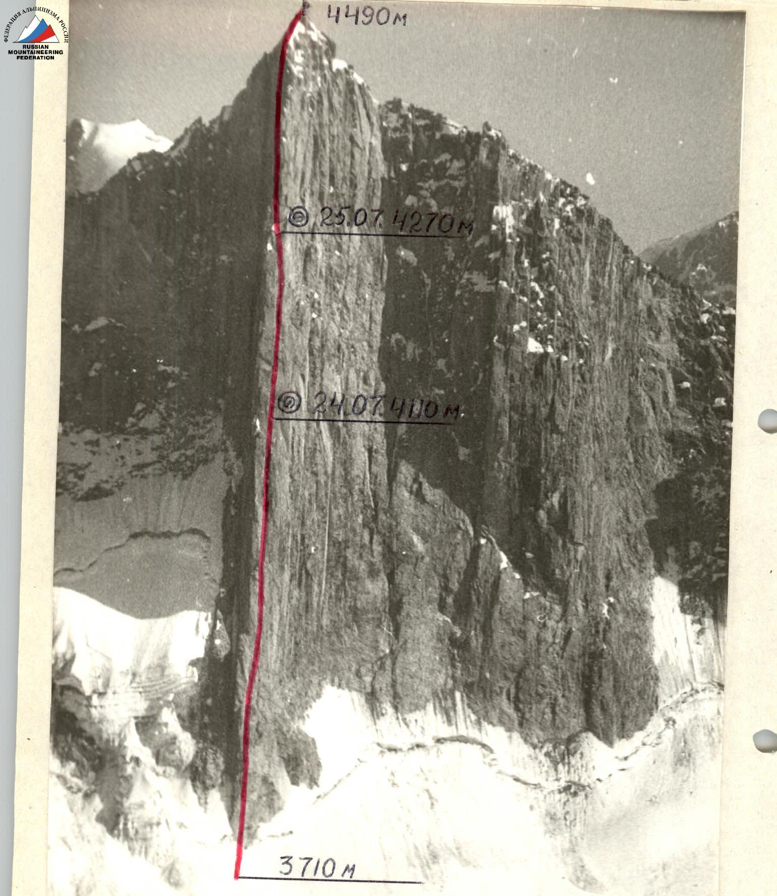
Photo 1. General photo of the summit. July 22, 1989, 14:00, lens T-43, focal length 40 mm, 1000 m, shooting point 1, 3750 m.
— via the central buttress of the N wall, approximately 6B category, 1989, team leader Mayorov E.E.
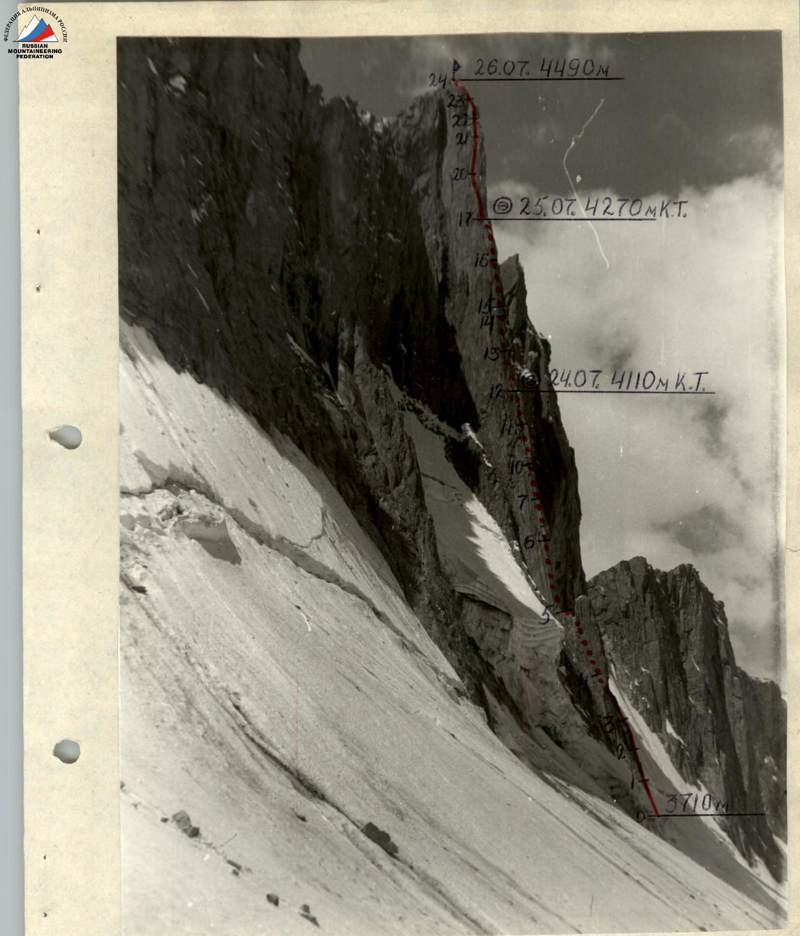
Photo 2. Wall profile from the left. July 22, 1989, 15:40, lens T-43, focal length 40 mm, 1000 m, shooting point 3, 3500 m.
Conventions: R0–R24 — section numbers; (0) — overnight location; К.Т. — control point.
Route profile M 1:4000. Average steepness — 72°. Steepness of the wall section — 77°.
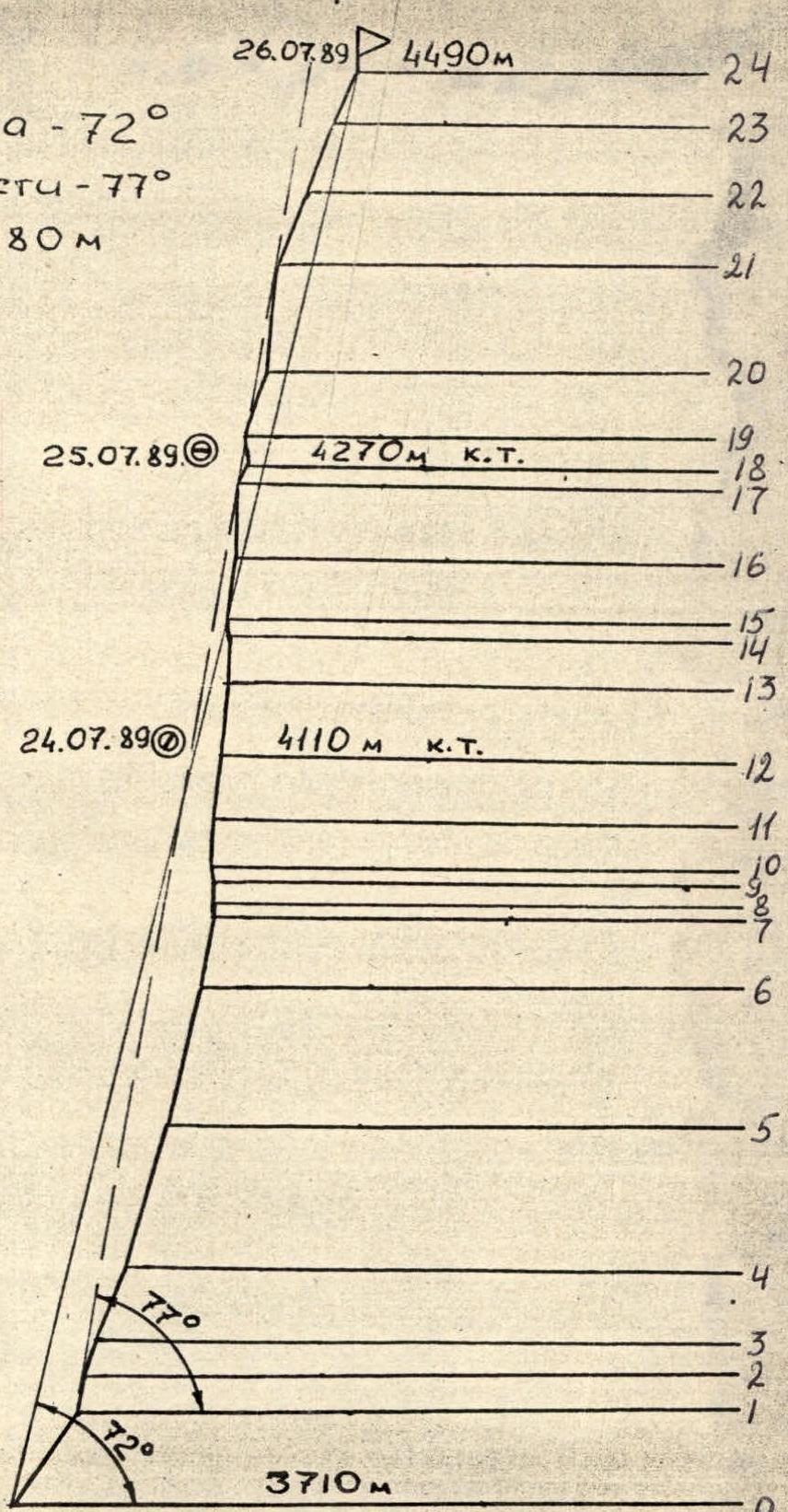
Conventions: R0–R24 — section numbers; (3) — bivouac location; К.Т. — control point.

Team Tactics
The determining factors when drawing up the tactical plan were:
- technical difficulty of the route along its entire length;
- remoteness of the summit from the base camp (organization of radio communication);
- unstable weather conditions.
Considering the good physical and technical preparation of the team and based on the above factors, a tactical plan was developed for the ascent with two overnight stops on the route. The proposed overnight locations were identified during a reconnaissance sortie.
On July 21, 1989, at 11:30, the team left the base camp located in the Kara-Su gorge. At 13:30, they made a halt at the foot of Peak 4240 (Slesova Peak) in the Ak-Su gorge and at 14:00 continued moving towards Peak 4490.
July 22, 1989. After observation, the route to the summit was clarified. At 12:00, the rope team Alenchev—Gavrilov started processing the route. At 13:00, they began work on the route (photo 5). By 15:30, they had completed 2 ropes (R1–R4), reviewed the further path, and descended.
According to the regulations of the Leningrad Championship, processing up to 100 m of the route is allowed.
This year, the weather in the area has been very unstable. By 16:00, the sun had disappeared. Initially, it started snowing small pellets, followed by wet snow, and a thunderstorm. This continued until 10:00 the next day.
July 23, 1989. The entire route was covered in wet snow, with water flowing down the walls. Therefore, it was decided not to start the ascent and wait for the wall to clear.
July 24, 1989. At 8:00, the team left their bivouac, and at 10:30, Alenchev—Gavrilov continued working on the route. They completed sections R4–R7 (photo 6). At 16:00, they were replaced by Mayorov—Borodin. At 18:00, the group reached the proposed overnight location (R12–R13). Mayorov—Borodin continued processing the route (R12–R14) and descended to the overnight location at 21:00.
July 25, 1989. No sun. Overcast, snowing small pellets, snow, wind, cold. The entire sky was covered in clouds. At 10:00, Robikov—Kozyrev began further movement along the route (photos 10, 11). The route demanded not only physical strength but also all technical means for advancement. At 19:00, the group reached the second overnight location (R17–R18), and Kozyrev—Robikov continued processing the route. Throughout the day, with intervals, it snowed small pellets and snow. At 20:30, the rope team descended, having processed section R18–R19.
July 26, 1989. They waited for a change in weather, but there was no improvement. It continued to snow and snow small pellets with short breaks. At 10:00, Alenchev—Gavrilov continued working on the route. By 15:00, they had completed the last challenging section (R20–R21). At 17:00, the group reached the summit.
At 17:30, they began descending southwards along the ridge, approximately category 1B. Then, through the pass between Peak 4490 and Peak 4774, the team returned to the Ak-Su glacier. The descent took 2 hours and 30 minutes. On July 27, 1989, the team returned to the base camp in the Kara-Su gorge.
The route length was 810 m, of which 5–6 category sections were 630 m.
The route was completed in 30.5 hours. Control points were left at the overnight locations and the summit. The group was under regular observation through binoculars, and constant radio communication was maintained. When passing the most challenging sections lacking cracks and relief for movement, skyhooks were used.
Safety during movement on the route was ensured by:
- all participants moving on a double rope;
- selection of safe overnight locations;
- quality equipment;
- a correctly drawn-up tactical plan.
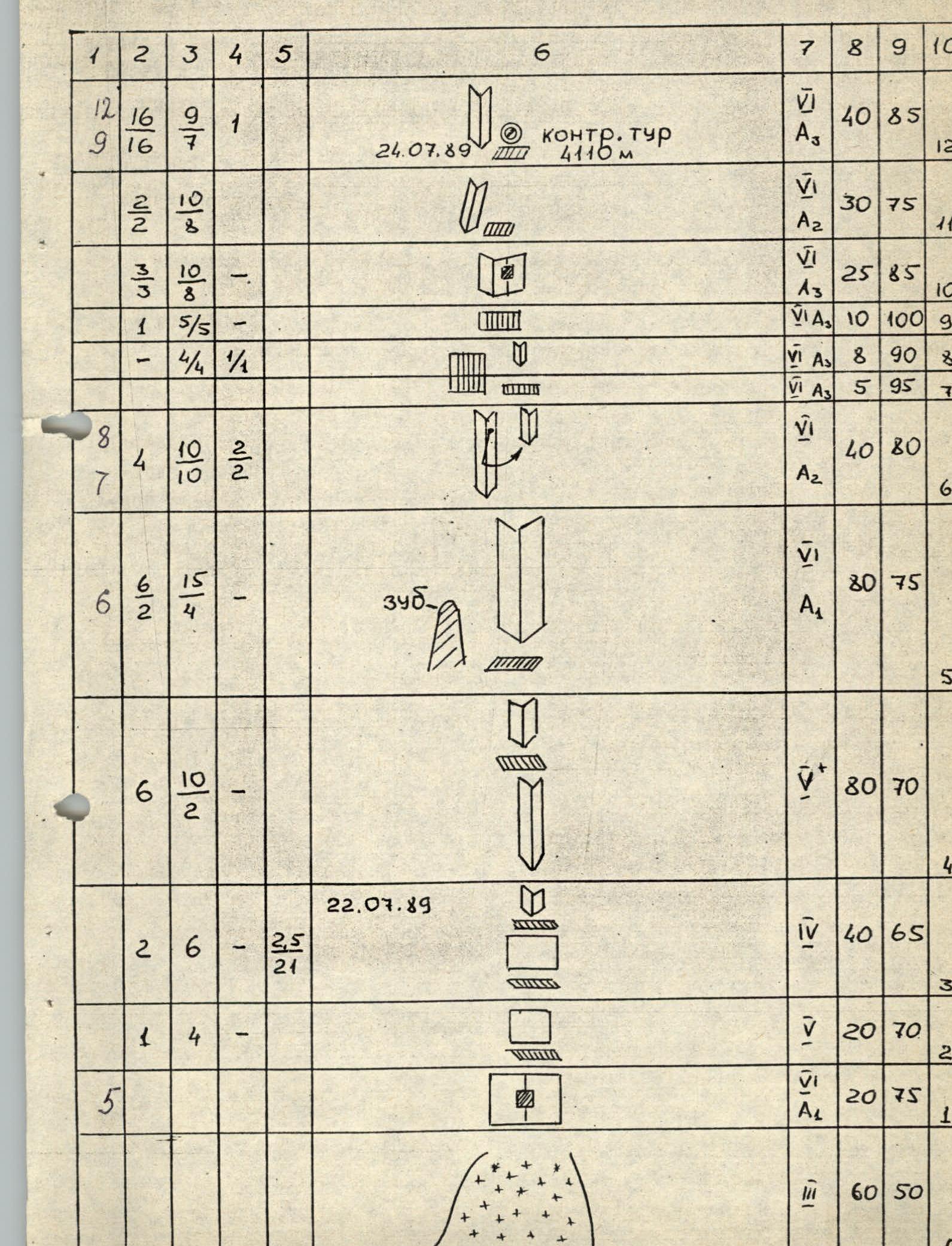
Route diagram in M 1:2000 symbols

Route Description by Sections
The route is straightforward and represents a vertical internal corner that runs practically from the start of the route to the summit. From the bottom to the second overnight location, the route passes on the right side of the main buttress, and after the overnight location — on its left side.
Section R0–R1. Steep snow slope ending in a deep bergschrund.
Section R1–R2. Slab with a crack, passed using artificial aids. Climbing is very challenging.
Section R2–R3. Up the slab to a small ledge. Climbing is challenging.
Section R3–R4. Up the slab, then along the internal corner to the right. Rich terrain for climbing.
Section R4–R5. Along the internal corner towards a large internal corner to the right of the «Tooth» protruding from the wall. It is possible to organize an overnight location behind the «Tooth». Climbing is challenging.
Section R5–R6. Straight up the internal corner to a small ledge. The walls of the corner are smooth. Climbing is very challenging.
Some sections use artificial aids. Section R6–R7. Up the left internal corner, then a pendulum move to the right and along the internal corner with a crack (friends) under the cornice.
Section R7–R8. Through the cornice using artificial aids.
Section R8–R9. Along the vertical internal corner under the next cornice.
Section R9–R10. Through the cornice using artificial aids towards a crack on the right face of the internal corner.
Section R10–R11. Along the crack using artificial aids to a small ledge. Climbing is very challenging.
Section R11–R12. Along the internal corner to the left of the ledge up to a not very wide snow-covered ledge. First overnight location. A control point is left in the crack above the ledge.
Section R12–R13. To the left of the overnight location, up the steep internal corner. The left face of the corner is vertical. Climbing is very challenging. Mostly using artificial aids.
Section R13–R14. Up the internal corner under the cornice. Climbing is very challenging. Terrain is sparse. Often using artificial aids.
Section R14–R15. Through the cornice on the left side using artificial aids.
Section R15–R17. Up the vertical internal corner. Climbing is very challenging. Mostly using artificial aids.
Section R17–R18. Along the internal corner to an overhanging wall with two cracks. In the middle of the section, there is a place for an overnight on two ledges, one above the other. Second control point.
Section R18–R19. Up the overhanging wall to a small ledge. Climbing is very challenging, often using artificial aids.
Section R19–R20. Along the ledge 5 m to the right, then up the slab and further along the internal corner. Climbing is challenging but with rich terrain.
Section R20–R21. Up the vertical internal corner to a ledge. Climbing is very challenging. Often using artificial aids.
Section R21–R22. Initially up the slab, then, bypassing a snow cornice on the right, along the internal corner towards the ridge. Climbing is confident.
Section R22–R23. Initially along the wall, then along the internal corner, and further along the ridge. Climbing is not very challenging. There is snow on the rocks in some places.
Section R23–R24. Along the ridge to the summit. Climbing is straightforward.
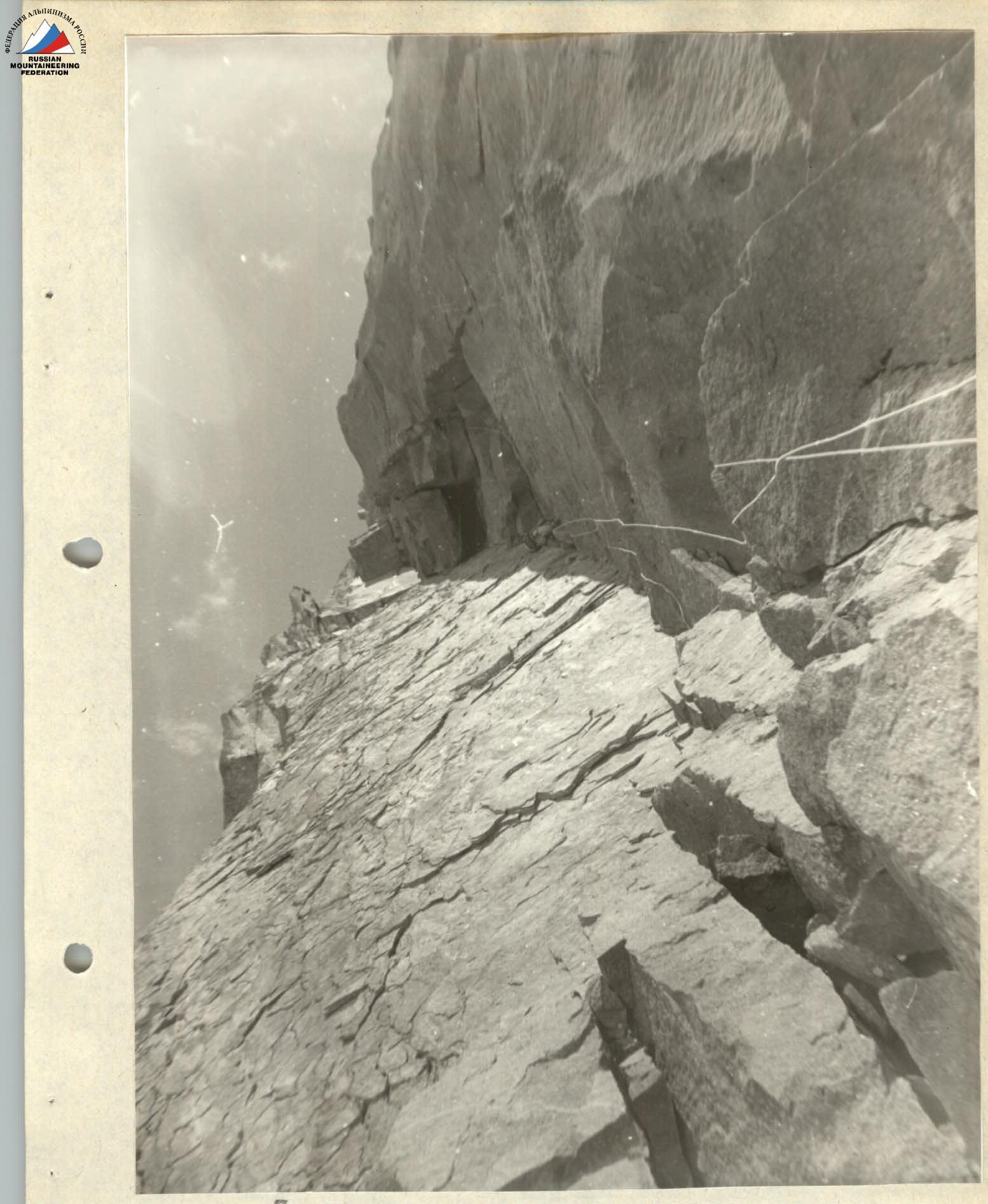
Photo 7. Ahead is a cornice, R6–R7, July 24, 1989, 14:00, lens T-43, focal length 40 mm.
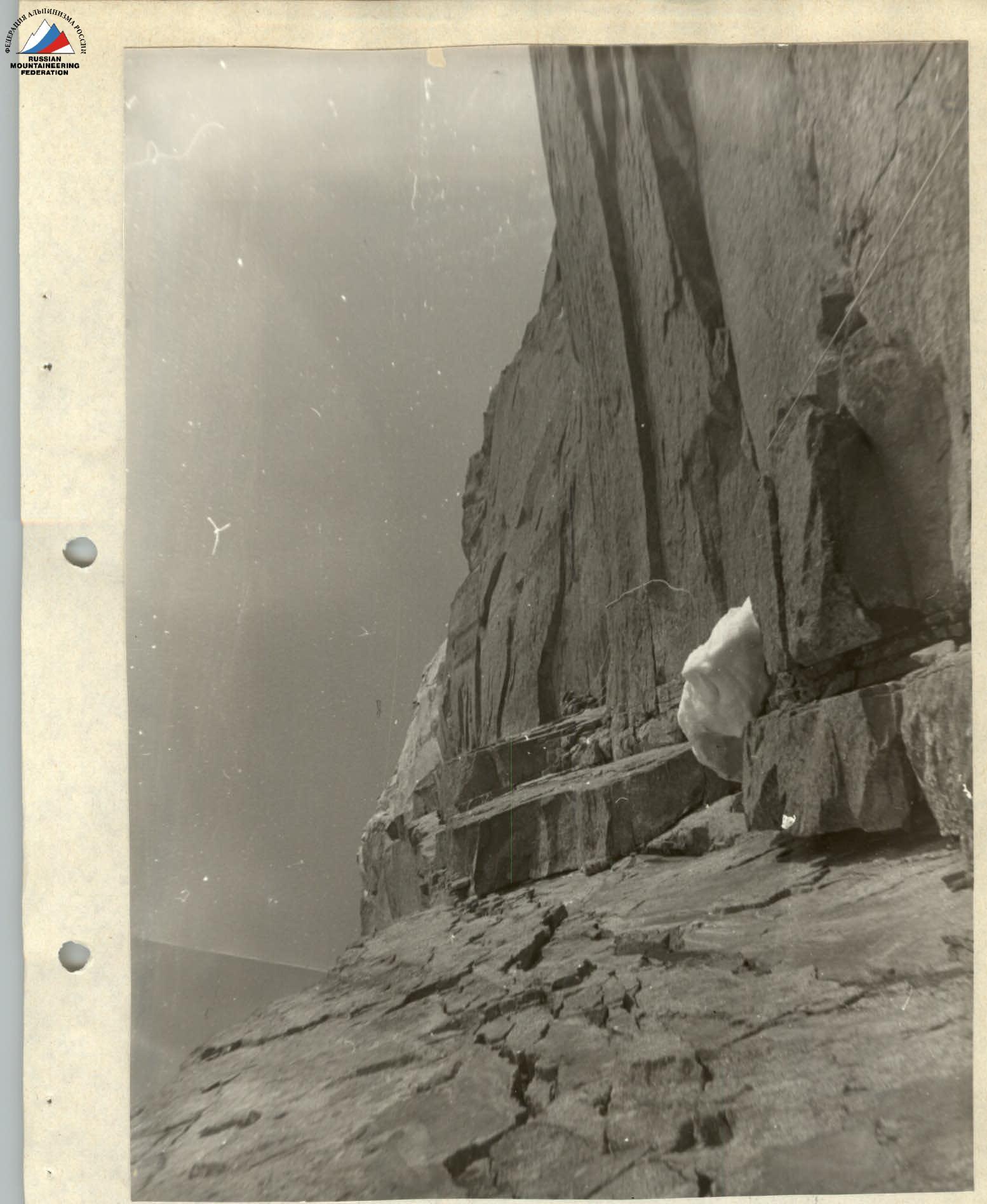
Photo 10. Along the internal corner, R13–R14, July 25, 1989, 12:00, lens T-43, focal length 40 mm.
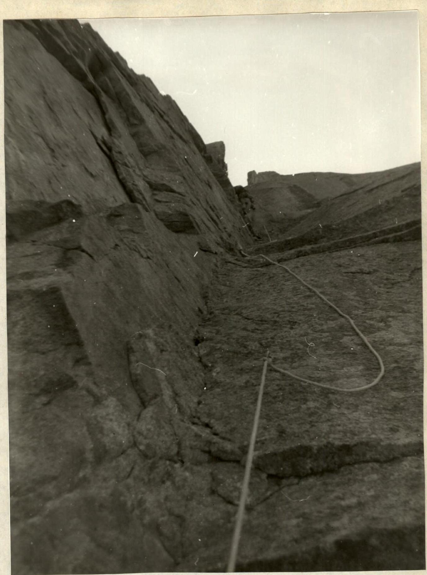
Photo 11. Through a small overhang, R16–R17, July 25, 1989, 17:00, lens T-43, focal length 40 mm.