Passport
I. Technical class.
- Pamir-Alay, Turkestan Range, Kara-Su gorge (upper reaches of the Karavshin river).
- Peak Pyramidal (5510 m) via the central counterfort of the northern wall.
- First ascent, category VI complexity (tentative).
- Route characteristics:
elevation gain: 1720 m, route length: 1985 m, length of sections: 5–6 cat. diff. — 1665 m, 4 cat. diff. — 320 m, average steepness:
- main part of the wall — 76°, 2) rest of the route — 66 — 66°.
- Number of pitons used:
| rock | chocks | ice |
|---|---|---|
| 114 | 265 | 67 |
| 28 | 41 |
- Number of travel hours: 58 h (5 days).
- Number of nights: 4
of which: semi-reclined — 1, reclined — 3.
- Team leader: Voronov A.A. — CMS/rock, MS/alp.
Bankovsky M.G. — CMS/CMS Ivanov V.N. — CMS/CMS Nabokov V.M. — 1st sports category/CMS Filkov M.B. — 1st sports category/CMS
- Team coach: Solonnikov V.A. — ICMS.
- Departure to the route — July 8, 1989.
Reached the summit — July 12, 1989 at 17:30. Returned to base camp — July 13, 1989.
- Team LOS DFSO trade unions
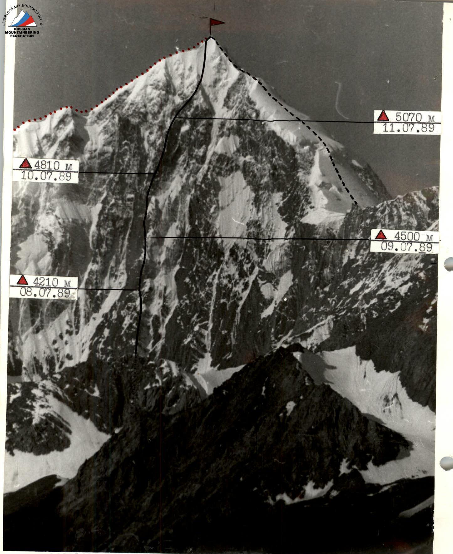
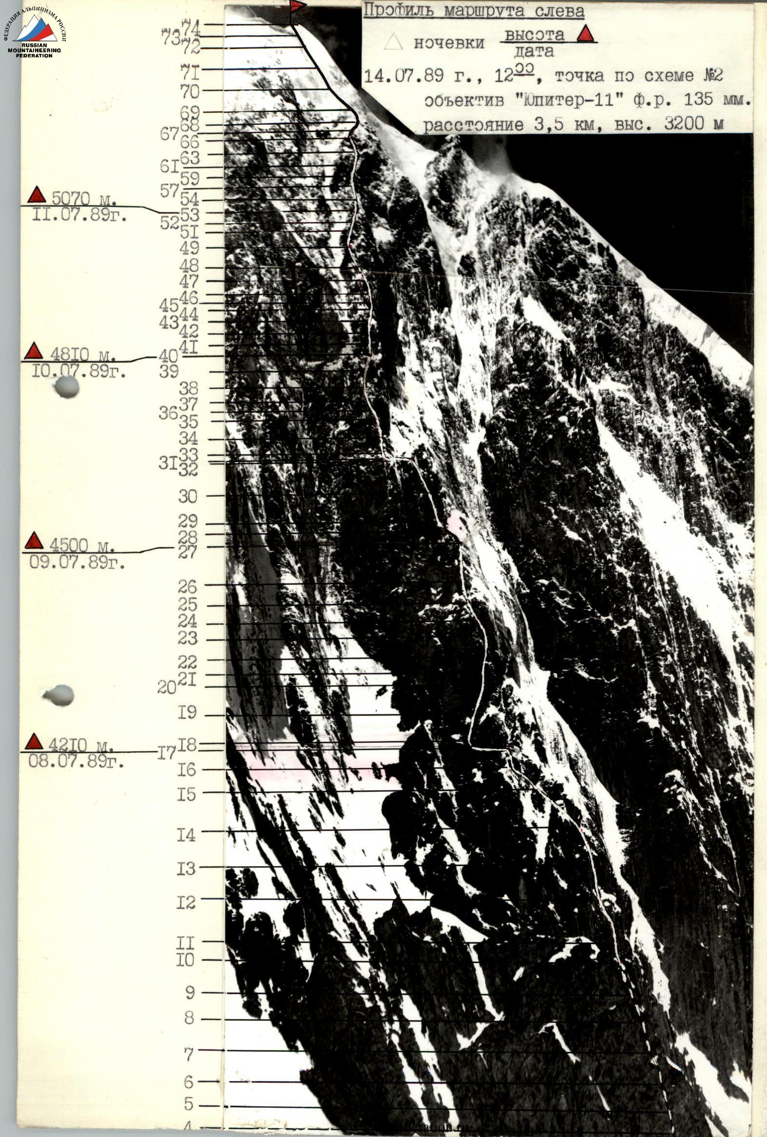
Peak Pyramidal — 5510 m. Path of team LGSC 1987 – path of team LOS DFSO trade unions 1989.
A bivouacs:
- altitude
- date July 14, 1989
- Shooting point according to scheme No. 1, distance 10 km, altitude 3500 m
- Lens "Jupiter-11" F.R. 135 mm
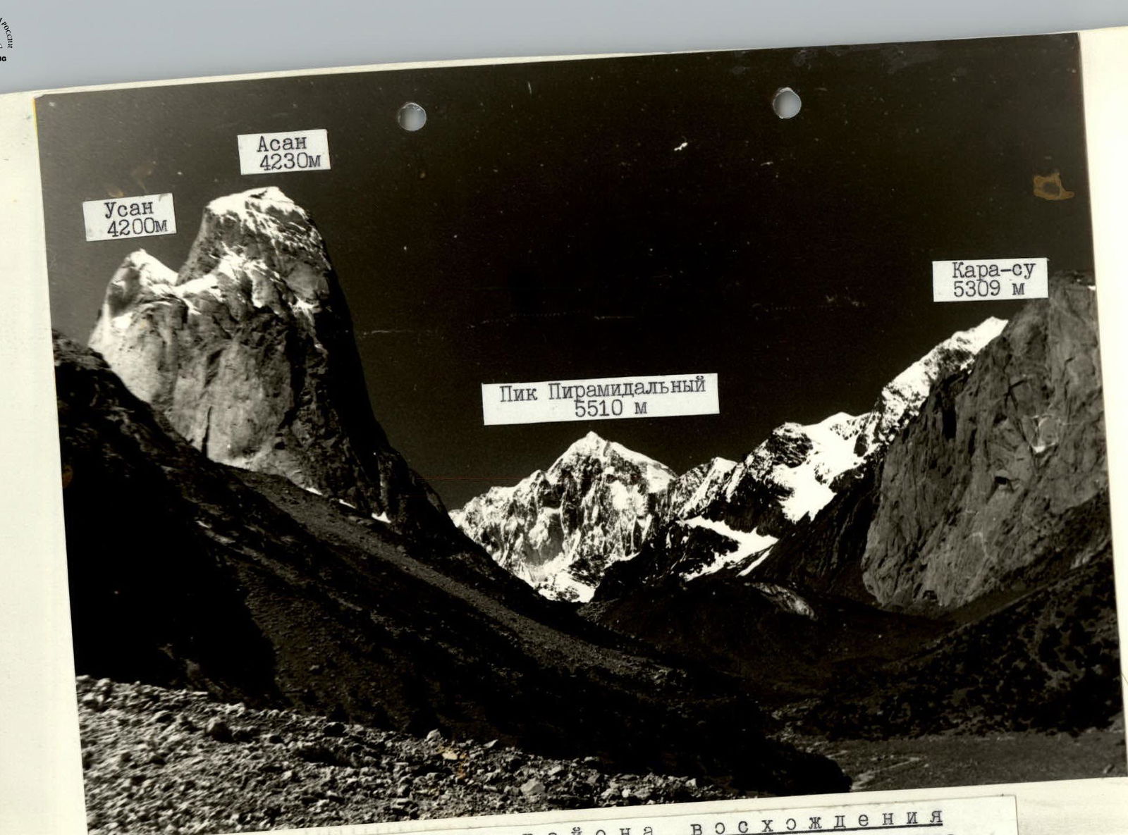
Panorama of the ascent area. Shooting point according to scheme No. 5, distance 10 km, altitude 3200 m, lens "Jupiter-12" F.R. 35 mm.
Tactical actions of the team
The team's actions on the route were determined by the developed tactical plan. It was drawn up after preliminary observations. Observations were carried out from a spur opposite the wall with a 60× telescope. From there, a passage through the icefall was also observed, which presents a certain difficulty in its passage. A detailed consultation on the descent from the summit was obtained from the participants of the ascent to Peak Pyramidal, carried out in July 1987.
There are 2–3 possible routes on the wall. We chose a route along the center of the wall with a direct exit to the summit. It is logical and safe. Based on these data, a tactical plan was drawn up, which was as follows:
- Passage through the icefall into the "circus" under the route should take place early in the morning.
- Approach to the route no later than 9:00 to avoid the possibility of stones and ice falling from the couloir to the right of the route.
- Due to the glaciation of the route, take proven snow-and-ice equipment, all participants work in crampons.
- Since the wall is not typical for this area (strong glaciation, unstable weather, low temperature) — take warm clothes on the route.
- Minimize the weight of backpacks by using lightweight personal and public equipment and high-calorie food (250–300 g per person per day), which will allow for a safer passage along the route.
- Set up a bivouac no later than 19:00 with further processing, for the most effective work in the morning (at 9:00 it's still cold for working on rock).
Two options for passing the wall were developed:
- I option: pass the route with three nights.
- II option: in case of bad weather — four nights on the route.
Taking into account the real complexity of the route (strong glaciation, unstable weather), the ascent was carried out according to the second option. On July 8, 1989, at 8:00, the team left the bivouac under the route and at 9:00 began work on the route. Each team member worked first on a double rope and without a backpack. The last one — with a lightened backpack. Movement along the ropes was carried out with top-rope protection on two jugs with klemheist nodes.
Work schedule:
| date | sections | type of movement | participants |
|---|---|---|---|
| 8.07. | R0–R14 | movement without processing | Voronov, Bankovsky |
| 9.07. | R14–R22 | movement without processing | Bankovsky, Voronov |
| R22–R24 | processing | — | |
| 10.07. | R24–R31 | movement without processing | Ivanov, Nabokov |
| R31–R33 | processing | Nabokov, Ivanov | |
| 11.07. | R33–R38 | movement without processing | Nabokov, Filkov |
| R38–R40 | processing | Ivanov, Filkov | |
| 12.07. | R40–R52 | movement without processing | Filkov, Ivanov |
Organizing overnight stays on the route for two tents is problematic, so the number of participants was limited (5 people — 1 tent).
Overnight stays were built on snow "mushrooms" and were cut out on a snow-and-ice ridge.
On July 12, 1989, at 17:30, the team reached the summit. A note from UTC LenGorsportkomitet was retrieved: "Ascent via the eastern counterfort, 5B cat. diff., second ascent". Team leader Fomin O.N. dated June 28, 1988.
Safety on the route was ensured by proper organization of movement (sheltered gathering places, belays and overnight stays, blocking of pitons, movement of participants within voice and visual communication, movement of the first on a double rope of imported production, as well as the use of quality and proven equipment).
Radio communication sessions with observers were conducted in accordance with the schedule prescribed by the head of the rescue team. The connection was constant and stable.
Thus, the second variant of the tactical plan was adopted as the main one and fully implemented.
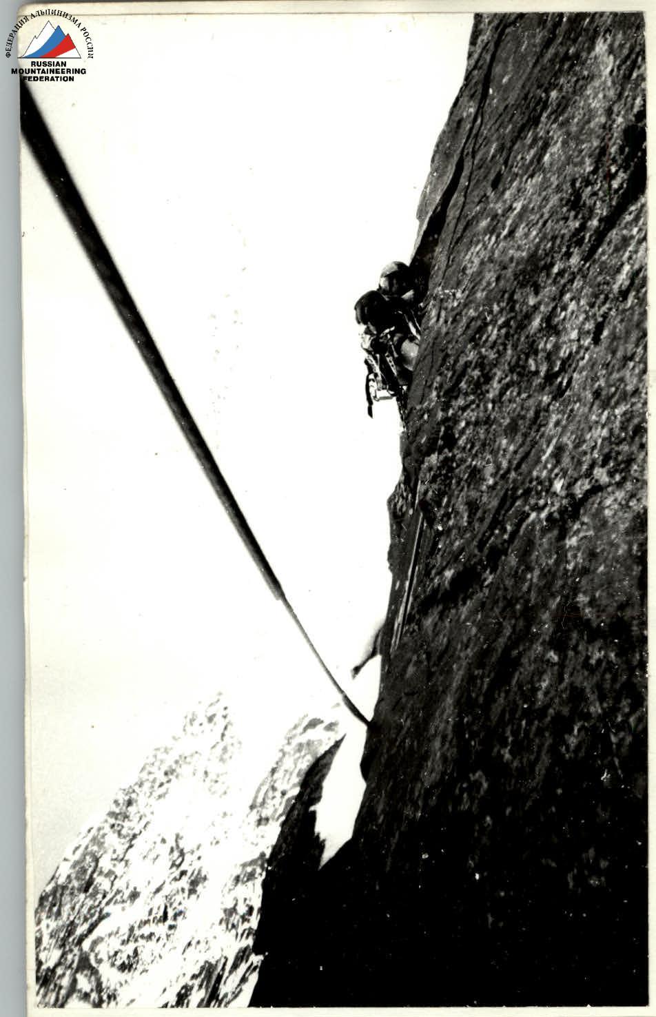
Photo No. 4. On section R23.
Photo No. 3. On section R19–R20
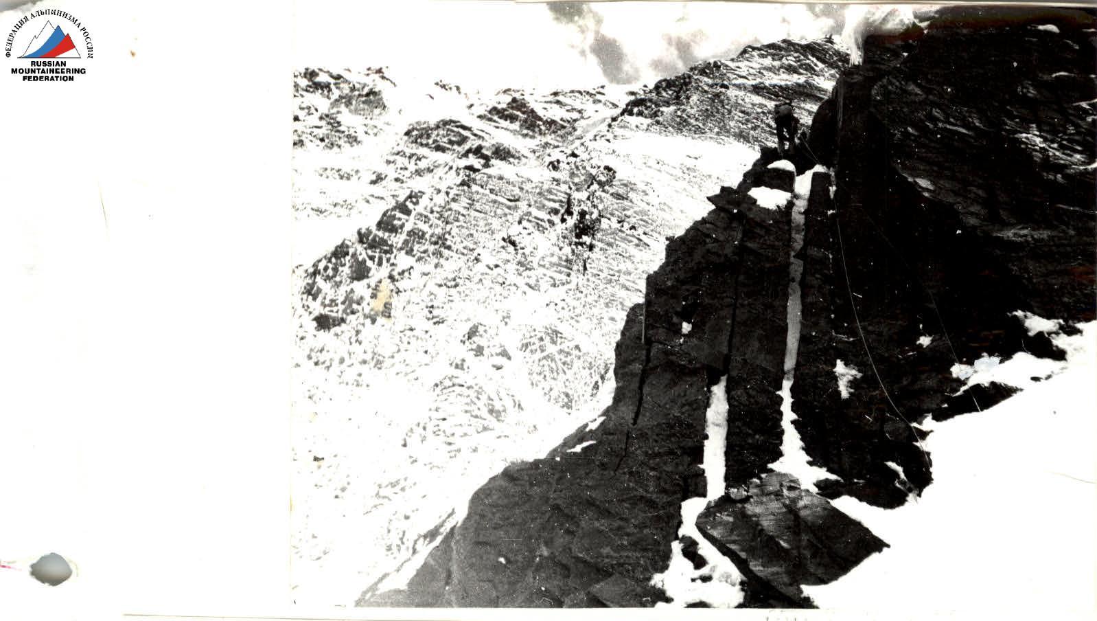
Photo No. 2. On section R13–R14
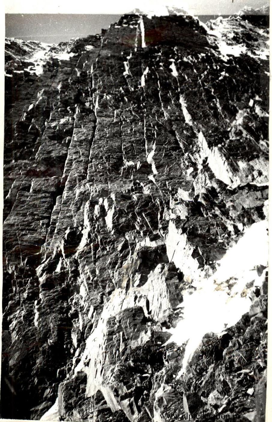
Photo No. 1. On section R1–R3
Route scheme in symbols
MB:1300 (1 cm = 13 m) in height. Traverse sections (T) are also taken according to the elevation gain.
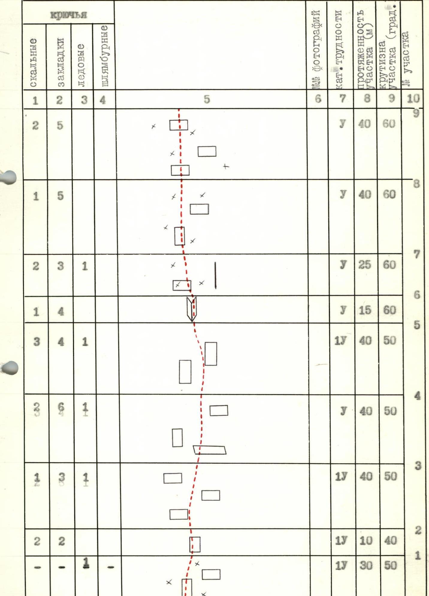
| rock | chocks | ice | screw | photo No. | cat. difficulty | length of section (m) | steepness of section (deg.) | section No. |
|---|---|---|---|---|---|---|---|---|
| 2 | 5 | complex | 40 | 60 | R8 | |||
| 1 | 5 | complex | 40 | 60 | R7 | |||
| 2 | 3 | 1 | complex | 25 | 60 | R6 | ||
| 1 | 4 | complex | 15 | 60 | R5 | |||
| 3 | 4 | 1 | extremely complex | 40 | 50 | R4 | ||
| 3 | 9 | 1 | complex | 40 | 50 | R3 | ||
| 2 | 3 | 1 | extremely complex | 40 | 50 | R2 | ||
| 2 | 2 | extremely complex | 10 | 40 | R1 | |||
| - | - | 1 | extremely complex | 30 | 50 | R0 |
540 m covered during the day, travel hours — 12.
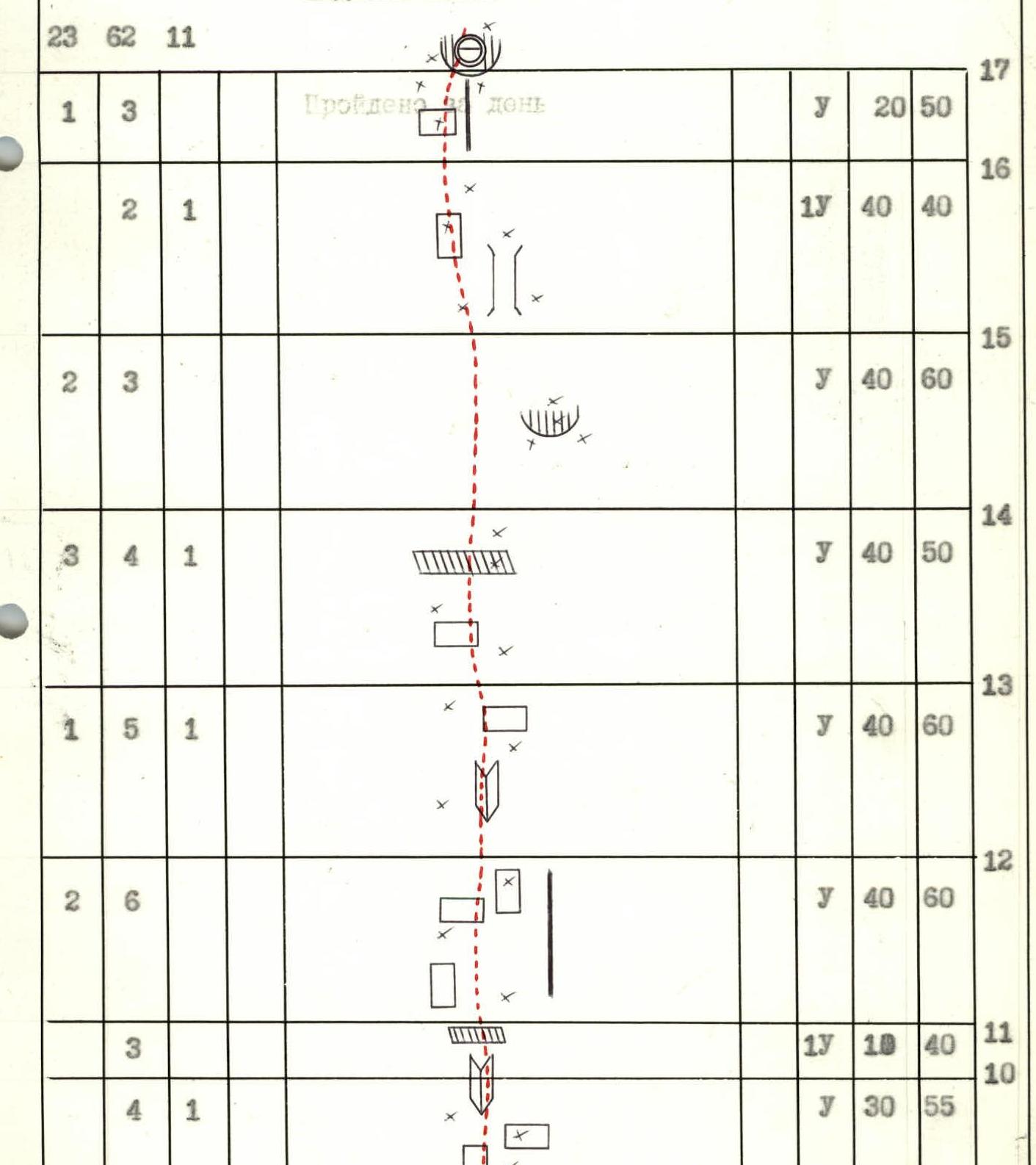
| rock | chocks | ice | screw | photo No. | cat. difficulty | length of section (m) | steepness of section (deg.) | section No. |
|---|---|---|---|---|---|---|---|---|
| 2 | 3 | 1 | complex | 20 | 70 | R29 | ||
| 3 | 4 | extremely complex | 20 | 75 | R28 | |||
| 21 | 55 | 5 | extremely complex | R27 | ||||
| 1 | 2 | extremely complex | 40 | 90 | R27 | |||
| 4 | 5 | extremely complex | 40 | 70 | R26 | |||
| 1 | 2 | complex | 20 | 80 | R25 | |||
| 2 | 4 | extremely complex | 20 | 90 | R24 | |||
| 3 | 2 | extremely complex | 40 | 90 | R23 | |||
| 3 | 5 | extremely complex | 20 | 70 | R22 | |||
| 1 | 2 | 1 | complex | 20 | 60 | R21 | ||
| 4 | 9 | extremely complex | 40 | 80 | R20 | |||
| 2 | 9 | 1 | extremely complex | 40 | 85 | R19 |
320 m processed during the day, 40 m processed outside the bivouac, travel hours — 12.
| rock | chocks | ice | screw | photo No. | cat. difficulty | length of section (m) | steepness of section (deg.) | section No. |
|---|---|---|---|---|---|---|---|---|
| 1 | 2 | extremely complex | 20 | 80 | R40 | |||
| 4 | extremely complex | 20 | 80 | R39 | ||||
| 5 | extremely complex | 40 | 80 | R38 | ||||
| 6 | extremely complex | 40 | 80 | R38 | ||||
| 7 | 4 | 1 | extremely complex | 20 | 70 | R37 | ||
| 8 | 4 | 1 | extremely complex | 20 | 70 | R37 | ||
| 9 | 4 | 1 | complex | 10 | 60 | R36 | ||
| 1 | 2 | complex | 10 | 60 | R35 | |||
| 2 | 4 | 2 | extremely complex | 30 | 80 | R34 | ||
| 4 | 8 | extremely complex | 40 | 80 | R33 | |||
| 1 | 7 | extremely complex | 10 | 80 | R33 | |||
| extremely complex | 30 | 60 | R32 | |||||
| 1 | 3 | 1 | extremely complex | 40 | 80 | R31 | ||
| 2 | extremely complex | 40 | 80 | R31 | ||||
| 3 | extremely complex | 40 | 80 | R30 | ||||
| 4 | extremely complex | 40 | 80 | R30 | ||||
| 5 | extremely complex | R30 |
40 m processed during the day, 300 m without processing, 70 m processed outside the bivouac, travel 12 h 30 min.
| rock | chocks | ice | screw | photo No. | cat. difficulty | length of section (m) | steepness of section (deg.) | section No. |
|---|---|---|---|---|---|---|---|---|
| 1 | 2 | - | - | complex | 5 | 65 | R55 | |
| - | 2 | - | - | extremely complex | 10 | 70 | R54 | |
| 28 | 51 | 7 | extremely complex | R54 | ||||
| 2 | 5 | - | - | complex | 30 | 60 | R54 | |
| 3 | 3 | 2 | - | extremely complex | 30 | 65 | R53 | |
| 1 | 2 | - | - | extremely complex | 10 | 80 | R52 | |
| - | 3 | - | - | extremely complex | 10 | 100 | R51 | |
| 1 | 3 | 2 | - | complex | 20 | 70 | R50 | |
| 4 | 3 | - | - | complex | 20 | 65 | R49 | |
| 4 | - | - | extremely complex | 20 | 75 | R48 | ||
| 4 | - | - | extremely complex | 40 | 90 | R47 | ||
| 2 | 1 | - | - | complex | 10 | 70 | R46 | |
| 2 | 2 | - | - | complex | 10 | 65 | R45 | |
| 2 | 2 | - | extremely complex | 20 | 70 | R44 | ||
| 2 | 2 | - | extremely complex | 40 | 70 | R43 | ||
| 2 | 1 | complex | 10 | 60 | R42 | |||
| 1 | 2 | - | - | extremely complex | 20 | 70 | R41 | |
| 2 | 2 | - | - | extremely complex | 20 | 70 | R40 |
290 m covered during the day, 70 m processed, 55 m processed above the bivouac, travel 12 h.
| rock | chocks | ice | screw | photo No. | cat. difficulty | length of section (m) | steepness of section (deg.) | section No. |
|---|---|---|---|---|---|---|---|---|
| 4 | complex | 40 | 50 | R69 | ||||
| 1 | 1 | 2 | extremely complex | 40 | 40 | R68 | ||
| 2 | 1 | 2 | extremely complex | 40 | 40 | R66 | ||
| 2 | 3 | extremely complex | 40 | 40 | R65 | |||
| 1 | 4 | 1 | complex | 10 | 65 | R64 | ||
| 2 | 2 | 1 | extremely complex | 30 | 65 | R63 | ||
| 1 | 3 | extremely complex | 10 | 70 | R62 | |||
| 2 | 3 | 3 | extremely complex | 30 | 65 | R61 | ||
| 2 | 2 | 4 | extremely complex | 10 | 65 | R60 | ||
| 1 | 2 | complex | 10 | 70 | R58 | |||
| 1 | 2 | complex | 15 | 65 | R57 | |||
| complex | 15 | 70 | R56 |
55 m processed during the day, 470 m not processed, travel 9 h 30 min.
| rock | chocks | ice | screw | photo No. | cat. difficulty | length of section (m) | steepness of section (deg.) | section No. |
|---|---|---|---|---|---|---|---|---|
| 114 | 265 | 67 | - | |||||
| 28 | 41 |
2015 m covered on the route in total, total travel hours 58, travel days 5.
The route starts on the left side of the middle snow-and-ice cone. R0–R1 Bergschrund is crossed in the upper part of the cone on its left side, then 30 m along the snow-and-ice slope — partially snow-covered rocks. Protection via ice screws, movement in crampons. R1–R2 Along firm firn under a rocky wall with icy streaks. Protection via ice screw and rock pitons. Movement in crampons. R2–R3 Up snow-covered rocky slabs. Ice in cracks, местами ledyные натёки. Protection via rock and ice pitons. Movement in crampons. R3–R4 Climbing becomes more complicated. Along rocky slabs with ice to the inner corner and through it. Movement in crampons. R4–R5 Further 40 m along rocky slabs, местами snow-covered, to a vertical angle. Movement in crampons, protection via rock and ice pitons and chocks. R5–R6 Along the vertical angle — exit to the ridge of the counterfort. Climbing is complex. R6–R7 To the right of the rocky wall up along the snow-and-ice ridge. Movement in crampons. R7–R8 Further along the ridge 40 m under a rocky wall. Complex climbing in crampons along snow-covered rocks. R8–R9 The clear ridge of the counterfort disappears. Movement 40 m along complex smoothed slabs covered with snow, местами ice. R9–R10 Rocky slabs lead to an inner corner filled with ice. At the beginning of the corner, protection via ice screw. Climbing is complex. R10–R11 The inner corner leads to a gentle slab. R11–R12 Through complex rocky slabs — 40 m in the direction of the inner corner. Climbing is complex. Protection via pitons and chocks. R12–R13 Through the inner corner under a steep wall with powerful ice formation in the lower part. Here, protection via ice screw, далее — rock pitons and chocks. Climbing is complex. R13–R14 40 m along snow-covered and icy rocks in the direction of a cornice. R14–R15 The snow cornice is bypassed on the left along rocks. Climbing is complex. R15–R16 Left and up along the left side of the couloir along simple, gentle rocks in the direction of a snow "mushroom". R16–R17 Through a rocky wall filled with ice — exit on the left side to the "mushroom". Here, on the snow "mushroom" — overnight stay. The entire path to the overnight stay was covered in crampons, as icy and snow-covered rocks do not allow working without crampons. R17–R18 Traverse left and down, then up through the couloir under the base of a rocky bastion. Rocks are heavily destroyed. Organization of protection when passing through the couloir is complex. Movement in crampons. R18–R23 The bastion is passed along steep inner corners and slabs on its right side. Climbing is extremely complex. Crampons need to be removed. Ladder is used. R23–R24 Steep wall — 20 m, monolith. Passed in the lower part on artificial aids (ITo), далее — climbing to the right and up to the inner corner. Climbing is extremely complex. R24–R25 The inner corner throws to the left. Movement along small cracks on the left side of the corner. R25–R27 Along heavily snow-covered and icy steep destroyed slabs in the direction of a snow "mushroom". Climbing is extremely complex in crampons, ITo. Approach to the "mushroom" from the left. Overnight stay on the "mushroom". R27–R30 Destroyed icy rocks. Climbing is extremely complex, ITo. Movement in the direction of the ridge. R30–R31 Movement along the left side of the ridge. Rocks are in ice, ITo. Climbing is extremely complex. R31–R32 Traverse through the couloir to the left. In the couloir, rocks are covered with ice. Protection via ice screw. R32–R33 After the traverse — a 10-meter steep wall. On it — a belay point. Climbing is extremely complex. R33–R34 Along rocky steep slabs to the left of the "nose" — to the inner corner. Climbing is extremely complex. Movement in crampons. R34–R35 Movement along the left side of the steep ice chimney. R35–R36 Transition to the left along less steep slabs to the left side of a clearly defined ridge. R36–R38 Along icy, steep, heavily destroyed rocks on the left side of the ridge — 40 m. Movement in crampons. R38–R39 40 m through heavily destroyed steep rocks with an inner corner in the upper part. Climbing is extremely complex, местами ITo. R39–R40 To the right and up to a snow drift. Here, an overnight stay is organized. R40–R42 From the overnight stay — 20 m along steep destroyed rocks up and 10 m to the right and up. Be careful — loose rocks. Climbing is extremely complex. R42–R43 Movement along a snow-covered icy rocky ridge. Steep rocky slabs. Climbing is extremely complex. Movement in crampons. R43–R44 Steep ice couloir. Protection on ice and rocks. R44–R45 From the couloir to the left and up along heavily destroyed rocks. R45–R46 Destroyed rocks, схваченные льдом. Organization of protection is complex. Movement in crampons. R46–R47 40 m up along steep destroyed rocks. Climbing is extremely complex. местами ITo. R47–R49 Along the left side of the rib, along destroyed rocks. 20 m — extremely complex climbing, further — complex climbing, местами ITo. R49–R50 Destroyed rocks, залитые льдом, lead under an overhanging rocky wall. R50–R51 Through the overhanging wall "head-on". Climbing is extremely complex. R51–R52 A steep slab is passed by climbing. Climbing is very complex. R52–R54 Heavily snow-covered, icy rocks lead to a ridge covered with dense snow. Here — overnight stay. R54–R56 Through a couloir filled with ice and a snow-and-ice wall in its upper part — under the base of a 15-meter rocky wall. Climbing is extremely complex and complex, movement in crampons. R56–R57 Through the wall, залитую льдом, — transition to the left side of the ridge. R57–R59 Along the couloir on the left side of the ridge — to a small saddle, where the counterfort turns into a summit tower. Rocks are heavily destroyed, many "loose" rocks. Organization of protection is complex. Movement in crampons. R59–R60 The exit to the summit tower begins along an icy wall leading to an ice-and-rock couloir. Movement in crampons. R60–R61 30 m along a steep ice-and-rock couloir. Here — a convenient protected belay point. Loose rocks. Climbing is extremely complex. R61–R63 The next 30 m of the ice-and-rock couloir lead to a 10-meter wall, which is overcome to the left and up. R63–R64 Steep inner corner, местами ice. Climbing is extremely complex. R64–R65 A 10-meter destroyed, icy wall leads to a snow-covered rocky rib. R65–R68 A snow-covered rocky rib leads under the base of an ice wall. R68–R73 An ice wall with increasing steepness in its upper part leads under a snow dome of the summit. R73–R74 Along a gentle snow slope — ascent to the summit.
Footnotes
-
5070 m. July 11, 1989 R52–R53, R46, R48, R47, R46, R46, R43–R44, R41–R42, R41. July 9, 1989 R39, R38, R38–R35, R34, R31–R33, R30, R29, R25–R27, R26, R25, R24, R23, R22, R20–R21, R19. July 8, 1989 R17–R18, R16, R15, R14, R13, R12, R11, R10, R9, R8, R7, R6, R5. ↩