-
Climbing category — altitude-technical.
-
Climbing area — Pamir-Alay, Turkestan Range, Kara-su river gorge (tributary of Karavshin river).
-
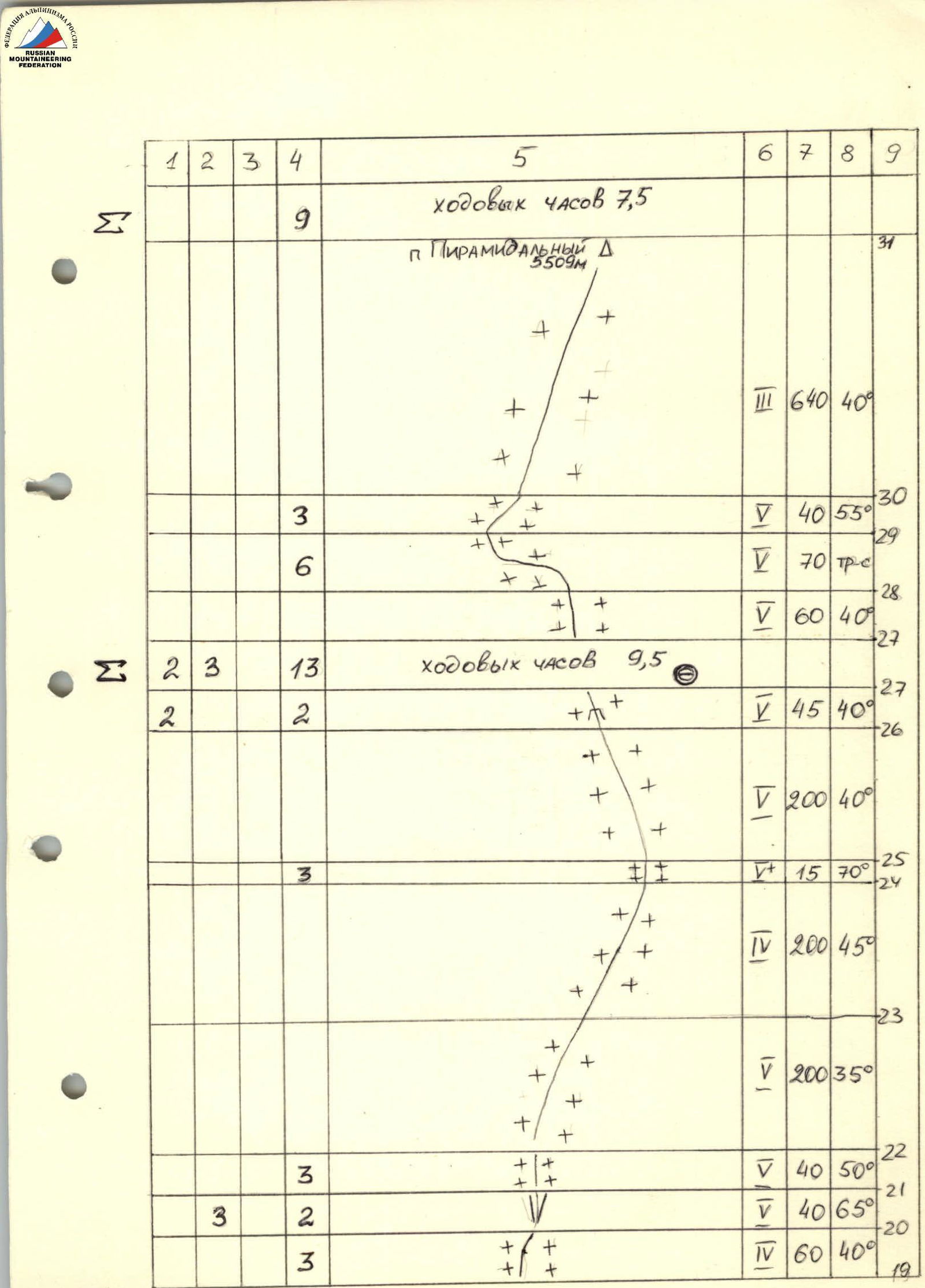
Object of ascent — Pyramid Peak, 5509 m, via the eastern spur, combined route.
-
Proposed — 5B category of difficulty, first ascent.
-
Height difference — 1890 m, route length — 2520 m, including 5–6 category of difficulty — 1350 m, average steepness — 49°.
-
Pitons driven
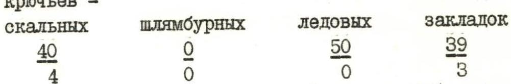
| Rock | Bolt | Ice | Nuts |
|---|---|---|---|
| 40 | 0 | 50 | 39 |
| 4 | 0 | 0 | 3 |
-
Team's travel hours — 36.5, days — 5 (including 1 day waiting for good weather).
-
Overnights on the route — 4, bivouac.
-
Team leader — Oleg V. Nazarov, Master of Sports
Team members:
- Vyacheslav S. Marchenko, Candidate for Master of Sports
- Igor V. Kirillovskiy, Candidate for Master of Sports
- Gennadiy V. Makarov, Candidate for Master of Sports
- Mikhail Yu. Filkov, Candidate for Master of Sports
- Dmitry A. Usevich, 1st sports category
-
Team coach — Alexey D. Pugachev.
-
Departure to the route July 4, 1987, to the summit July 8, 1987, return July 9, 1987.
-
Organization — LOS DFSO Trade Unions "Trud", Leningrad.
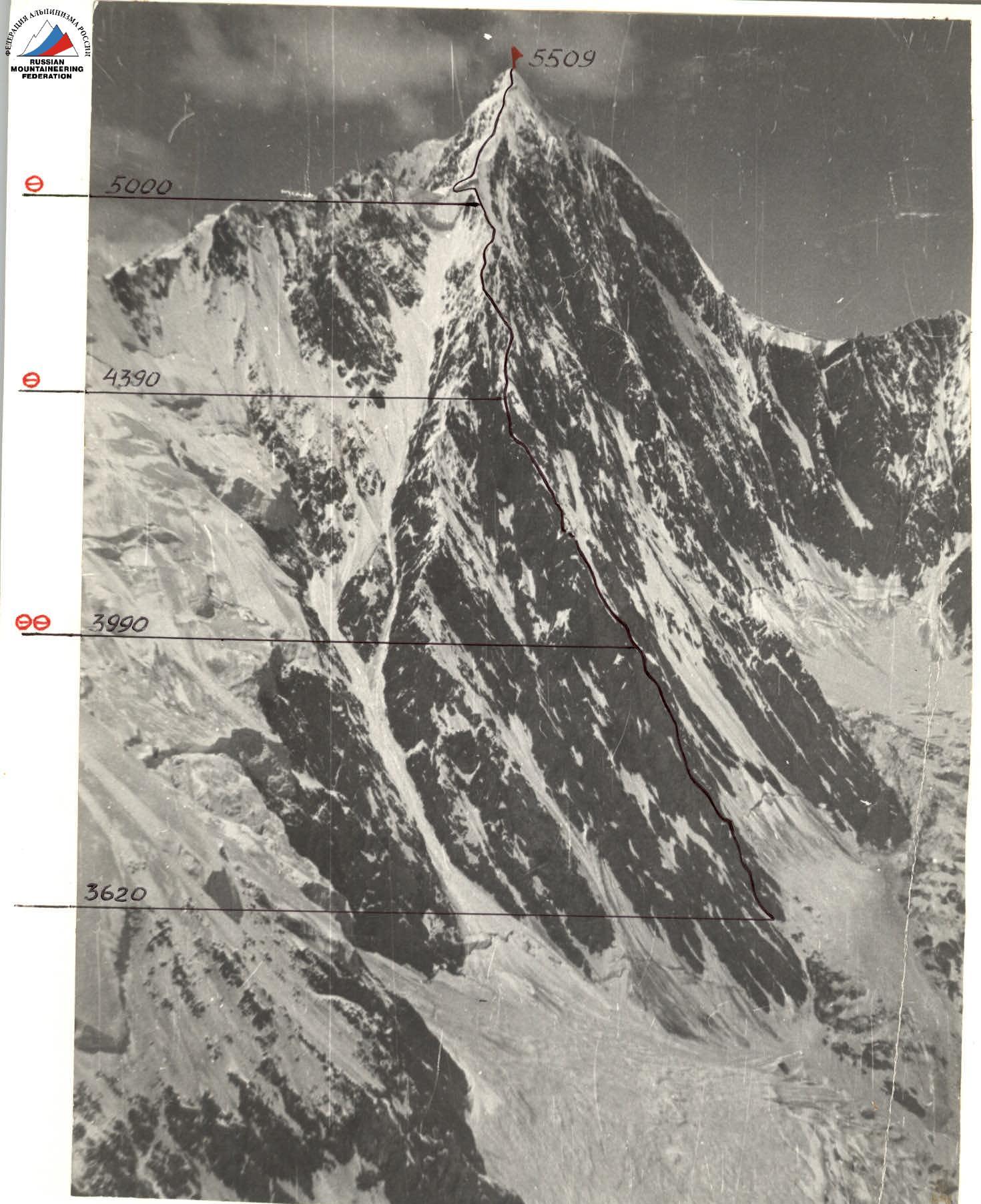 F. No. 1. Pyramid Peak, 5509 m. Photo taken on June 30, 1987, 13:00, lens T-34, focal length 4 cm, distance 4 km, shooting point No. 1, height 3600 m.
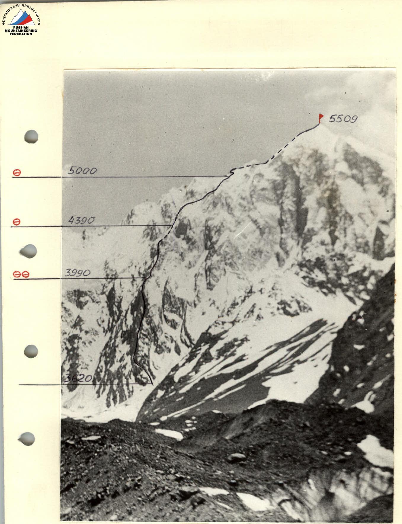 F. No. 2. Route profile from the right. Photo taken on June 30, 1987, 7:00, lens T-34, focal length 4 cm, distance 7 km, shooting point No. 2, height 3200 m.
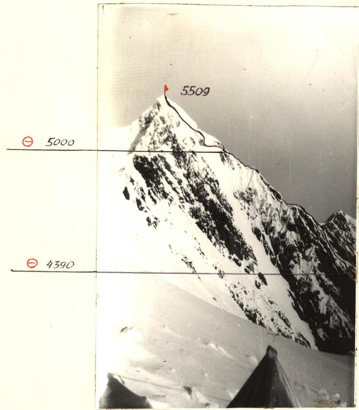 F. No. 3. Route profile from the left. Photo taken on July 1, 1987, 8:00, lens T-34, focal length 4 cm, distance 3 km, shooting point No. 3, height 4500 m.
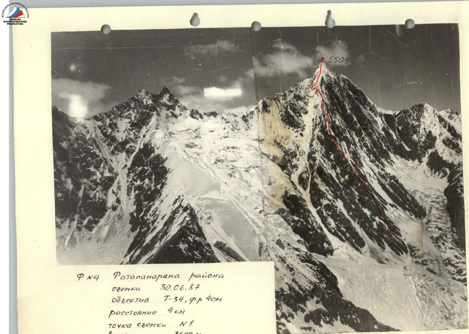 F. No. 4. Panoramic photo of the area. Photo taken on June 30, 1987, lens T-34, focal length 4 cm, distance 4 km, shooting point No. 1, height 3600 m.
Tactical actions of the team
The tactical plan during the ascent included:
- bypassing the lower rocky section of the spur on the right along the snowy slope, then exiting to the rocks of the spur with subsequent movement along the left side of the spur to the rocky bastion;
- passing the middle part of the spur first along the snow-ice slope, bypassing three "gendarmes" on the right into a small failure of the spur after the third "gendarme", from which snow cornices hang. Then approaching and overcoming the rocks, leading to the snowy ridge of the spur;
- overcoming the ice cornices at an altitude of 5100 m along the passage on their left side with further exit to the main ridge.
In addition, as a result of observations, the following was found out:
- the safety of passing ice cornices and snow-ice slopes can be ensured due to early passage;
- the slopes of the spur are illuminated at 8:00 am;
- organization of overnight stays is possible almost along the entire length of the spur.
These considerations were taken into account when developing the tactical plan as follows:
- the number of participants on the route — 6 people;
- passing the ice cornice in the upper part of the spur is carried out from overnight stays as close as possible to the passage;
- passing the rocky belt in the middle part of the spur during one travel day;
- a reserve day was planned for bad weather.
The route by travel days and sections was generally passed in accordance with the tactical plan. On the second day — July 5, 1987 — movement along the route was not carried out due to bad weather, the overnight stay remained in the same place, as provided by the tactical plan option.
The lead rope team changed, as a rule, every 5–7 ropes. Preliminary processing of route sections was not carried out. On sections of 1–7 categories of difficulty (partially), the group's movement was carried out along a fixed rope (perils), on the remaining sections, alternate or simultaneous (depending on the terrain) movement of the rope teams was carried out along the left pitons.
Team's movement schedule:
- July 4, 1987: Approach from the base camp, exit to the route at 11:00. Exit to the rocky bastion at 16:15, stopped for the night at 19:30.
- July 5, 1987: Heavy bad weather throughout the day, no movement, overnight stay in the same place.
- July 6, 1987: Movement from 8:00 to 19:00 — passage of the rocky belt of the middle part of the spur. 19:00 — arrangement of a bivouac on a snowy ledge of a rocky outcrop.
- July 7, 1987: Movement from 8:30 to 10:30 — exit to the snowy ridge of the spur. Until 18:00 — passage of the snow-ice ridge. 18:00 — organization of a bivouac on the ridge.
- July 8, 1987: Movement from 8:00 to 10:00 — approach and overcoming the ice cornice with exit to the main ridge. 15:30 — exit to the summit. 16:00–18:00 — descent along the snow-ice ridge-slope towards Zap. Vadif Pass.
- July 9, 1987: Continuation of descent to the base camp — 8:30–18:00.
The organization of overnight stays was carried out on ridges and snow-ice slopes by cutting ice and clearing snow.
Safety measures:
- piton belay and belay using nuts on the entire route, blocking pitons on perils;
- organization of perils on sections of 1–7 categories of difficulty;
- organization of overnight stays in safe places;
- reducing the distance between intermediate pitons on rocky areas covered with snow;
- use of imported rope with good dynamic characteristics;
- exact implementation of the planned ascent plan.
There were no falls, injuries, or illnesses during the passage of the route. Fundamentally new equipment samples were not used. Unstable weather prevailed on the days of the ascent. On July 5, 1987, heavy snowfall occurred throughout the day, and movement along the route was not carried out. On July 7 and 8, starting from 16:00 or 17:00, it snowed. Abundant fresh snowfall made it difficult to move along the main ridge of the peak and the ridge of the spur, which was a series of "gendarmes" with hanging snow caps connected by narrow ridges, which required participants to be accurate in their passage and careful belaying when overcoming it.
Regular and stable radio communication was maintained with the base camp using the "Lastochka" VHF radio station.
Route diagram
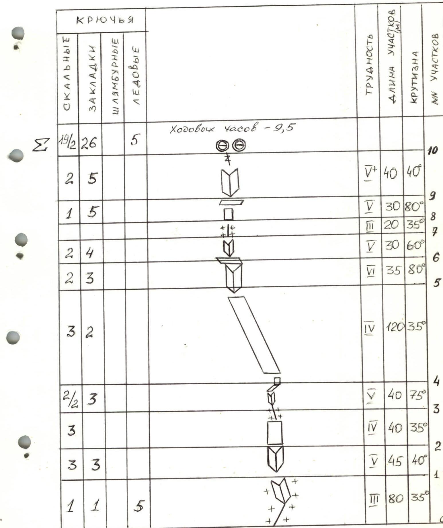
Route passport (technical data by sections)
Travel hours — 9.5
| Section No. | Rock | Nuts | Bolt | Ice | Category of difficulty | Length, m | Steepness, ° | Notes |
|---|---|---|---|---|---|---|---|---|
| R10 | 2 | 5 | 0 | 0 | 5 | 40 | 40 | |
| R9 | 1 | 5 | 0 | 0 | 5 | 30 | 80 | |
| R8 | 2 | 4 | 0 | 0 | 3 | 20 | 35 | |
| R7 | 2 | 3 | 0 | 0 | 4 | 30 | 60 | |
| R6 | 0 | 0 | 0 | 0 | 6 | 35 | 80 | |
| R5 | 3 | 2 | 0 | 0 | 4 | 120 | 35 | |
| R4 | 2/2 | 3 | 0 | 0 | 4 | 40 | 75 | |
| R3 | 3 | 0 | 0 | 0 | 4 | 40 | 35 | |
| R2 | 3 | 3 | 0 | 0 | 5 | 45 | 40 | |
| R1 | 1 | 1 | 0 | 5 | 3 | 80 | 35 | |
| R0 |
Travel hours — 11
| Section No. | Rock | Nuts | Bolt | Ice | Category of difficulty | Length, m | Steepness, ° | Notes |
|---|---|---|---|---|---|---|---|---|
| R19 | 3 | 0 | 0 | 0 | 5 | 60 | 45 | |
| R18 | 4/1 | 9/2 | 0 | 0 | 5 | 40 | 70 | |
| R17 | 7 | 0 | 0 | 0 | 4 | 160 | 35–40 | |
| R16 | 0 | 0 0 | 0 | 5 | 60 | 40 | ||
| R15 | 4/1 | 1/1 | 0 | 0 | 6 | 25 | 80 | |
| R14 | 1 | 0 | 0 | 3 | 5 | 15 | 60 | |
| R13 | 0 | 0 | 0 | 8 | 5 | 100 | – | |
| R12 | 0 | 0 | 0 | 12 | 5 | 120 | 50 | |
| R11 | 0 | 0 | 0 | 0 | 5 | 40 | 35 |
Travel hours — 9.5
| Section No. | Rock | Nuts | Bolt | Ice | Category of difficulty | Length, m | Steepness, ° | Notes |
|---|---|---|---|---|---|---|---|---|
| R31 | 0 | 0 | 0 | 9 | 3 | 640 | 40 | |
| R30 | 0 | 0 | 0 | 3 | 5 | 40 | 55 | |
| R29 | 0 | 0 | 0 | 6 | 5 | 70 | – | Traverse |
| R28 | 0 | 0 | 0 | 0 | 5 | 60 | 40 | |
| R27 | 2 | 3 | 0 | 0 | 5 | 45 | 40 | |
| R26 | 0 | 0 | 0 | 2 | 5 | 200 | 40 | |
| R25 | 0 | 0 | 0 | 3 | 5 | 15 | 70 | |
| R24 | 0 | 0 | 0 | 0 | 4 | 200 | 45 | |
| R23 | 0 | 0 | 0 | 0 | 5 | 200 | 35 | |
| R22 | 0 | 0 | 0 | 3 | 5 | 40 | 50 | |
| R21 | 0 | 0 | 0 | 2 | 5 | 40 | 65 | |
| R20 | 0 | 0 | 0 | 3 | 4 | 60 | 40 |
Route description by sections
| Section No. | Passage of the section | Group's movement |
|---|---|---|
| R0–R1 | From the glacier along the snowy couloir to the right of the spur. Traverse left-up to the rocks of the spur. | in ropes simultaneously |
| R1–R2 | Exit to the ridge along the inner corner, composed of large monolithic blocks. Climbing on underclings. | along perils |
| R2–R3 | Not clearly expressed couloir with a wall in the middle part, leading to a snowy ridge. | simultaneously, alternately |
| R3–R4 | Vertical inner corner, rocks in snow, then traverse right along the shelf and ascent along the vertical slab with a crack. Tense climbing. | along perils |
| R4–R5 | Along the inclined main shelf, approach to the inner corner. | simultaneously, alternately |
| R5–R6 | Monolithic steep inner corner with exit to the shelf. Difficult free climbing, cracks for thin pitons and nuts. | along perils |
| R6–R7 | Short traverse along the shelf, ascent along the inner corner with overhanging blocks. | along perils |
| R7–R8 | Rocky ridge, covered with snow, leads to the shelf. | along perils |
| R8–R9 | Steep slab with a crack. Complex free climbing. Then traverse along a narrow smooth shelf. | along perils |
| R9–R10 | Inner corner, leading to a smoothed forehead with a narrow crack. Along the inner corner, exit to the snowy ridge (overnight stay). Rocks are wet, few holds, "accurate" climbing. | along perils |
| R10–R11 | Exit along the snow to the ridge of the spur to the overnight stay site. | along perils |
| R11–R12 | Along the ice slope with a steepness of 50° upwards 150 m, bypassing 2 rocky outcrops on the right. Ice is hard, covered with freshly fallen snow up to 30 cm thick, which greatly complicates movement. | alternately |
| R12–R13 | Traverse 80–90 m along the slope with a steepness of 50°, under the 3rd "gendarme" (from the overnight stay) approach to the couloir. | simultaneously, alternately |
| R13–R14 | Along the ice couloir, exit to the failure of the spur. Ice is steep, hard, with rocky outcrops. In the couloir, there is a wind flow, streams of fresh snow. | along perils |
| R14–R15 | From the failure through a system of overhanging blocks, exit to the rocky wall. Rocks are steep, smoothed, flooded with water. The implicit inner corner is covered with ice crust. Tense climbing using ITO. | along perils |
| R15–R16 | Along the steep snowy slope-couloir, exit to the snowy ridge. Snow is loose, shallow, with rocky outcrops under the snow. | along perils |
| R16–R17 | Movement along the system of rocky slabs-shelves, covered with snow, with a small wall in the middle of the section. Cracks are filled with ice, problems with belay organization. | along perils |
| R17–R18 | Short traverse left-down under the steep inner corner with an overhanging right face. Difficult climbing along the corner under the cornice in its upper part. Passage of the cornice using ITO, traverse through the edge of the right face of the corner and exit to the snowy couloir. | along perils |
| R18–R19 | Crossing the snowy couloir with exit under the rocks of the spur. Difficult climbing along the inner corner and system of shelves, exit to the snowy ridge to the overnight stay site. | along perils |
| R19–R20 | Movement along the snow-ice slope and snowy ridge to the base of the ice cornice. | alternately, simultaneously |
| R20–R21 | Movement upwards along the ice couloir with rocky outcrops. Ice is hard, covered with 10–15 cm of snow. | alternately |
| R21–R22 | Snowy slope with a steepness of 50°. Deep loose snow, "floats" underfoot. | along perils |
| R22–R23 | Along the snowy slope, exit to the ridge of the spur. | alternately |
| R23–R24 | Snowy ridge 200 m, steepness 35°, is a series of "gendarmes" with snowy "mushrooms" connected by sharp ridges. Snow is loose, loose. | alternately |
| R24–R25 | Snow-ice ridge 200 m, 45°. The ridge ends with a snow-ice wall with a steepness of 65°, snow structure like calgarsporn. | alternately |
| R25–R26 | The ridge of the spur makes a turn to the left along the way, the average steepness is 40°. 2 "gendarmes" present a difficulty for passage, forming walls of 8–10 m, calgarsporn. | simultaneously, alternately |
| R26–R27 | Along the snow-ice slope, exit to the ridge, suitable for the cornices of the main ridge of the peak. Overnight stay on the ridge. | simultaneously |
| R27–R28 | Movement along the snowy ridge to the cornices. Traverse of the ice slope with a steepness of 55° under the cornice. | simultaneously |
| R29–R30 | Movement upwards along the ice slope to the left of the cornices, 55°, exit to the main ridge. | along perils |
| R30–R31 | Movement along the main ridge, which is a wide snow-ice slope with a steepness of 40° with 4 ascents, the difficulty is the abundance of fresh snow. Along the ridge — exit to the summit. | simultaneously |