Passport
-
Technical category
-
Northern spurs of the Turkestan Range, Karavshin gorge
-
Peak 4810 via the center of the Northwest wall (Rusyaev's route)
-
6B category difficulty
-
Height difference: 1160 m, length: 1568 m
Length of sections with 5–6 category difficulty — 1218 m, average steepness of the route — 67°, average steepness of the main part of the route — 74°.
-
Pitons used:
| Rock | Bolt | Nuts |
|---|---|---|
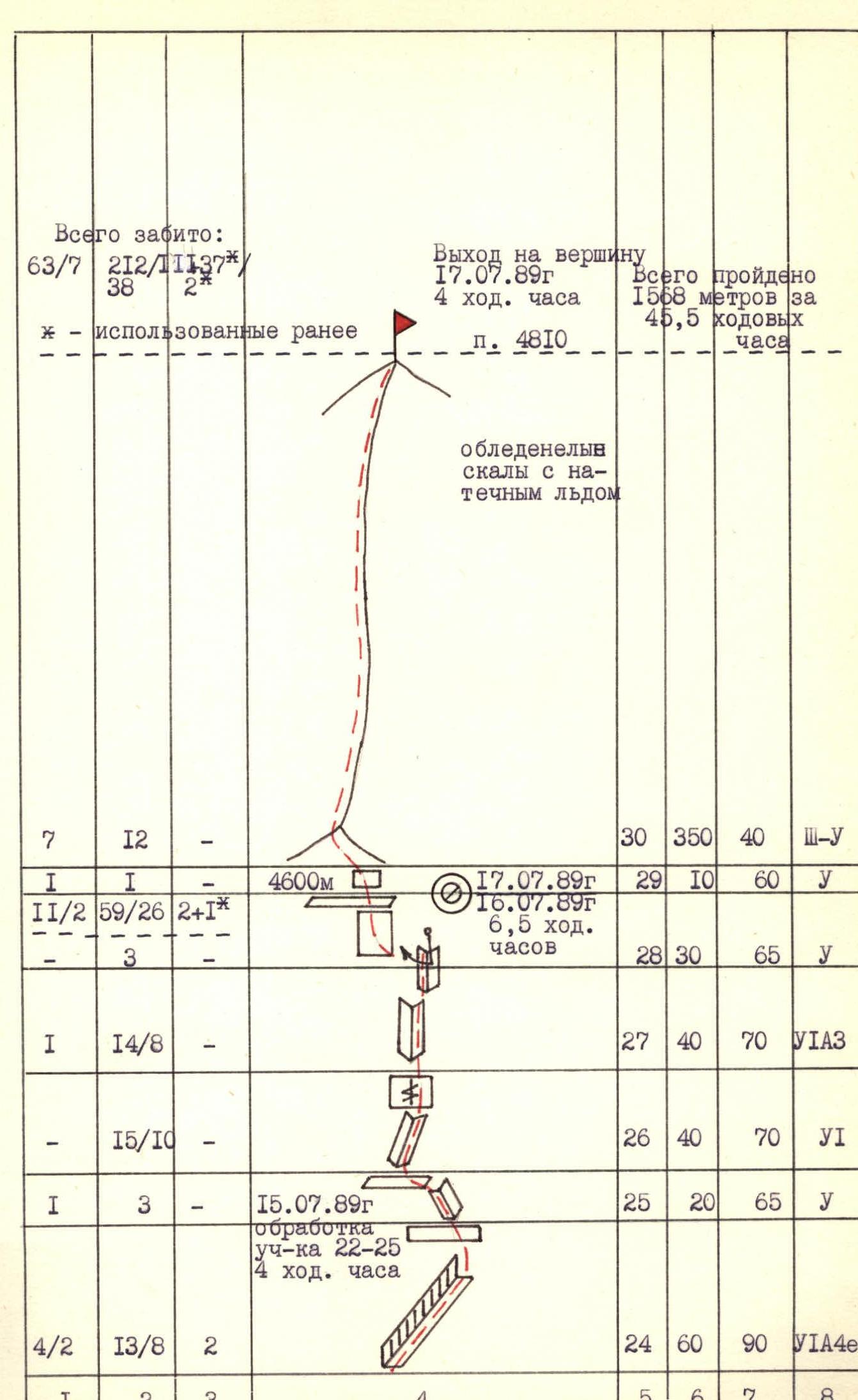
| 63/7 | 2/39 | 212/38 |
\* — previously used.
7. Team's total climbing time: 45.5 hours 8. Overnights: 1st and 2nd on snow shelves lying down, 3rd sitting on a shelf 9. Team leader: Vladimir Ivanovich Parkhachev — Candidate Master of Sports
Larisa Vladimirovna Grzyb — Candidate Master of Sports, Mikhail Vladimirovich Karpenkov — Candidate Master of Sports, Alexander Vladimirovich Lapko — Candidate Master of Sports, Mingalim Minsalimovich Sibayev — Master of Sports of the USSR, Sergey Nikolaevich Skorokhodov — Candidate Master of Sports
10. Coach: Viktor Ivanovich Igolkin — Master of Sports of the USSR 11. Route reconnaissance: July 12–13, 1989
Departure to the route: July 14, 1989, summit: July 17, 1989, return: July 17, 1989.
12. Organization: AUSB "Varzob"

Photo 1. General photo of the summit
- №1 — Kritsuk's route, 6B category difficulty
- №2 — Rusyaev's route climbed by the AUSB "Varzob" team, 6B category difficulty
- №3 — Voronov's route, 6B category difficulty
- №4 — Kopeyka's route, 6B category difficulty
Taken on July 10, 1989, at 17:00 with a "Praktica" camera (GDR), Pentacon lens, focal length 26. Distance to the wall 600 m. Shooting point Φ₁ at an altitude of 3600 m.

Photo 2. Profile of the wall on the right. Taken on July 11, 1989, at 16:00 with a "Praktica" camera, Pentacon lens, focal length 26. Distance to the wall 300 m. Shooting point Φ₂ at an altitude of 3900 m.
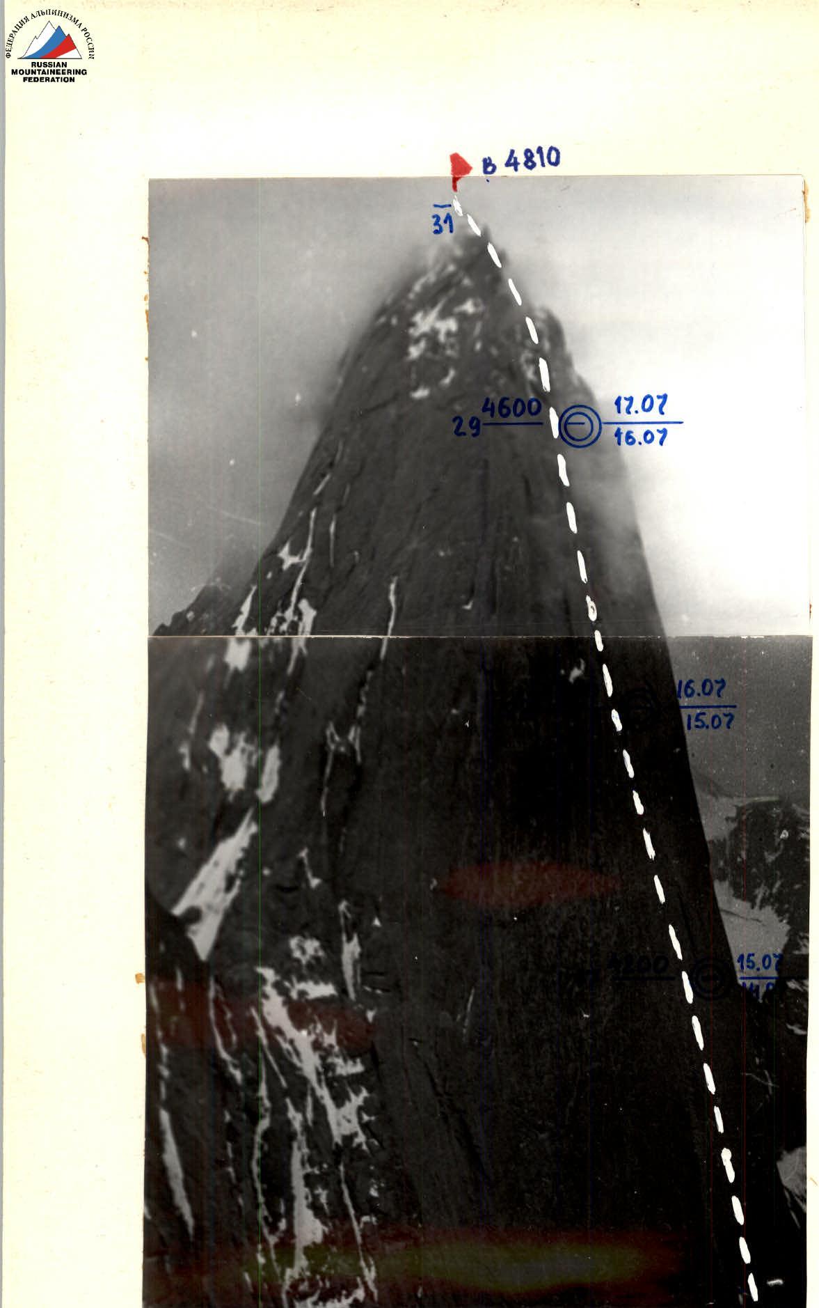
Photo 3. Profile of the wall on the left. Taken on July 3, 1988, at 18:00 with a "Smena-Symbol" camera with a T43 lens, focal length 40 from the 1st overnight stop on the route to Peak 4520 via the right part of the NW wall. Distance to the wall 1000 m. Shooting point Φ₃ at an altitude of 3850 m.
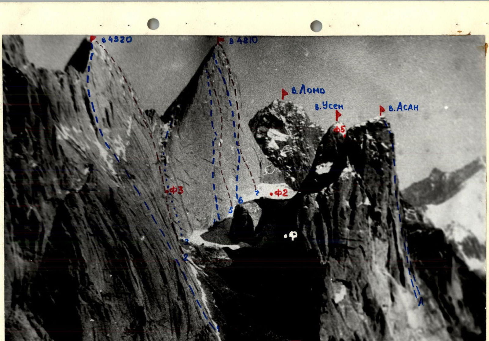
Photo 4. Photopanorama of the area. Taken from a helicopter in 1987. Distance to the object 4 km.
- Route via the left part of the NW wall, 6A category difficulty (Skripko)
- Route via the center of the NW wall, 6B category difficulty (Kopeyka)
- Route via the right part of the NW wall, 6A category difficulty (Igolkin) (Kopeyka)
- Route via the N ridge, 5B category difficulty (Sitnikov)
- Route via the center of the NW wall, 6B category difficulty (Kritsuk)
- Route via the center of the NW wall, 6B category difficulty (Rusyaev)
- Route via the center of the NW wall, 6B category difficulty (Rusyaev)
- A — Routes to Peak Asan via the NW wall, 5B, 6A, 6B category difficulty (Moroz, Pogorelov, Gorbenko, Rusyaev, Timofeev, Alperin)
Team's Tactical Actions
The team's tactical plan provided for two options for climbing Rusyaev's route on Peak 4810 via the right part of the NW wall. The first option, in good weather conditions (bad weather up to 10% of working time per day), planned to complete the route in three climbing days with processing 8 ropes over two days and an overnight stay on the descent after the summit (total 47.5 climbing hours). The second option, in unfavorable weather conditions (bad weather up to 40% of working time), planned to complete the route in four climbing days with processing 8 ropes over two days and an overnight stay on the descent (total 55.5 climbing hours). In unfavorable weather conditions and with significant icing of the upper part of the wall, the route was completed in four days (45.5 climbing hours). The second variant of the tactical plan was executed in terms of climbing days, although the team returned to base camp according to the first variant of the tactical plan.
Such a tactical plan with significant processing was chosen based on the following factors:
- The need to wait in line for the route (after the Sverdlovsk team and before the RSFSR team) and the lack of opportunity to choose more favorable route conditions and weather;
- Poor weather conditions in the current season and, accordingly, the state of the route;
- Poor weather forecast for July 15–17, which required escape routes from the route.
The movement was organized taking into account the work of each rope team and participant as first and last, which created an even load on the participants. Rope teams and participants worked as first on sections in strict accordance with the tactical plan. On sections R0–R29, belays were organized since almost all these sections were of 6th category difficulty. The team used the entire arsenal of modern technical means tested at the USSR championships. Safety was ensured by:
- choosing the direction of movement;
- gathering participants in places closed to accidental rockfall;
- working on a double rope with the use of "Edelrid" UIAA rope as a safety rope in two rope teams and Kaliningrad rope in the middle team.
Overnights:
- N1 and N2 — cut out on ice shelves (lying down);
- N3 — sitting on a shelf.
Due to significant icing of the northern wall (route 5B category difficulty), unstable weather, and planning to reach the summit on the same day by another group via Kritsuk's route, the team decided to descend to the southeast via Nazarov's route (6A category difficulty) and return to base camp through the Ak-Su gorge.
Food was two meals a day (morning and evening) using high-calorie individual rations and a drink in flasks throughout the day. An autoclave was used for food preparation. There were no participant failures or injuries. Difficult sections were overcome with high individual technique, partial use of the "pendulum" technique combined with skyhooks, and a wide range of technical techniques and means. Due to the lack of ledges, intermediate belays were organized on pitons and nuts, and on slabs without cracks — using bolt pitons. New elements included:
- the use of ring ladders sewn into skyhooks for "hook legs" (10–15 cm height gain);
- in addition to skyhooks, bolts with a cable were used — more reliable than ITO in a hole drilled 5–7 mm deep;
Communication with base camp (rescue team) was carried out through two observers (Candidate Master of Sports and 2nd category) constantly located under the route with "Lastochka" and "Karat" radios. Observation was carried out through a 12x binocular, maintaining voice communication in the lower part of the wall.
The team's reserves included:
- good reconnaissance, thorough study of the route (one participant climbed the neighboring Kritsuk's route in 1988);
- significant competitive experience of team members;
- good material base of the expedition (food, equipment, medicine, rescue team);
- one-and-a-half times reserve of food, gasoline, and special equipment;
- effective preparation for the ascent on routes of 6B category difficulty in the same area;
- regular radio communication with the Tajik KSP and AUSB "Varzob" via "Angara" radio and availability of a weather forecast.
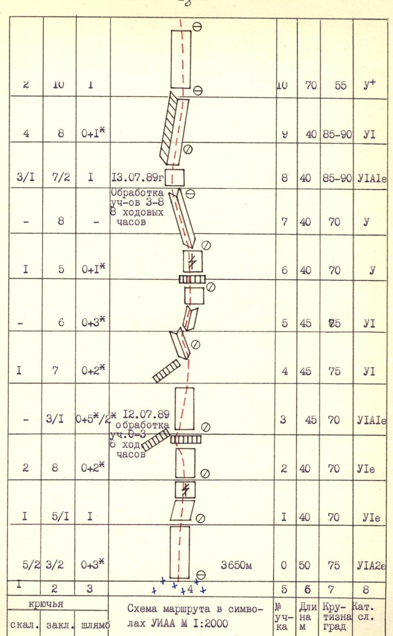
Total pitons used: rock 63/7, nuts 212/38, bolt 2/39. Summit reached: July 17, 1989, 4 hours. Peak 4810. Total distance covered: 1568 m in 45.5 hours. Icy rocks with ice accretion.
| Rock | Nuts | Bolt | Route diagram / Note | Section № | Length (m) | Steepness (°) | Category |
|---|---|---|---|---|---|---|---|
| R30 | 350 | 40 | IV–V | ||||
4600 m July 17, 1989, 16:07.89 (6.5 hours) | R29 | 10 | 60 | У1 | |||
| R28 | 30 | 65 | У1 | ||||
| R27 | 40 | 70 | У1А3 | ||||
| R26 | 40 | 70 | У1 | ||||
| July 15, 1989. Processing sections 22–25, 4 hours. | R25 | 20 | 65 | У1 | |||
| 4/2 | 13/8 | 2 | R24 | 60 | 90 | У1А4е | |
| 2 | 5 | 0/1 | 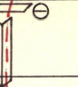 | R23 | 40 | 75 | У1+ |
| 3 | 6 | - |  | R22 | 45 | 75 | У1 |
| 12/1 | 33/2 | 2/11 | 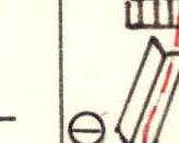 | R21 | 45 | 85 | У1А2е |
| 2 | 5 | 0/1 | R20 | 40 | 80 | У1+ | |
| 1 | 6 | 1/3 | July 14, 1989 | R19 | 40 | 80 | У1 |
| 3 | 7 | 0/3 | Processing sections 17–19, 3 hours. | R18 | 50 | 85 | У1 |
| 2 | 8 | 0/3 |  | R17 | 50 | 85 | У1 |
| 32/4 | 6/10 | 7/27 |  | R16 | 40 | 75 | У1+ |
| 2 | 5 | 0/1 | R15 | 30 | 80 | У1 | |
| 0 | 2/2 | 0/2 |  | R14 | 8 | 90 | У1А2 |
| 2 | 7 | 1/1 | R13 | 45 | 80 | У1 | |
| 4/1 | 9/2 | 2/1 |  | R12 | 45 | 90 | У1А2е |
| 4 | 5 | 1/3 |  | R11 | 45 | 75 | У1 |
Route Description by Sections
R0. The route begins from the rankloft along a monolithic slab without holds. The belay point is on bolt pitons. R1–R2. Monolithic slab with a minimal number of holds. R2–R3. The wall ends in a ledge; belay and belay point via bolt pitons. R3–R4. The ledge is bypassed on the left. Up the slab with a minimal number of holds. Climbing is difficult, using skyhooks; belay via bolt pitons. R4–R5. Bypass the overhang via slabs towards a large diagonal corner. R5–R6. Enter the inclined corner via cracks. R6–R8. Up the corner towards an overhanging corner. R8–R10. Begins a steep, sometimes overhanging, wet corner. Climb up the corner; climbing is difficult, with some use of ITO. R10–R11. Exit from the corner. The wall becomes slightly gentler, but climbing does not become much easier due to smooth rocks from water flowing during bad weather. Reach a shelf. 1st control cairn. R11–R12. The wall starts to steepen. Move first up, then right of a large ledge. R12–R13. Bypass the large ledge on the right. Climbing is difficult, complicated by large cracks and slabs lagging behind the wall, creating the impression of moving on a living huge shell, but they are quite strong. Enter a steep corner to the right of the ledge. R13–R14. Continue up the corner under the ledge. Climbing is difficult. R14–R15. Traverse under the ledge to the right, very difficult with the use of ITO and skyhooks. The ledge is bypassed on the right, and enter a corner. R15–R16. Up the corner to reach a shelf suitable for an overnight stay. Climbing is difficult. R16–R17. Via corners, reach a shelf to the 2nd control cairn. Climbing is somewhat easier. R17–R19. The wall steepens again. Climbing is difficult, but holds are available. Weather deteriorates. Snow begins. R19–R20. Snow-covered, wet rocks. Climb up-right towards a clear corner. Pendulum move. R20–R22. Up the corner to reach a small shelf. Further up the ice-covered right corner under a ledge. Use a bolt for a pendulum move to the left under a corner leading to a shelf. 3rd control cairn. R22–R24. Up a clear corner under a large steep, sometimes hanging, corner going up. R24–R25. Up a corner with a clear 2–5 cm gap. Climbing is extremely difficult. ITO. Reach a shelf. R25–R26. From the shelf, left along a corner to a small ledge. The corner is snow-covered and icy. R26–R27. Internal corner with ice accretion, exiting to the wall. Use of ITO. Climbing is difficult. R27–R28. Series of internal corners with ice accretion. Passed mainly using ITO. Pendulum move from the corner to the wall. Relief ends. R28–R29. Not very steep wall. Passed with free climbing. In the upper part — use of ITO. Reach an overnight stay point. R29–R30. Along a not very steep but icy and snowy slab — exit to the N ridge. R30–R31. Section of a classified route of 5B category difficulty along the N ridge to Peak 4810. The ridge is not pronounced. There are walls and slabs of varying steepness and length. Complicated by weather conditions. Rocks and slabs are covered with a thin layer of snow.
Descent from the summit via the SE wall to the saddle between Peak 4810 and Peak Lomonosov.
 www.alpfederation.ru↗

Photo 5. Technical photo of the route. Taken on July 7, 1989, at 16:00 with a "Praktica" camera, Pentacon lens with a focal length of 26. Distance to the wall 1500 m. Shooting point Φ₅ at an altitude of 3900 m.