Ascent Passport
- Ascent class - technical
- Ascent area - Pamir-Alai, Turkestan Range
- Peak 4810 - via the center of the NW wall (A. Rusyaeva) KTM 5.4.3.II.
- Complexity category - 6B
- Height difference - 1160 m, including: wall - 885 m, length - 1730 m length of sections with 5-6 complexity category - 1410 m, including 6 category - 1330 m (3650-4535). Steepness of the wall section - 74°
- Pitons driven: Rock placements, bolted 123/21 267/29 25/7
- Team's travel hours - 61 and 6 days
- Overnights: 1st, convenient, all in a tent 2nd - "—" 3rd - "—"
- Leader: Ostanin Viktor Vasilyevich - MS
Participants:
- Mingalev Vladimir Nikolaevich - MS
- Mikhailov Andrei Vladimirovich - CMS
- Zhilin Nikolai Fedorovich - CMS
- Fedorov Vyacheslav Anatolyevich - CMS
- Volegov Alexander Vladimirovich - CMS
- Team coach: Ostanin Viktor Vasilyevich
- Departure on the route - July 8, 1989 Summit ascent - July 13, 1989 Return - July 14, 1989
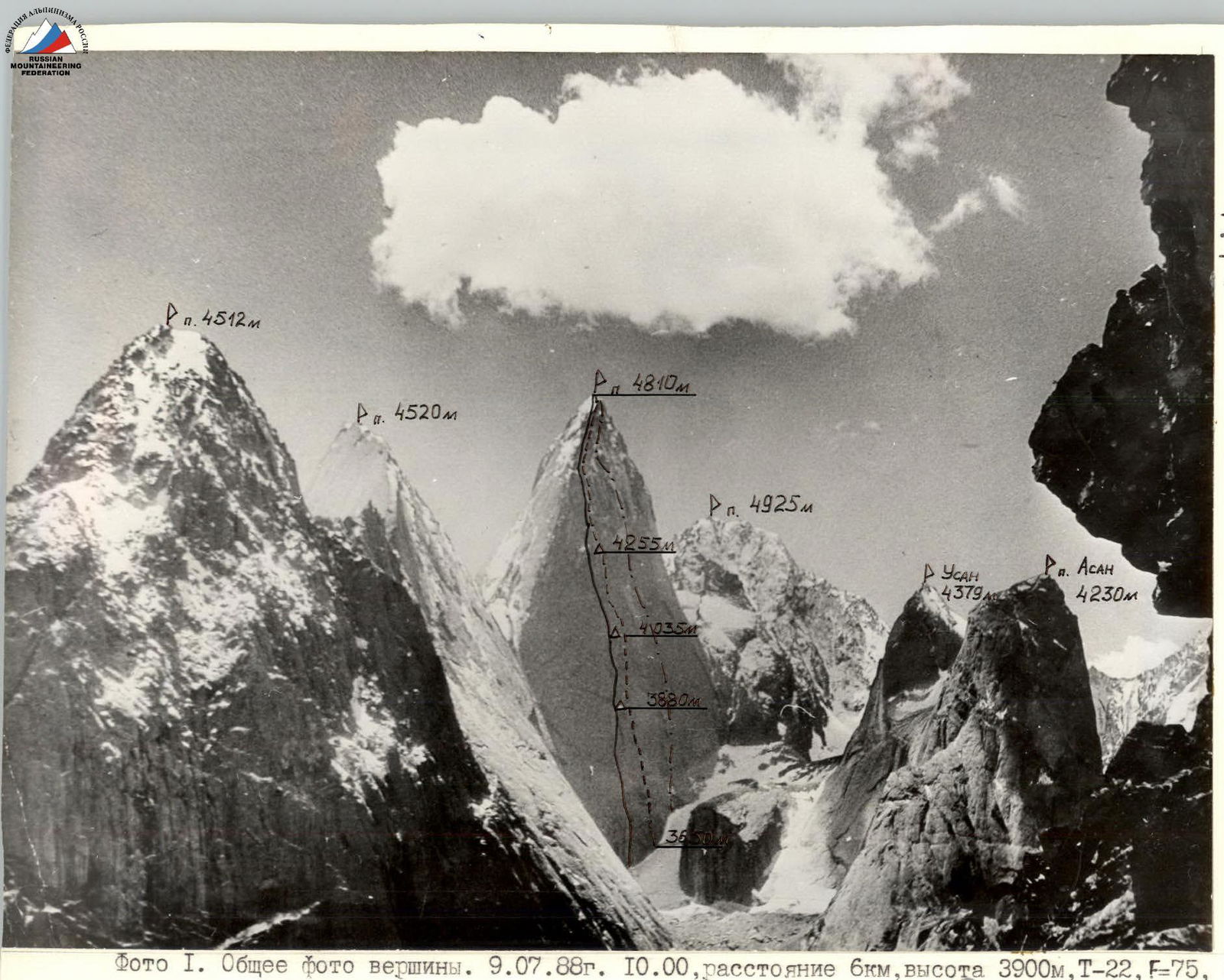 Photo 1. General photo of the summit. 07/09/1988 10:00, distance 6 km, height 3900 m, T-22, F=75, point #1.
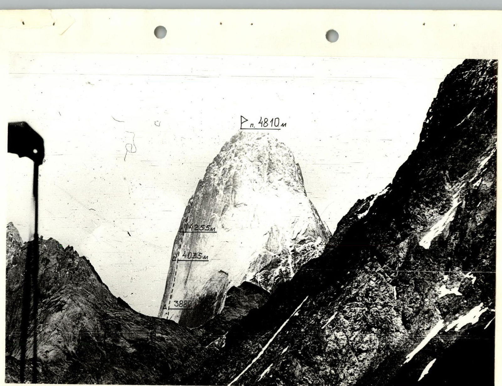 Photo 2. Wall profile from the right. 07/05/1989 15:00, distance 3 km, height 3600 m, "Mir-1B", F=36, point #2.
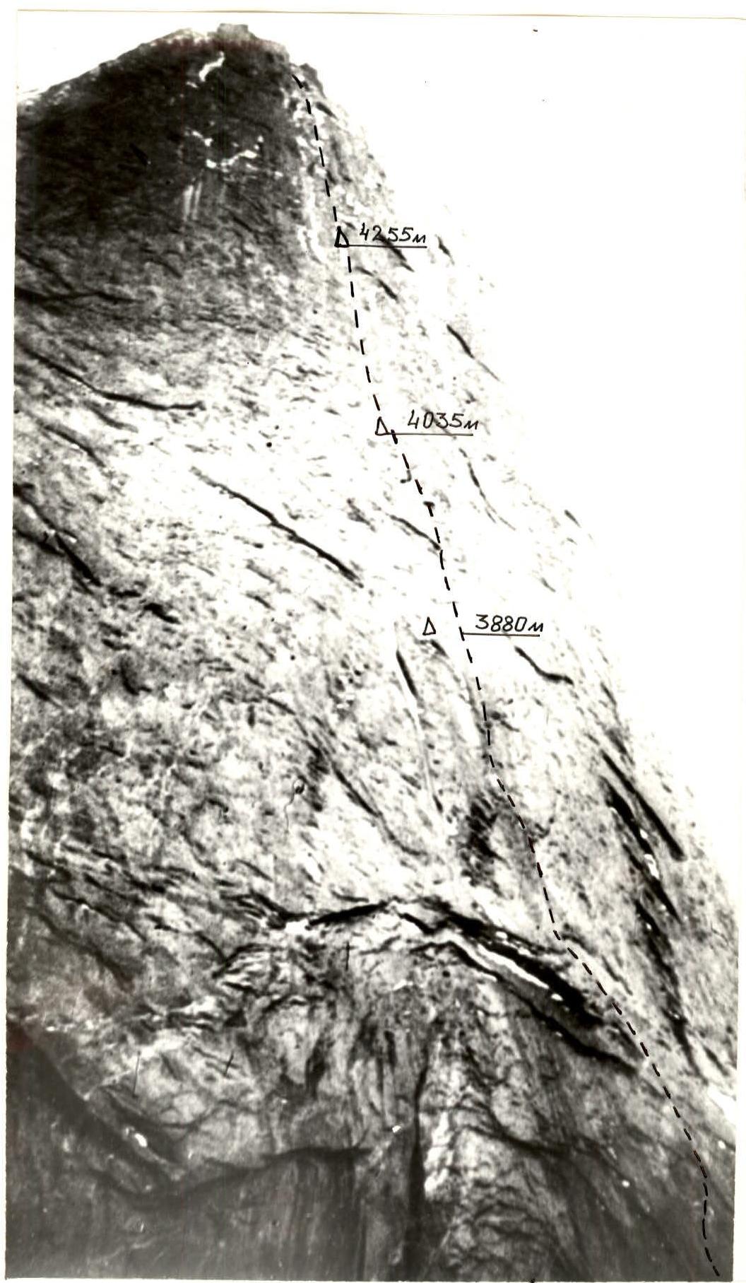 Photo 3. Wall profile from the left. 07/06/1989 17:00, distance 1.5 km, height 3200 m, T-43 lens, F=40, point #3.
Team's Tactical Actions
The team's movement on the route was carried out in accordance with the tactical plan. The route was completed in:
- 4 days of movement
- 2 days of processing
July 8 - according to the tactical plan, the rope team Ostanin - Mikhailov processed the beginning of the route, but due to bad weather, ice was found on the rocks in some places. After lunch, water started flowing, and therefore only 4 ropes were processed. After discussing the complicated situation and possible weather deterioration, the team decided to continue processing the lower part of the wall the next day, according to the backup plan.
July 9 - the rope team Fedorov - Mikhailov passed another 4 ropes, thus enabling the team to start the route.
July 10-13 - the team worked on the route. The movement schedule was strictly followed, and all overnight stays were organized in the planned locations.
Five team members out of six worked as lead climbers:
- Mingalev V. - sections R5-R9, R13-R15
- Mikhailov A. - R21-R22
- Fedorov V. - R3-R5, R12-R13
- Zhilin N. - R17-R21
- Ostanin V. - R0-R3, R9-R12
The change of lead climbers was done within one day and according to the tactical plan or at the participant's personal request.
Thus, the ascent was completed in 61 travel hours with 3 overnight stays on the route, without deviating from the planned plan. The weather during the ascent was surprisingly good.
Safety was ensured primarily by having a wide range of equipment, using UIAA-I ropes, passing fixed ropes on double protection, and organizing overnight stays in convenient locations, allowing for quality food preparation and good rest for the leaders. Hot meals were prepared twice a day, and a "pocket snack" was provided daily.
The team had a set of medications necessary for emergency aid, a radio station type "RTP-2" for communication with observers. During the ascent, a rescue team with the right to exit on a 6B category route was present in the observers' camp or base camp. During the ascent, all waste:
- was burned
- or taken away.
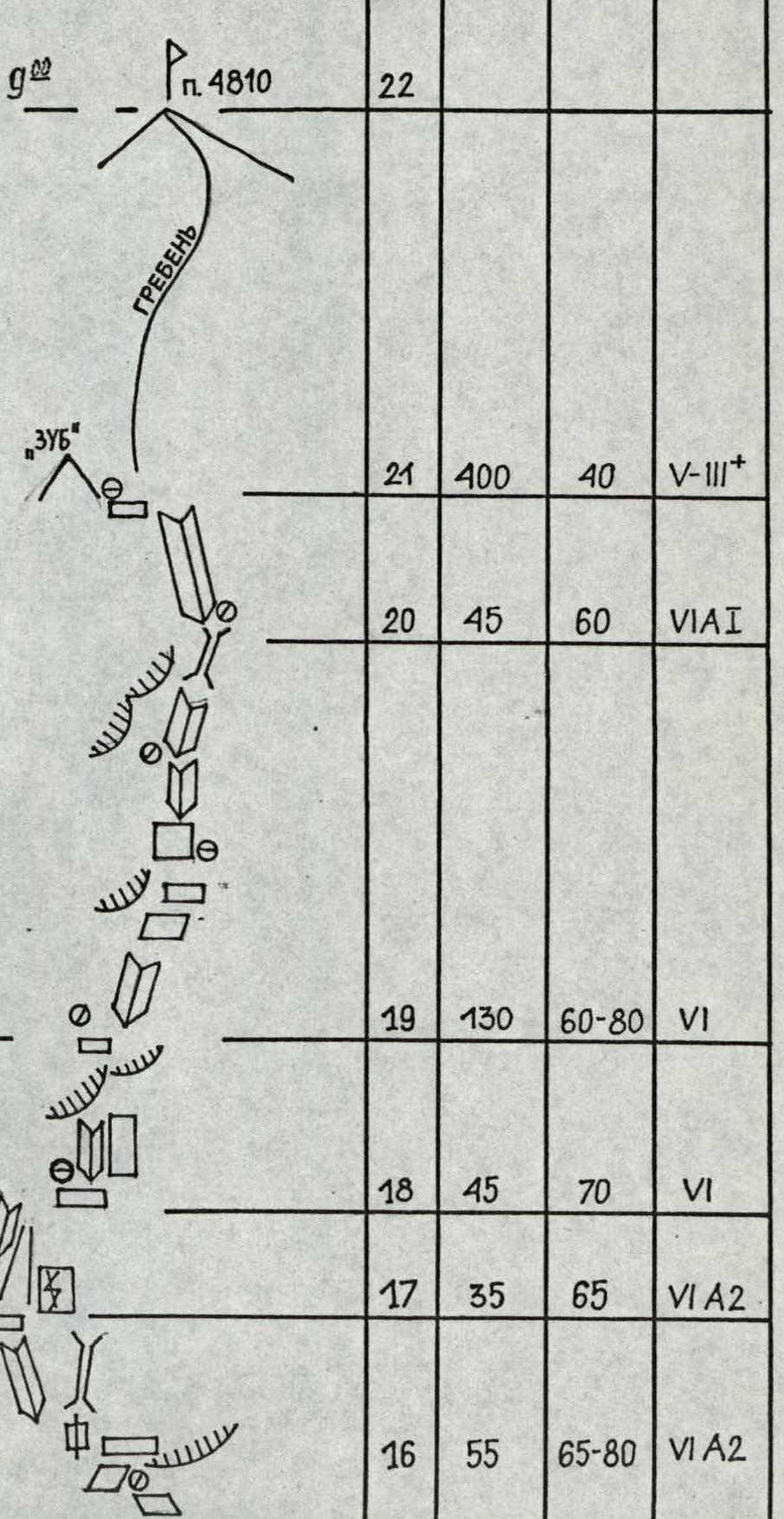
The route was left clean, all pitons were removed, except for the bolts left by the first ascensionists. UIAA symbol route diagram

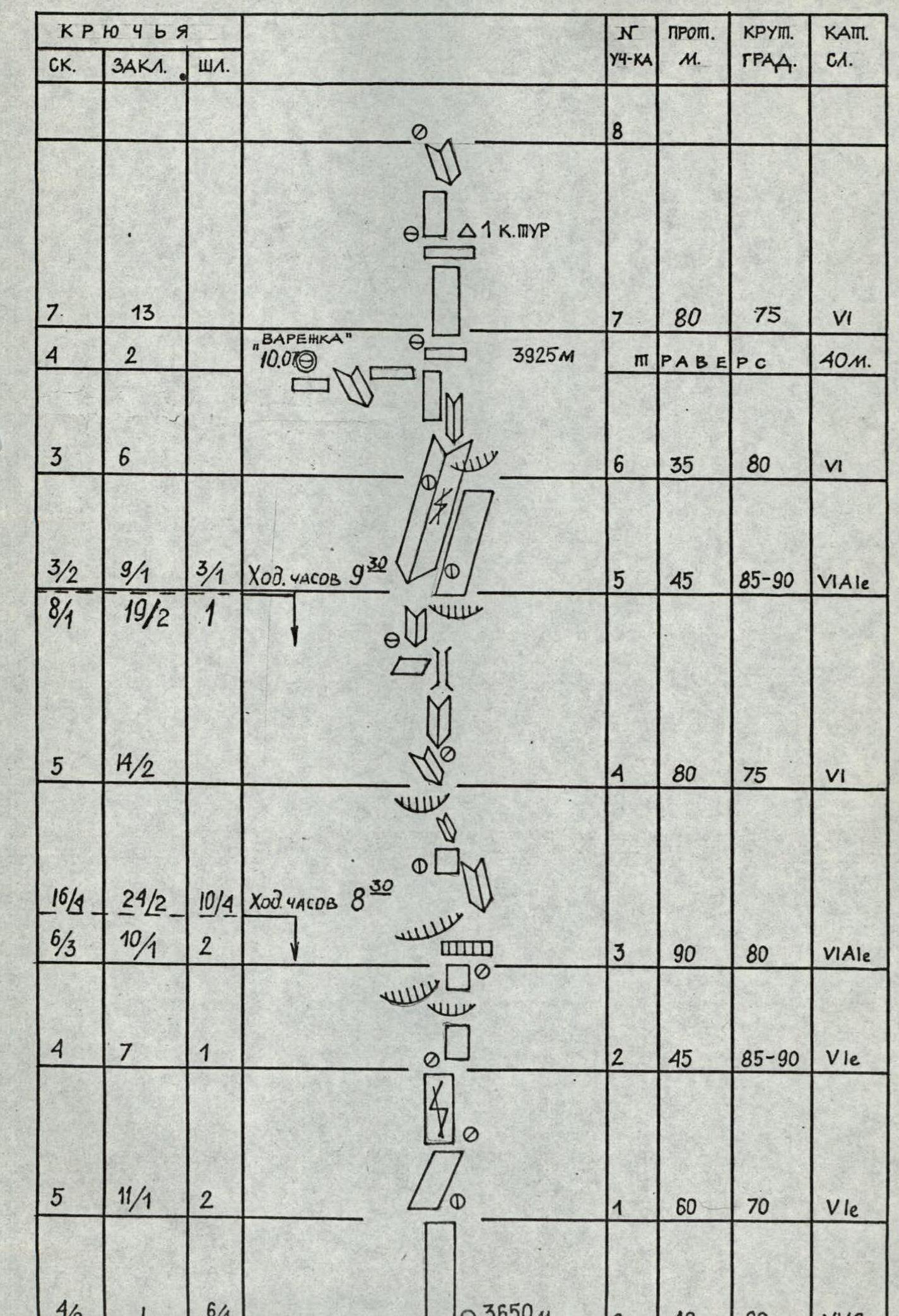
PITONS
| ROCK | PLACEMENTS | BOLTS | SECTION # | INTERM. POINT | STEEPNESS | CATEGORY |
|---|---|---|---|---|---|---|
| 8 | ||||||
| 7 | 13 | 7 | 80 | 75 | VI | |
| 4 | 2 | "GAUNTLET" 10.07 3925m TRAVERSE | 40m | |||
| 3 | 6 | 6 | 35 | 80 | VI | |
| 3/2 | 9/1 | 3/1 | Travel hours 9:30 5 | 45 | 85-90 | VIA1e |
| 8/4 | 19/2 | 1 | ||||
| 5 | 4/2 | 4 | 80 | 75 | VI | |
| 16/4 | 24/2 | 10/4 | Travel hours 8:50 3 | 90 | 80 | VIA1e |
| 6/3 | 10/1 | 2 | ||||
| 4 | 7 | 1 | 2 | 45 | 85-90 | V1e |
| 5 | 11/1 | 2 | 1 | 60 | 70 | V1e |
| 4/2 | 1 | 6/4 | 3650m 0 | 40 | 80 | VIA2e |
PITONS
| ROCK | PLACEMENTS | BOLTS | SECTION # | INTERM. POINT | STEEPNESS | CATEGORY |
|---|---|---|---|---|---|---|
| -16- | ||||||
| 6/2 | 12/1 | 3 | K.MUR 12.07.89. 4255m | 15 | 80 | 75 |
| 6 | 9 | 14 | 60 | 80 | VI | |
| 4 | 7 | 1 | 13 | 45 | 85-90 | V1e |
| 16/4 | 37/7 | 8/2 | Travel hours 10:30 12 | 45 | 85 | VI |
| 2 | 12/4 | |||||
| 9/4 | 9/3 | 7/2 | 2 K.MUR. 11.07.89 4085m 11 | 80 | 80 | VI |
| 4 | TRAVERSE | 40m | ||||
| 3 | 7 | 10 | 35 | 80 | VI | |
| 2 | 9 | 1 | Travel hours 11:00 9 | 40 | 80 | VI |
| 20/5 | 40/1 | 5/1 | ||||
| 7/3 | 12 | 2 | 8 | 80 | 75 | V1e |
PITONS
| ROCK | PLACEMENTS | BOLTS | SECTION # | INTERM. POINT | STEEPNESS | CATEGORY |
|---|---|---|---|---|---|---|
| TOTAL DRIVEN: 123/21 | 267/29 | 25/7 | TOTAL LENGTH: 1730 METERS | |||
| IN 61 TRAVEL HOURS. | ||||||
| 33/8 | 99/10 | Travel hours to p. 4810 22 | ||||
| 14 | 50 | "TOOTH" 21 | 400 | 40 | V-III+ | |
| 4/5 | 7/4 | 20 | 45 | 60 | VIA1 | |
| 7 | 23 | 19 | 130 | 60-80 | VI | |
| 3 | 9 | 18 | 45 | 70 | VI | |
| 5/3 | 10/6 | Travel hours 17 | 35 | 65 | VI A2 | |
| 26/3 | 42/7 | 12:30 | ||||
| 10/1 | 14/6 | 16 | 55 | 65-80 | VI A2 |
Route Description by Sections
R0-R1. Smooth slab with few holds. Passed using skyhooks (Photo 5).
R1-R2. Move right towards a vertical crack, then follow it to a triangular notch.
R2-R3. Up under a large ceiling-type overhang. Caution! Resonant slabs. The overhang is bypassed on the right via a series of small ledges, then onto a shelf.
R3-R4. Rightward movement via climbing through an overhang. Above - coils and another overhang. Very tense climbing (Photo 5).
R4-R5. Move up left via an internal oblique corner under a large yellow corner.
R5-R6. The left face of the corner is destroyed and overhanging, move on the right face. The corner ends in an overhang.
R6-R7. 15 m up and left is a good shelf - top of the "gauntlet", overnight stay #1.
R7-R8. Move up. Shelf for a sitting overnight stay. 1st control point via a small overhang to an implicit internal corner. Then follow it (Photo 7).
R8-R9. Up right, bypassing a ceiling-type overhang, and leaning into an internal corner. Further up under another overhang.
R9-R10. The overhang is bypassed on the right, and via an internal oblique corner up - left onto a shelf. Good spot for belay and overnight stay.
R10-R11. Vertical internal corner. Extreme climbing in wedges. Exit to overnight stay #2. 2nd control point.
R11-R12. Move from the overnight stay up under a stepped overhang, then left to an oblique crack. Polished rocks (Photo 9).
R12-R13. Left up through another oblique crack and along a slab R13-R14 towards a "Г"-shaped internal corner (Photo 10).
R14-R15. The overhang is passed in its right part. Further - under a huge yellow overhang, under it a traverse left and exit onto a shelf, overnight stay #3, 3rd control point.
R15-R16. Left via an internal corner under a large grey overhang.
R16-R17. The overhang is passed on the right at its junction with a slab.
R17-R18. Move along a huge chimney with a transition to the right face.
R18-R19. Move in a gully towards the ridge via a series R19-R20 of internal corners and walls.
R20-R21.
R21-R22. Ridge. Polished rocks, coils.
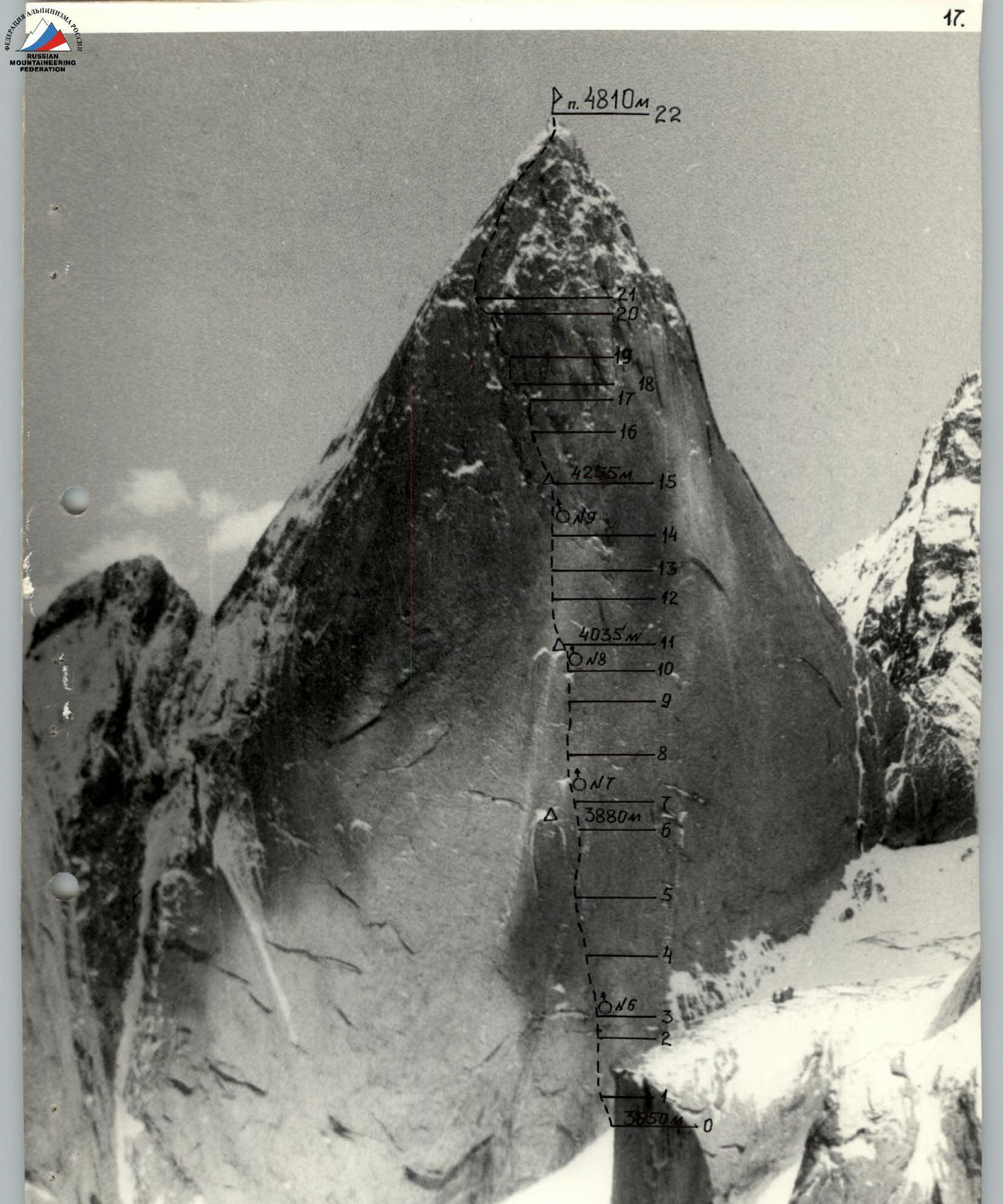 Photo 4. Technical photograph of the route. 07/22/1989 15:00, distance 2.5 km, height 4000 m. T-22, F=75, taken from a helicopter, point #4.
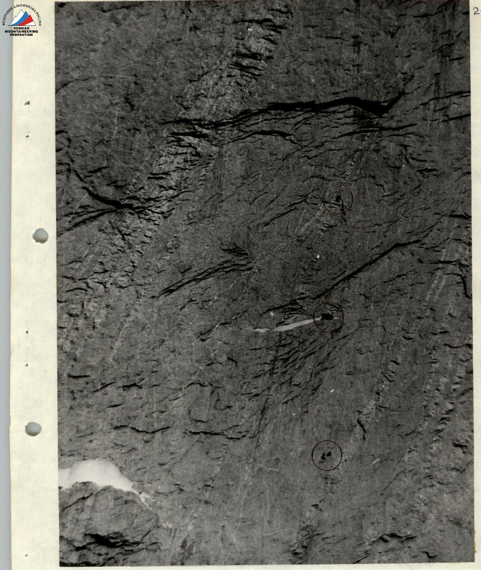 Photo 8. Team movement above overnight stay #1. 07/11/1989 11:00, "Mir-1B", F=36, point #5.
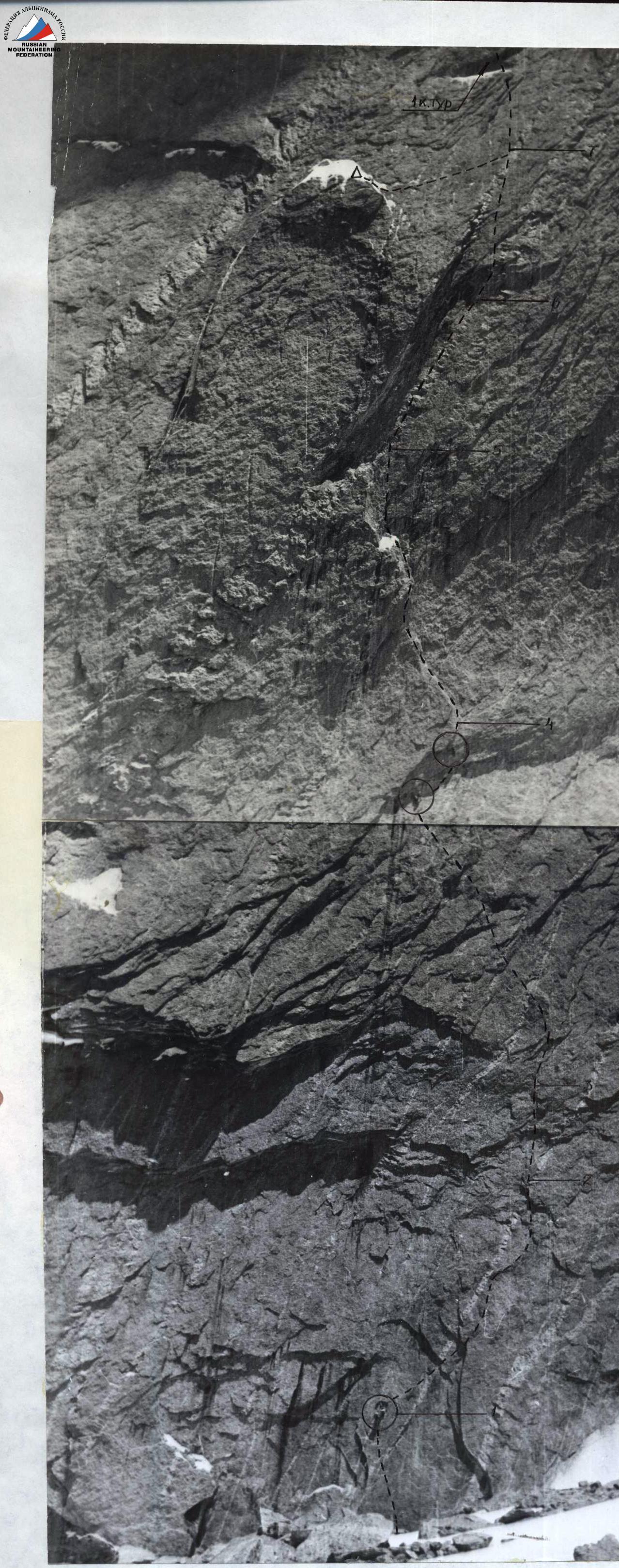
Photo 5. Fragment of a technical photo.
Sections R0-R7. Passing the overhang at the end of section #3. Rope team at the belay point R1. "Mir-1B" lens, F=36, distance 0.4 km, height 3800 m, point #5.