PASSPORT
- Technical class.
- Pamir-Alai, Turkestan Ridge, Northern spur.
- Peak 4810 m.
- First ascent 6B cat. diff. (approximately).
- Route characteristics:
- height difference – 1110 m
- length of 6B cat. diff. sections – 1140 m
- « — » « — » 5B cat. diff. – 300 m
- « — » « — » 4B cat. diff. – 65 m
- average steepness: wall section – 76° until reaching the ridge – 74°
- Pitons hammered:
| rock | bolt | chocks |
|---|---|---|
| 306 | 6 | 59 |
| 49 | 14 | 17 |
- Number of climbing hours: 67 h 30 min (8 days)
- Number of bivouacs:
- total – 7
- of which sitting – 6
- « — » hanging – 1
- Leader: Voronov A.L., alpinism CMS / rock climbing CMS Bankovsky M.G., CMS/ CMS Marchenko V.S., CMS/ CMS Potankin I.V., MS/ MS Tikhomirov V.M., CMS/ CMS Samoylenko I.V., CMS/ CMS
- Coach: Solonnikov V.A., ISMC
- Approach to the route July 2, 1988. Summit reached July 10, 1988. Return to base camp July 11, 1988.
- Team LOS DPhSO trade unions.
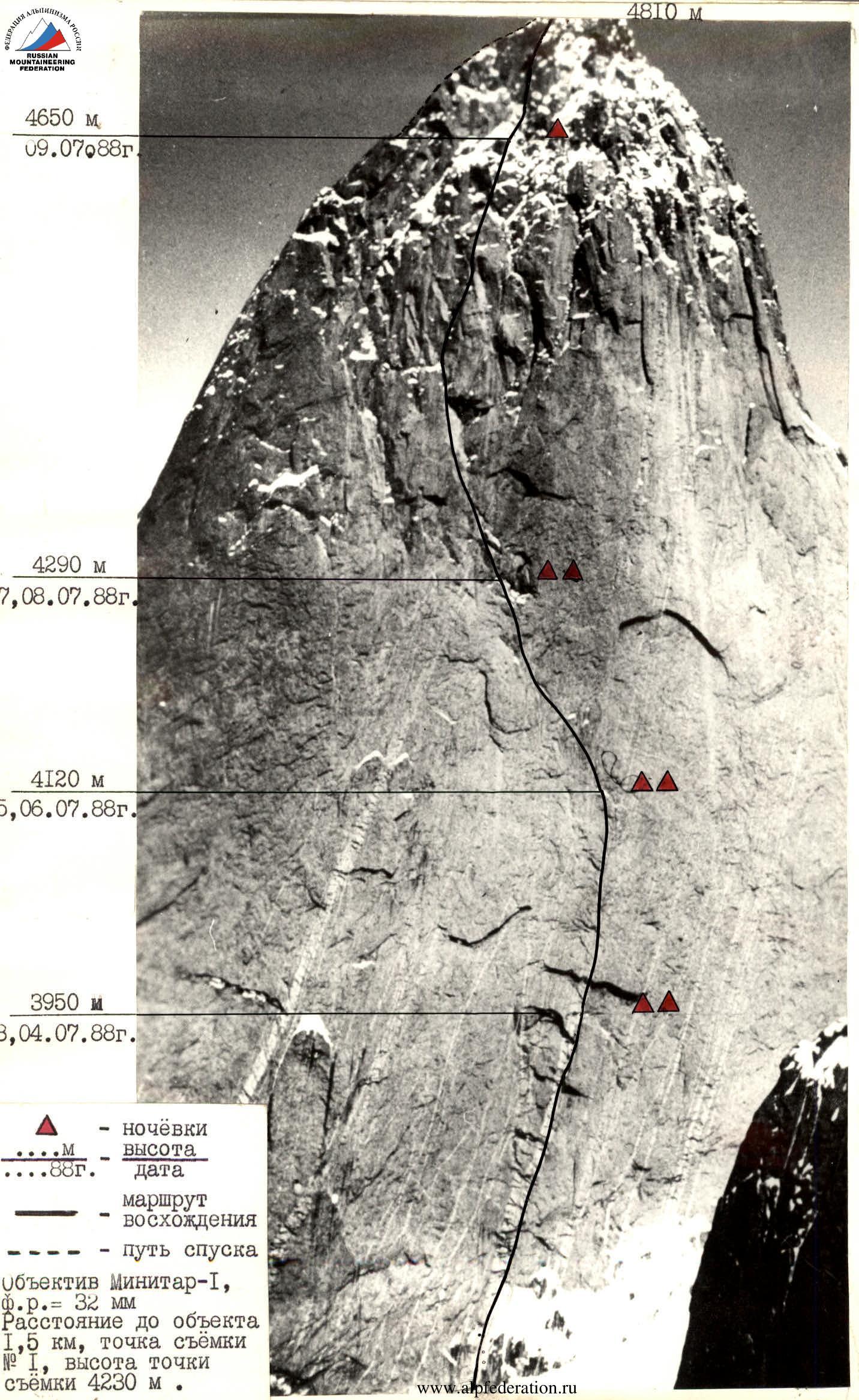
4290 m, July 8, 1988. 4120 m, July 5–6, 1988. 3950 m, July 3–4, 1988. ▲ — bivouacs ....M — height ....88g. — date
— ascent route — descent path Minitar-I lens, f.r. = 32 mm Distance to object 1.5 km, shooting point № 1, height of shooting point 4230 m.
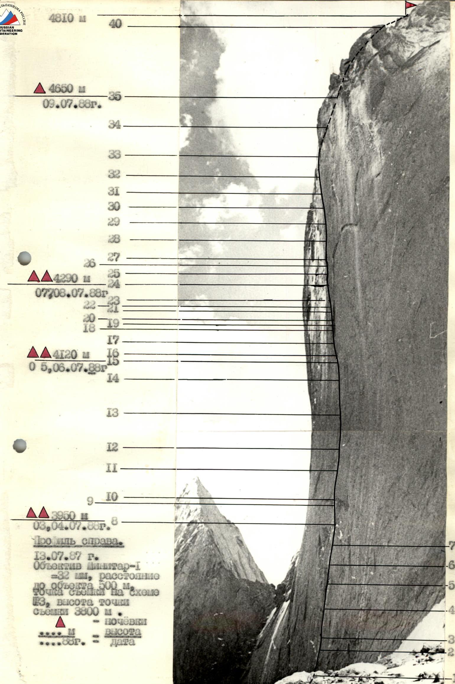
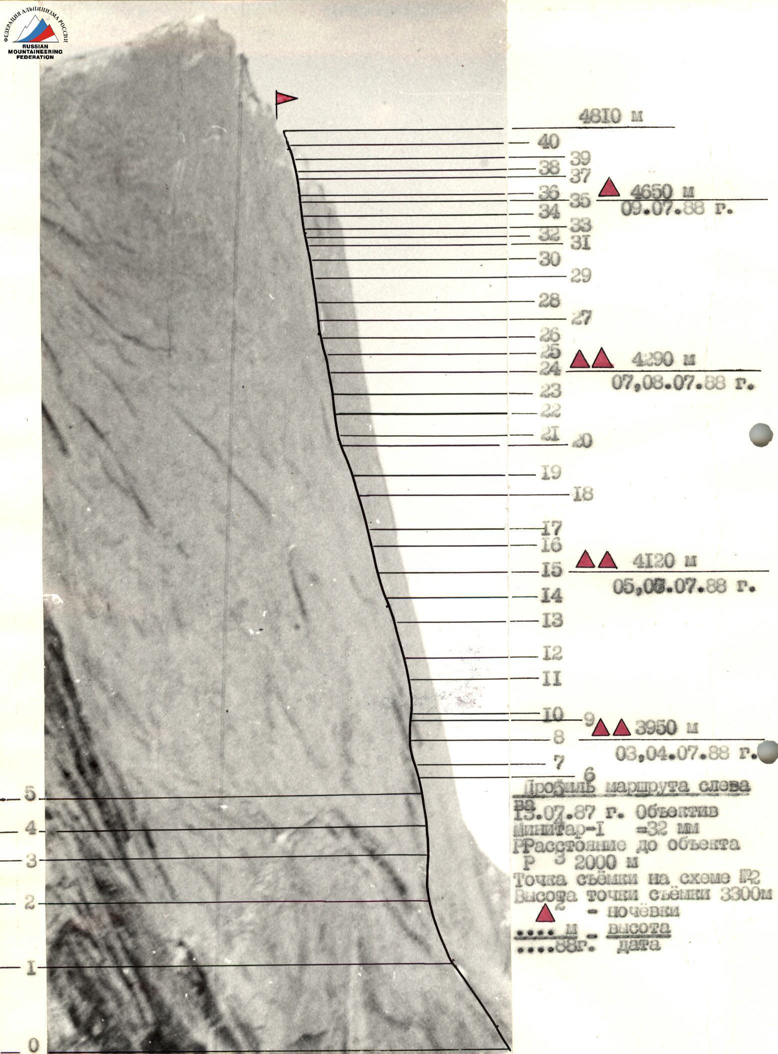
4810 m
40
▲ 4650 m
July 9, 1988.
35 34 33 32 31 30 29 28 27 26
▲▲ 4290 m
July 7–8, 1988.
25 24 23 22–21 20 19 18 17
▲▲ 4120 m
July 5–6, 1988.
16 15 14
13 12 11
9–10
▲▲ 3950 m
July 3–4, 1988.
8
Profile on the right.
July 13, 1987.
Minitar-1 lens
– 32 mm, distance
to object 500 m.
shooting point on the diagram
3, height of shooting point
3300 m
▲ — bivouacs
....M — height
....88g. — date
7 6 5 4 3 2 1
Tactical actions of the team
The team's actions on the route were determined by a pre-developed plan. It was developed and compiled after observing from under the wall through a 60x telescope and detailed review from the summit of Peak Asan (4230 m), which is opposite the ascent object and from which the upper part of the wall is clearly visible. During the ascent to Peak Asan (4230 m), we familiarized ourselves with the rock and terrain that we would be working on at the wall of Peak 4810 m. It is similar in some places, but much longer. Based on these data, a tactical plan was drawn up, which was as follows:
- The route should be logical and pass through the center of the wall with a direct exit to the summit.
- Pass the route as freely as possible with minimal use of bolt technique.
- Not to use special equipment (platforms, etc.) for organizing bivouacs, which simplifies the organization of bivouacs and simplifies the tactics of passing the route. Make maximum use of the wall's relief for organizing bivouacs.
- Since there were no obvious ledges or unambiguous bivouac sites on the chosen route, and the team does not use special equipment for their organization, it was planned to pass sections with processing.
- To maximally lighten the weight by reducing personal and public equipment and high-calorie products (250 g per person per day), which will allow for a quick passage along the route.
The tactical plan included two options for passing the wall:
- Option: to pass the route with 5 bivouacs.
- Option: in case of bad weather, it was planned to have double bivouacs, totaling 7.
Taking into account the real complexity of the route and unfavorable weather conditions, the ascent proceeded according to the II option. July 2, 1988. The team went to process the route (Bankovsky — Voronov — Marchenko). Approximately 100 m were covered. The approach to the route along the snow-ice slope is not included in the report. July 3, 1988. The team ascended to bivouac № 1 and continued processing upwards. (Samoylenko — Voronov — Bankovsky).
The following days the weather worsened. Snow fell, and the route was covered in ice, which thawed in the second half of the day. Therefore, less distance was covered per day than planned in option I. Option II was taken as the main one.
The first in the team worked in galoshes on a double rope of foreign production; to ensure safety, we used:
- shock absorbers on the safety system
- braking devices
All team members worked as lead climbers, but the most difficult sections were passed by:
- Potankin
- Samoylenko
- Bankovsky
The first rope team moved without backpacks, and the last person's backpack was also lightened.
Movement along the fixed ropes was done with top-rope protection on two jumar clamps with prusik knots. All bivouacs on the route were sitting, uncomfortable, and partially used hammocks. The only exception was the bivouac on July 9, where it was possible to set up a tent normally.
Schedule of the first
| date | sections | type of movement | participants |
|---|---|---|---|
| July 2 | R0–R3 | processing | Bankovsky, Voronov, Marchenko |
| July 3 | R3–R11 | movement without processing | Samoylenko, Voronov, Bankovsky |
| July 4 | R11–R13 | processing | Potankin, Voronov, Marchenko |
| July 5 | R13–R16 | movement without processing | Voronov, Potankin, Tikhomirov |
| July 6 | R16–R19 | processing | Samoylenko, Voronov, Tikhomirov |
| July 7 | R19–R21 | processing | Potankin, Voronov, Marchenko |
| July 8 | R21–R26 | movement without processing | Samoylenko, Voronov, Tikhomirov |
| July 9 | R26–R29 | processing | Potankin, Voronov, Bankovsky |
| July 10 | R29–R38 | movement without processing | Marchenko, Voronov, Bankovsky |
The route is a wall with an average steepness of 75–80°. The lower part of the wall is a quartz belt with evenly spaced cornice. The rock is smooth with poor friction. Under the cornices, it is possible to use chock stones. The middle part of the wall is sheer slabs, cracks, internal corners, smooth flakes. In some areas, it is necessary to use a "skyhook" and ITO. Some sections are passed only with pendulum movement. All sections are category VI difficulty. The upper part of the wall is more dissected and represents an alternation of large blocks and smooth structures. Narrow cracks, cornices. Steepness increases to 80°. The pre-summit part of the wall has less steepness. There are sections of category IV–V difficulty. The exit to the summit is along a snow-ice slope and rocks of category III difficulty.
On July 10, 1988, the team reached the summit at 12:00. A note from the ChTS LGSC group dated July 10, 1988, leader Kritsuk A.G., was found, and a note from the "Odessa" Alpine Club dated July 10, 1986, leader Sitnik M.A., was also discovered.
Safety on the route was mainly ensured by the correct organization of movement:
- sheltered gathering places, belays, and bivouacs,
- blocking of pitons,
- movement of participants within vocal and visual contact,
- movement of the first climber on a double rope,
- use of high-quality tested equipment.
Radio communication sessions with observers were conducted according to the schedule. The communication was constant and stable.
Thus, the II variant of the tactical plan was taken as the main one and fully implemented.
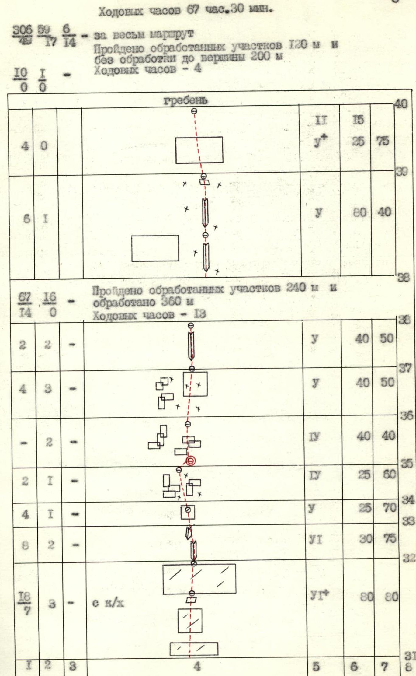
Route diagram in symbols
M 1:2000 /1 mm = 2 m/ in height
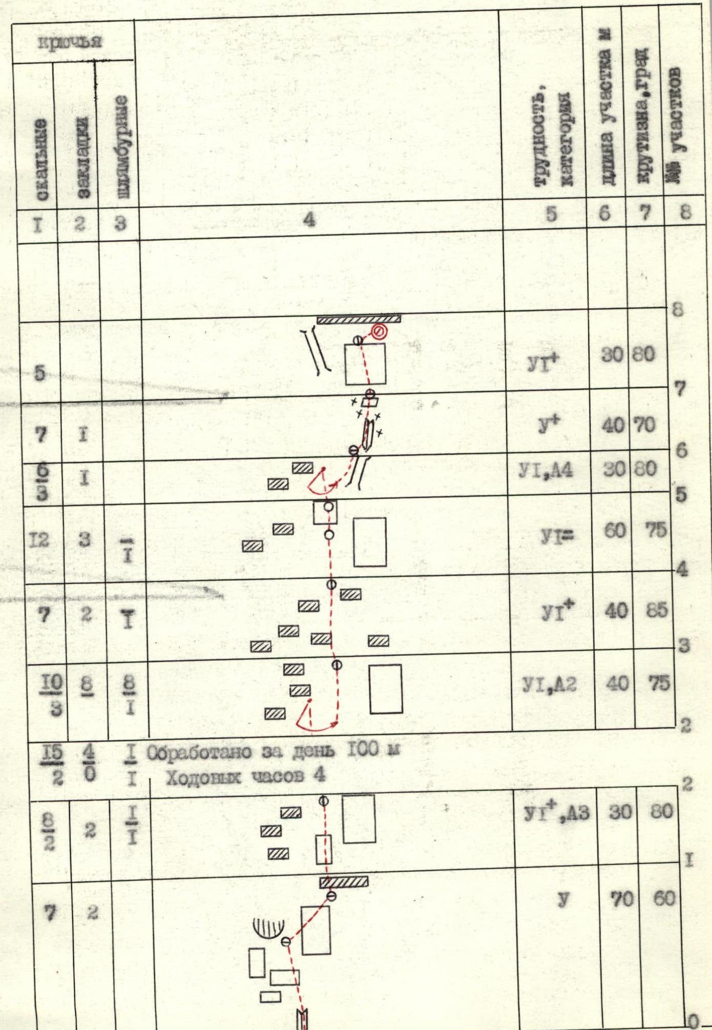
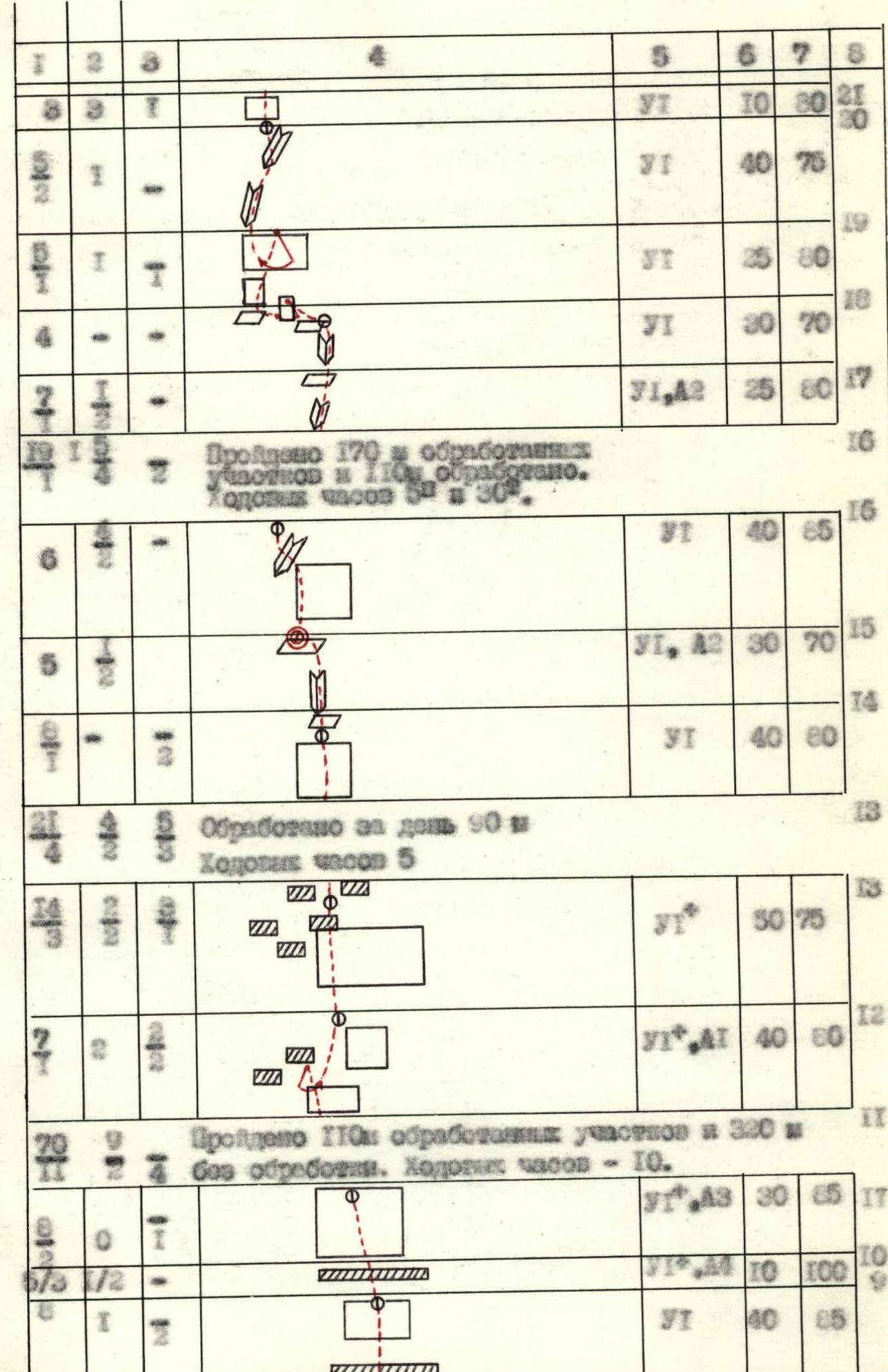
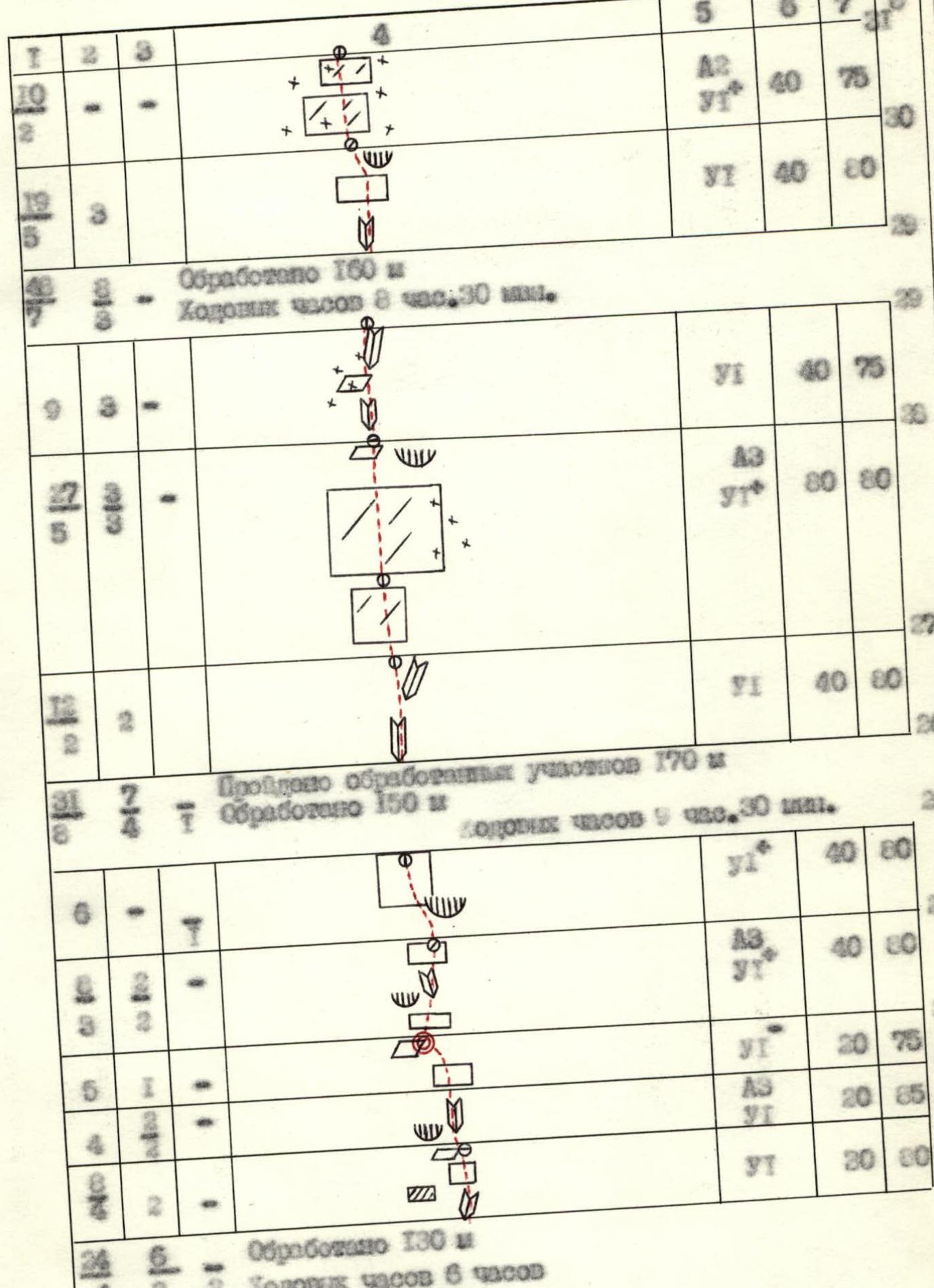
Climbing hours 67 h 30 min.
Description of the route by sections
section R0–R1. Internal corner with exit to broken rocks above the ice, along a wet slab to under a system of cornices. Good belay points. section R1–R2. Smooth slab, with cornices at the top. Climbing is difficult. ITO. section R2–R3. Slab, relief is smooth. From under the cornices, a pendulum move is made. ITO. section R3–R4. Exit through cornices to the right part. Climbing is difficult. Universal pitons. Belay is bolted. section R4–R5. Slab with relief. Cornices. Bypass on the right part. Belay is bolted. section R5–R6. Smooth slab with exit to cornices. Pendulum into the rocks. Belay point is convenient. section R6–R7. Internal corner. Ice. Belay on a ledge. Universal pitons. section R7–R8. Slab with narrow small cracks. Exit to bivouac № 1. section R8–R9. Exit through a cornice along a slab to under a big cornice. Bolted belay. Use of "skyhook". section R9–R10. Cornice, passage in the middle part. Use of ITO. Chock stones. section R10–R11. Slab. In the left part, cracks. Thin universal pitons. ITO. Belay is bolted. section R11–R12. Slabs with poor relief, bypassing cornices on the right side. Use of pendulum. Belay is bolted. section R12–R13. Slab. Cornices at the top. Passage on the right side. Belay through a flake and universal pitons. ITO. section R13–R14. Through cornices, exit to a slab. Movement towards an internal corner. Belay on bolts. section R14–R15. Along an internal corner, exit to bivouac № 2. section R15–R16. Smooth slab, in the left part narrow cracks. Crossing through an internal corner to the wall. Climbing is difficult. ITO. section R16–R17. Internal corner with exit to a ledge. section R17–R18. Internal corner, ice, ledge at the top. Belay point is convenient. Use of pendulum. section R18–R19. Wet slab, along an internal corner, exit to a smooth slab. Belay on bolts. section R19–R20. Pendulum left into an internal corner. Ascent along the internal corner. Smooth flakes. Chocks. section R20–R21. System of internal corners. Universal pitons are used. ITO. section R21–R22. Internal corner with a crack to the right of a cornice. Smooth slab with exit to a ledge under an overhanging cornice. section R22–R23. Internal corner. Use of ITO. Chock stones. section R23–R24. Slab with relief. Exit to bivouac № 3. section R24–R25. Slab. System of internal corners. Use of universal pitons and chock stones. ITO. section R25–R26. Slab with small relief. Overhanging cornice is bypassed on the left side. Belay on bolt pitons. section R26–R27. Internal corner. Universal pitons. ITO. section R27–R28. Smooth slabs with small cracks. Direction of movement to the left edge of a triangular cornice. At the top of the cornice, a "live slab". section R28–R29. Internal corner in ice. Ledge at the top. Possible sitting bivouac. section R29–R30. Internal corner with exit to a slab under a cornice. Small narrow cracks. Use of ITO. section R30–R31. Smooth slabs like "ram's foreheads". Movement along a crack. Wet. Use of "skyhook". section R31–R32. Smooth slabs, wet. Movement along cracks. In the middle part, a ledge convenient for belay. Use of ITO, "skyhook". section R32–R33. System of internal corners. Wet. Chock stones are used. section R33–R34. Wet slabs. section R34–R35. Broken rocks in ice. Exit to bivouac № 4. section R35–R36. Broken rocks. section R36–R37. Rocks in ice, exit to a slab leading to an internal corner. section R37–R38. Internal corner in ice. Belay point is convenient. section R38–R39. Internal corner in ice, leading to a ledge under the ridge. section R39–R40. Wall with relief. Exit to the ridge. Then 40 m along a snow-ice slope and 40 m along broken rocks in ice. Exit to the summit – Peak 4810 m.
Descent along the route 5B cat. diff. (C-3 ridge).