ASCENT DOCUMENT
-
Ascent class — technical
-
Ascent area — Pamir-Alai, Turkestan Ridge
-
Peak 4810 — via the Centre of the East Face
-
Complexity category — 6B (second ascent)
-
Height difference — 1200 m, length — 1290 m, incl. sections of 5–6 cat. diff. — 1000 m, 6 cat. diff. — 550 m. Average steepness — 80°
-
Pitons driven: Rock: 81/12 Nuts: 180/62 Bolts: 3+18x/10x
-
Climbing hours — 46; 5 days (on ascent)
-
Night bivouacs:
- 1st — under the route on a platform
- 2nd — lying in a tent
- 3–4 — separate (3 people in a tent, 2 people in a hammock, semi-sitting)
- 5th — lying in a tent (on descent)
-
Team leader — Yuri Vladimirovich Fedorkov — Candidate for Master of Sports Team members:
- Anton Igorevich Balakai — Candidate for Master of Sports
- Valery Anatolyevich Kirgirin — Candidate for Master of Sports
- Andrey Petrovich Sagurov — Master of Sports
- Dmitry Valeryevich Sidorov — Candidate for Master of Sports
-
Senior team coach — Master of Sports of the USSR Vyacheslav Ivanovich Glushko
-
Team of the MP "Alp-Poisk"
-
Departure to the route — June 27, 1991 Summit ascent — July 1, 1991 Return — July 2, 1991
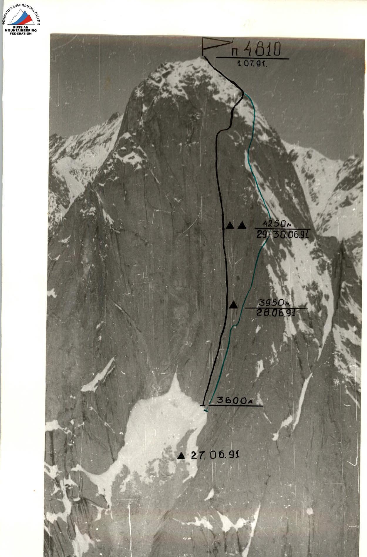
Team's route via the Centre of the East Face of Peak 4810, 6B cat. diff. (Sitnik, 1989) Route via the East Face of Peak 4810, 6A cat. diff. (Vedernikov, 1989) Photo — 1. Date taken — June 2, 1991. Lens — Industar-50. Height — 4200 m. Distance — 1.5 km. Photo number — 1.
TACTICAL ACTIONS OF THE TEAM
The team's objective was the Sitnik route via the Centre of the East Face of Peak 4810, 6B cat. diff., completed in 1989 at the Ukrainian Championship and not yet repeated by anyone. This is the most technically challenging route on the East Face of Peak 4810.
After a detailed study of the route based on existing reports, photographs, and visual observations, a tactical ascent plan was developed. The team was determined to be 5 people:
- Fedorkov Yu.V. — Candidate for Master of Sports, captain
- Sagurov A.P. — Master of Sports
- Balakai A.I. — Candidate for Master of Sports
- Kirgirin V.A. — Candidate for Master of Sports
- Sidorov D.V. — Candidate for Master of Sports.
The tactical plan provided for traversing the route with 4 night bivouacs on the wall; in case of bad weather, an additional reserve day was planned. The route was actually traversed with 3 night bivouacs on the wall and 1 on descent, between June 27 and July 2, in 46 climbing hours. The descent from the summit via the North Ridge, 5B cat. diff., took 11 hours. The ascent occurred in challenging weather conditions. Ascent schedule: June 27 — route processing. The pair Sidorov—Kirgirin covered 4.5 ropes in 5 hours. The "key" section featured cornices and ledges, traversed using artificial aids. The wall's steepness is near-vertical. Work time: 14:30–19:30. June 28 — the entire team started on the wall. The main task was to reach the 1st planned bivouac and process 3 ropes. The plan was fully implemented, with 8.5 ropes covered in a day. The presence of glaze ice in internal corners and cracks hindered progress. The first working pair was Sagurov—Kirgirin. The bivouac was comfortable. Work time: 6:30–19:30. June 29 — the third working day. The task was to reach the 2nd planned bivouac and further process the route. The most complex sections were the "mirror," overhanging flakes of the large internal angle "Africa." Climbing was very challenging, proceeding on feathers and wet rocks. The bivouac was on a snowy ledge (3 people in a tent, 2 in hammocks). Bad weather started at 14:30 — snow, rain, fog. Due to the weather, the working day ended at 15:00. The first working pair was Fedorkov—Sidorov. Work time: 7:00–15:00. June 30 — the fourth working day. The main task was to reach Sitnik's 3rd bivouac. The ascent proceeded via vertical flakes and feathers, at times exiting onto the wall with minimal handholds. Climbing was very difficult. The bivouac site turned out to be poor; under bad weather conditions, it was decided to bivouac at the previous site. It rained throughout the night, water streams from the wall flooded the bivouac. The night was tough. The working day was from 7:00 to 15:00, during which the pair Sidorov—Kirgirin covered 6 ropes. July 1 — the fifth working day. The main task was to reach the summit. After bad weather, the ropes were covered in a thick layer of ice and snow, creating difficulties during the fixed rope passage. Work began at 7:00. Above the processed section, the route goes up an 80-meter wall with cornices, then a psychological traverse to the right, and further along smoothed rocks — exit onto the North Ridge. Bivouac on standard platforms on the ridge. From there, they descended to the summit and returned. Bad weather started at 15:00, fog. The team reached the summit at 18:00. On this day, the pair Kirgirin—Balakai worked ahead. July 2 — descent day. The descent from the summit was chosen via the North Ridge, 5B cat. diff. Descent began at 6:00, return to base camp at 17:00.
Safety measures during the route included:
- High physical, technical, and psychological preparedness of team members, who underwent a 25-day training camp and completed training ascents of 5–6 cat. diff.
- A tactical plan, developed considering the area's specifics (all ascent participants had been here multiple times).
- Good material support, including the use of modern specialized mountaineering equipment on the route.
- Ensuring all participants had double top-rope protection on the route, with the first climber working on a double rope (UIAA+USSR).
- Presence of a safety group under the route, with a specific plan of action in case of an emergency.
- Presence of an observation group under the route, ensuring stable radio communication between the team and the base camp.
- Presence of long-range radio communication with the KSP Tajik SSR in the base camp.
There were no falls or injuries during the ascent. On the route, a two-course hot meal and a daily pocket snack were planned. Nutrition was calculated at 300 g of products per day.
ROUTE SCHEME IN UIAA SYMBOLS
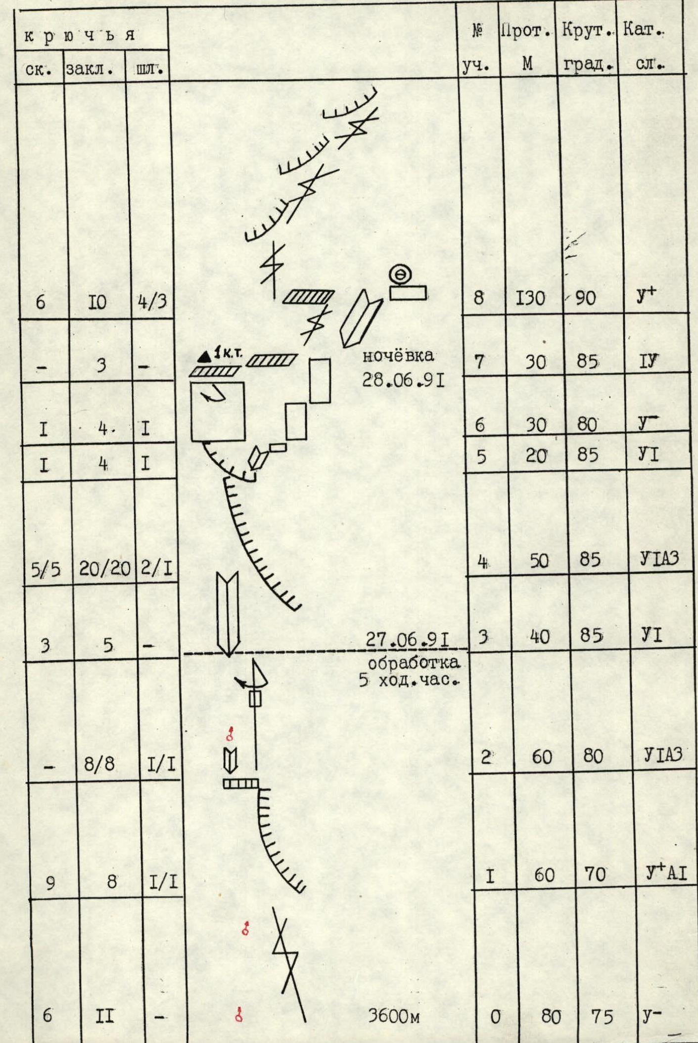
| Sect. # | Length (m) | Steepness (°) | Cat. diff. | Rock pitons | Nut pitons | Bolt pitons |
|---|---|---|---|---|---|---|
| 0 | 80 | 75 | Y- | 6 | 11 | - |
| 1 | 60 | 70 | Y+A1 | 9 | 8 | 1/1 |
| 2 | 60 | 80 | UIAA-III | - | 8/8 | 1/1 |
| 3 | 40 | 85 | VI | 3 | 5 | - |
| 4 | 50 | 85 | UIAA-III | 5/5 | 20/20 | 2/1 |
| 5 | 20 | 85 | VI | 1 | 4 | 1 |
| 6 | 30 | 80 | Y- | 1 | 4 | 1 |
| 7 | 30 | 85 | IV | - | 3 | - |
| 8 | 130 | 90 | Y+ | 6 | 10 | 4/3 |
| 9 | 20 | 85 | Y- | 2 | 1 | - |
| 10 | 80 | 85 | UIAA-III | 1 | 9 | 5/4 |
| 11 | 20 | 85 | IV | 1 | 2 | - |
| 12 | 40 | 85 | UIAA-II | 5/3 | 10/9 | - |
| 13 | 15 | 85 | UIAA-III | 3/3 | 7/7 | - |
| 14 | 65 | 85 | UIAA-I | 5 | 10 | - |
| 15 | 40 | 80 | UIAA-III | 5/1 | 13/12 | - |
| 16 | 40 | 80 | VI | 3 | 8 | - |
| 17 | 70 | 80 | Y- | 5 | 6 | - |
| 18 | 40 | 80 | UIAA-III | 2 | 10/6 | 2 |
| 19 | 60 | 80 | UIAA-III | 5 | 10/6 | 1 |
| 20 | 40 | 75 | Y- | 3 | 6 | - |
| 21–22 | 20 | 70 | III | 1 | - | - |
| 23 | 40 | 70 | IV | - | 5 | - |
| 24 | 80 | 65 | III–IV | 3 | - | - |
| 25 | 100 | 45 | III | 6 | - | - |
Total pitons driven: Rock 81/12, Nuts 180/62, Bolts 21/10. Total length: 1290 m, 46 climbing hours.
 Peak 4810. Summit ascent on July 1, 1991, 6 hours 30 minutes of climbing time.
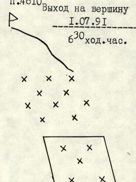

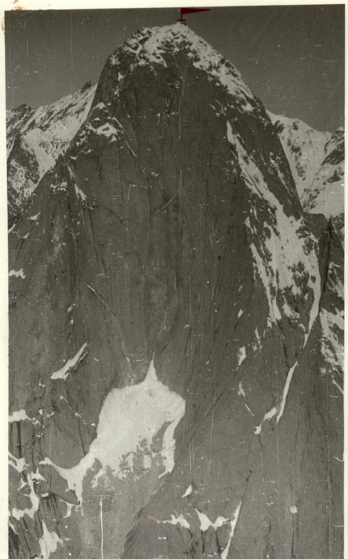
PHOTO ILLUSTRATION OF THE REPORT
Photo — 6. Peak 4810. View from the East.

Photo — 7. Lower part of the route. View from section 0–1.
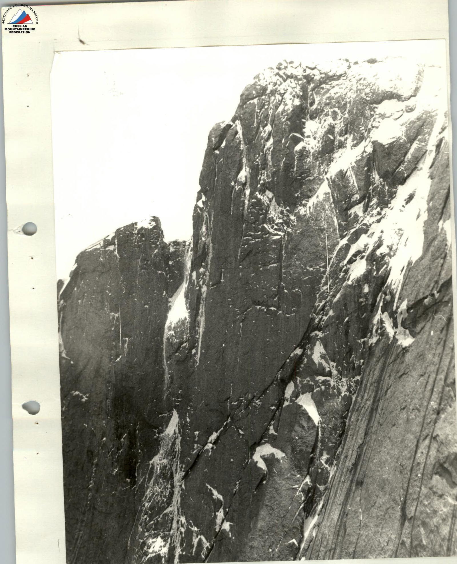
Photo — 14. View from the second bivouac to the wall.