ASCENT DOCUMENT
- Technical category.
- Pamir-Alay, Turkestan Range, Karavshin river basin.
- P. 4810 — via N wall.
- 6A category of difficulty, first ascent.
- Height difference:
| total | wall section | |
|---|---|---|
| length | 1095 m | 815 m |
| average steepness | 62° | 69° |
| length of sections | 5th category of difficulty | 225 m |
| 6th category of difficulty | 355 m |
- Pitons driven:
| rock | chocks | slings | ice |
|---|---|---|---|
| 37 | 128 | 0 | 0 |
| 2 | 7 | 0 | 0 |
-
Climbing hours: 18 + (5 hours descent) days 2.
-
Overnight stays: sitting, in a tent + hammocks.
-
Leader: Kotelnikov A.I. — MS
Participants:
- An P.V. — MS
- Bukreev V.V. — MS
- Zaikin A.A. — CMS
- Kolabushkin B.A. — CMS
- Selyaev V.V. — MS
Coaches:
- Shabanov A.V.
- Kudakaev T.Z.
-
Departure to the route July 18, 1992, summit July 19, 1992, descent to the tourist camp July 20, 1992
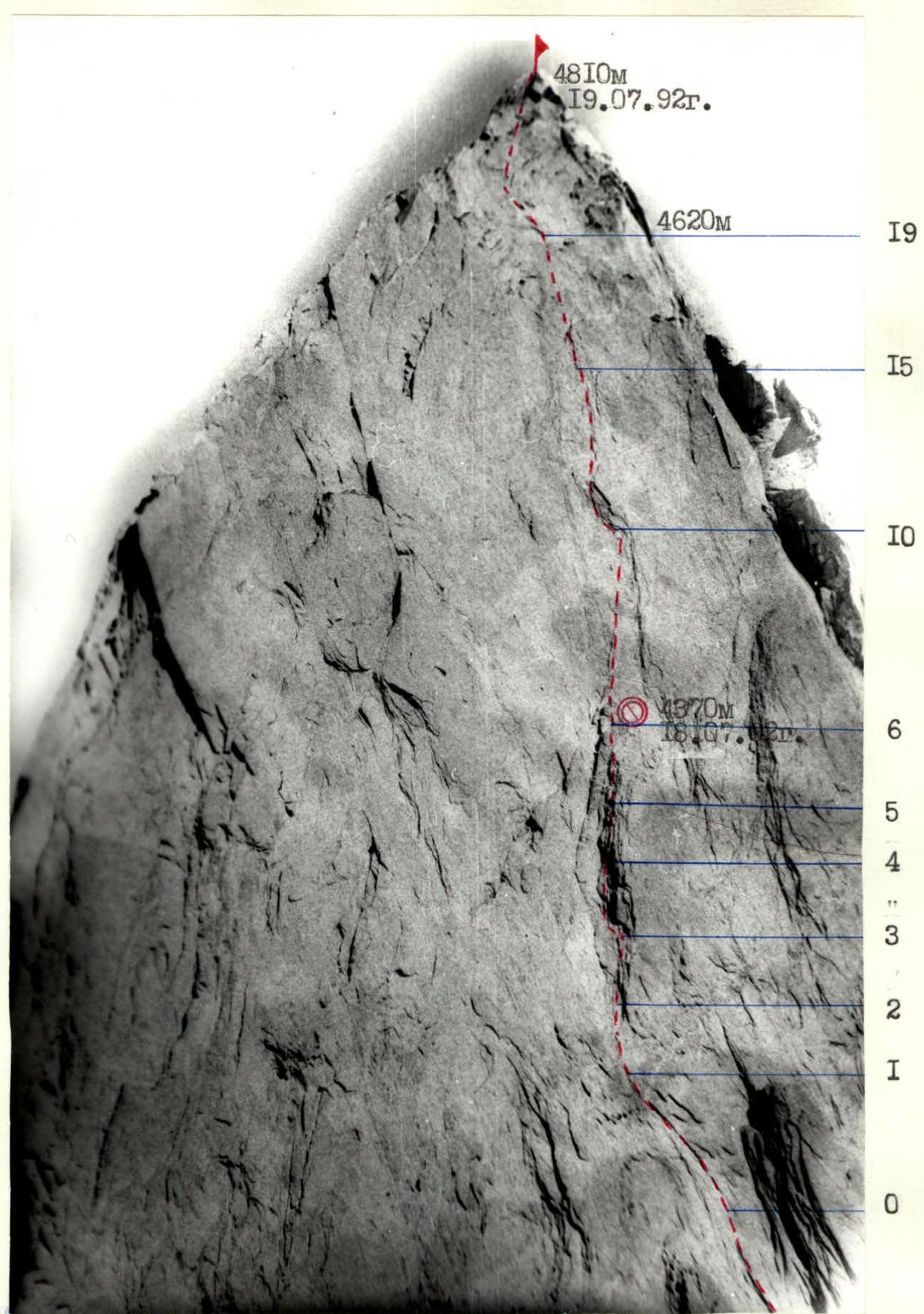
BELAY POINTS AND ROUTE SCHEME IN UIAA SYMBOLS
| Rock | Chocks | Slings | Ice | Section # | Category of difficulty | Length | Steepness | Additional info |
|---|---|---|---|---|---|---|---|---|
| 3 | 7 | 0 | 0 | R10 | 6 | 45 m | 75° | |
| 2 | 6 | 0 | 0 | R9 | 5+ | 45 m | 70° | |
| 4 | 7 | 0 | 0 | R8 | 6+ | 45 m | 65° | A2 |
| 1 | 5 | 0 | 0 | R7 | 5 | 45 m | 65° | |
| 0 | 5 | 0 | 0 | R6 | 4 | 45 m | 65° | IC. July 18, 1992, rock–9, chocks–33, 4370 m |
| 4 | 8 | 0 | 0 | R5 | 6 | 40 m | 75° | A2 |
| 1 | 6 | 0 | 0 | R4 | 5 | 45 m | 70° | |
| 2 | 4 | 0 | 0 | R3 | 5 | 45 m | 70° | |
| 0 | 1 | 0 | 0 | R2 | 3 | 20 m | 40° | |
| 0 | 6 | 0 | 0 | R1 | 5 | 45 m | 65° | |
| 2 | 4 | 0 | 0 | R0 | 4 | 45 m | 60° | 4000 m |
| 0 | 6 | 0 | 0 | R20 | 2 | 120 m | 40° | 4810 m July 18, 1992 |
| 1 | 2 | 0 | 0 | R19 | 4 | 16 m | 60° | |
| 3 | 10 | 0 | 0 | R18 | 4 | 150 m | 45° | 4620 m |
| 2 | 4 | 0 | 0 | R18 | 4 | 45 m | 60° | |
| 0 | 5 | 0 | 0 | R17 | 4 | 45 m | 60° | |
| 2 | 6 | 0 | 0 | R16 | 5 | 45 m | 65° | |
| 2 | 5 | 0 | 0 | R15 | 6 | 45 m | 75° | A2 |
| 1 | 6 | 0 | 0 | R14 | 6 | 45 m | 75° | A2 |
| 3 | 5 | 0 | 0 | R13 | 6+ | 45 m | 80° | A2 |
| 3 | 8 | 0 | 0 | R12 | 6+ | 45 m | 80° | A2 |
| 3 | 5 | 0 | 0 | R11 | 6 | 45 m | 80° |
Route description for P. 4810 m via N wall, first ascent, 6A category of difficulty, approximately by sections
R0–R1. From the saddle along medium-difficulty rocks towards the ridge. Rocks are icy, 45 m, 60°, 4.
R1–R2. Ridge, monolithic rocks are "mossy!". After bad weather, very difficult climbing, 45 m, 65°, 5.
R2–R3. Inclined shelf, to the left rocks are slippery, 20 m, 55°, 3.
R3–R5. Up along the rock spall, monolithic rocks. Passed in wedging, 100 m, 70–75°, 5.
R5–R6. Exit from the spall to the right. Cornice is passed in the right part, 40 m, 75°, 6.
R6–R7. Rocky ridge. Site for overnight stay for 4 people, for a pair there is a place 10 m higher.
R7–R8. Cleft. Passed by free climbing, 45 m, 65°, 5.
R8–R9. Cleft. In the upper part passed using aid climbing, 45 m, 65°, 5+, A2.
R9–R10. Rocky wall. Wet rocks, 45 m, 70°, 5+.
R10–R11. Smooth wet rocks. Passing the cornice in the left part. Problematic organization of belay points, 45 m, 75°, 6.
R11–R13. Smooth wall. For passage, skyhooks are used, 90 m, 80°, 6, A2.
R13–R14. Wall with a cleft. Overcome by free climbing. For belaying, friends go well, 45 m, 80°, 6.
R14–R16. Along the wall left-up towards the summit tower, 90 m, 70°, 5-6.
R16–R19. Exit to the edge under the summit, 90 m, 60°, 4.
R19–R20. Sharp rocky ridge. Passed on the left side, 150 m, 45°, 4.
R20–R21. Snow ridge leads to the summit, 120 m, 40°, 2.
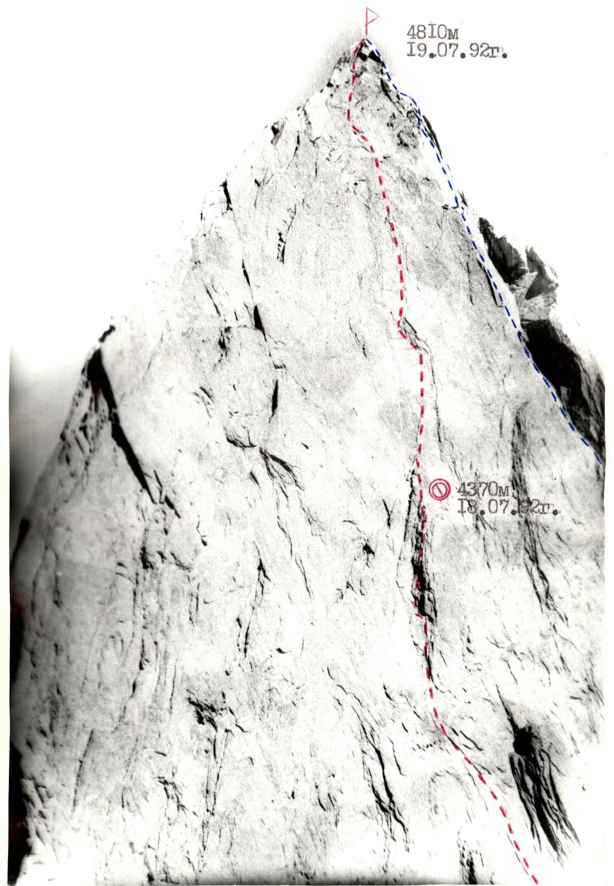
GENERAL PHOTO OF THE SUMMIT Conventions: — group member — member of the a/c group from Odessa, 1986
 TECHNICAL PHOTOGRAPHY OF THE ROUTE
Taken on July 17, 1992, 14:00. Camera "Lomo-Compact". Distance — 2 km.
TECHNICAL PHOTOGRAPHY OF THE ROUTE
Taken on July 17, 1992, 14:00. Camera "Lomo-Compact". Distance — 2 km.