Russian Championship in Alpinism
high-altitude and technical category 2018 year
Report
on the ascent to peak Kyrkchilta, 4507 m, via the center of the SW wall, 6B category of difficulty, Dave route by the team from Krasnoyarsk For the period 23.07.2018–25.07.2018
I. Ascent Passport
| 1. General Information | ||
|---|---|---|
| 1.1 | Full name, sports rank of the team leader | Prokofyev D.E. (MS) |
| 1.2 | Full name, sports rank of the team members | Polunin V.L. (MS) Popova M.E. (MS) |
| 1.3 | Full name of the coach | Zakharov N.N. (MSMK), Balezin V.V. (MSMK), Prokofyev D.E. (MS) |
| 1.4 | Organization | Krasnoyarsk Krai Federation of Alpinism |
| 2. Characteristics of the Ascent Object | ||
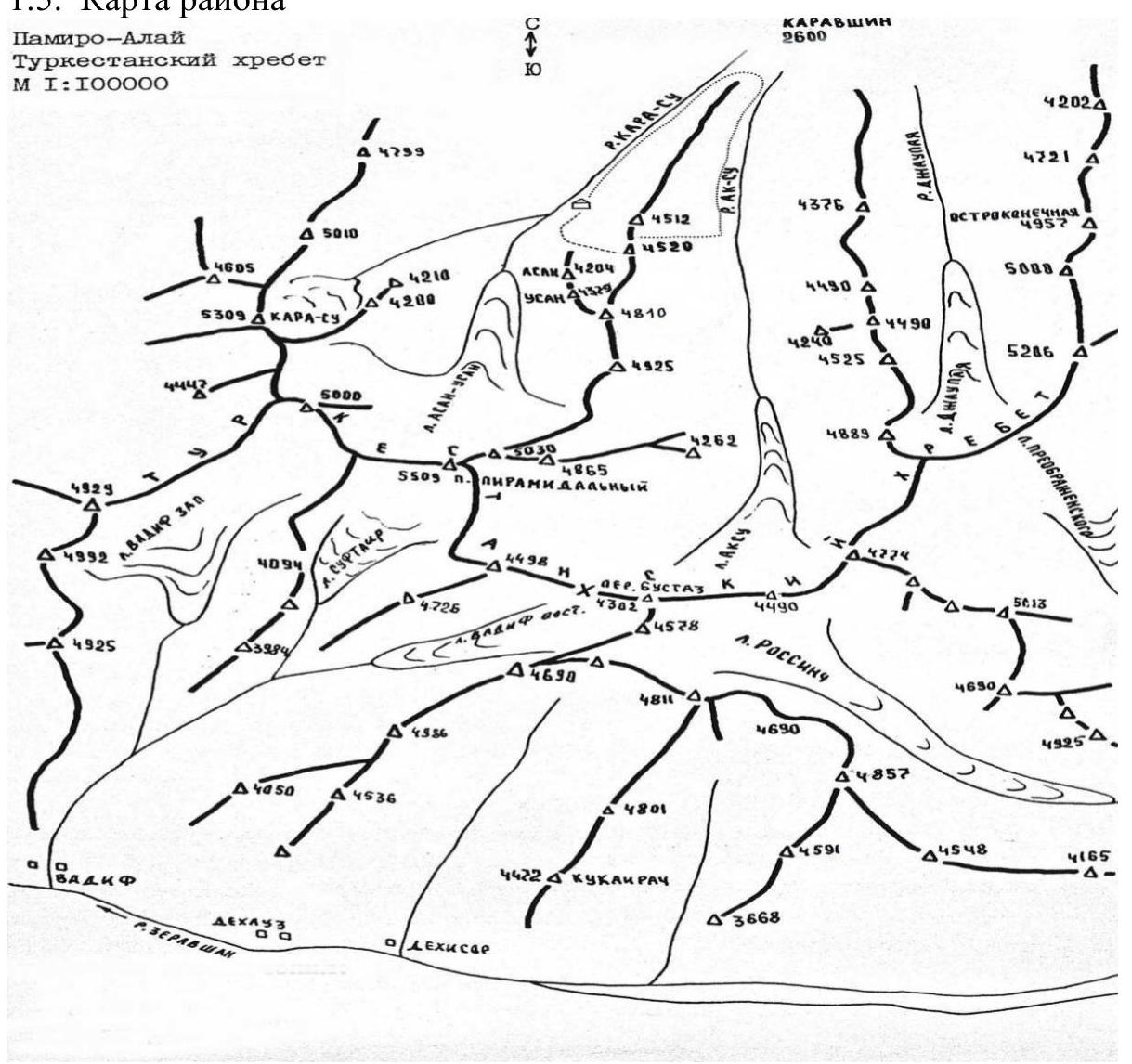
| 2.1 | Region | Pamir-Alay, Turkestan Ridge |
| 2.2 | Valley | Karavshin valley |
| 2.3 | Section number according to the 2013 Classification Table | 5.4.3.23a |
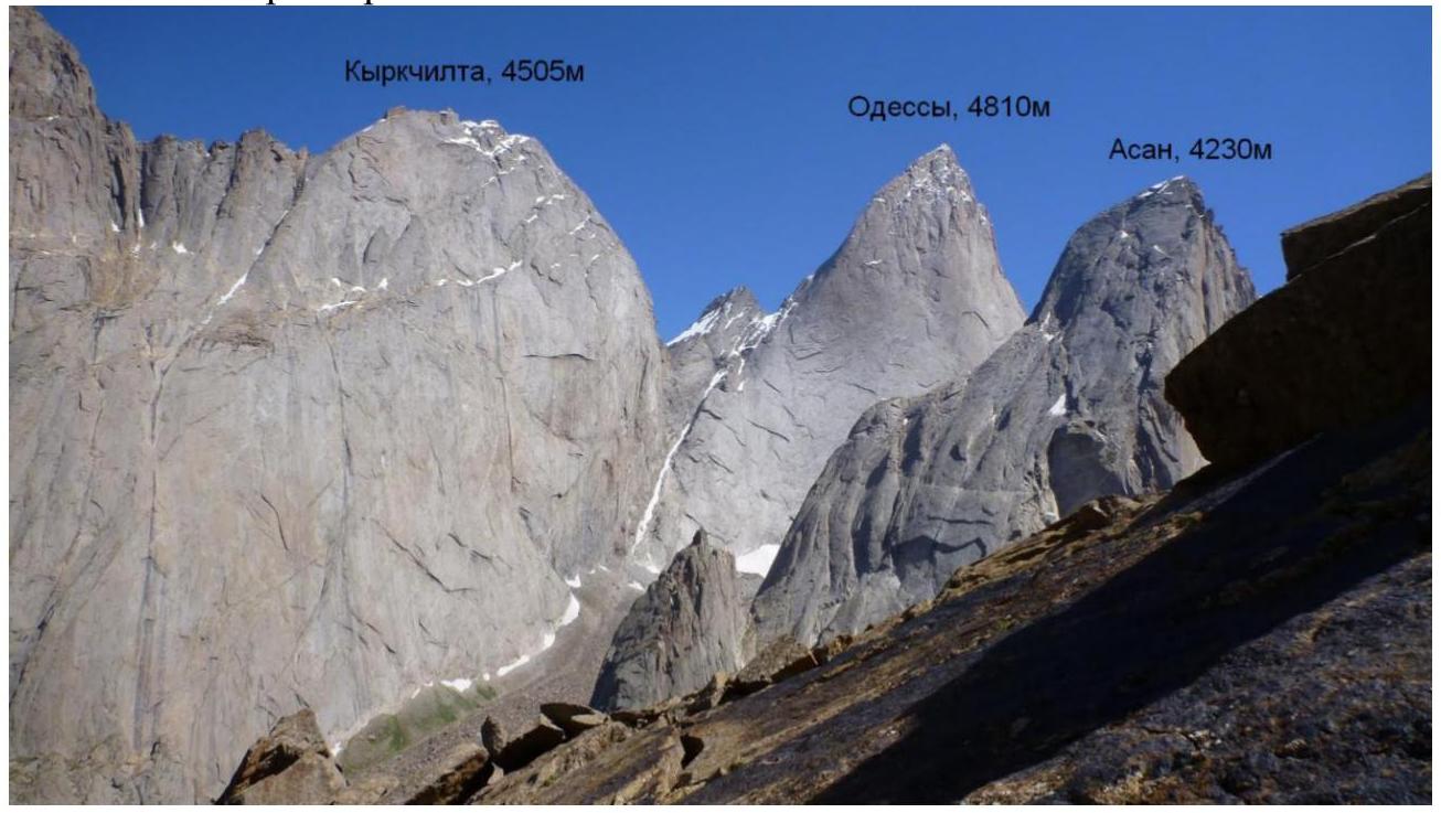
| 2.4 | Name and height of the summit | Peak Kyrkchilta, 4507 m |
| 2.5 | Geographical coordinates of the summit (latitude/longitude), GPS coordinates | |
| 3. Characteristics of the Route | ||
| 3.1 | Name of the route | via the center of the SW wall (M. Dave route) |
| 3.2 | Proposed category of difficulty | 6B |
| 3.3 | Degree of route exploration | 4th |
| 3.4 | Nature of the route terrain | Rock |
| 3.5 | Height difference of the route (altimeter or GPS data) | 1250 m |
| 3.6 | Route length (in meters) | 1755 m |
| 3.7 | Technical elements of the route (total length of sections of various difficulty categories with indication of the terrain nature (ice-snow, rock)) | 1B cat. diff. ice/rock/combination — m. 2A cat. diff. ice/rock/combination — m. 3A cat. diff. ice/rock/combination — m. 4A cat. diff. rock — 745 m. 5A cat. diff. rock — 415 m. 6A cat. diff. rock — 595 m. Rock VI, A3 — 150 m. Rock VI, A4 — 15 m |
| 3.8 | Average steepness of the route, (°)*(2) | 65° |
| 3.9 | Average steepness of the main part of the route, (°)*(2) | 70° |
| 3.10 | Descent from the summit | Via 5B category of difficulty to Ak-Su valley |
| 3.11 | Additional characteristics of the route | Snow on the big ledge |
| 4. Characteristics of the Team's Actions | ||
| 4.1 | Time of movement (climbing hours) | 31 h, 3 days |
| team's actions, indicated in hours and days) | ||
| :-- | :-- | :--: |
| 4.2 | Bivouacs | ledge |
| 4.3 | Time of route processing *(3) | 0 h, 0 days |
| 4.4 | Exit to the route | 6:30 July 23, 2018 |
| 4.5 | Summit exit | 17:30 July 25, 2018 |
| 4.6 | Return to the base camp | 1:30 July 27, 2018 |
| 5. Characteristics of Weather Conditions *(4) | ||
| 5.1 | Temperature, °C | 10 °C |
| 5.2 | Wind speed, m/s | 5 m/s |
| 5.3 | Precipitation | 0 |
| 5.4 | Visibility, m | clear |
| 6. Responsible for the Report | ||
| 6.1 | Full name, e-mail | Prokofyev D.E. desprok@gmail.com |
II. Ascent Description
1. Characteristics of the Ascent Object
1.1. General Photo of the Summit
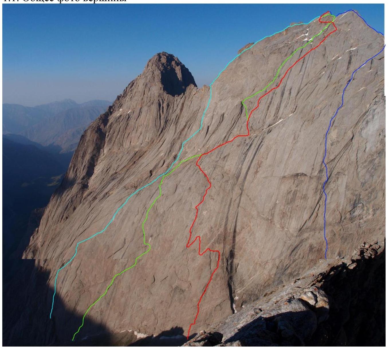
- V. Skripko's route (1988)
- A. Klepikov's route (2015)
- Route taken by the team
- V. Igolkin's route (1988)
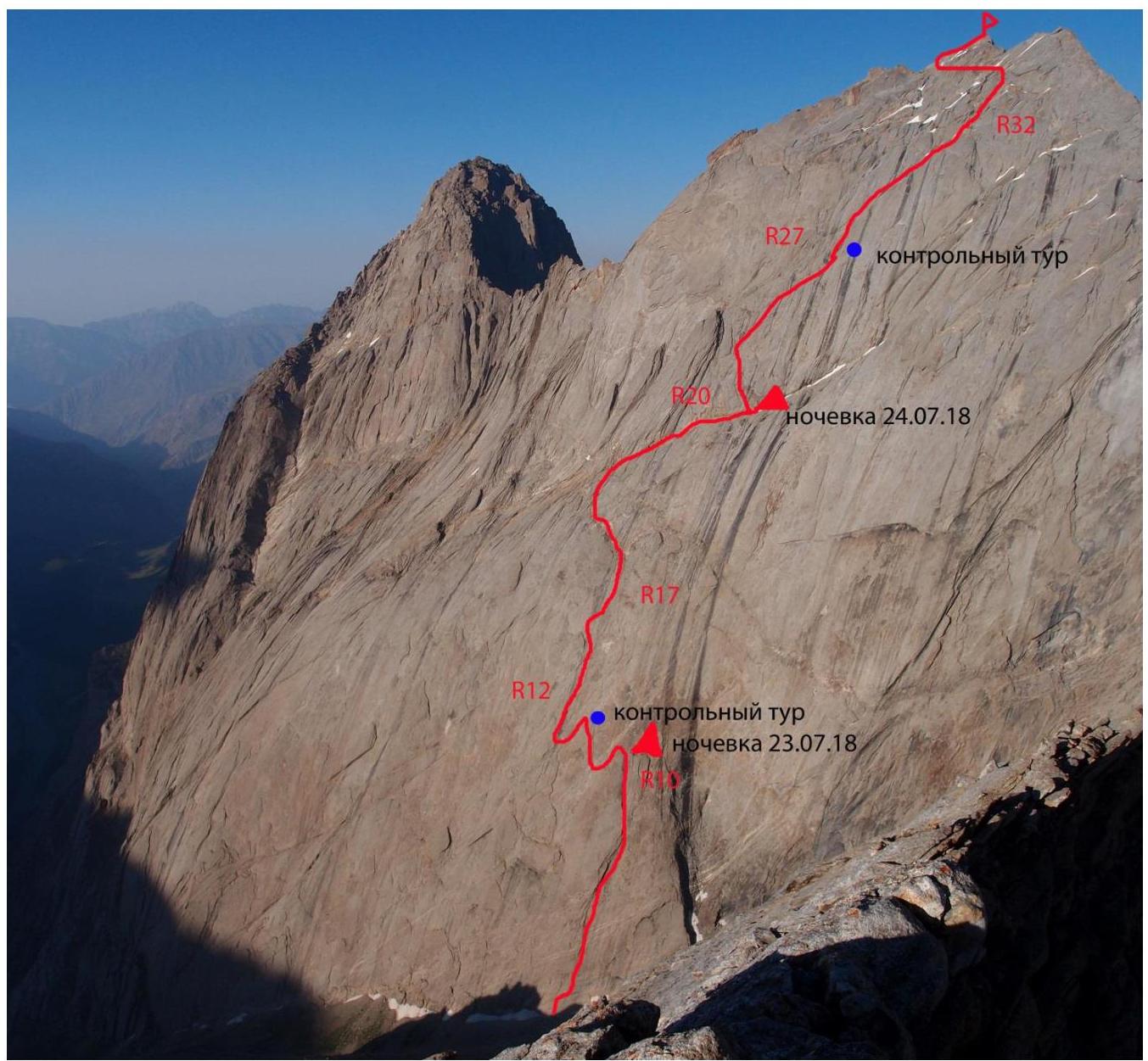
1.2. Photo of the Route Profile

1.3. Drawn Profile of the Route

1.4. Photopanorama of the Area
1.5. Map of the Area
2. Characteristics of the Route
2.1. Technical Photograph of the Route
2.3. Route Diagram in UIAA Symbols
| friends | anchor hooks | bolt hooks | sky hooks | relief/ hole | Section # | length | steepness | difficulty |
|---|---|---|---|---|---|---|---|---|
| R34 | 20 m | 45 | V | |||||
| R33 | 60 m | 45 | II | |||||
| 50 m | 50 | II | ||||||
| 60 m | 1 | |||||||
| 3 | R32 | 60 m | 50 | IV–V | ||||
| 5 | R31 | 50 m | 50 | V–VI | ||||
| 3 | R30 | 50 m | 60 | V | ||||
| 4 | R29 | 40 m | 50 | IV | ||||
| 10 m | 90 | VI | ||||||
| 2 | R28 | 50 m | 60 | IV | ||||
| 7 | R27 | 50 m | 70 | VI | ||||
| 10 | 3 | R26 | 60 m | 60 | VI | |||
| 6 | 2 | R25 | 40 m | 60 | VI | |||
| 4 | 7 | R24 | 40 m | 80 | VI, A2 | |||
| 7 | 3 | R23 | 20 m | 45 | IV | |||
| 20 m | 70 | VI | ||||||
| 8 | 2 | R22 | 40 m | 75 | VI | |||
| 3 | R21 | 20 m | 60 | V | ||||
| 3 | R20 | 200 m | 20 | II | ||||
| 2 | R19 | 50 m | 60 | IV | ||||
| R18 | 100 m | 30 | I–II | |||||
| 8 | R17 | 45 m | 65 | VI | ||||
| 8 | 5 | 4 | 1/1 | R16 | 45 m | 70 | VI, A3 | |
| 6 | 7 | 4 | 0/1 | R15 | 40 m | 70 | VI, A3e | |
| 7 | 5 | R14 | 30 m | 75 | VI, A2 | |||
| 10 | 4 | 3 | 3/1 | R13 | 50 m | 80 | VI, A3e | |
| 12 | 3 | R12 | 10 m | 75 | V | |||
| 50 m | 75 | VI, A2 | ||||||
| 10 | 4 | 0/1 | R11 | 50 m | 80 | VI, A2 | ||
| 10 m | 60 | V | ||||||
| 1 | R10 | 10 m | 70 | V | ||||
| 8 | 3 | R9 | 30 m | 70 | VI, A2 | |||
| 10 | R8 | 30 m | 70 | VI, A2 | ||||
| 8 | 5 | R7 | 40 m | 60 | VI, A2 | |||
| 9 | 3 | R6 | 30 m | 70 | VI, A2 | |||
| 11 | 5 | R5 | 50 m | 70 | VI, A2 | |||
| 8 | 2 | R4 | 40 m | 65 | V | |||
| 10 | 3 | R3 | 50 m | 70 | VI, A1–A2 | |||
| 5 | 3 | 4 | 0/4 | R2 | 30 m | 75 | VI, A3 | |
| 2 | 4 | 2 | 0/1 | R1 | 30 m | 65 | VI, A3 |
- Peak Kyrkchilta, 4507 m
- Via the center of the SW wall, 6B category of difficulty
- On the ledge, second control tour
- Bivouac: on the ledge, reclining
- On the ledge, first control tour
3. Characteristics of the Team's Actions
3.1. Brief Description of the Route Ascent
- The team arrived in the area on July 18, 2018.
- On July 19, 2018, they made an acclimatization exit to the area of peak Sibirsky.
- Acclimatization bivouac at 3900 m on July 20, 2018.
- They ascended to a height of 4800 m, then descended to the camp.
- Rest day.
During the acclimatization exit, they considered several options for ascents.
As a result, they chose peak Kyrkchilta (4507 m) and the route via the center of the SW wall, 6B category of difficulty (M. Dave's route), as a modern route with few repetitions.
They adopted a "no-platform" tactic for the ascent, as there were several ledges for bivouacking, including one with snow in the upper part of the route. However, the location of the ledges required the team to demonstrate maximum speed in climbing and technical work.
The weather in the area was unique: sunny and warm. The night temperature did not drop below 0 °C. The forecast was favorable for the next five days, after which a sharp temperature drop with significant precipitation was predicted. Such a long weather window is rare in this area.
Based on this, they decided to climb the route immediately, without warming up on simpler routes.
They adopted a simultaneous protection movement tactic, allowing the second and third team members to quickly pass sections of difficult terrain, constantly moving with cowtails and not delaying the leader. Each day, a new team member led, allowing for optimal force distribution and fast route completion.
In total, the ascent took 31 hours — three days (July 23–25, 2018) to reach the summit. Without prior route processing. Thus, their mixed team of three completed the fastest ascent of this route.
They took:
- three ropes;
- two sets of cams;
- 15 anchor hooks;
- 15 quickdraws, anchor slings;
- a bolt kit;
- bivouac gear: tent, two mats, two sleeping bags, "Jetboil" stove, two gas canisters.
The team had 10 liters of water, calculated at 2 liters per person per day. They noted that a small snowpatch was visible on the second ledge, promising water replenishment at the end of the second day of ascent.
On July 22, 2018, after a rest day, the team moved to the approach and bivouacked under the route on the moraine in the northwest cirque under the wall of peak 4810 m.
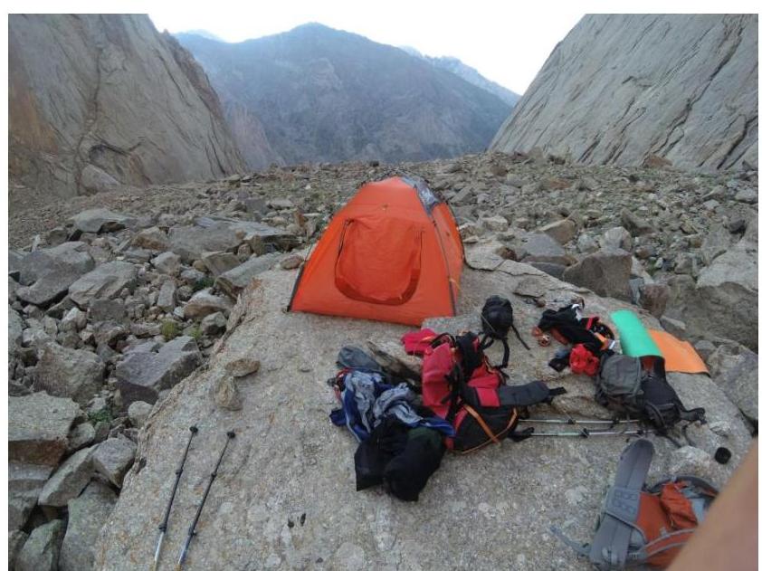
Fig. 1. Bivouac under the wall of Kyrkchilta
On July 23, 2018, at 6:30, the team started on the 6B Dave route without prior processing and pre-pitching. The first day, Prokofyev D.E. led. Sections R0–R11 were completed.
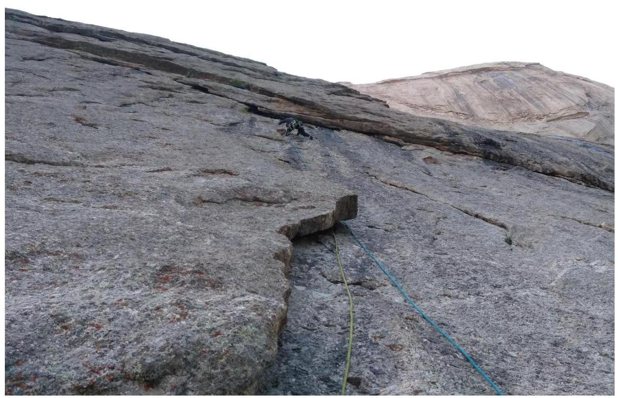
Fig. 2. Section R1–R2. Leader's approach to the second cornice.
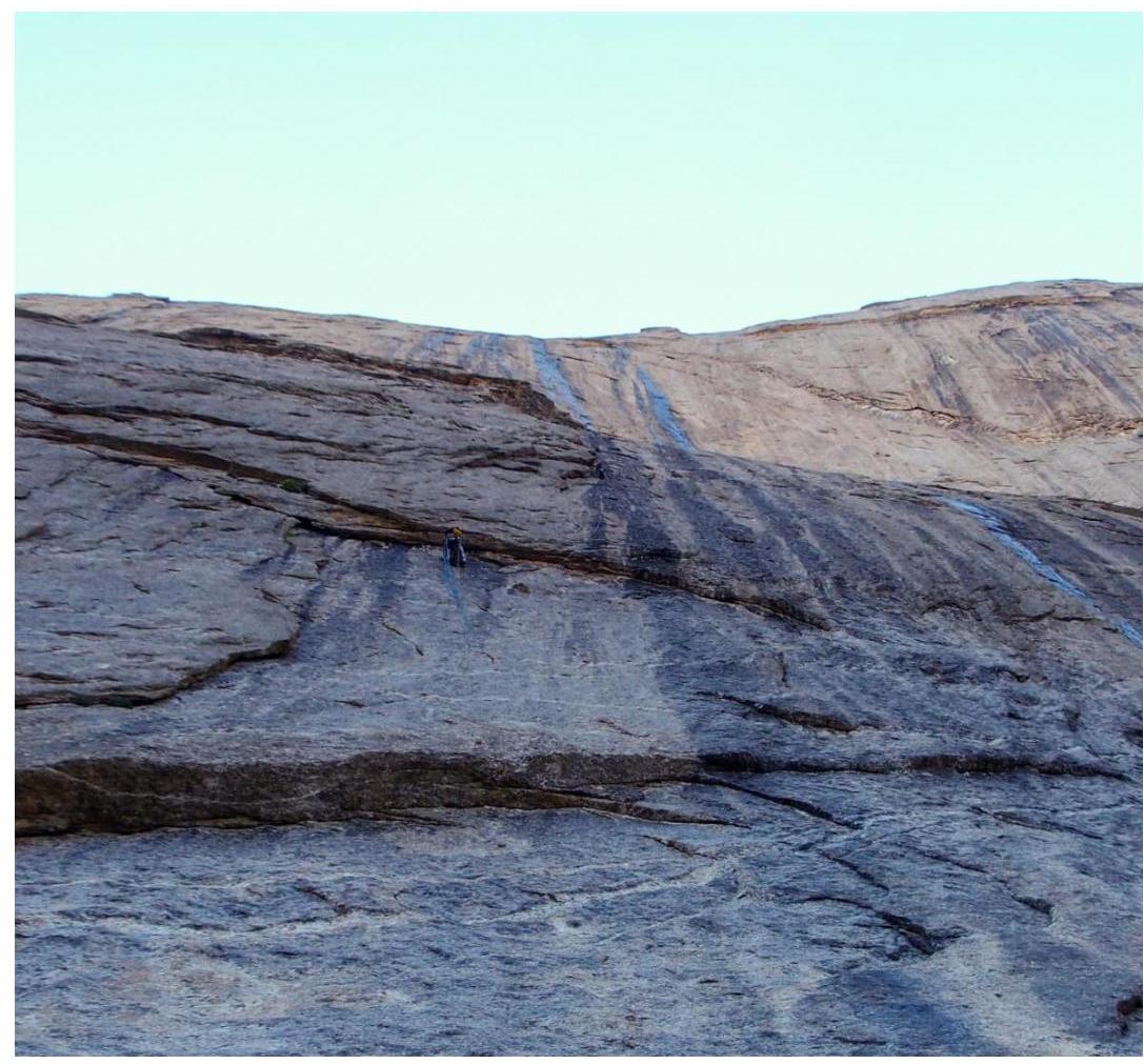
Fig. 3. Section R2–R3. Exit from the cornice, traverse by M. Popova, leader above on section R3, taken from R0.
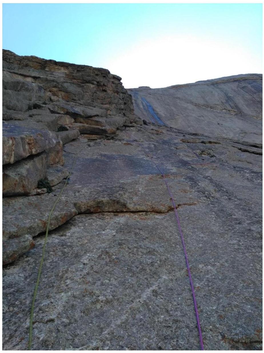
Fig. 4. Section R4–R5. Taken from the station. D. Prokofyev leads.
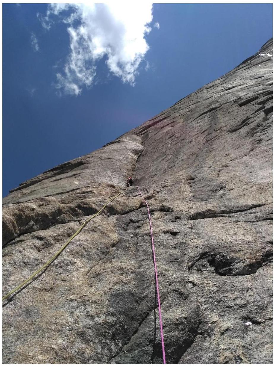
Fig. 5. Leader at the start of the vertical inner corner R8–R9. The corner is passed with ITO and complex climbing (the crack widens, making protection organization challenging).
Further, they reached a good ledge for a bivouac for 2–3 people. They set up a bivouac on it, at R10.
Above the bivouac, they passed two sections, R11 and R12.
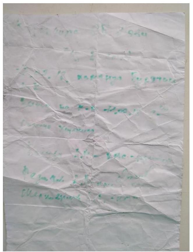
Fig. 6. On R11, they found the first control tour and retrieved a note from the Buryatia team dated July 12, 2018. The note is in poor condition but readable.
The comfortable ledge allowed the team to rest well and recover. They continued the ascent on July 24, 2018, at 8:00.
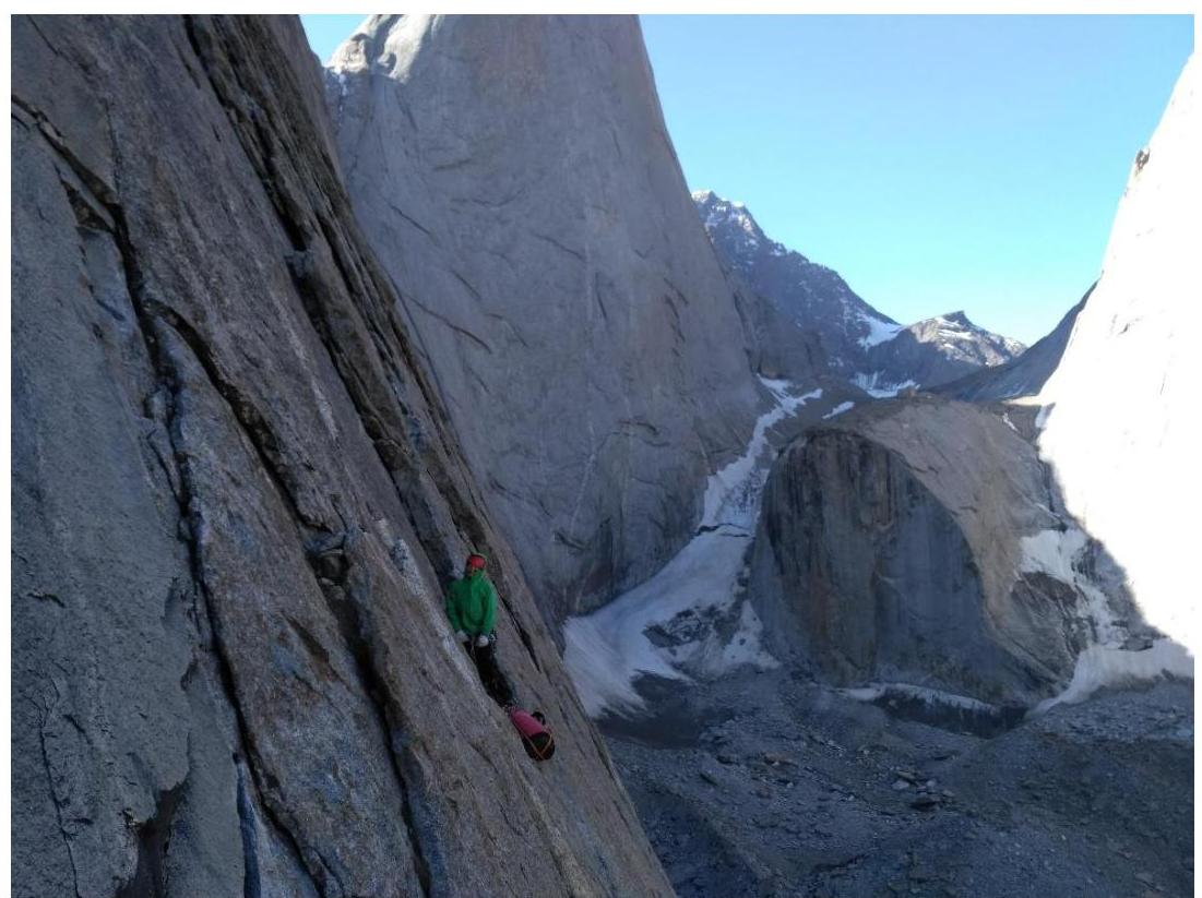
Fig. 7. D. Prokofyev works as third, after the second rappel, stands on R10, after rappel from the first control tour.
The second day (July 24, 2018), Polunin V.L. led. The ascent on the first and second days was complicated by difficulty in orientation on sections R0–R2 and R13–R17 due to the lack of stationary bolt anchors on sections without visible relief. The first ascenders used only removable protection.
On these sections, the leaders had to apply all their rock climbing skills to pass these sections with free climbing and minimal protection on natural features.
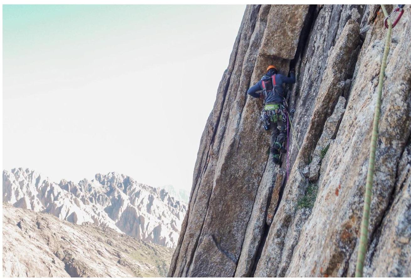
Fig. 8. R11–R12, Polunin V.L. leads.
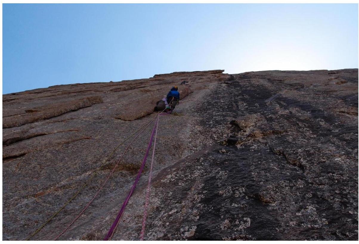
Fig. 9. R12–R13. Polunin V.L. leads. Popova M.E. on protection.
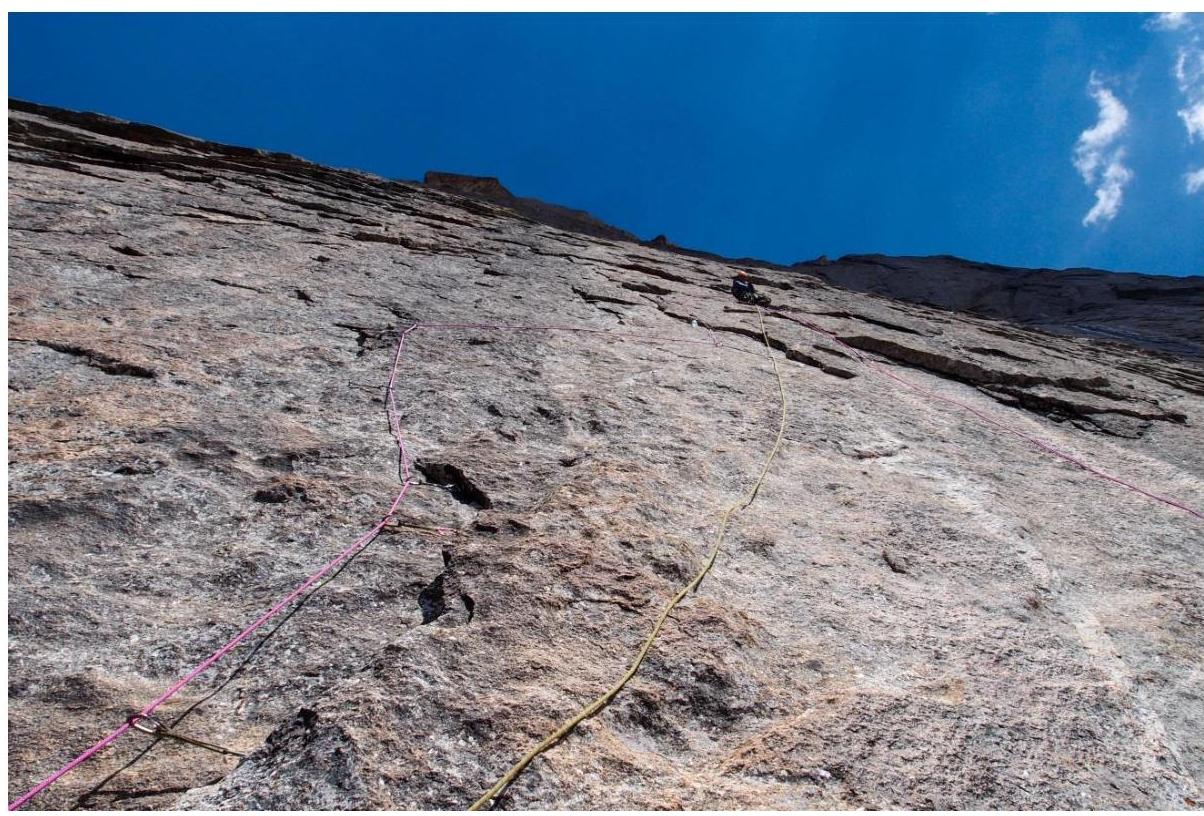
Fig. 10. R14–R15, one of the key sections of the route.
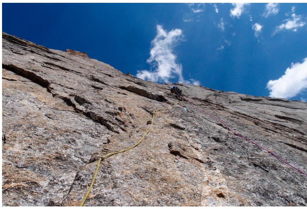
Fig. 11. R16–R17, Vladislav Polunin works on the key part.
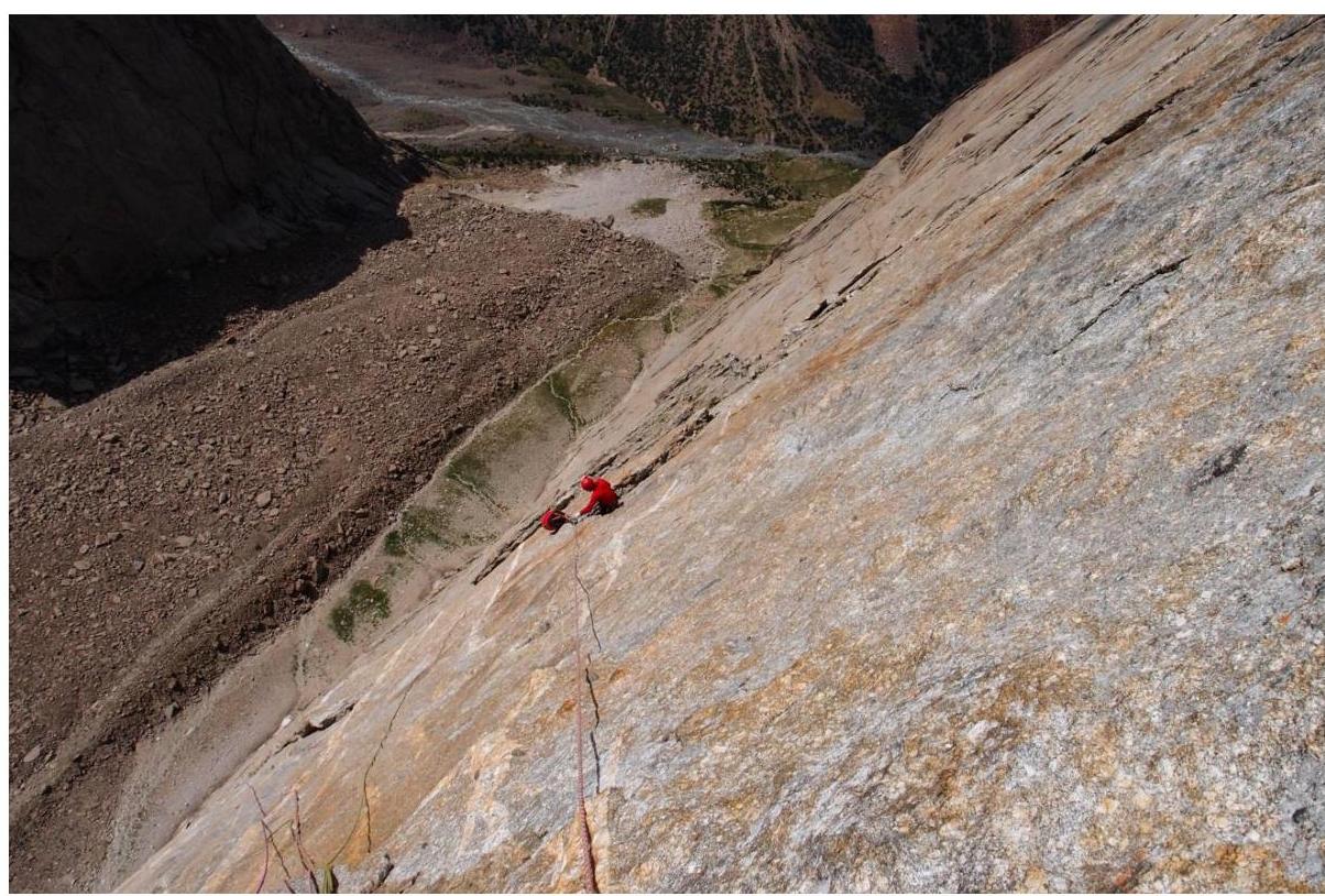
Fig. 12. Prokofyev D.E. works with a cowtail.
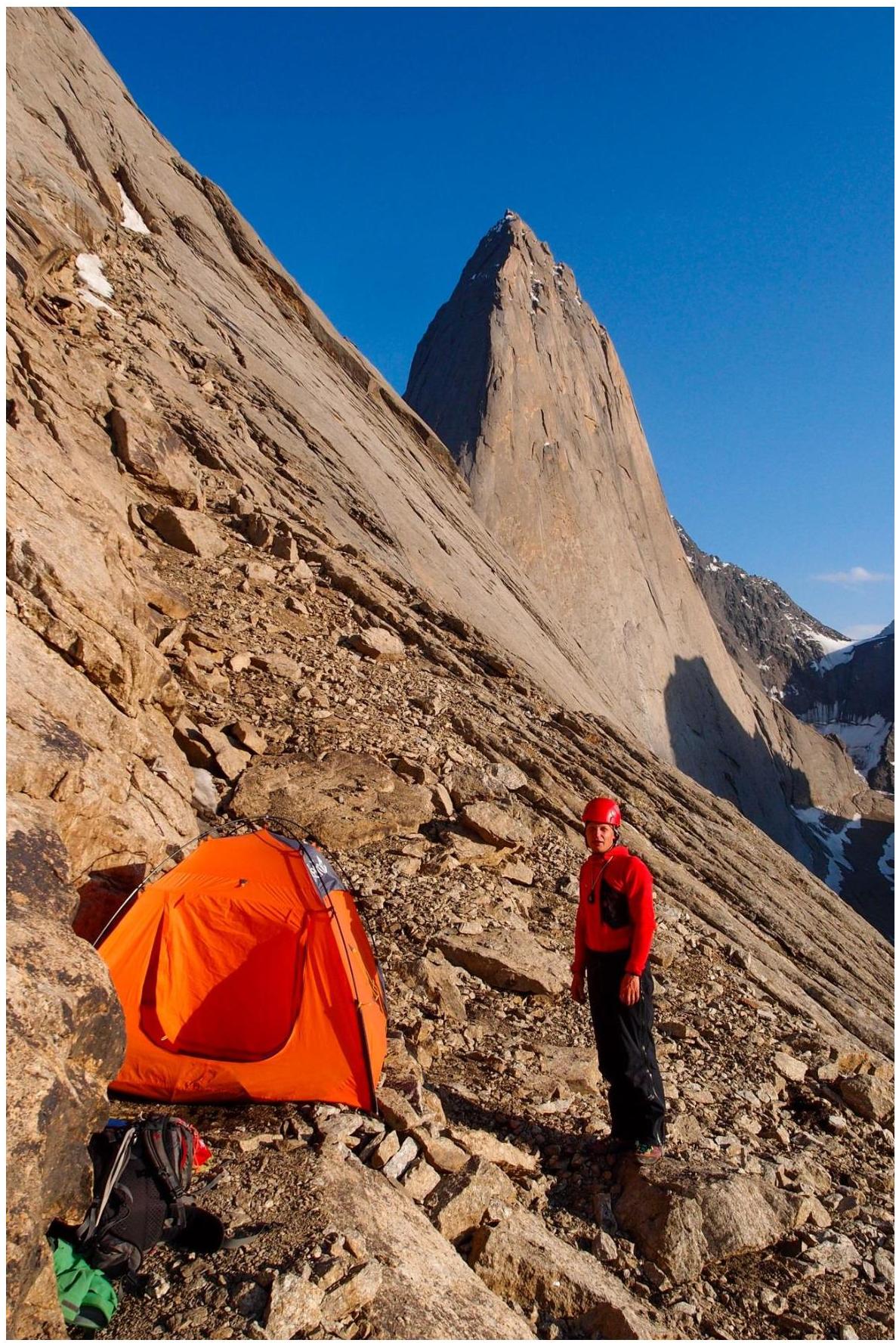
Fig. 13. On R20, bivouac at the base of the second bastion. Second bivouac on the route.
As a result, on the second day of ascent, the team reached section R20 at the base of the second bastion and set up a bivouac on a comfortable ledge with a snowpatch. They expanded the bivouac site to a comfortable size and replenished their water supply.
On July 25, 2018 (third day of ascent), Popova M.E. led. That day, they managed to pass the second bastion completely and gain the last 500 m in height to the summit, R20–R34.
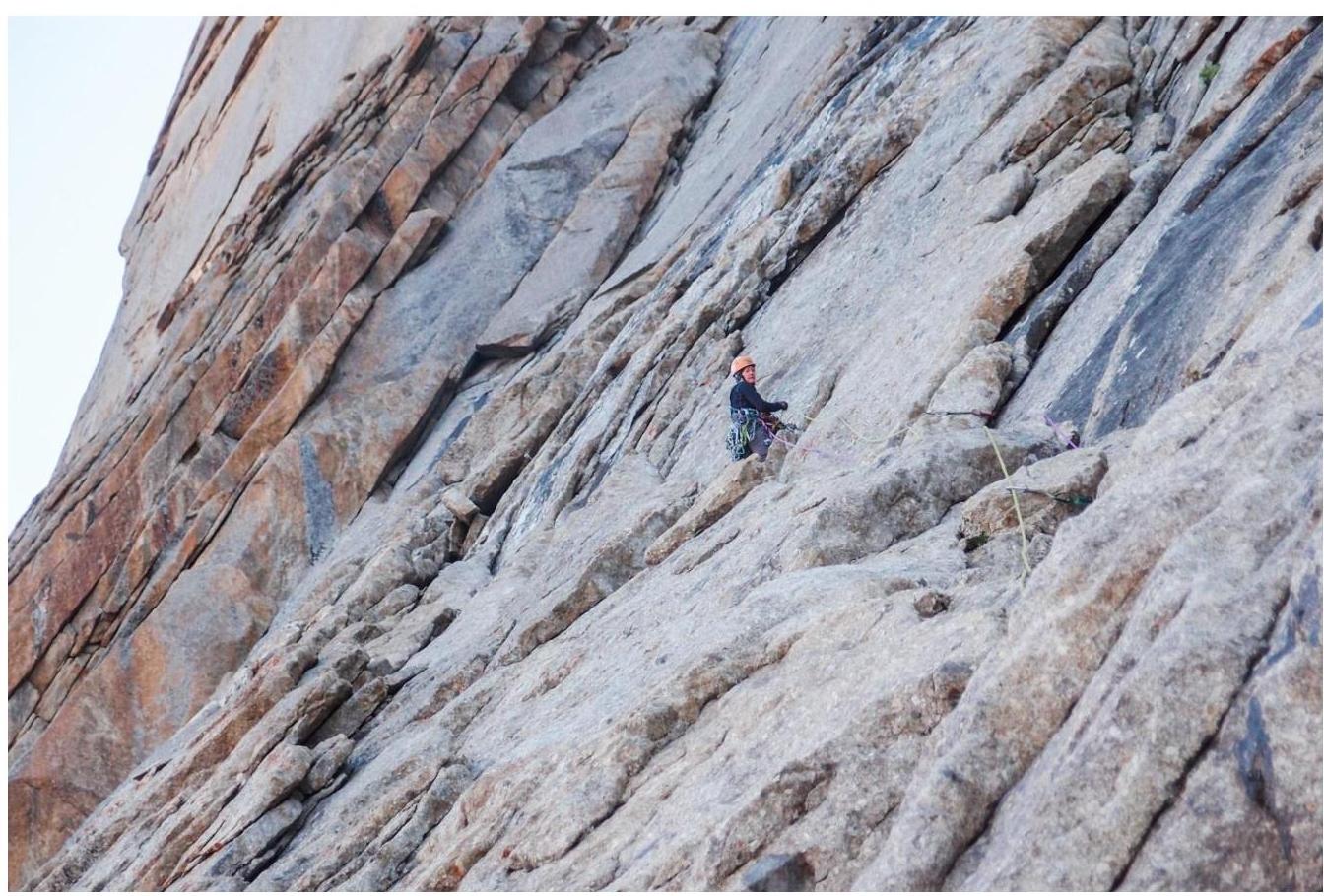
Fig. 14. R20–R21, Popova M.E. leads. The second bastion is climbed entirely via logical relief, but the leader must constantly orient and compare with the description to follow the route line and reach the summit optimally.
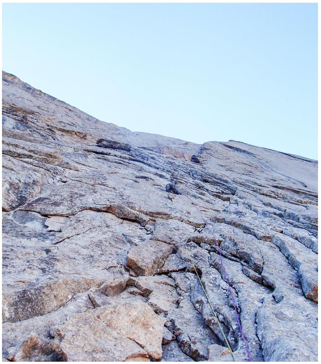
Fig. 15. R21–R22. Climbing on flakes.

Fig. 16. R22–R23. Water flows on the rocks.
The leader performed as an excellent rock climber, passing complex sections with maximum use of free climbing, except for a few steps on ITO in places where water flowed heavily on the wall.
On section R27, they found the second control tour and retrieved a note from the first ascenders, M. Dave and A. Cheremnykh, indicating the correct passage of the route line. No other group's notes were found in the tour.
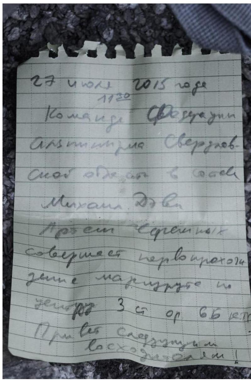
Fig. 17. R27 — note from the control tour.
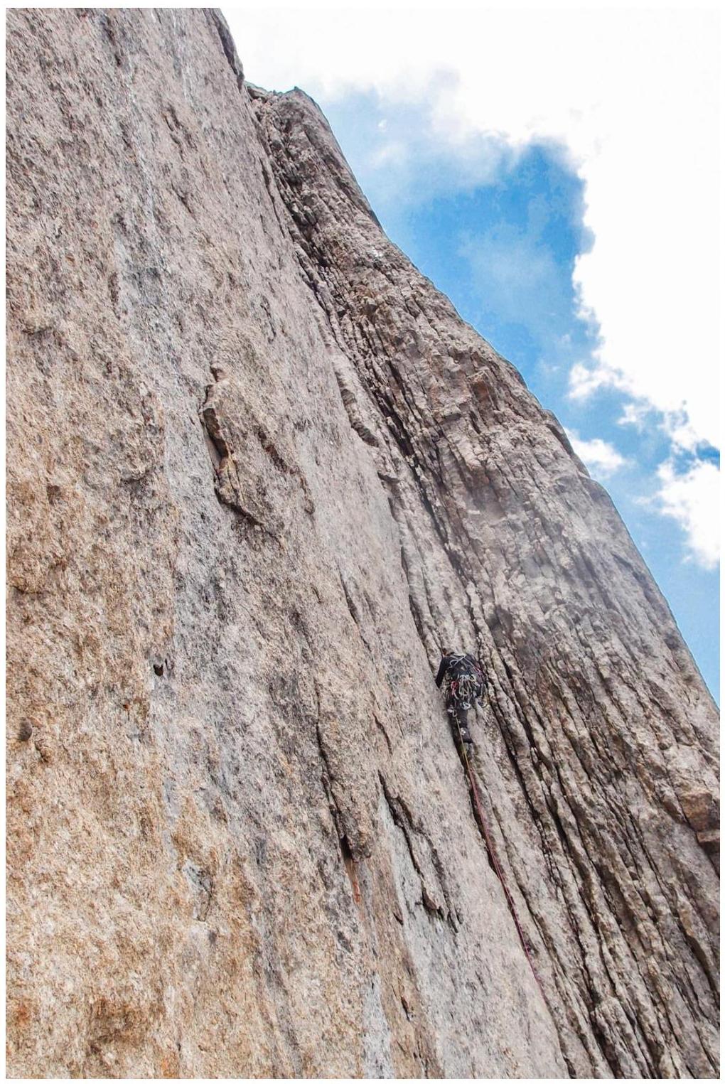
Fig. 18. R26–R27. Popova M.E. leads, moving up the corner.
On July 25, 2018, at 17:30, the team reached the summit of peak Kyrkchilta in full.
Since the descent was expected to be long, they decided to bivouac on a ledge near the summit and start the descent early in the morning.
| Section # | Description | Photo # |
|---|---|---|
| R0–R1 | Smooth slab with a cornice, transitioning into a crack. On the cornice, a hole for a skyhook. Further — climbing. | 2 |
| R1–R2 | Crack, abuts a cornice. Under the cornice, a 10 m traverse to the right, then free climbing to a system of deep cracks. Station on a small ledge. Climbing is extremely difficult, protection is very unreliable. Approximately 6c–6c+. | 2 |
| R2–R3 | Through a small wall into a global flake. Water flows through the flake. Complex climbing with transitions to ITO. | 3 |
| R3–R6 | Further up the flake. Complex climbing with transitions to ITO. | 4 |
| R6–R7 | Movement up via slabs and inner corners. | |
| R7–R9 | Entering a large vertical inner corner, complex climbing with ITO. Exiting onto a large ledge. Bivouac on the large ledge. | 5 |
| R9–R10 | To the left, through a small wall (10 m). Further, a rappel to the left, to the next global flake. | 6, 7 |
| R10–R11 | Up the flake for 60 m, exiting onto a ledge. On the ledge, a control tour on a bolt hook, from which a rappel is organized to the left, down to the next flake. | |
| R11–R12 | Traverse 10 m to the flake, then up the flake. Complex climbing with transitions to ITO. | 8 |
| R12–R13 | System of interrupted deep cracks, passed on ITO with transitions to extremely complex climbing. Several pendulum swings from one crack to another. In the upper part | 9 |
| several moves on relief skyhooks. Section of extreme difficulty. | ||
| R13–R14 | Up the crack, exiting onto a ledge. In the lower part — ITO, in the upper part — climbing. | |
| R14–R16 | From the ledge, via a system of deep cracks, to the right and up. Very complex climbing on balance. местами ITO, pendulum swings from one crack to another. Very poor protection. | 10, 11, 12 |
| R16–R17 | Via a crack, traversing to the right, exiting onto a quartz "vein". Along the "vein", to the left and up, under a cornice. Exiting onto the first global terrace. | |
| R17–R18 | Along the terrace, 100 m of simple rocks to the left and up. | |
| R18–R19 | Simple climbing straight up, exiting onto the second global terrace. | |
| R19–R20 | Along the terrace, 200 m of simple rocks to the right and up. Bivouac on the terrace. | 13 |
| R20–R21 | Short section up a crack onto a small ledge. | 14 |
| R21–R22 | Up the crack, to a flake hanging on one side. Exiting onto a ledge through the flake. | 15 |
| R22–R23 | Traverse towards the next flake. Further up the flake, complex climbing on crumbly rock. | 16 |
| R23–R25 | Up the flake hanging on one side, complex climbing on crumbly rock. Exiting onto a ledge. | 11 |
| R25–R26 | Along the ledge, slightly to the right, then up a wall, and 40 m to the right and up a crack towards a large inner corner. Exiting onto a ledge via the inner corner. Here, the second control tour and a convenient spot for a possible bivouac. | 17 |
| R26–R27 | From the ledge, up the inner corner. | 18 |
| R27–R29 | To the right and up, towards a large cornice. The cornice is climbed from the right. | |
| R29–R32 | To the right and up, towards the right vernal gendarme. | |
| R32–R34 | Without reaching the gendarme, traverse with descent to the left, via simple slabs — exit to the ridge, to the left of the summit. | |
| R34 | Along the ridge to the summit — 20 m to the right. | 19, 20 |
3.2. Photo of the Team on the Summit at the Control Tour

Fig. 19. Photo from the summit, peak 4810 m in the background.
They retrieved a note from the Buryatia team on the summit.
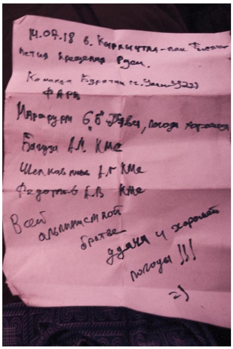
Fig. 20. Note from the summit.
The descent began via the French Edge at 8:00. The team made 22 rappels and reached the ground in Ak-Su valley by 18:00. Further descent was along grassy slopes to the Ak-Su river, where they encountered another rappel on rocks.
The descent is safe, with many ready-made stations. It's always necessary to stay to the right and not rush down the line of water flow, as this can increase the descent time to 40 rappels. The main landmark is the huge gendarme at the foot of the mountains, which separates the Kyrkchilta and Koting (Shaytankhan) peaks.
On the day of descent, the weather began to deteriorate, with rain starting at 16:00, and all peaks were shrouded in dense fog. It then cooled down, and rain continued for several days. Ascending this route with the same speed would have been impossible in the following 10 days (while the team was in the area) due to low temperatures and significant precipitation. Thus, the team correctly calculated the days and ascent speed.
At 1:30 on July 27, 2018, the group returned to the camp in Karasu valley. Overall, the Dave route, 6B category, is a modern sixth category route that requires all skills in both technical and rock climbing preparation. The route is not easy for the leader, second, or third, as it involves many traverses and pendulum swings.
The route is safe. There is constant communication with the camp in Karasu valley. Communication with Karasu valley is lost on the descent to Ak-Su valley.