Climbing Report on the First Ascent
As part of the Russian Climbing Championship by Correspondence. High-Altitude Technical Class
Peak 1000 let Kreshcheniya Rusii (Kyrkchilta) (4507 m) via the center of the Southwest wall. Route category 6B (proposed), first ascent.
- Pamiro-Alay (5.4.3). Karavshin valley
Team Leader: A.A. Klepikov (Master of Sports) Team Members: S.A. Lazarev (1st sports category), I.V. Likhonosov (1st sports category)
Ascent Passport
1.5. Pamiro-Alay. Karavshin valley 5.4.3. 2. Peak 1000 let Kreshcheniya Rusii (Kyrkchilta) (4507 m), center of the Southwest wall. 3. Proposed category 6B – first passage. 4. Route type: rock climbing. 5. Route height difference: 1300 m
Route length: 2260 m Main part height difference: 1120 m Main part length: 1930 m Section length V–VI: 1422 m, including:
- V category: 1010 m
- VI category: 412 m
Average steepness of the main part: 71° Average steepness of the entire route: 67°
- Hooks left on the route: total: 3; including bolted: 3 Used on the route:
- bolted hooks – 7, including removable – 4
- rock hooks (including anchors) – 154
- chocks – 8
- friends – 178
- skyhooks (including passages on fiffs) – 7
Total number of Intermediate Technical Obstacles (ITO): 12
- Team's total climbing hours (to the summit): 40; days: 4
Number of bivouacs on the route: 3, on the summit: 1.
- Team Leader: Alexander Alexandrovich Klepikov (Master of Sports) – trainee instructor Team Members:
- Stanislav Alexandrovich Lazarev (1st sports category)
- Igor Vladimirovich Likhonosov (1st sports category)
- Team Coach (Klepikov's): Andrey Evgenievich Afanasyev (Master of Sports), 1st category instructor
- Route start: 9:00, July 8, 2015
Summit arrival: 17:00, July 11, 2015 Return to Base Camp: 23:00, July 12, 2015
- Report responsible: Klepikov A.A. Baikalteam@gmail.com Phone: +7 950 089-17-08
Photo of the general view of the Southwest wall of peak Kyrkchilta (4507 m)
Photo taken from peak Asan 4230 m. Distance 2 km.
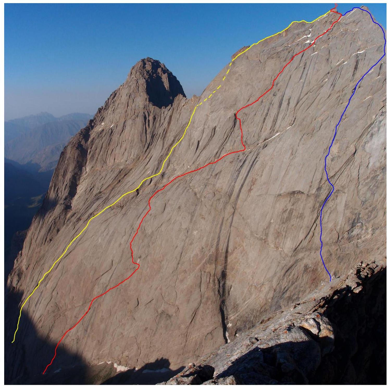
Routes:
- YELLOW – Skripko's route, 1988, 6A category
- RED – Team's route, 6B category
- BLUE – Igolkin's route, 1988, 6A category
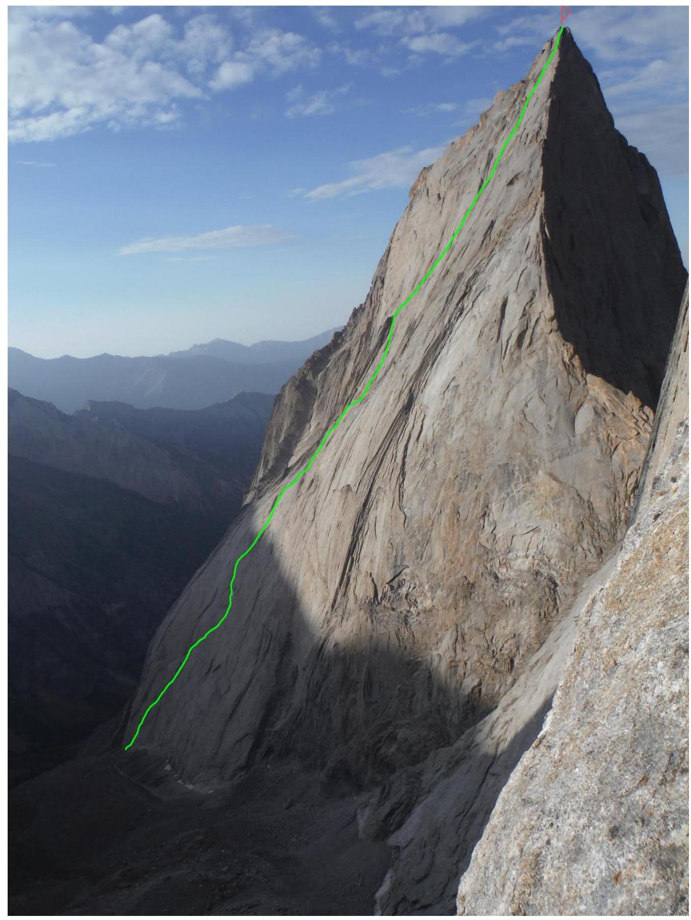
Photo of the route profile from the right, semi-profile
Photo taken during the ascent of route 6B on the Central Northwest wall of peak Odessa 4810, approximate camera height 4200 m above sea level. Date: July 26, 2015
Drawn profile of the route

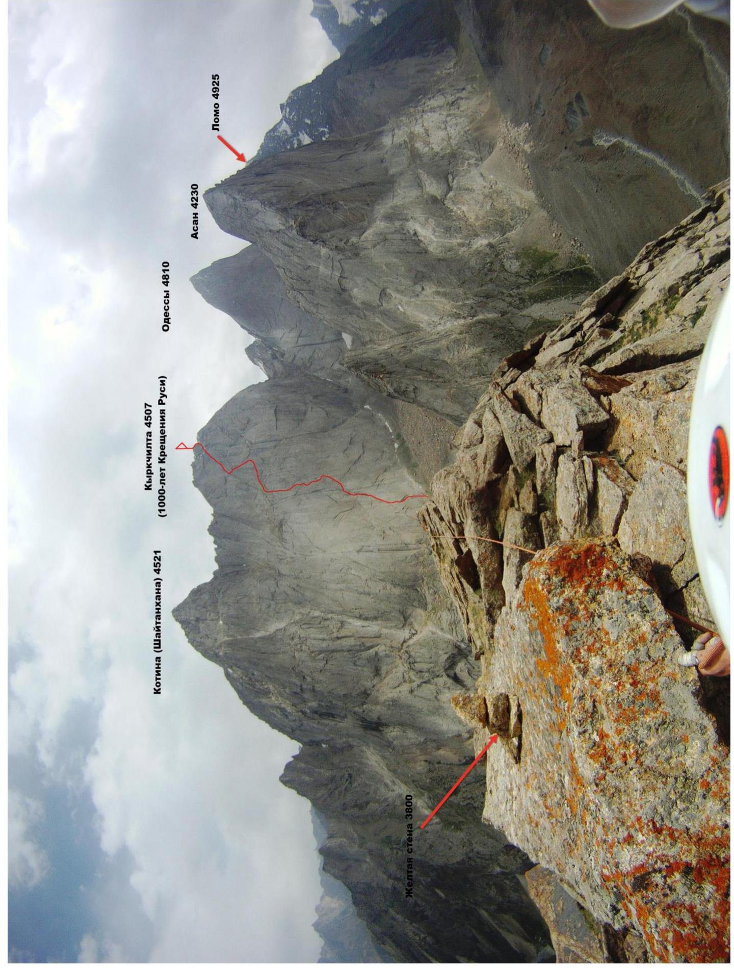
Panorama of the peaks in the Kara Su valley
Photo taken from peak Yellow Wall 3800 m.
The Karavshin valley is considered the "Mecca" of modern Russian technical mountaineering, and rightfully so. Currently, there are:
- 8 classified 6B routes;
- about 30 routes of 6A category.
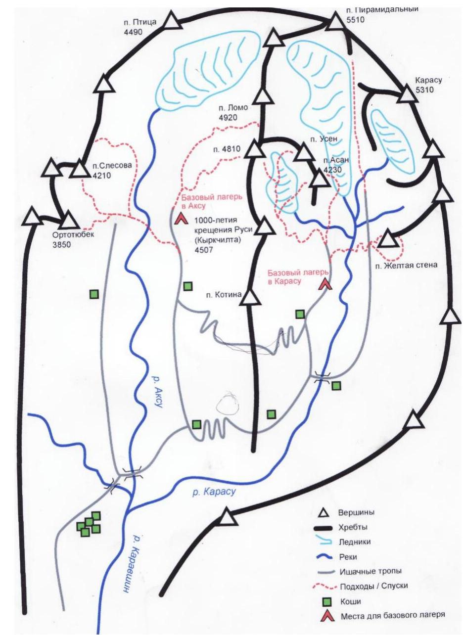
Peak 1000 let Kreshcheniya Rusii (Kyrkchilta) (4507 m) is located in the same ridge as peaks:
- Kotina (4521 m)
- Odessa (4810 m)
- Lomon (4925 m)
This ridge separates the Kara Su and Ak Su valleys. The nearest large settlement is Batken town. There are four options to get to Karavshin from Batken:
- Helicopter transfer directly from Batken;
- Via Vorukh village (Tajik enclave) – 1.5 days;
- Via Sari-Az village – 2 days;
- Via Uz Guruh village – 3 days.
The final choice depends on the local political situation, trail conditions, etc.
There are only two routes on the Southwest wall of peak Kyrkchilta, both 6A category, both climbed in 1988. Moreover, the descriptions incorrectly refer to it as the Northwest wall.
- The left route is Skripko's route, 6A, which is the first ascent route.
- The right route is Igolkin's route, 6A, a steeper and shorter line.
The center of the wall has not been climbed before, although attempts were made, as evidenced by the presence of old gear. Gear from different times was found up to the eighth rope, with some having rappel rings.
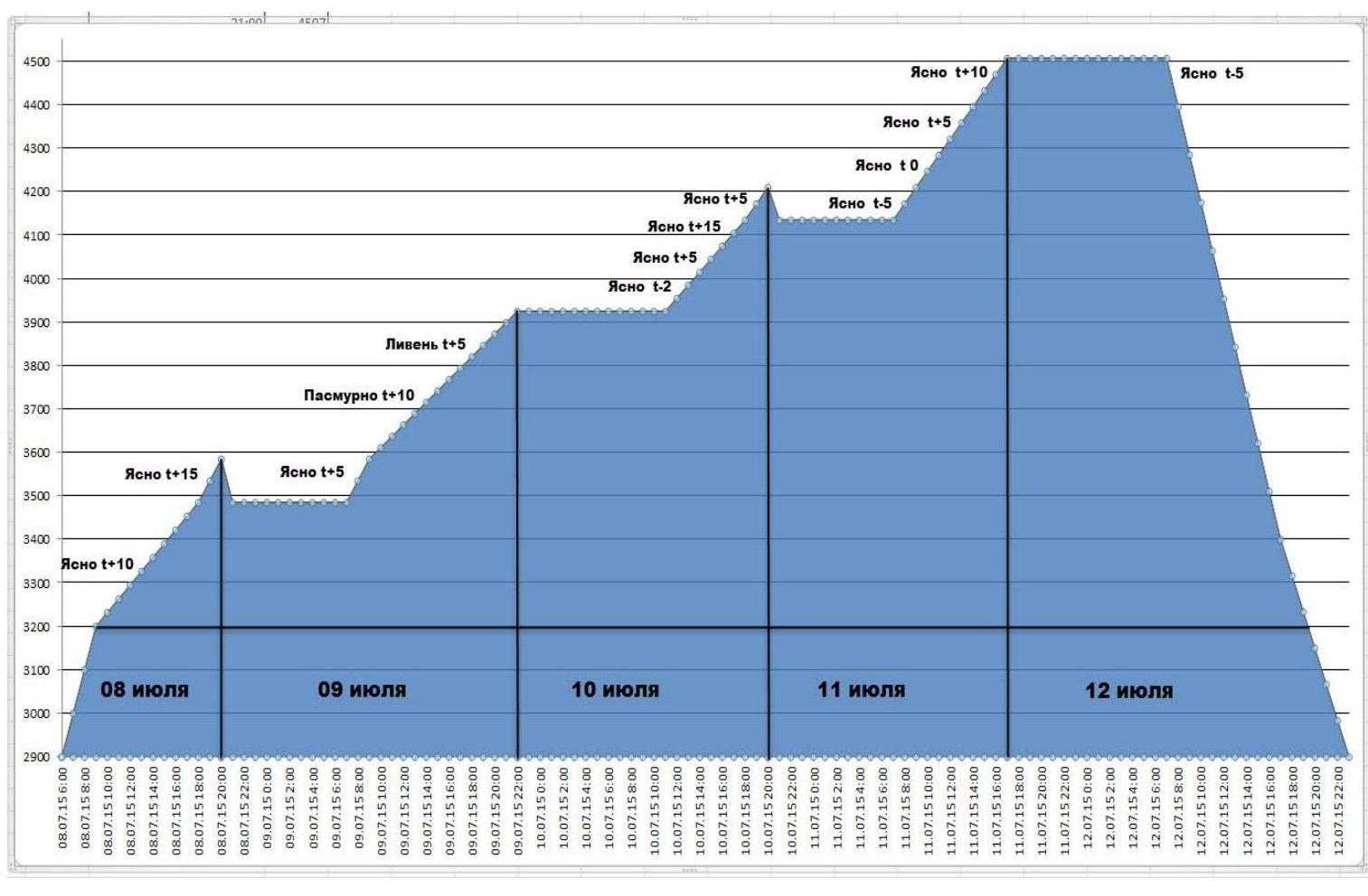
Team's movement graph on the route
- July 8, 2015 — from 9:00 to 20:00, sections R0–R23 were completed, overnight stay three ropes below at point R15, a safe location protected by a slightly overhanging wall.
- July 9, 2015 — from 9:00 to 21:30, sections R23–R43 were completed, overnight stay 50 m to the left of point R43, on a bastion-protected platform from falling rocks.
- July 10, 2015 — from 12:00 to 20:00, sections R43–R61 were completed, overnight stay at point R53, on an "ogurtsa" (cucumber-shaped ledge).
- July 11, 2015 — from 8:30 to 17:00, sections R61–R83 were completed, reaching the summit.
- July 12, 2015 — from 7:00 to 23:00, descent to Base Camp via the "French Edge" route. 31 rappels.
Diagram of the main part of the route in UIAA symbols, scale 1:2000, sheet 1
| Section | Chock | Friend | Rock Hook | Sky Hook Fiffs | Bolt | Diagram of the route in UIAA symbols M 1:2000 Sheet 1 | Length (m) | Steepness (gr) | Climbing grade | ITO |
|---|---|---|---|---|---|---|---|---|---|---|
| R18–R19 | - | 4 | 2 | - | - | 25 | 80 | 6- | - | |
| R17–R18 | - | 1 | 1 | - | - | 70 | 4+ | - | ||
| R16–R17 | - | - | 3 | - | - | 15 | 70 | 6- | - | |
| R15–R16 | - | 3 | 3 | - | - | 30 | 75 | 5+ | - | |
| R14–R15 | - | 1 | 1 | - | 2 | 25 | 65 | 5- | - | |
| R13–R14 | - | 2 | 1 | - | - | 25 | 75 | 6- | - | |
| R12–R13 | 1 | 3 | 2 | - | - | 20 | 75 | 5+ | - | |
| R11–R12 | - | 3 | 4 | - | - | 40 | 65 | 5- | - | |
| R10–R11 | - | 4 | 2 | - | - | 60 | 60 | 5- | - | |
| R9–R10 | 1 | 2 | 3 | - | - | 60 | 55 | 4+ | - | |
| R8–R9 | - | 1 | 1 | - | - | 30 | 75 | 5- | - | |
| R7–R8 | - | 2 | 1 | - | - | 10 | 80 | 5- | - | |
| R6–R7 | - | - | - | - | - | 10 | 55 | 2+ | - | |
| R5–R6 | - | 3 | 3 | - | - | 30 | 80 | 5+ | - | |
| R4–R5 | - | 2 | 4 | - | - | 34 | 75 | 5+ | - | |
| R3–R4 | 1 | 3 | 2 | - | - | 20 | 75 | 5+ | - | |
| R2–R3 | - | - | - | - | - | 15 | 65 | 2+ | - | |
| R1–R2 | - | 3 | 2 | - | - | 25 | 75 | 5- | - | |
| R0–R1 | - | - | - | - | - | 10 | 55 | 2- | - |
Diagram of the main part of the route in UIAA symbols, scale 1:2000, sheet 2
| Section | Chock | Friend | Rock Hook | Sky Hook Fiffs | Bolt | Diagram of the route in UIAA symbols M 1:2000 Sheet 2 | Length (m) | Steepness (gr) | Climbing grade | ITO |
|---|---|---|---|---|---|---|---|---|---|---|
| R42–R43 | - | 3 | - | - | - | 30 | 55 | 4+ | - | |
| R41–R42 | - | - | - | - | - | 25 | 45 | 3- | - | |
| R40–R41 | - | - | 2 | - | 1 | 25 | 55 | 5- | - | |
| R39–R40 | - | 1 | 2 | - | - | 30 | 60 | 5- | - | |
| R38–R39 | - | 2 | 5 | - | - | 45 | 60 | 5+ | - | |
| R37–R38 | - | 2 | 6 | - | - | 40 | 65 | 5- | - | |
| R36–R37 | - | 1 | 3 | - | - | 15 | 70 | 5+ | - | |
| R35–R36 | - | 1 | 5 | - | - | 20 | 75 | 6- | - | |
| R34–R35 | - | 2 | 2 | - | - | 0,5 | 160 | 5+ | - | |
| R33–R34 | - | 2 | - | - | - | 10 | 80 | 5+ | - | |
| R32–R33 | - | 2 | 6 | - | - | 30 | 80 | 6+(6) | ||
| R31–R32 | - | 2 | 1 | - | - | 25 | 55 | 5- | - | |
| R30–R31 | - | 8 | 2 | - | - | 55 | 75 | 5- | - | |
| R29–R30 | - | 2 | 5 | - | - | 25 | 80 | 6+(7) | - | |
| R27–R28 | - | 2 | 1 | - | - | 5 | 80 | 5+ | - | |
| R26–R27 | - | - | 2 | 2 | - | 12 | 80 | 6+(6) | А1е | |
| R25–R26 | - | 2 | 7 | - | 2 | 33 | 80 | 6+(7) | - | |
| R24–R25 | - | 2 | 3 | - | - | 20 | 75 | 5+ | - | |
| R23–R24 | 1 | 6 | 3 | - | - | 55 | 75 | 6-(6–6) | - | |
| R22–R23 | 1 | 3 | 1 | - | - | 28 | 75 | 5- | - | |
| R21–R22 | - | 1 | 1 | - | - | 15 | 70 | 4+ | - | |
| R20–R21 | - | 4 | 2 | - | - | 2 | 120 | 6+(7) | - | |
| R19–R20 | - | - | - | - | - | 10 | 75 | 5- | - |
Diagram of the main part of the route in UIAA symbols, scale 1:2000, sheet 3
| Section | Chock | Friend | Rock Hook | Sky Hook Fiffs | Bolt | Diagram of the route in UIAA symbols M 1:2000 Sheet 3 | Length (m) | Steepness (gr) | Climbing grade | ITO |
|---|---|---|---|---|---|---|---|---|---|---|
| R61–R62 | - | 1 | 3 | - | - | 20 | 75 | 5+ | - | |
| R60–R61 | - | 1 | 1 | - | - | 10 | 70 | 5- | - | |
| R59–R60 | - | - | - | - | - | 25 | 70 | 5- | - | |
| R58–R59 | - | 3 | - | - | - | 20 | 65 | 4- | - | |
| R57–R58 | - | 5 | 2 | - | - | 40 | 65 | 5- | - | |
| R56–R57 | - | - | 1 | - | - | 10 | 65 | 4+ | - | |
| R55–R56 | - | - | - | - | - | 5 | 80 | 5- | - | |
| R54–R55 | - | 3 | 1 | - | - | 30 | 65 | 5- | - | |
| R53–R54 | - | 1 | 1 | - | - | 15 | 65 | 5- | - | |
| R52–R53 | - | 1 | - | - | - | 25 | 65 | 5- | - | |
| R51–R52 | - | 3 | - | - | - | 10 | 80 | 6- | - | |
| R50–R51 | - | - | 2 | - | 1 | 15 | 75 | 6+ | - | |
| R49–R50 | - | 4 | 2 | - | - | 25 | 80 | 6- | - | |
| R48–R49 | 1 | 5 | 2 | - | - | 25 | 80 | 6- | - | |
| R47–R48 | 1 | 1 | 3 | - | - | 25 | 75 | 6- | - | |
| R46–R47 | - | - | 1 | - | - | 15 | 75 | 6- | - | |
| R45–R46 | - | 1 | 4 | - | - | 25 | 75 | 5+ | - | |
| R44–R45 | - | 4 | 2 | - | - | 50 | 70 | 5- | - | |
| R43–R44 | - | 15 | 5 | - | - | 330 | 35 | 2+ | - | |
| R42–R43 | - | 3 | - | - | - | 30 | 55 | 4+ | - |
Diagram of the main part of the route in UIAA symbols, scale 1:2000, sheet 4
| Section | Chock | Friend | Rock Hook | Sky Hook Fiffs | Bolt | Diagram of the route in UIAA symbols M 1:2000 Sheet 4 | Length (m) | Steepness (gr) | Climbing grade | ITO |
|---|---|---|---|---|---|---|---|---|---|---|
| R82–R83 | - | 2 | - | - | - | 20 | 55 | 4- | - | |
| R81–R82 | - | 2 | - | - | - | 40 | 20 | 3- | - | |
| R80–R81 | - | - | - | - | - | 20 | 55 | 4- | - | |
| R79–R80 | - | 1 | 1 | - | - | 10 | 80 | 5+ | - | |
| R78–R79 | - | - | - | - | - | 10 | 10 | 2- | - | |
| R77–R78 | - | - | - | - | - | 10 | 25 | 3+ | - | |
| R76–R77 | - | 3 | 3 | - | - | 45 | 50 | 4+ | - | |
| R75–R76 | - | 1 | 3 | - | - | 25 | 40 | 3+ | - | |
| R74–R75 | - | 3 | - | - | - | 15 | 75 | 5- | - | |
| R73–R74 | - | - | - | - | - | 10 | 45 | 2+ | - | |
| R72–R73 | - | - | 3 | - | - | 55 | 50 | 4- | - | |
| R71–R72 | - | 5 | 2 | - | - | 30 | 55 | 5- | - | |
| R70–R71 | - | 4 | 3 | - | - | 35 | 50 | 4- | - | |
| R69–R70 | - | 3 | 2 | - | - | 20 | 70 | 5- | - | |
| R68–R69 | - | 2 | - | - | - | 20 | 60 | 4+ | - | |
| R67–R68 | - | 5 | 1 | - | - | 25 | 70 | 5+ | - | |
| R66–R67 | - | 4 | 3 | 5 | - | 30 | 75 | 6+(6) | А2 | |
| R65–R66 | - | 2 | 1 | - | - | 10 | 80 | 6-(6) | - | |
| R64–R65 | - | - | 2 | - | - | 15 | 75 | 5+ | - | |
| R63–R64 | - | 2- | - | - | - | 15 | 75 | 5- | - | |
| R62–R63 | - | 4 | 2 | - | - | 15 | 80 | 6+ | А0 | |
| R61–R62 | - | 1 | 3 | - | - | 20 | 75 | 5+ | - |
Terrain description
R0–R1: 10 m, 55°, 2. Snow. 1st rope. R1–R2: 25 m, 75°, 5. Chimney VU (Very Unstable). R2–R3: 15 m, 65°, 2+, VU — chimney with a "cork". R3–R4: 20 m, 75°, 5+, VU, wet. 2nd rope. R4–R5: 34 m, 75°, 5+. Slab to the right upwards, "coil" features. 3rd rope. R5–R6: 30 m, 80°, 5+. Wet slab, right through overhangs. R6–R7: 10 m, 55°, 2+. Ledge — VU. R7–R8: 10 m, 80°, 5. Up into the "ruin". 4th rope. R8–R9: 30 m, 75°, 5. Slab-"coil". 5th rope. R9–R10: 60 m, 55°, 4+. Large inner formation — chimney. 6th rope. R10–R11: 60 m, 60°, 5. Large inner formation — chimney, getting steeper. 7th rope. R11–R12: 40 m, 65°, 5. Large inner formation — chimney, getting steeper. R12–R13: 20 m, 75°, 5+, VU — chimney. 8th rope. R13–R14: 25 m, 75°, 6. Inner corner, overhang to the left. R14–R15: 25 m, 65°, 5. Slab under VU — chimney. 9th rope. R15–R16: 30 m, 75°, 5+. From the station to the right, exit to the "ogurtsa" (cucumber-shaped ledge) before the "mochestochnik" (urinary collector). 10th rope. R16–R17: 15 m, 70°, 6. Wet "coils", climbing through water flow. R17–R18: 15 m, 70°, 4+. VU. R18–R19: 25 m, 80°, 6. Two diagonal cracks to the right, tense climbing on friction. 11th rope. R19–R20: 10 m, 75°, 5. Blind crack under the overhang. R20–R21: 2 m, 120°, 6+. Overhang. R21–R22: 15 m, 70°, 4+. VU. R22–R23: 28 m, 75°, 5. Traverse to the right. 12th rope. R23–R24: 55 m, 75°, 6. Along the crack through the "coil" to the right. 13th rope. R24–R25: 20 m, 75°, 5+. Along the crack through the "coil" to the right. R25–R26: 33 m, 80°, 6+(7). Up through "nashlepki" (uneven rock formations) to the white patch, very tense climbing. 14th rope. R26–R27: 12 m, 80°, 6+(6), A1e. Traverse left, along the "coil", very tense climbing on friction, two holes for skyhooks. R27–R28: 5 m, 80°, 5+. Along the crack. R28–R29: 10 m, pendulum 10 m. R29–R30: 25 m, 80°, 6+(6–7). Up the smoothed slab, poor protection, exit to a "mulda" ( depression). 15th rope. R30–R31: 55 m, 75°, 5. Destroyed VU up to the left. 16th rope. R31–R32: 25 m, 55°, 5. From the ledge to the right upwards. R32–R33: 30 m, 80°, 6+(6). Destroyed slab, very difficult climbing, "shkvarki" (loose rock), poor protection, recently collapsed section. 17th rope. R33–R34: 10 m, 80°, 5+. Up under the overhang. R34–R35: 0.5 m, 160°, 5+. Overhang. R35–R36: 20 m, 75°, 6. Left on friction from crack to crack. R36–R37: 15 m, 70°, 5+. Right upwards "nashlepki". 18th rope. R37–R38: 40 m, 65°, 5. Wet slabs, "nashlepki", rain started, rocks completely wet. 19th rope. R38–R39: 45 m, 60°, 5+. Wet slabs left through the waterfall, pendulum 5 m. 20th rope. R39–R40: 30 m, 60°, 5. Up the water flow. 21st rope. R40–R41: 25 m, 55°, 5. Smooth slab, exit to the "kanava" (groove), pendulum to the right. R41–R42: 25 m, 45°, 3. "Kanava". 22nd rope. R42–R43: 30 m, 55°, 4+. VU — "kanava" up to the ledge. 23–28th ropes. R43–R44: 330 m, 35°, 2+. Diagonal ledge — balcony to the right. 29th rope. R44–R45: 50 m, 70°, 5. "Otshchepy" (rock flakes) — VU left upwards. 30th rope. R45–R46: 25 m, 75°, 5+. "Otshchepy" — VU upwards. R46–R47: 15 m, 75°, 6. Pendulum and traverse left, slab, difficult climbing. R47–R48: 25 m, 75°, 6. Up the slab, "coils" on friction. 31st rope. R48–R49: 25 m, 80°, 6. Corner up. R49–R50: 25 m, 80°, 6. Corner. 32nd rope. R50–R51: 15 m, 75°, 6+. Pendulum left. R51–R52: 10 m, 80°, 6. VU up. R52–R53: 25 m, 65°, 5. Destroyed corner. 33rd rope. R53–R54: 15 m, 65°, 5. Slab-friction to the right. R54–R55: 30 m, 65°, 5. VU to the right upwards. 34th rope. R55–R56: 5 m, 80°, 5. Right around the corner. R56–R57: 10 m, 65°, 4+. Destroyed corner up. R57–R58: 40 m, 65°, 5. Diagonal crack to the right. 35th rope. R58–R59: 20 m, 65°, 4. To the right. R59–R60: 25 m, 70°, 5. Left of the wet VU, ice in it in the morning. R60–R61: 10 m, 70°, 5. Through the wet VU to the right onto the edge. 36th rope. R61–R62: 20 m, 75°, 5+. Destroyed slab, exit under the "mochestochnik", icing. R62–R63: 15 m, 80°, 6+, A0. Icy corner, living slab to the left, pendulum left 3 m.