Ascent Log
I. Ascent type — rock 2. Ascent area — Pamir-Alay, Turkestan Ridge 3. Peak Asan (4230 m) — via the "mirror" of the NW wall. Category IIIV 5.4. 4. Estimated difficulty category — 6B, first ascent 5. Height difference — 830 m of which: wall — 780 m Total length — 1120 m Length of sections with 5–6 difficulty category — 1020 m of which: 6th category — 845 m (3400–3680, 3720–3940, 3990–4110, 4140–4180) Average slope of the route — 71° (3400–4230) of which: wall — 73° (3400–4180) 6. Pitons used: rock — 60/7, chocks — 90/5, bolt hangers — 53/24 7. Team's climbing hours — 49.5 days + 1 day of preparation 8. Overnights: 1–2 — hanging in hammocks 3–4 — lying in a tent 9. Team of the Alpine Club of the Nevsky District, Leningrad 10. Team leader — Rusyaev Alexey Vasilyevich — Master of Sports Team members: * Mayorov Evgeny Evgenievich — Master of Sports * Odintsov Alexander Nikolaevich — Master of Sports * Dorofeev Alexey Vladimirovich — Candidate for Master of Sports * Efimov Sergey Vadimovich — Candidate for Master of Sports
- Team coach — Glushko Vyacheslav Ivanovich
- Departure to the route — June 24, 1988 Summit reached — June 29, 1988 Return — June 29, 1988
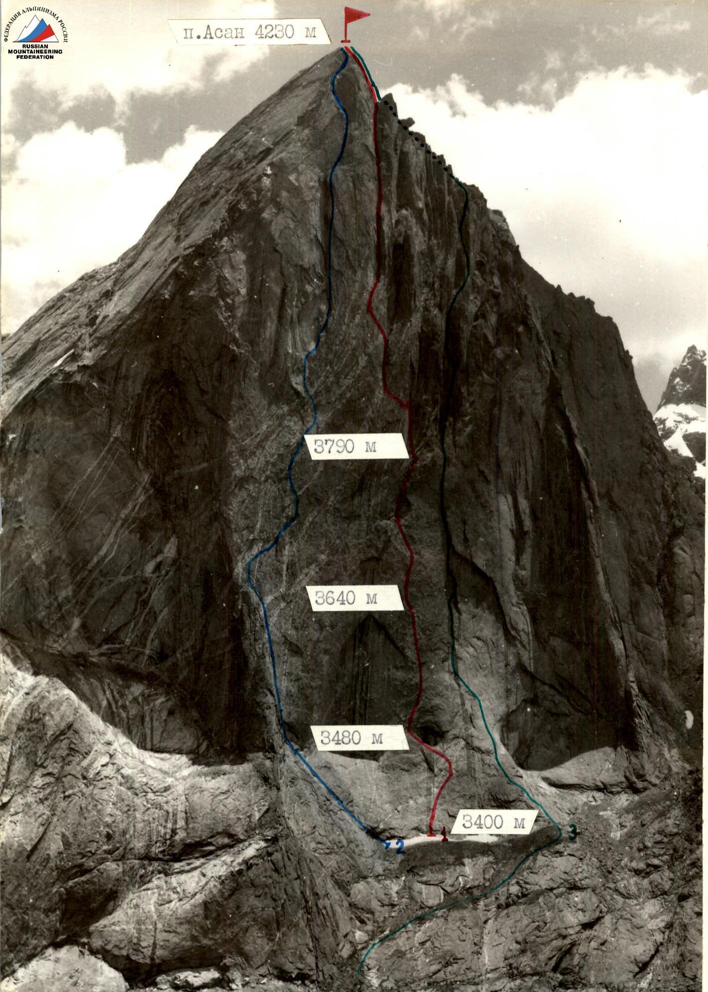
Photo — 1. Date taken — 07/10/1988, 16:00. Lens — "Volna 3M". Distance — 2 km. Height of the shooting point — 3700 m. Shooting point number — 1.
Shooting Points
- 1 — route of the team from the Alpine Club of the Nevsky District, Leningrad, via the "mirror" of the NW wall, 6B category (Rusyaev, 1988)
- 2 — Gorbenco's route via the central NW wall, 6B category, 1986
- 3 — Timofeev's route via the right part of the NW wall, 6B category, 1986
Profile of the route to Peak Asan (4230 m) via the "mirror" of the northwest wall
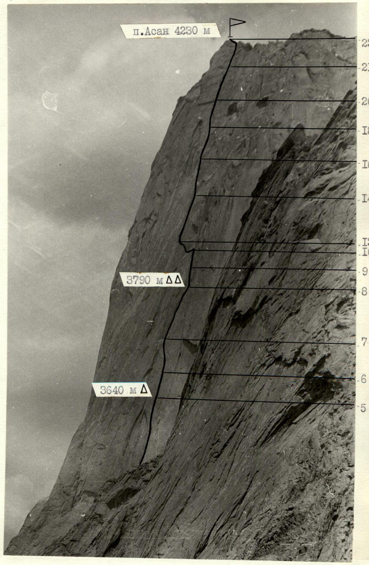
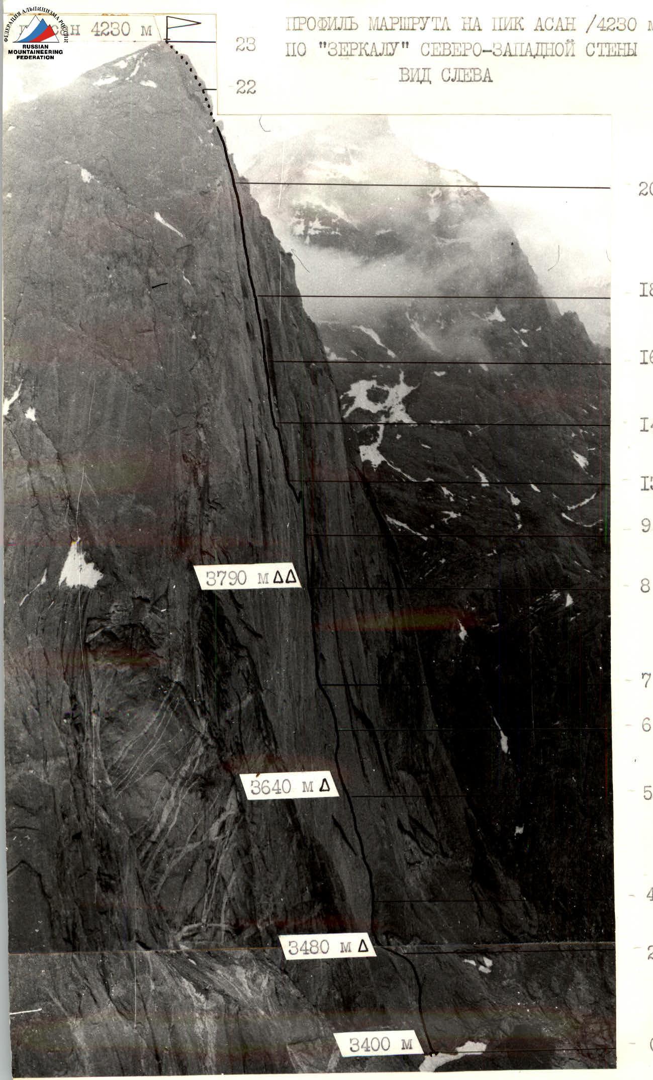
Distance — 4 km. Height of the shooting point — 3900 m. Shooting point — 3.
Tactical actions of the team
The results of the reconnaissance, study of reports, and photographic materials on the NW wall of Peak Asan formed the basis for developing a tactical plan. The planned route was intended to be completed in 4 overnight stays and 1 day of preparation, which matched the actual route completion. It was completed from June 24 to 29, taking 49 climbing hours. The descent took 5 hours.
The team consisted of experienced Masters of Sports: Rusyaev A.V. — captain, Odintsov A.N. — deputy captain, Mayorov E.E., Tsaruk I.F., and young athletes: Dorofeev A.V., Efimov S.V.
All team members have climbing rankings, including one Master of Sports and 4 Candidates for Master of Sports. This composition allowed for flexible planning of the workload on the route, rotation of lead climbers, and an even distribution of tasks among team members. The planned advance preparation ensured that team members not involved in preparation had a proper rest. This allowed the team to maintain a high pace. The bivouac equipment was chosen considering the nature of the planned overnight stays. Given the lack of water in the lower part of the wall, the team brought 2 liters of water. To complete the route, experience with skyhooks and bolt climbing techniques was necessary.
The ascent schedule was as follows:
June 24 — route preparation.
- The duo Mayorov–Efimov climbed 100 m of smooth slab.
- The terrain was deceptively easy; skyhooks were used as artificial holds.
June 25 — 1st working day.
- Main task — processing the vertical wall on R3–R5.
- Problem — maintaining a high pace on artificial holds on the smooth wall.
- Solution — rotation of lead climbing pairs.
- Initially, climbing was on R2–R4; then, it was entirely on artificial holds.
- Belay stations were hanging; thus, the belayer was under no less load than the lead climber.
- At 14:30, the climbing pairs were rotated: Tsaruk–Dorofeev took the lead from Rusyaev–Odintsov.
- After 6 hours, the smooth slab led to a small ledge.
- 165 m of the wall were processed (photos 5, 7).
- The section was completely dry.
- On R2–R3, an overnight stay in hammocks was organized in a niche.
June 26 — 2nd working day.
- Main tasks:
- passing the processed section,
- organizing an overnight stay on R5–R6,
- further processing of the wall.
- There was still no water on the wall.
- In the morning, the Odintsov–Efimov pair led.
- After 2 hours, they had to descend to the niche for the overnight stay to assist Tsaruk, who had injured his shin.
- Quick decision-making and competent actions minimized time losses to descend and hand over the injured climber to the rescue team.
- No violations were noted by the USSR State Sports Committee's authorized representative, Shaposhnikov B.M., and the USSR Championship judges in this incident.
- After 6 hours, the team's work on the wall resumed.
- The tactical plan for the day was adjusted on the go.
- At 19:00, the team reached R5–R6 and set up a hanging bivouac at the planned location (photo 9).
- Thus, the plan was partially fulfilled.
June 27 — 3rd working day.
- Task for the day — reaching R8–R9 and setting up an overnight stay.
- The problematic "Petrel" cornice was passed on the right by the Mayorov–Efimov pair.
- The time lost the previous day, combined with a delay due to bad weather (rain at night and in the morning), added to the challenges.
- Despite this, the team reached the planned overnight location (photo 5) on time.
- Further processing was done by the Dorofeev–Mayorov pair.
- It rained.
- In 2 hours, 70 m of a steep monolithic internal corner were processed.
- A method to overcome the left smooth wall of the internal corner — one of the route's problems — was determined (photo 12).
- It was decided to use a pendulum swing.
- At 20:30, the entire team was on a comfortable ledge (photo 11); with snow available, the water issue was resolved.
June 28 — 4th working day.
- Tasks:
- executing the pendulum swing,
- traversing the vertical wall (R11–R13) when entering the powerful internal corner in the middle part of the route,
- passing the internal corner (R13–R14).
- It rained all night and in the morning; the wall was wet.
- The working day was shortened.
- It was decided to process the planned section for the day and stay overnight at the previous location.
- At 11:00, the Rusyaev–Efimov pair started processing, followed by Dorofeev–Odintsov.
- The complex pendulum swing (photo 13) was successful on the third attempt.
- To execute it, an intermediate belay via bolt hangers was organized.
- The section of extreme climbing on the left edge after the pendulum and the traverse of the vertical wall (photos 16, 17) was completed by 17:00.
- The Dorofeev–Odintsov pair straightened the rope on the pendulum section (photo 14).
- The leading pair then overcame the overhang on R13–R14 and processed the powerful internal corner in the middle part of the wall (R13–R14) by 19:00.
- It rained again in the evening, but the team was in a tent on a comfortable overnight stay.
June 29 — 5th working day.
- A large volume of work was planned for the day: reaching the summit and descending to the base camp.
- At 7:30, the team was already working.
- Within 3 hours, the processed section (R9–R15) was passed, and the ropes were retrieved.
- Ahead, on the next "key" section (R16–R18), the Odintsov–Mayorov–Dorofeev trio worked.
- Initially, they climbed a vertical internal corner (photos 19, 20), then a hanging chimney (photo 22), and a series of internal corners to R14–R22.
- This took 7 hours.
- Further, along a relatively easy ridge (R22–R23), the team reached the summit at 17:50.
- The descent via the NE ridge to the base camp took 5 hours.
Safety measures during the ascent included:
- 1 — high physical, technical, tactical, and psychological preparedness of team members;
- 2 — a tactical plan tailored to the area's specifics;
- 3 — material support, including the use of modern equipment;
- 4 — double belaying for all participants on the route, with the first climber on a double rope (UIAA+UIAA);
- 5 — a safety group below the route (6 people + 1st category doctor), with a specific plan for emergency situations;
- 6 — an observation group below the route, ensuring stable communication between the team and the base camp;
- 7 — long-range radio communication.
Tsaruk's injury from a falling stone in the niche was an element of chance. The route included:
- 2 hot meals per day,
- a daily snack.
Food was planned at 300 g per person per day.
Route description by sections
The route to Peak Asan 4230 m passes through the center of the NW wall via the so-called "mirror" — a 300-meter smooth slab starting at the base of the wall. Route landmarks are:
- 1 — a cornice with a niche "eye" — 100 m from the base of the wall;
- 2 — two symmetrically converging cornices "eyebrows" — 200 m from the base of the wall and 20 m left of the route line;
- 3 — a small cornice "Petrel" in the upper part of the "mirror" — the route touches its right part;
- 4 — the first powerful internal corner to the right of the summit, leading to the ridge;
- 5 — "sloping stone" — a powerful sloping cornice on the ridge (against the sky), to the left of which the route passes.
The heights mentioned in the report were taken from geographical maps and an altimeter, and cross-checked with the assessments of the first ascenders.
Section R0–R1. The beginning of the route (70 m) was 15 m to the right of the first ascenders, using terrain (an internal corner) for 40 m, leading to the same intermediate ledge (5 m to the right) as the first ascenders. This allowed for 60 m without using skyhooks and bolt hangers. From the ledge to the "eye" niche, movement was on a smooth 75° slab on skyhooks for 30 m, with belays via removable bolt hangers. Entry into the niche was made with a 12 m pendulum swing via a left bolt hanger. The total length of the section in the niche is 1 control cairn.
Section R1–R2. From the niche:
- traverse left 8 m,
- then up 10 m,
- and up-right along a sloping internal corner.
For subsequent ropes, the route is straightened, and movement starts almost from the left edge of the niche.
Section R2–R5. Very steep (85°) and complex climbing. On all sections, the movement is uniform — on skyhooks with intermediate belays every 5 m and stations on bolt hangers. Participants require high psychological preparation and skyhook technique. The end is a small ledge (overnight stay of the first ascenders with bolt hangers for hammocks). Here, 2 control cairns.
Section R5–R6. The nature of the terrain and the work corresponds to the previous section. Here, you need to find holes for skyhooks left by the previous group. The direction of movement is towards the right part of the "Petrel" cornice. The cornice is bypassed on artificial holds. Hooks 3–6 mm and small chocks are used. At the end of the section, there is the lower part of a sloping ledge where a "station" is organized. The "mirror" ends here.
Section R6–R9. Here, the wall has terrain features:
- internal corners,
- cracks,
- crevices,
- cornices.
The work for the first climber becomes easier, but the belays remain complex. Large chocks and "friends" work well. The section leads to a good ledge — a lying overnight stay for the entire group. Here, 3 control cairns.
Section R9–R10. One of the key sections on the route. Initially, movement is up an internal corner for 55 m. Then the first climber descends 20–25 m and, gaining momentum from the right wall of the corner, swings left with a pendulum. You need to catch onto a smooth vertical rock and then traverse left behind the outer edge of the left plane of the internal corner. It is advisable to straighten the belays by organizing upper belays.
Section R10–R12.
- Climb up 20 m on a monolithic vertical relief wall.
- Then traverse 30 m left, holding onto a thin flake.
Work with the flake is maximally cautious due to its fragility. The last one descends with rope retrieval.
Section R11–R14. Climb vertically up an internal corner, sometimes turning into a narrow chimney, under an internal corner with a cornice. 20 m before the cornice — traverse left with a 10 m climb and exit onto a narrow 30–50 cm ledge. Here, overnight stays are separate for each climber.
Section R14–R16. Vertical walls with slabs. The terrain is dissected, with good cracks for chocks. Towards the end of the section, it becomes vertical. Under the overhang in a niche, 4 control cairns.
Section R16–R17. An attempt was made to climb the internal corner, but it was found to be wet, "smoothed," with moss and dead cracks. It was necessary to descend and move 5 m to the right onto the right plane of the internal corner, which is well dissected but overhanging. Chocks and hooks work well. Short sections are passed with the free hand.
Section R17–R20. A powerful overhanging cornice with a crack is passed on artificial holds. Further, there is a long 100-meter chimney. The walls of the chimney are smoothed by water and snow, the cracks are dead, damp; thus, climbing becomes significantly more complex than it appears visually.
Section R20–R23. A powerful internal corner leads to the ridge; climbing remains complex until reaching the ridge. Belays are complex.
Section R23–R24. Climb to the summit on relatively easy rocks. Descent from the summit is via rappels, initially to the north (15 rappels), then a transition to the north ridge and descent along it (3–4 sport rappels), and further along the east wall (5–6 rappels) to the east slope. Along the slope, descend to the moraine towards Peak 4810.
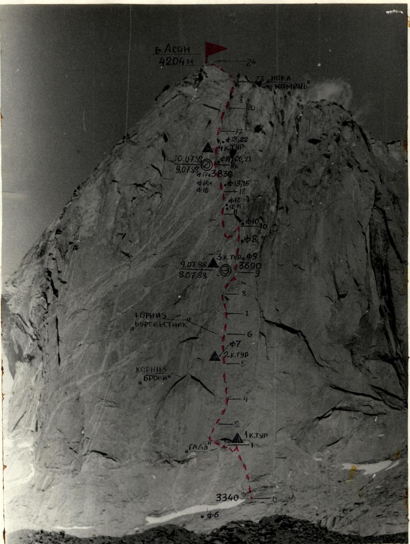
Photo 5. Technical photograph of the route. Taken on 06/30/1988 at 17:00 with a "Zenit-E" camera, "Helios 44-2" lens with a focal length of 40 mm. Approximate distance to the object — 2 km. Height of the shooting point ≈ 3200 m. Shooting point — FZ.