Ascent Passport
- Region, gorges: Turkestan Range, Karavshin. 5.4.3.
- Name of the peak: Asan, route name: via the center of NW wall (Timofeev 1988). 4230 m.
- Proposed: 6B category of difficulty.
- Route character: rock.
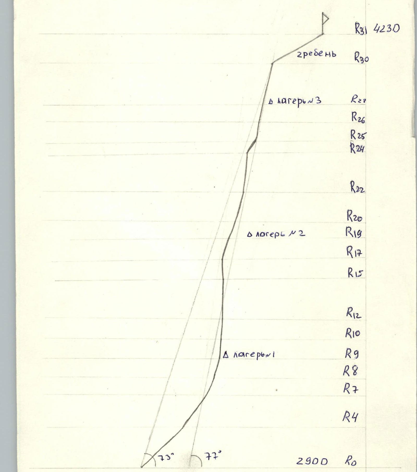
- Route height difference: 1330 m, maximum 500 m. Route length: 1391 m. Length of sections: V category of difficulty 300 m, VI category of difficulty 545 m. Average steepness: main part of the route 77°, total route 73°.
- "Hooks" left on the route: Total: 6, including 4 bolted. Hooks used on the route: Stationary bolted 2 pcs., including 2 ITO. Removable bolted 8 pcs., including 5 ITO. Total ITO used 174 pcs., including 94 skyhooks.
- Team's working hours: 74 hours, 10 days.
- Leader: Morozov D.V. CMS Participants: Tarnakin Yu.A. CMS, Kondrashov V.V. CMS, Valeev V.A. 1st sports category
- Coach: Igolkin V.I. MS
- Departure to the route: 7:00, January 2, 2007. Reached the summit: 11:00, January 13, 2007. Returned to the base camp: 17:00, January 14, 2007.
- Organization: Team of the Regional Sports Committee of Chelyabinsk region.
Drawn route profile
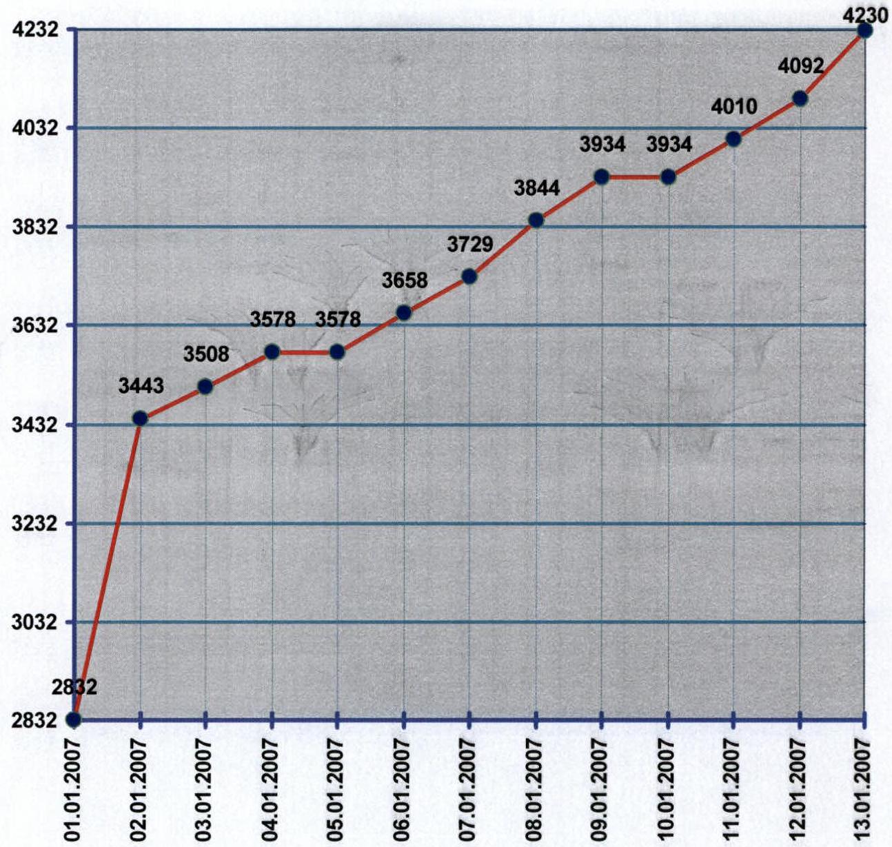
Ascent Schedule
| Working time (h) | 12 | 8 | 7 | 0 | 8 | 5 | 8 | 6 | 0 | 8 | 8 | 4 |
|---|---|---|---|---|---|---|---|---|---|---|---|---|
| Wind (m/s) | 5 | 6 | 12 | 20 | 10 | 10 | 9 | 11 | 18 | 8 | 7 | 7 |
| Temperature (°C) | -10 | -12 | -9 | -14 | -12 | -10 | -15 | -15 | -18 | -12 | -10 | -8 |
| Weather conditions | ||||||||||||
| Natural phenomena | snow | snow, hurricane | snow | snow | earthquake | snow | snow |
Area Photopanorama
Peak Asan (4230 m). Slopes of peak Usen (4378 m). Peak Yrchilta (4507 m). Peak 4810 m.
Route Scheme in UIAA Symbols
| Anchor Hooks (ITO) | Placement Elements (ITO) | Bolted Hooks (ITO) | Sky-hooks (ITO) | Route scheme in UIAA symbols. ASAN Timofeev route 6A category of difficulty. | Section length (m) | Steepness (°) | Difficulty |
|---|---|---|---|---|---|---|---|
| 5/5 | 18/18 | photo №2 R8 | 50 | 75 | VI A3 | ||
| 3/2 | 2/1 | 15/15 | photo №1 R7 | 45 | 65 | VI A3 | |
| 4/1 | 4/4 | R6 | 40 | 55 | V A3 | ||
| 1 | 1 | 4/4 | R5 | 10 | 55 | V A3 | |
| 3/1 | 5/2 | R4 | 50 | 50 | V | ||
| 2 | 3 | R3 | 70 | 45 | IV | ||
| 3 | 4 | R2 | 100 | 45 | IV | ||
| 2 | R1 | 100 | 45 | III | |||
| 2 | R0 | 100 | 45 | III |
Route Scheme in UIAA Symbols
| Anchor Hooks (ITO) | Placement Elements (ITO) | Bolted Hooks (ITO) | Sky-hooks (ITO) | Route scheme in UIAA symbols. ASAN Timofeev route 6A category of difficulty. | Section length (m) | Steepness (°) | Difficulty |
|---|---|---|---|---|---|---|---|
| 2/1 | 3/2 | 1/1 | 4/4 | chip R16 | 15 | 95 | VI A2 |
| 3/2 | 4/3 | 1/1 | 6/6 | chip cornice 0.8 m photo №5 R15 | 40 | 95 | VI A2 |
| 4/2 | 4/3 | 4/4 | chip cornice 0.5 m R14 | 40 | 90 | VI A2 | |
| 2/2 | 2/2 | 1 | chip cornice 1.5 m R13 | 15 | 90 | VI A3 | |
| 3/1 | 4/3 | 4/4 | R12 | 35 | 90 | VI | |
| 3/2 | 2/2 | R11 | 20 | 85 | VI | ||
| 2/1 | 1 | 2/2 | Photo №4 R10 | 20 | 85 | VI A2 | |
| 4/1 | 3/2 | 8/8 | Photo №3 R9 camp №1 | 45 | 85 | VI |
Route Scheme in UIAA Symbols
| Anchor Hooks (ITO) | Placement Elements (ITO) | Bolted Hooks (ITO) | Sky-hooks (ITO) | Route scheme in UIAA symbols. ASAN Timofeev route 6A category of difficulty. | Section length (m) | Steepness (°) | Difficulty |
|---|---|---|---|---|---|---|---|
| 2 | 3 | R24 | 35 | 50 | V | ||
| 6/3 | 6/6 | cornice 1.8 m R23 | 50 | 90 | VI A1 | ||
| 4/2 | 4/3 | 4/4 | photo №6 R22 | 40 | 85 | VI A1 | |
| 4/3 | 5/2 | 1 | 3/3 | cornice 0.5 m R21 | 50 | 75 | VI A1 |
| 3/1 | 2/1 | R20 | 30 | 75 | VI | ||
| 3/2 | 4/2 | 2/2 | R19 camp №2 | 40 | 70 | V | |
| 4/1 | 4/2 | 2/2 | R18 | 40 | 70 | V | |
| 3/2 | chip R17 | 20 | 60 | V |
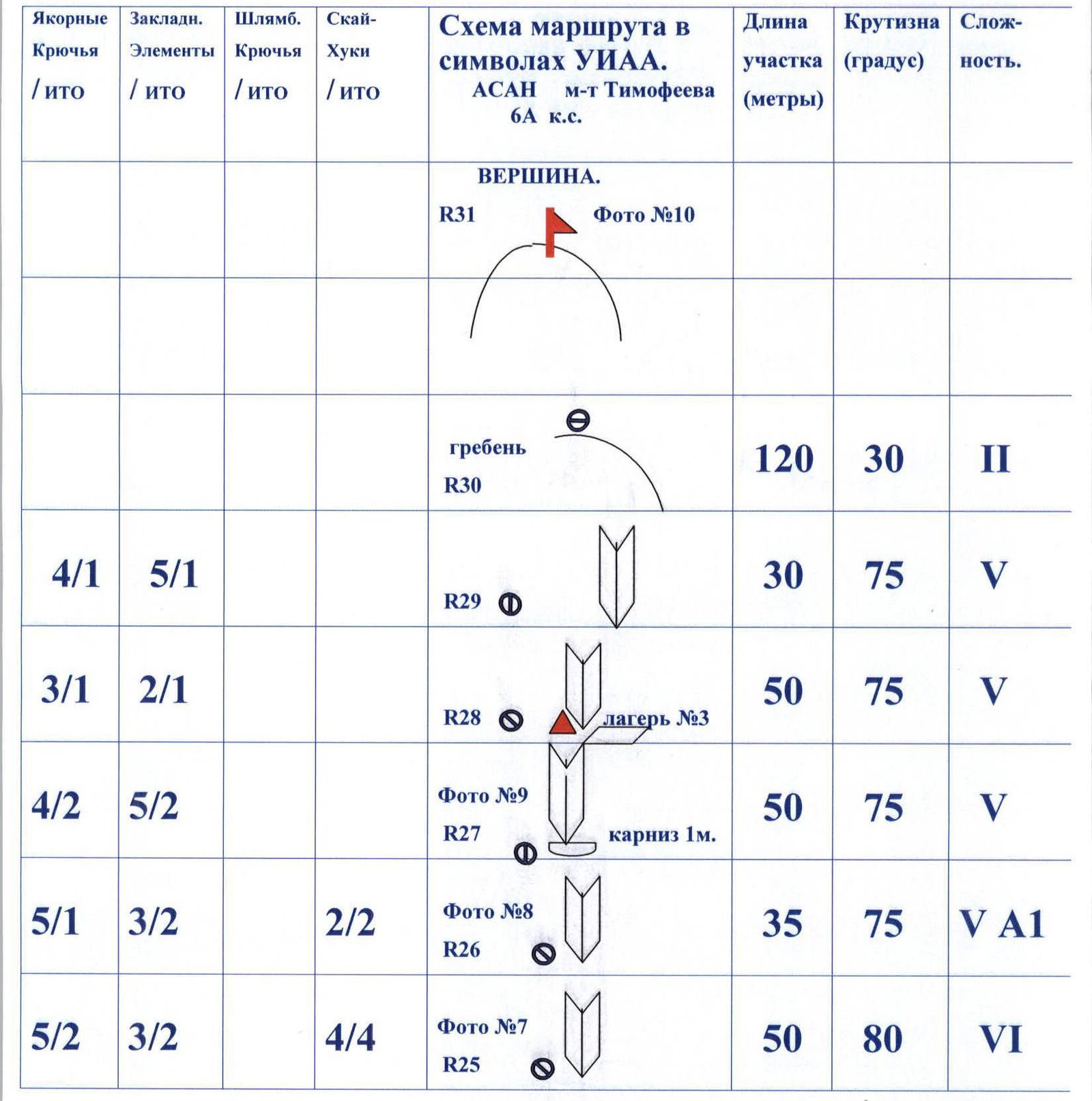
Route Scheme in UIAA Symbols
| Anchor Hooks (ITO) | Placement Elements (ITO) | Bolted Hooks (ITO) | Sky-hooks (ITO) | Route scheme in UIAA symbols. ASAN Timofeev route 6A category of difficulty. | Section length (m) | Steepness (°) | Difficulty |
|---|---|---|---|---|---|---|---|
| SUMMIT. R31 Photo №10 | |||||||
| ridge R30 | 120 | 30 | II | ||||
| 4/1 | 5/1 | R29 | 30 | 75 | V | ||
| 3/1 | 2/1 | R28 camp №3 | 50 | 75 | V | ||
| 4/2 | 5/2 | Photo №9 R27 cornice 1 m. | 50 | 75 | V | ||
| 5/1 | 3/2 | 2/2 | Photo №8 R26 | 35 | 75 | VA1 | |
| 5/2 | 3/2 | 4/4 | Photo №7 R25 | 50 | 80 | VI |
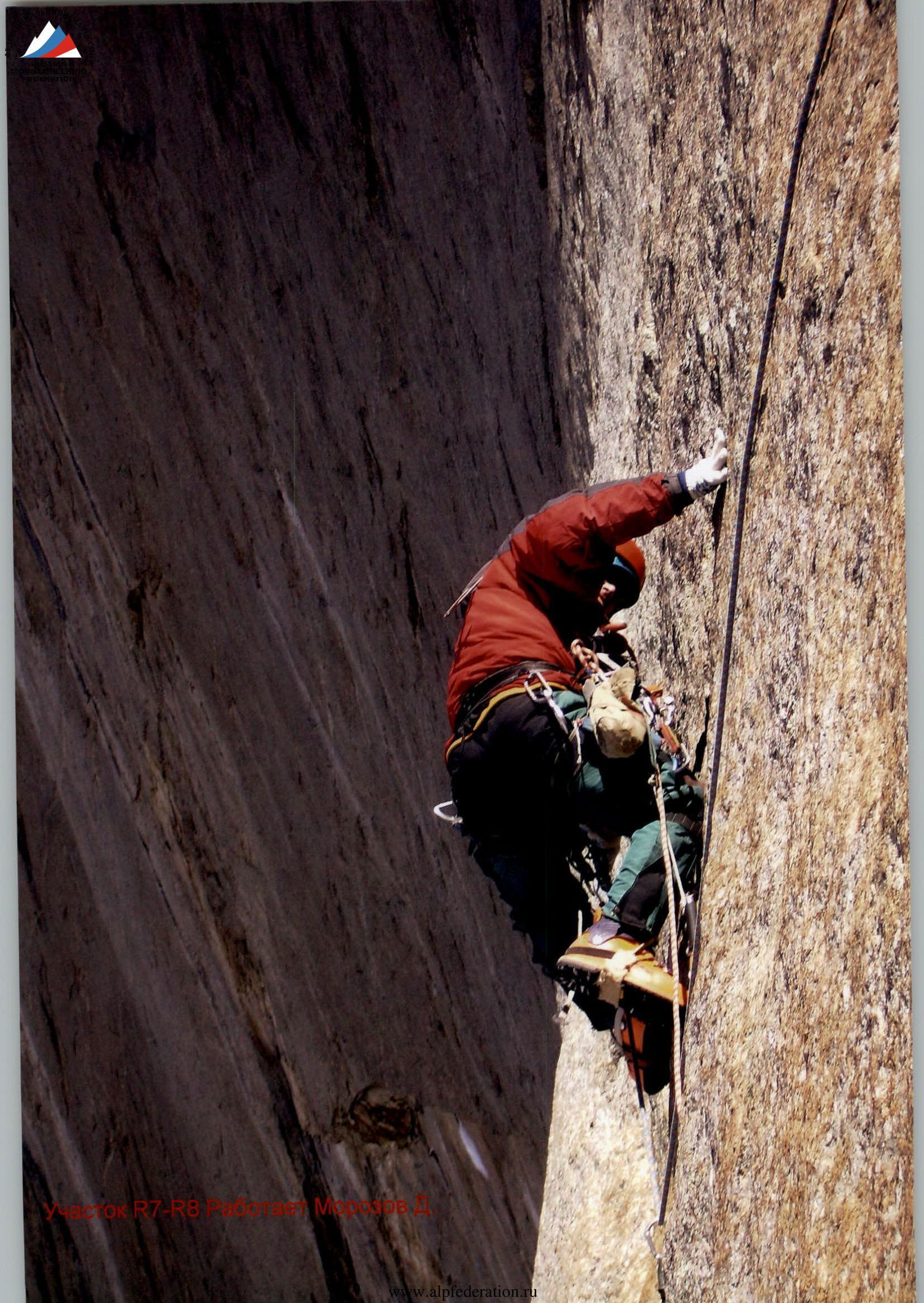
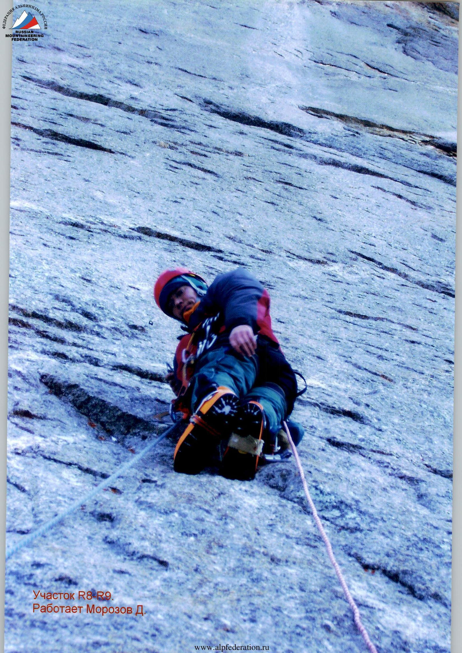
Section Photos
Section R7–R8. Morozov D. is working.
Section R8–R9. Morozov D. is working.
Section R9–R10. Valeev V. is working.
Section R15–R16. Overcoming a cornice. Valeev V. is working.
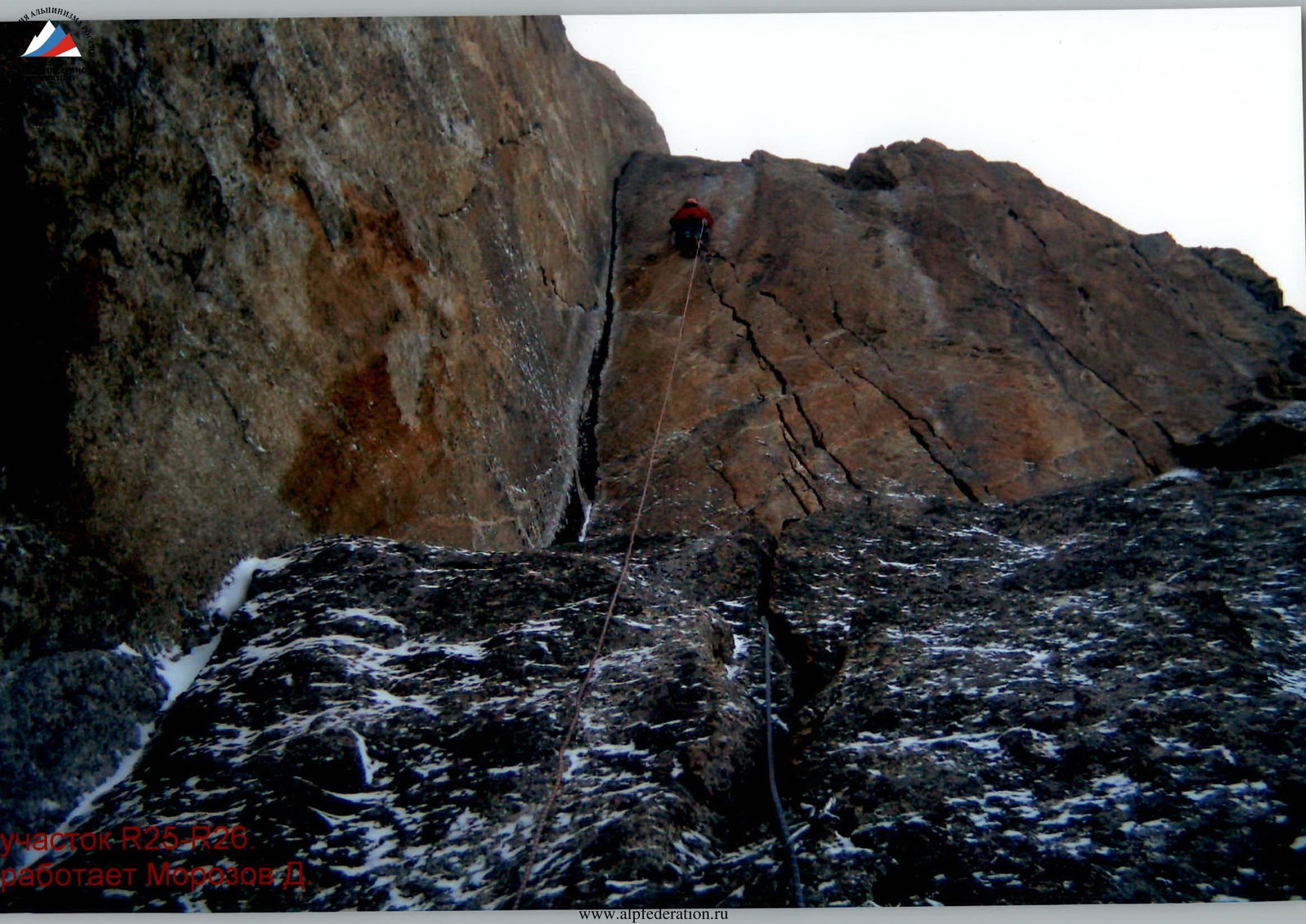
Section R26–R27. Kondrashov on the belay.
Section R27–R28 breaking away from the station.
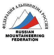
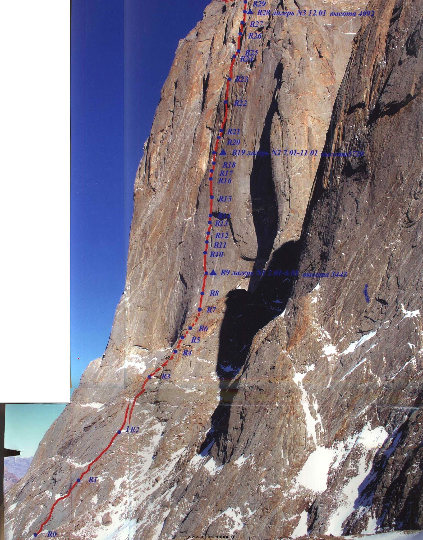
Route Photos
 R31 SUMMIT 13.01.2007 12:00, altitude 4320 m.
R28 camp №3 12.01, altitude 4092 m.
R19 camp №2 7.01–11.01.
R9 camp №1 2.01–6.01, altitude 3443 m.
R31 SUMMIT 13.01.2007 12:00, altitude 4320 m.
R28 camp №3 12.01, altitude 4092 m.
R19 camp №2 7.01–11.01.
R9 camp №1 2.01–6.01, altitude 3443 m.
 R31 SUMMIT 13.01.2007 12:00, altitude 4230 m.
R19 camp №2 7.01–11.01, altitude 3729 m.
R9 camp №1 2.06.01, altitude.
R31 SUMMIT 13.01.2007 12:00, altitude 4230 m.
R19 camp №2 7.01–11.01, altitude 3729 m.
R9 camp №1 2.06.01, altitude.