PASSPORT
I. Rock class
2. Pamir-Alai, Karasu gorge
3. V. Asan (4230 m) via the right part of the N wall
4. Proposed 6B category of difficulty, first ascent
5. Height difference: 1030 m, length - 1435 m. Length of sections with 5-6 category of difficulty - 630 m. Average steepness of the main part of the route 70° (3300-4150 m), including 6B category of difficulty 36° (3400-3700 m); 81° (3300-3360 m).
6. Used on the route: rock pitons - 8/0, bolt pitons - 13/8, chocks - 220/37.
7. Climbing hours - 45, days - 4.5 (including descent).
8. Overnights: 1, 2 - in tents on a platform; 3rd - three in hammocks, three on rock ledges; 4th - on comfortable ledges on the ridge.
9. Team leader: TIMOFEEV Sergey Vladimirovich, Candidate Master of Sports. Participants: SMETANIN Nikolay Aleksandrovich, Master of Sports; AVTOMONOV Viktor Petrovich, Master of Sports; KUZNETSOV Pyotr Valentinovich, Candidate Master of Sports; PUSHKAREV Semyon Alekseyevich, Candidate Master of Sports; KUSTOV Evgeny Vasilyevich, Candidate Master of Sports.
10. Coach: KHOROSHIKH Alexander Nikolayevich.
11. Start of the route: June 16, 1988; summit: June 20, 1988; return: June 20, 1988.
12. Organization: RSFSR State Committee for Sports.
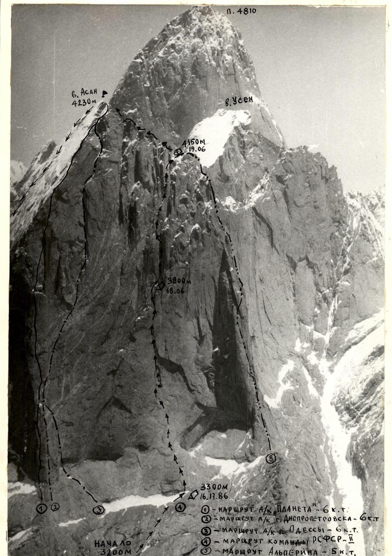
General photo of the summit. Taken on June 12, 1988, 13:20 from the opposite slope (3900 m). Distance 3 km, lens - Helios-44 (focal length - 58 mm). Shooting point #1.
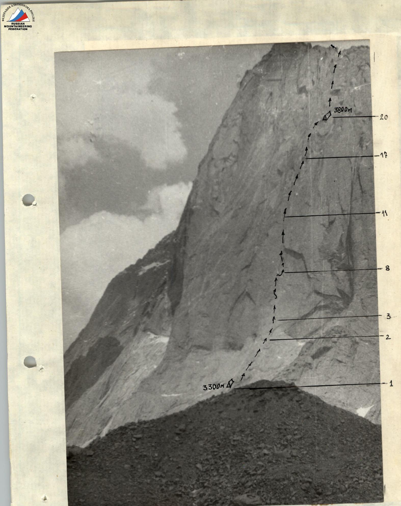
Photo 2. Profile of the wall on the right. Taken on June 13, 1988, 15:00 from the Karasu glacier moraine (3100 m). Distance 600 m, lens - Helios-44 (focal length - 58 mm). Shooting point #2.

Photo 3. Profile of the wall on the left. Taken on June 13, 1988, 10:30 from the opposite slope (3400 m). Distance 4 km, lens - Helios-44 (focal length - 58 mm). Shooting point #3.
Team's Tactical Actions
The time schedule was followed precisely, and no adjustments were needed along the way.
The change of leaders and the organization of rope team movement were carried out according to the tactical plan:
- Day 1: Kuznetsov - Pushkarev; Timofeev - Kustov.
- Day 2: Smetanin - Avtomonov; Kuznetsov - Pushkarev.
- Day 3: Timofeev - Kustov; Smetanin - Avtomonov.
- Day 4: Kuznetsov - Pushkarev; Timofeev - Kustov.
Each rope team worked at the front for 5-7 hours over 1.5 days, with mandatory change within the team. This regime ensured good rest for all team members and contributed to safe work without fatigue.
The first climber was belayed by two ropes (one обязательно with an IAA marking) through an additional braking device. The rest of the team members moved along the fixed ropes with top belay, except for the third climber, who moved along the fixed ropes with bottom belay. The last climber also used an IAA safety rope. Only tested equipment was used for belaying. Samples of all equipment were tested at the Sverdlovsk Research Institute of Physical Culture and Sports stand. Chocks were mainly used for organizing intermediate belay points. At stations - oppositional systems of 3-6 elements, blocked by a special loop made of red webbing. The assortment and quantity of equipment corresponded to the requirements of the route.
Overnights:
- 1st and 2nd on a ledge under the wall;
- 3rd - on the wall (three in hammocks, three on small ledges);
- 4th - on the ridge on comfortable ledges.
There were no falls or injuries. Key sections of the route were climbed using free climbing. Only smooth slabs at the beginning of the route were climbed using skyhooks on inclusions of harder rock and bolt holes with belay on bolt pitons. To move from one disappearing crack to another, pendulum moves were used (2 times on bolt pitons, 6 times on chocks and pitons). A two-hour thunderstorm on June 16 did not affect the team's pre-planned actions. It only slowed down the movement pace, wetting the rocks.
The rescue team, authorized to climb "sixes," was located at the base camp, the coach and observers - on the glacier.
Radio communication was carried out according to the scheme: wall - observers; observers - base. There were no missed communication sessions.
R0 - The section starts from the point where the scree is highest under the V. Asan rocks to the left of the end of the Karasu glacier. Overcoming 8-10 m of "ram's foreheads," we reach the scree of a large ledge that crosses the entire Asan massif. From left to right along the scree ledges, sometimes along "ram's foreheads," we reach a long narrow snow patch, at the end of which a bivouac is set up. R1 - From the bivouac, slightly to the left of the edge of a cone-shaped rock outcrop, up a crack 100 m (belay with chocks). Photo 5. R2 - Move left onto a slab with unclear, sloping holds. Along the slab left-upward about 30 m (belay with bolt pitons). Then a pendulum move left-down to an internal corner. Up the internal corner 12-15 m to a ledge and then along a split another 10 m to the next ledge. Belay point using a bolt piton. R3-R4 - Along the slab 10-12 m of difficult climbing, then 30 m upward using skyhooks (belay via bolt pitons) to a ledge. R5 - Along the ledge left-upward 25 m, overcoming a 1.5-meter wall that interrupts the ledge. The ledge gradually turns into a vertical internal corner with a crack (belay with chocks). R6 - The corner becomes unclear, the crack narrows. 20 m of extremely difficult climbing. Belay with rock pitons. R7 - The internal corner flattens out to the left. Upward about 15 m. Climbing is difficult. Then a pendulum move right-down 12-15 m to the base of an internal corner with a wide crack. Photo 6. R8 - 40 m along the internal corner under a 1.5-meter cornice, extending left for 8-10 m. Belay with large hexes and stoppers. Photos 7, 8. R9 - Passing the cornice, under which water flows continuously, along a crack to the left. Climbed using artificial aids with the use of the entire arsenal of mountaineering equipment (except pitons). R10 - Upward along a crack-chimney 12 m, then a move left onto a flake. Along the flake upward about 30 m to a long (≈4 m) 0.2 m ledge. Bolt piton belay point for leader change. Control cairn on a rock piton. Photo 9. R11 - Move right into a hanging crack and upward 20 m to a 1.5-meter cornice. R12 - Bypassing the cornice, further along the crack to the next cornice 5 m long. R13 - The cornice is traversed left using artificial aids. R14 - Upward along the crack another 10 m to a belay point. Photo 10. R15 - Further along the crack 30 m. Belay along the entire length of the crack (R8-R15) with chockstones of large size. R16 - The crack ends and turns into sloping ledges, leading right-upward to a vertical internal corner (15 m). R17 - 7 m upward along the internal corner with a chimney. All belays from here to the end are only with chocks. R18 - A series of ledges and walls left-upward 40 m. R19 - Right, a wall 6 m, then an internal corner right-upward 15 m to a series of ledges at the base of a very large internal corner. Overnight stay. Control cairn. R20 - Along a destroyed wall 10 m, then along a thin crack in the internal corner 15 m using artificial aids. A pendulum move right to large cracks on the right side of the internal corner. Along the cracks, moving from one to another, another 20 m. Hanging belay point for leader change. R21 - Further along the cracks for 50 m. The wall becomes steeper and ends with a series of cornices. Another hanging belay point. R22 - Climb another 6 m, double pendulum left-down to the base of a thin crack, leading to the outer edge of the left side of the large internal corner. Climbing upward 16 m. R23 - The relief disappears, and the remaining crack is climbed using artificial aids. A small ledge on the outer edge. Belay point for leader change. R24 - Left along a wall 4 m, then a series of ledges and internal corners right-upward 40 m. Belay point under a large stone. R25 - Upward along a crack left, a stone is climbed using artificial aids. Then right-upward to a comfortable ledge 40 m. Belay point. R26 - Upward 20 m to the base of a chimney with a large jammed hanging stone. The stone is bypassed on the left (CAUTION! Loose rocks). Along the chimney 30 m. Belay point. R27 - Upward 20 m to a ledge, move left and upward along a wall 30 m. Belay point. R28 - Upward 5 m, then move left into an internal corner. R29 - Upward along the internal corner with ice and snow 30 m to a wall. Belay point. R30 - Along the wall right and along an internal corner with a split upward 10-12 m, exit onto a sloping ledge with loose stones. R31 - Right-upward along a large scree 30 m to the ridge. Overnight stay. R32 - Along the ridge 200 m to the summit.