- Rock climbing.
- Pamir-Alay, Turkestan Ridge.
- Peak Asan via NW wall, CTMGW 5.4.3, 4230 m
- 6A category of difficulty
- Height difference — 830 m, including the wall — 780 m
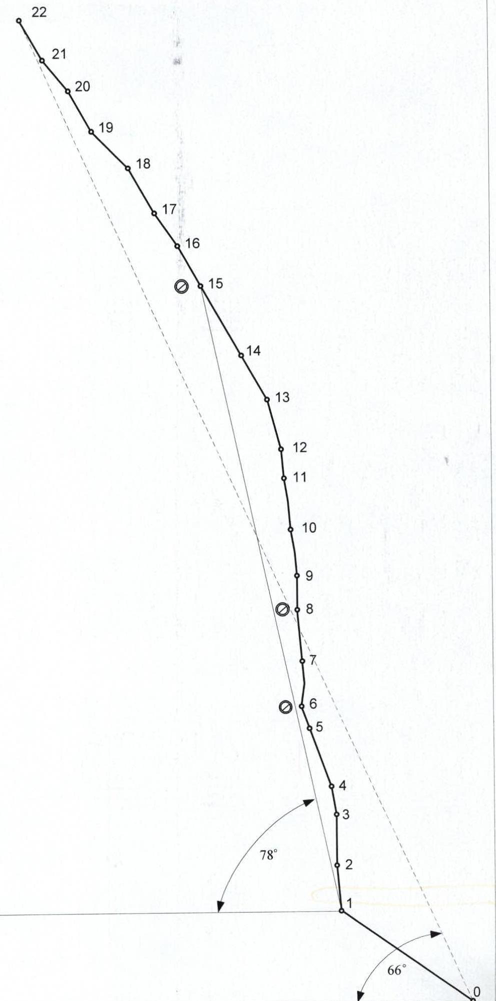
Length — 1015 m. Length of sections with 5–6 category of difficulty — 450 m, including: 6 category of difficulty — 185 m. Average steepness — 66°, including: wall — 78°.
- Pitons used:
Rock Drill-in Nuts Ice 60/7 5/24 90/5 0/0
-
Team's travel hours: 42 hours.
-
Overnight stays: 1, 3, 4 — lying in a tent 2 — hanging in hammocks
-
Team leader: Pugachev Sergey Alexandrovich, MS
Team members:
- Zagirnyak Mikhail Vasilievich, MS
- Maksimenya Alexander Grigorievich, CMS
-
Coach: Zagirnyak Mikhail Vasilievich, MS, category 1 instructor-methodologist.
-
Departure to the route: July 23, 2004 summit: July 27, 2004 (14:00) return: July 28, 2004.
-
Organization: Poltava (Lugansk) regional federation of mountaineering and rock climbing.
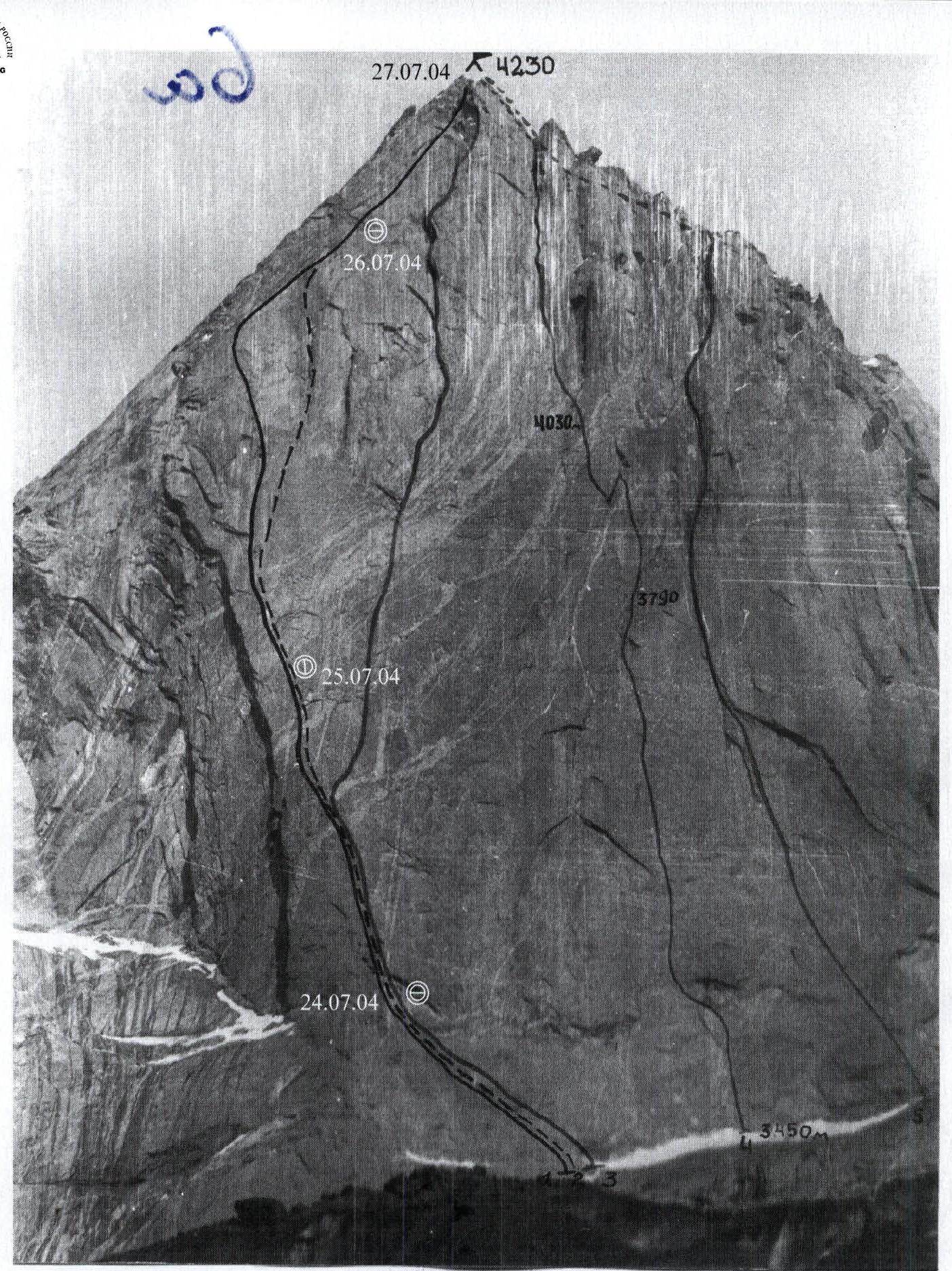
Photo — I Date taken — June 25, 1991, 16:00. Lens — Volna-3 M Distance — 2 km. Height — 3700 m. Photo number — I
Photo scheme — I
1 — Pogorelov's route via NW wall 6A category of difficulty 1986 2 — Moroz's route via NW wall 6A category of difficulty 1986 3 — Gorbenko's route via Central NW wall 6A category of difficulty 1986 4 — Rusyaev's route via Central NW wall 6B category of difficulty 1988, team's route 5 — Timofeev's route via the right part of NW wall 6B category of difficulty 1988.
Route profile M 1:3500
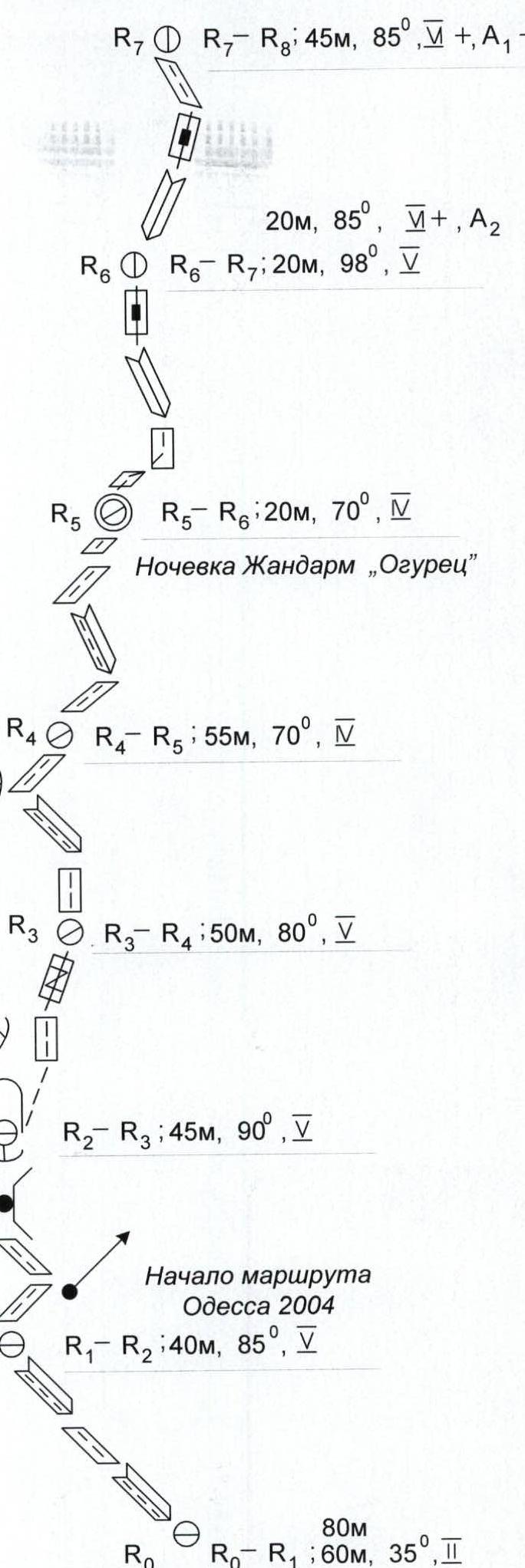
Ascent route diagram to peak Asan via NW wall in UIAA symbols (sheet 1)
Ascent route diagram to peak Asan via NW wall in UIAA symbols (sheet 2)
R7–R8; 45 m, 85°, V+, A1–A2 20 m, 85°, V+, A2 R6–R7; 20 m, 98°, V R5–R6; 20 m, 70°, V Overnight stay at "Gendarme 'Ogurets'" R4–R5; 55 m, 70°, V R3–R4; 50 m, 80°, V R2–R3; 45 m, 90°, V Start of "Odessa 2004" route R1–R2; 40 m, 85°, V 80 m R0–R1; 60 m, 35°, II
Ascent route diagram to peak Asan via NW wall in UIAA symbols (sheet 3)
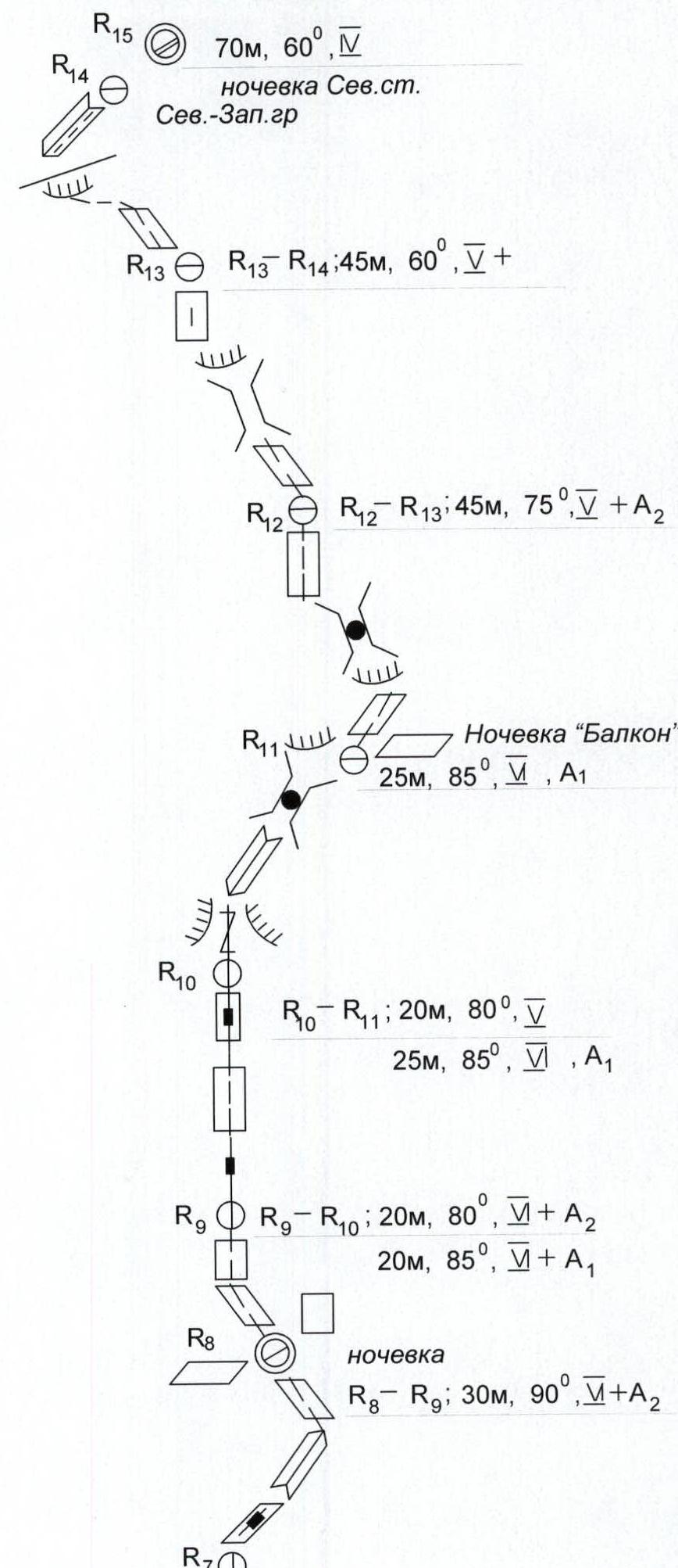
R15 R14 70 m, 60°, V Overnight stay at "North wall" NW ridge R13–R14; 45 m, 60°, V+ R12–R13; 45 m, 75°, V+A2 Overnight stay at "Balcony" 25 m, 85°, V, A1 R10–R11; 20 m, 80°, V 25 m, 85°, V, A1 R9–R10; 20 m, 80°, V+A2 20 m, 85°, V+A2 R8 Overnight stay R8–R9; 30 m, 90°, V+A2 R7
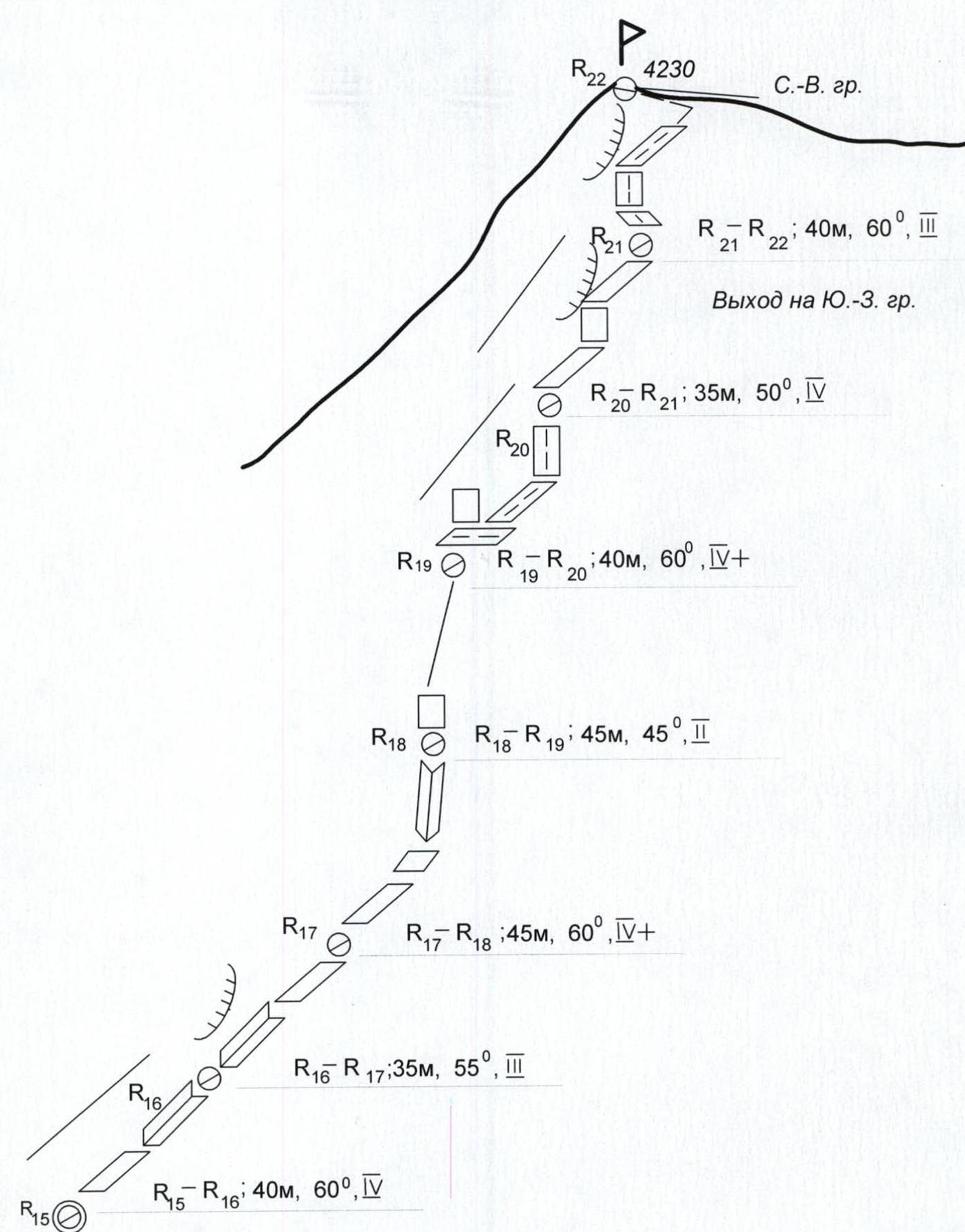
Ascent route diagram to peak Asan via NW wall in UIAA symbols (sheet 4)
R22 P 4230 NE ridge R21–R22; 40 m, 60°, III Exit to SW ridge R20–R21; 35 m, 50°, IV R19–R20; 40 m, 60°, IV+ R18–R19; 45 m, 45°, II R17–R18; 45 m, 60°, IV+ R16–R17; 35 m, 55°, III R15–R16; 40 m, 60°, IV
Preparation for the ascent
The object of the ascent — the Northwest wall of peak Asan — attracted the team's attention in 2001 during the Lugansk regional mountaineering federation's training camp. Then the team members made ascents via nearby routes, from where they observed the state of the possible ascent route and took photos.
When preparing for the current season, the team followed a plan. Autumn and winter — general physical training, rock climbing (in the Zuevka settlement area, Donetsk region, and in Crimea). In January and May, team members participated in training camps and the Ukrainian Championship in the Crimean mountains, where they completed routes of 5th and 6th category of difficulty.
The main feature of the chosen route is its great steepness and length. Having bivouac equipment: tent, sleeping mats, gas stove – was essential.
Since the ascent was made in a "triplet", the load on the participants was quite significant. Another feature of this route is the difficulty in choosing the direction of movement, i.e., in orientation. All this could not but affect the dynamics of ascents – over the past five years, this was only the second passage – with the removal of a note from the control tour. In addition, traversing the ridge to and from the main summit after bad weather greatly complicated and slowed down the movement.
As confirmation of the above — the previous passage of the route by a Moscow team in 2003 took seven days.
A feature of the team's preparation for the ascent was the participants' long stay in Crimea. Therefore, it was decided to go the route directly, without preliminary warm-up and training routes. This was facilitated by a large number of ascents in Crimea.
From the tactical features of the passage: in conditions of constant bad weather, a tent and a tarp were taken for overnight stays, as well as a careful and high-quality selection of bivouac equipment.
Team's tactical actions
(tactical plan)
The team followed the route in full compliance with the tactical plan and time schedule. Weather conditions during the ascent did not allow planning the passage of the route with two overnight stays.
Almost the entire route, the rope team moved using fixed ropes. Only on ridge sections was the movement alternating.
Basically, the first climber went free climbing or using artificial support with insurance through a "figure eight".
The rope team moved on a double rope. Both — with a UIAA label. Equipment was passed on at stations.
There were no problems during the passage of the route; the team had sufficient technical means to pass any terrain.
The availability of individual nutrition for each participant contributed to maintaining a high pace.
The team took on the route:
- drill-in pitons,
- rock pitons,
- nuts,
- cams,
- thin petal titanium pitons,
- thin anchor titanium pitons.
In the lower and middle parts of the route, thin pitons and small nuts were mainly used, in the upper part — wedges and cams.
Insurance stations were organized on blocked pitons, whenever possible, away from probable rockfall from above. On vertical sections, the first climber's insurance was carried out especially carefully. The fact is that intermittent rain with thunderstorms every day in the afternoon made voice communication difficult. These interferences were constant, but the movement did not stop. Except for the forced stop on July 25, 2004, when heavy rain interrupted our movement, and we set up a hanging overnight stay on the wall.
Drill-in pitons were used to ensure safety on a hanging bivouac (2) and on the wall part of the route, where the available pitons did not meet the requirements. The team took a necessary water supply on the route. Throughout the entire route, the team had radio communication with the base camp.
According to the tactical plan, the team descended from the summit via its Eastern shoulder.
Time schedule
- July 23, 2004 — Approach from the base camp.
- July 24, 2004 — Work on the route to "Ogurets" (the only place for a normal overnight stay on the route), and further processing of the route.
- July 25, 2004 — Passage of the lower part of the route's wall, hanging overnight stay.
- July 26, 2004 — Passage of the upper wall part of the route and exit to the "roof".
- July 27, 2004 — Exit to the summit (and start of descent).
- July 28, 2004 — Descent to the base camp.