Passport
-
Rock climbing category.
-
Pamir-Alay, Turkestan Ridge.
-
Peak 4230 m (Asan), via the spur of the Western wall.
-
Proposed category: 5B, first ascent.
-
Height difference 820 m, route length 1100 m.
Length of sections with 5-6 category difficulty is 530 m, including 140 m of 6th category.
-
Average slope of the route is 63°, up to the ridge it's 70°.
-
Number of pitons used:
Rock pitons 130/26, bolt pitons 2/1, chocks 91/14
-
Climbing time: 32 hours, duration: 3 days.
-
Overnight stops: 1st bivouac under the wall, 2nd on a balcony (uncomfortable).
-
Team leader: Alperin Vladimir Maevich, Master of Sports Team members:
- Gorbenko Mstislav Mstislavovich, Master of Sports
- Korolev Anatoly Mikhailovich, Candidate for Master of Sports
- Kaver Igor Kirillovich, Candidate for Master of Sports
- Bazalevsky Nikolai Mikhailovich, Candidate for Master of Sports
-
Coach: Gorbenko Mstislav Mstislavovich, Master of Sports
-
Start of the climb - July 8, 1986 Summit - July 10, 1986 Return - July 11, 1986
-
Odessa Regional Council "Avangard" of the "Trud" Sports Society "Odessa" Alpine Club
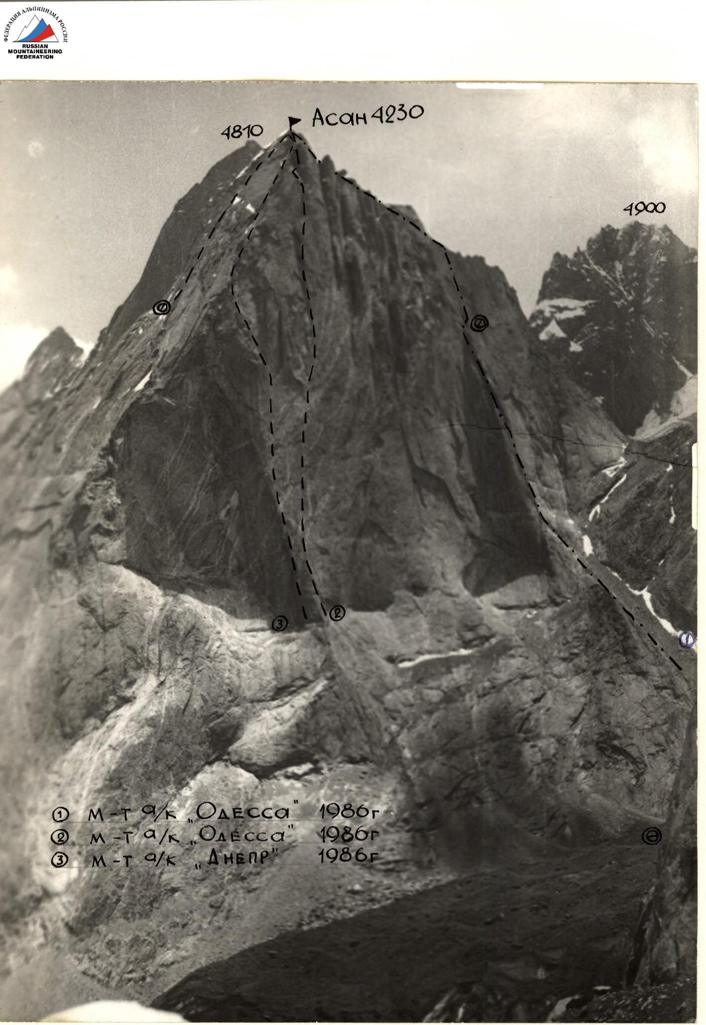
Photo 1
- Photo taken from the opposite slope on July 14, 1986. "Geliios-44"
- Distance 2500 m
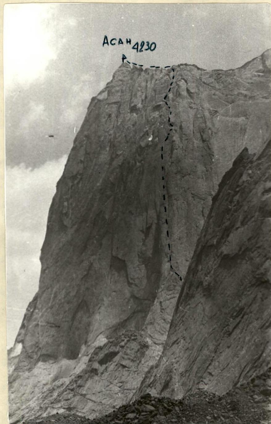
Photo 2. Profile of the wall on the right
- Photo taken from the opposite slope
- Distance 2000 m. "Geliios-44"
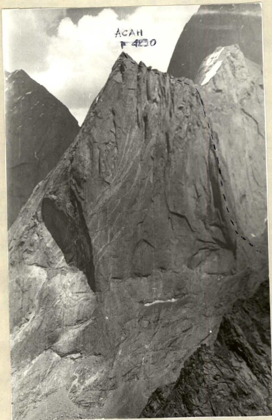
Photo 3. Photo of the wall on the left. Taken from the left side of the middle part of the glacier. July 28, 1986, 15:00 "Geliios-44"
3. Tactical Actions of the Team
The tactical plan for the ascent was made for 3 days, taking into account:
- height difference of 820 m,
- 10-12 hour working day,
- estimated length of sections with 5-6 category difficulty around 400 m,
- team's capabilities,
- presence of smooth sections on the wall,
- cornices,
- need to carry water onto the wall.
The route was completed in full accordance with the tactical plan. The team's tactical actions on sections with 5-6 category difficulty were as follows:
- the leader climbed without a backpack using free climbing or artificial techniques (ITO)
- organized an anchor and rope protection (perils)
- the rest of the team climbed using the rope protection with their backpacks and with top-rope belay.
Sections with 2-4 category difficulty were climbed by rope teams independently.
During the day, the lead climber was changed regularly. The leaders were:
- Gorbenko,
- Alperin,
- Bazalevsky.
The Korolev - Kaver rope team removed pitons, carried loads, and organized bivouacs.
4. Route Description by Sections
Approach to the route is from the right of the spur along a scree gully to the base of the spur. Then, traverse left along smoothed slabs (similar to "sheep's foreheads") to the internal angle between the spur and the wall.
Section R0-R1. Climb onto the top of the spur from the right via the internal angle. Section R1-R2. Climb up small cracks and using ITO on pitons and ladders, move right to left up 15 m and then to a small "nest" platform under a cornice; difficult climbing 20 m.
Section R2-R3. Exit from under the cornice to the left using ITO and ladders, then straight up the steep wall 40 m to a ledge.
Section R3-R4. From the end of the ledge, climb up and left to a crack that cuts through the entire wall section of the spur. At the beginning of the section, a bolt piton is placed for protection, as the climb up the steep wall with few small holds was expected to be difficult to protect.
Section R4-R5. Climb straight up the crack, sometimes like a chimney, sometimes using external holds, 70 m - exit into a grotto formed by a нависающей (overhanging?) black wet wall on the right.
Section R5-R6. Climb through a small steep wall to a small ledge in the upper part of the grotto. Section R6-R7. Exit the grotto to the left up via an internal angle to a small spur and then along the left wall of a huge internal angle.
Section R7-R8. Climb through a small wall to a ledge. Section R8-R9. Traverse right along a small ledge to an overhanging wall under a cornice.
Section R9-R10. Climb the overhanging wall using ITO up and right to where the cornice is cracked. At the exit through the cornice, a bolt piton is placed on the smooth wall to the right for ITO. After the cornice, there's a large sloping ledge. Bivouac site, there's snow, a tent can be set up.
Section R10-R11. From the upper end of the ledge:
- climb up a cleft 20 m,
- then along the wall to the base of an internal angle.
Section R11-R12. Climb up the internal angle to the left through small smooth walls using ITO, exit to a small platform.
Section R12-R13. Climb straight up through cracks using ITO 10 m, then:
- pendulum and traverse along a smooth wall to the right to an internal angle;
- organize protection in the angle;
- exit from it to the left up along the wall;
- exit to ledges.
Section R13-R14. From the ledge, climb up and left to a wall with "нашлёпками" (protrusions?). Climb the wall 40 m up to a small ledge.
Section R14-R15. Traverse left, overcoming a smooth transition with the help of a small pendulum, along a narrow ledge exit into a rockfall.
Section R15-R16. Climb left up, overcoming small walls to a cleft in a grey wall.
Section R16-R17. Climb the cleft using counter-force holds, exit to a small ledge.
Section R17-R18. Climb a steep slab, then through a bend along a ledge to the right under an overhanging internal angle.
Section R18-R19. Climb the overhanging internal angle using ITO. Exit from it to a ledge.
Section R19-R20. Climb the internal angle, and at the end of it, exit from it to the left, straight up along the wall to small ledges. There's snow, a bivouac is possible.
Section R20-R22. From the ledges, climb up and left through small walls and internal angles 80 m - exit to the pre-summit ridge.
Section R22-R23. Climb along easy rocks to the left 250 m - ascent to the summit of Peak 4230 m.
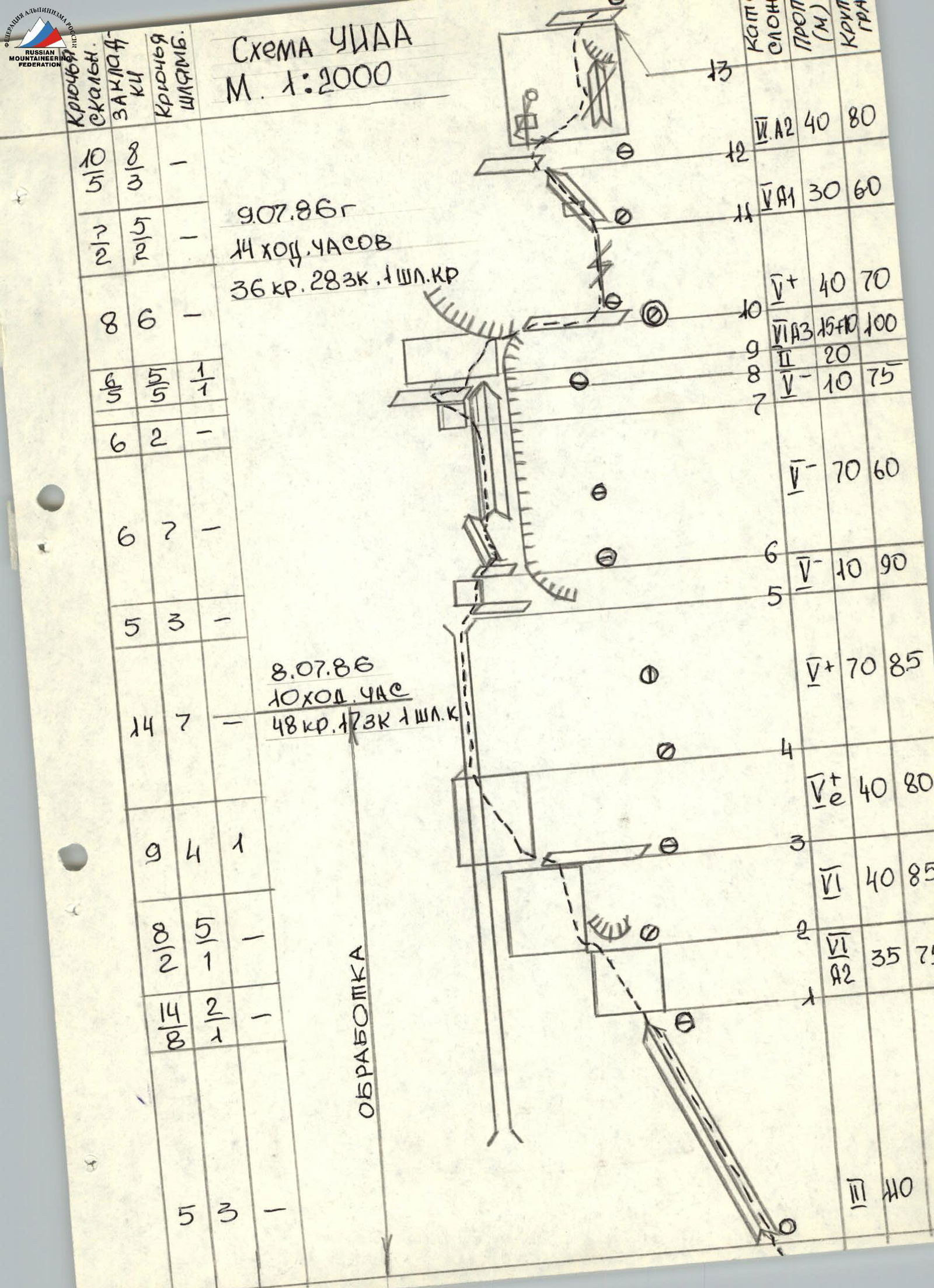
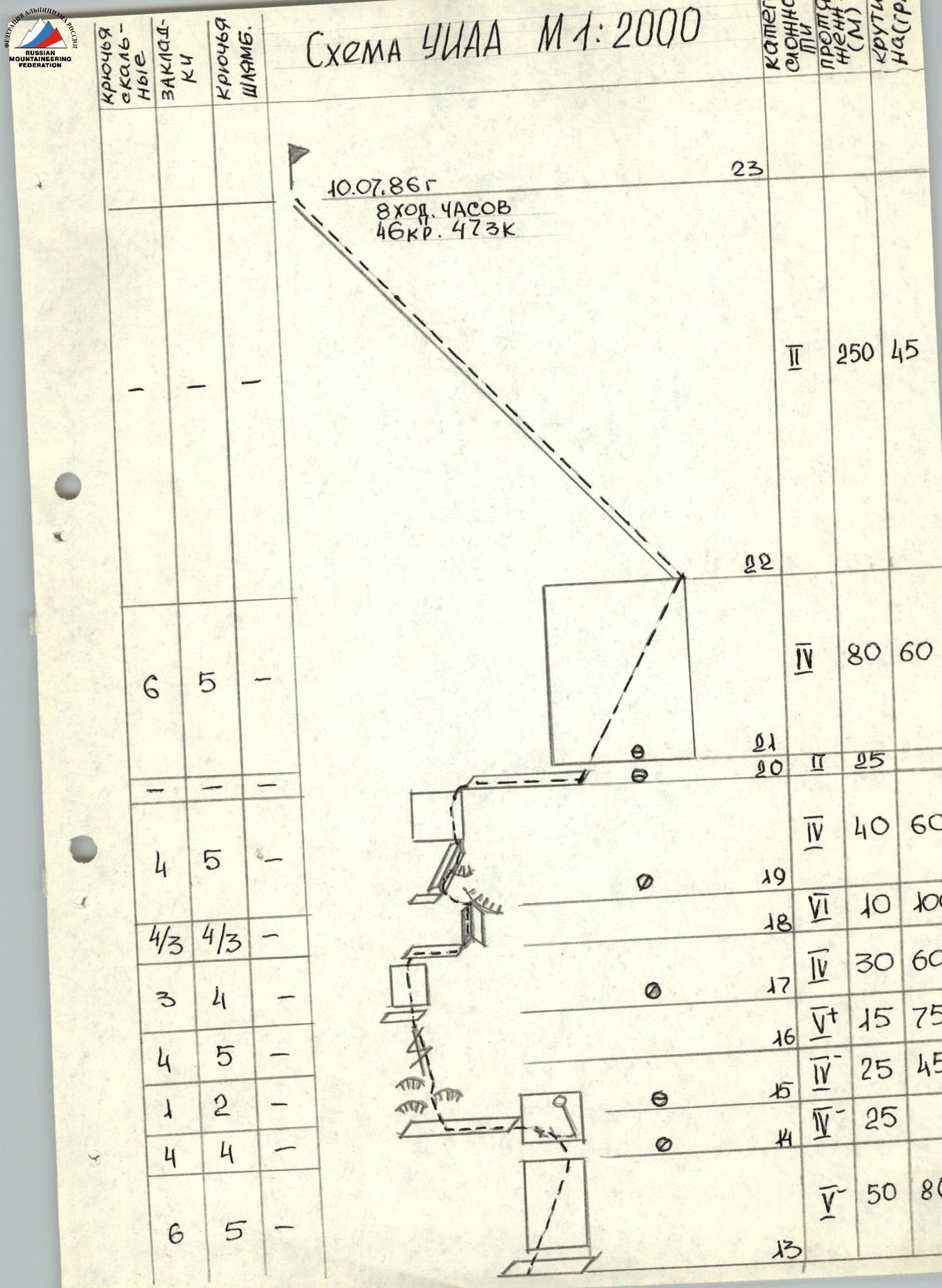
UIAA Scheme M 1:2000

Technical photo. Photo 5. Taken from the opposite slope (3800) on July 14, 1986, 15:00. Distance 2000 m.