Ascent Passport
- Ascent class: technical
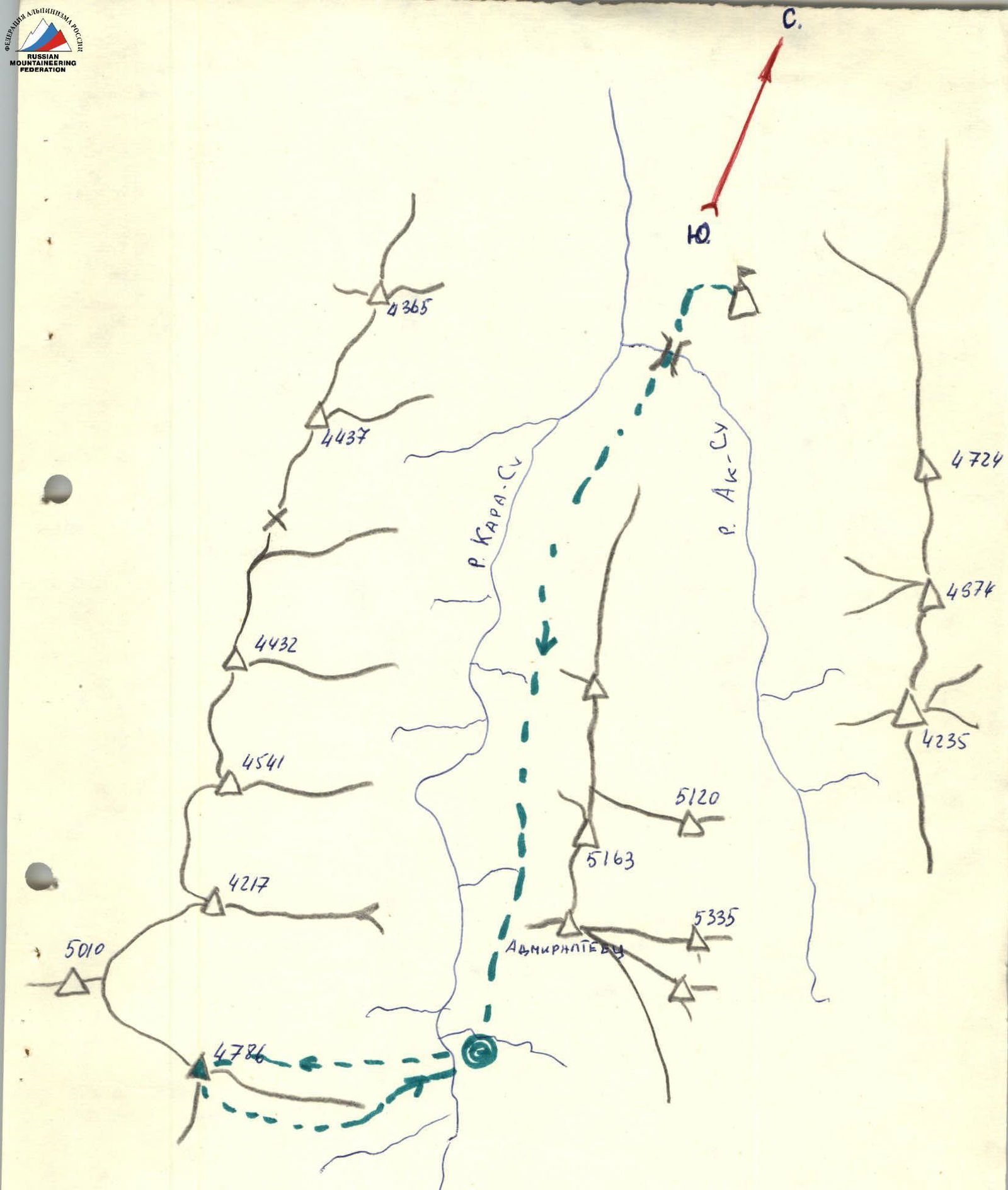
- Ascent area: Pamir-Alay (Kara-Su gorge)
- Ascent route: via the northern counterfort of the eastern ridge of peak "4786"
- Ascent characteristics: elevation gain — 1200 m, average slope — route: 44°, wall section: 85°, length — route: 1680 m, difficult section: 600 m
- Pitons driven: rock — 132, ice — none, bolt — none
- Total climbing hours: 31.5 hours
- Number of bivouacs: two, first — sitting on a ledge, second — comfortable on the ridge
- Team name: team MGS DSO "TRUD"
- Participants:
- Orlov V.F. — leader (1st sports category)
- Boronin N.V. — participant (Candidate for Master of Sports)
- Romanov S.B. — participant (1st sports category)
- Klochko V.A. — participant (1st sports category)
- Team coach: Nikolai Petrovich Krainov
- Dates — departure: July 17, 1983, return: July 19, 1983
MAP-SCHEME
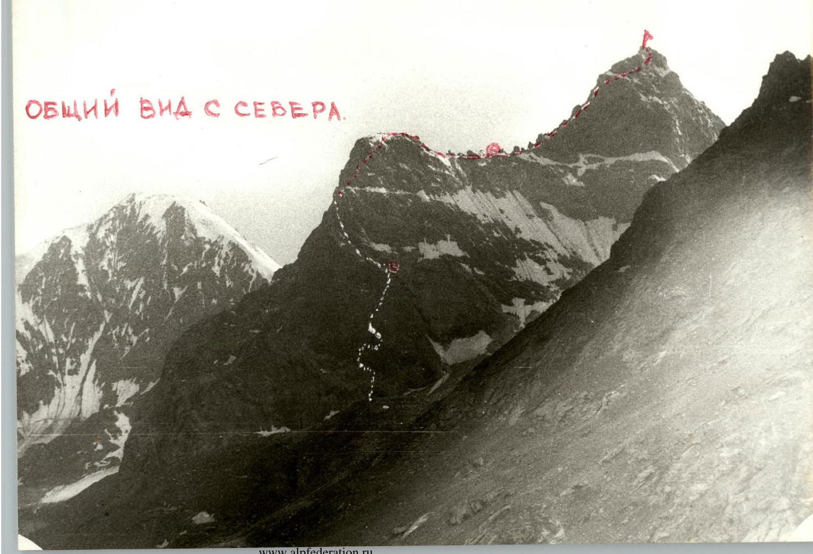
General view from the north
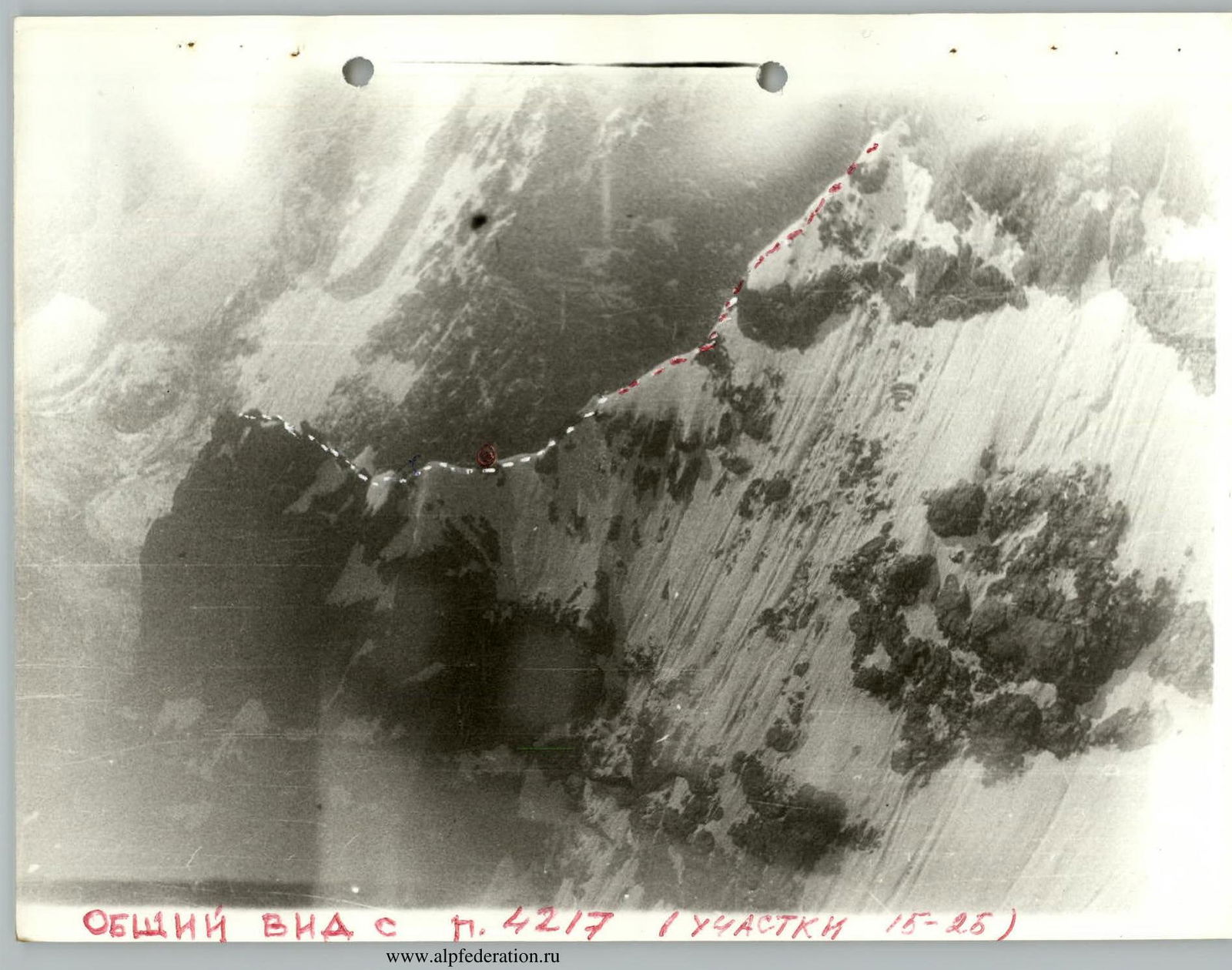
ROUTE SECTIONS TABLE
| dates | section | average slope of section | length of section | time | bivouacs |
|---|---|---|---|---|---|
| July 17, 1983 | R0–R1 | 40° | 10 m | 10:00 | |
| R1–R2 | 80° | 20 m | 10:15 | ||
| R2–R3 | 75° | 30 m | 11:00 | ||
| R3–R4 | 85° | 40 m | 12:00 | ||
| R4–R5 | 90° | 2.5 m | 12:30 | ||
| R5–R6 | 80° | 20 m | 13:15 | ||
| R6–R7 | 85° | 40 m | 14:10 | ||
| R7–R8 | 80° | 30 m | 17:50 | ||
| R8–R9 | 85° | 40 m | 19:30 | ||
| R9–R10 | 85° | 40 m | 21:00 | sitting | |
| July 18, 1983 | R10–R11 | 70° | 40 m | 9:00 | |
| R11–R12 | 50° | 120 m | 10:00 | ||
| R12–R13 | 65° | 160 m | 11:15 | ||
| R13–R14 | 70° | 60 m | 13:30 | ||
| R14–R15 | 75° | 30 m | 17:00 | ||
| R15–R16 | 60° | 40 m | 17:40 | ||
| R16–R17 | 10° | 80 m | 18:45 | ||
| R17–R18 | 85° | 25 m | 19:15 | ||
| R18–R19 | 15° | 280 m | 21:30 | comfortable | |
| July 19, 1983 | R19–R20 | 10° | 120 m | 8:30 | |
| R20–R21 | 85° | 40 m | 9:45 | ||
| R21–R22 | 65° | 20 m | 10:30 | ||
| R22–R23 | 50° | 200 m | 11:00 | ||
| R23–R24 | 80° | 20 m | 12:15 | ||
| R24–R25 | 40° | 80 m | 13:10 | summit | |
| descent started | 13:40 |
ROUTE SECTIONS TABLE (continued)
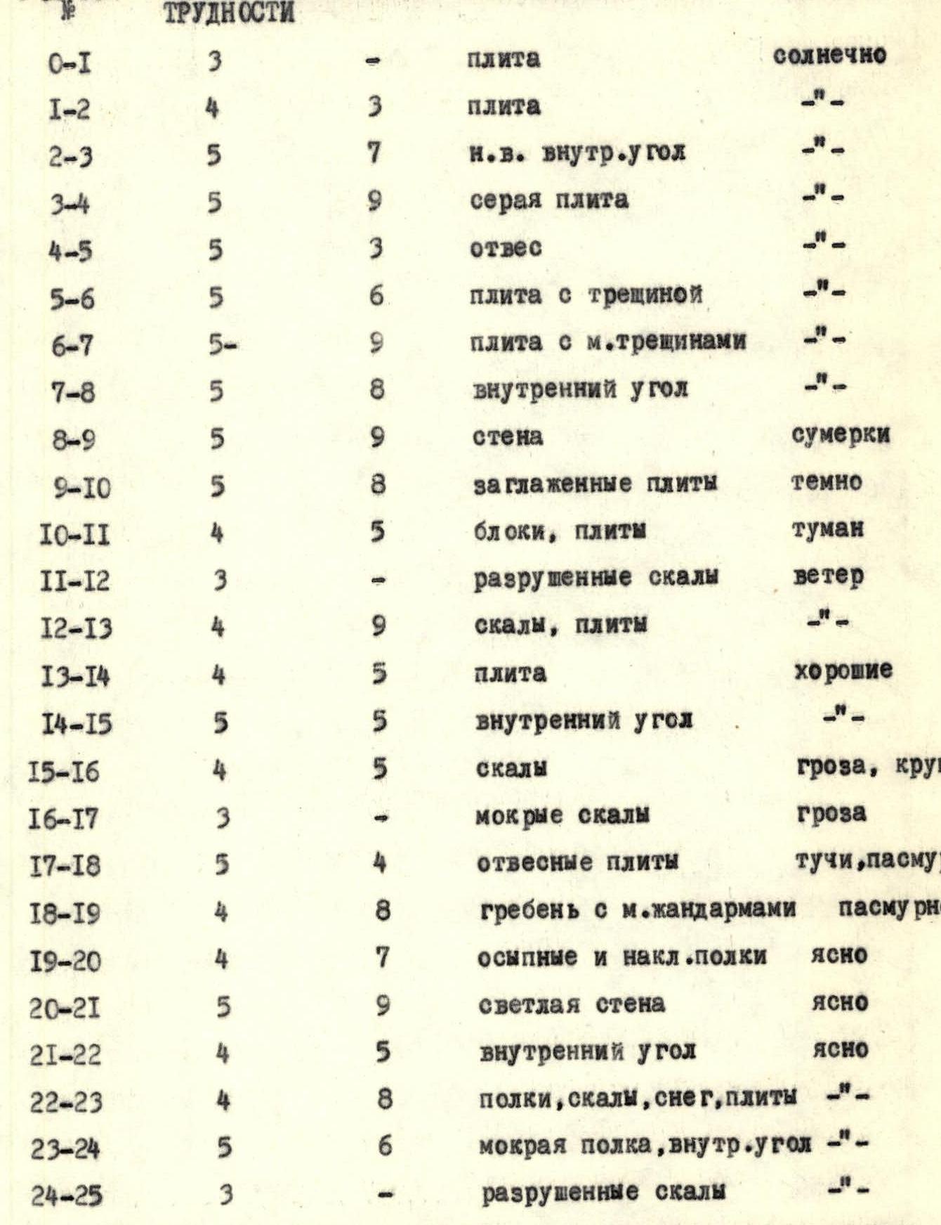
| SECTION | DIFFICULTY LEVEL | PITONS | RELIEF CHARACTER | WEATHER CONDITIONS |
|---|---|---|---|---|
| R0–R1 | 3 | – | slab | sunny |
| R1–R2 | 4 | 3 | slab | -"– |
| R2–R3 | 5 | 7 | inner corner | -"– |
| R3–R4 | 5 | 9 | gray slab | – |
| R4–R5 | 5 | 3 | sheer | -"– |
| R5–R6 | 5 | 6 | slab with crack | -"– |
| R6–R7 | 5 | 9 | slab with small cracks | -"– |
| R7–R8 | 5 | 8 | inner corner | -"– |
| R8–R9 | 5 | 9 | wall | dusk |
| R9–R10 | 5 | 8 | smooth slabs | dark |
| R10–R11 | 4 | 5 | blocks, slabs | fog |
| R11–R12 | 3 | – | broken rocks | wind |
| R12–R13 | 4 | 9 | rocks, slabs | -"– |
| R13–R14 | 4 | 5 | slab | good |
| R14–R15 | 5 | 5 | inner corner | -"– |
| R15–R16 | 4 | 5 | rocks | thunderstorm, sleet |
| R16–R17 | 3 | – | wet rocks | thunderstorm |
| R17–R18 | 5 | 4 | sheer slabs | clouds, overcast |
| R18–R19 | 4 | 8 | ridge with small pinnacles | overcast |
| R19–R20 | 4 | 7 | scree and sloping ledges | clear |
| R20–R21 | 5 | 9 | light wall | clear |
| R21–R22 | 4 | 5 | inner corner | clear |
| R22–R23 | 4 | 8 | ledges, rocks, snow, slabs | -"– |
| R23–R24 | 5 | 6 | wet ledge, inner corner | -"– |
| R24–R25 | 3 | – | broken rocks | -"– |
Descent was via broken rocks, exiting onto the glacier.
Route Description
First day. The northern counterfort resembles a vertical pillar with a reddish broken rock in the middle and a stone "finger" at the top. It is bounded on the right by a snow-ice couloir leading to the base of a ridge pinnacle, and on the left by drops into the gorge.
The route starts on a gray slab resembling a triangle with its apex pointing down.
- R0–R1 Up this 40° slab, 10 m to a ledge, where an initial cairn is built without a note (Зк.т.).
- R1–R2 Above the ledge is another gray slab in the shape of a triangle, but with its apex pointing up. Up the left side of the triangle (crack) — 20 m to its top (slab 80°, 3 pitons, 4th difficulty level).
- R2–R3 From the triangle's top, up and right along a pronounced inner corner, exiting after 30 m to a small ledge, with awkward protection (75°, 7 pitons, 5th difficulty level).
- R3–R4 Then 40 m left and up under an overhang and then along a red slab to a sloping ledge, where the first control cairn is located (85°, 9 pitons, 5th difficulty level).
- R4–R5 Before the sloping ledge, a sheer 2.5 m section (90°, 3 pitons, 5th difficulty level).
- R5–R6 From the ledge, traverse 20 m right and down along an 80° slab with a crack, bypassing an overhang to a sloping ledge (6 pitons, 5th difficulty level).
- R6–R7 Left and up along a slab with small cracks, 40 m, 85°, exiting to a ledge convenient for belaying (9 pitons, 5th difficulty level).
- R7–R8 From the ledge, 30 m up to an inner corner with a slope of 80° to a broken rock, with awkward belay points (8 pitons, 5th difficulty level).
- R8–R9 One rope length straight up the wall (85°, 9 pitons).
- R9–R10 40 m along smooth slabs at 85°, exiting to the shoulder of the counterfort (near the stone "finger"), with 8 pitons driven. The group bivouacked here. It's impossible to set up a tent, but 4 people can sit comfortably. There's snow and ice.
Second day.
- R10–R11 From the site, 40 m of climbing along the ridge of large blocks and slabs with an average slope of 70°, exiting to scree ledges before a pinnacle (5 pitons).
- R11–R12 120 m along broken rocks with a slope of 50° under the pinnacle's tower.
- R12–R13 Four rope lengths along rocks of 4th difficulty level, exiting to a ledge (65°, 9 pitons).
- R13–R14 60 m traverse left to an inner corner under an overhanging rock of the pinnacle, exiting to the pinnacle (5 pitons).
- R14–R15 30 m along a pronounced inner corner with a slope of 75°, with 5 pitons driven (5th difficulty level).
- R15–R16 40 m along rocks with a slope of 60° to the top of the pinnacle (5 pitons, 4th difficulty level).
- R16–R17 80 m along the ridge along the pinnacle's top. Caution! Snow cornices (3rd difficulty level).
- R17–R18 From the pinnacle, 25 m rappel to the ridge leading to the summit.
- R18–R19 A ridge section of the route with rock islands about 25–30 m high, approximately 4 km long. Total length 6–7 rope lengths, average slope of the ridge 15°. Before the penultimate pinnacle, shaped like a forked reddish rock, there's a bivouac site on ledges with snow.
Third day. R19–R20 After the bivouac, traverse the pinnacle on the left along ledges for 3 rope lengths, 5 km.
- R20–R21 40 m of climbing along a light wall with a slope of 85°, exiting to a convenient ledge for belaying (9 pitons, 5th difficulty level).
- R21–R22 20 m of climbing along an inner corner to a scree ledge (5 pitons).
- R22–R23 200 m along slabs, scree ledges, and snow under the final pre-summit ascent. Average slope 50° (8 pitons, 4th difficulty level).
- R23–R24 20 m overcoming a wet ledge under an overhang with a transition to an inner corner (80°, 6 pitons, 5th difficulty level).
- R24–R25 Along scree ledges and rock outcrops, we ascend to the summit of blocks of red rock stacked on top of each other. At the very summit, no more than three people can stand simultaneously.
Descent
Back along the ascent route for about 200 m to a ledge (before the ledge, a 30 m rappel). Then left and down, traversing:
- two ridges
- two couloirs with firm snow, 20–25 m wide
We exit onto a rock "staircase" between peaks "4786" and "4690" ("elephant"). Descent is by "sports" method. Then along the glacier and scree to abandoned stone huts (see "approaches"). The descent takes 4–5 hours.