
Ascent Passport
- Ascent class — technical.
- Ascent area — Pamir-Alay, Turkestan Range, Kara-Su gorge.
- Peak — p. 4690 (50 years of DSO “Spartak”), via N slope.
- Difficulty category — 4B (estimated).
- Route characteristics:
- snow-ice route
- height difference 750 m
- length 110 m
- ice section length 950 m
- section lengths: 5th diff. cat. — 80 m, 4th diff. cat. — 500 m, 3rd diff. cat. — 240 m.
- Average slope steepness on the ice section is 45°.
- Protection: rock pitons — none, ice screws — 75.
- Total climbing time:
- from bivouac to summit 8.5 hrs
- from summit to bivouac (descent) 3 hrs.
- Group members:
- Potapkov A. G. 2nd sports category
- Titov S. N. 2nd sports category
- Coach: Gladchenko V. I. Candidate Master of Sports
- Departure dates:
- August 20, 1984 — from base camp to bivouac under the summit
- August 21, 1984 — ascent and return to base camp.
p. 4690
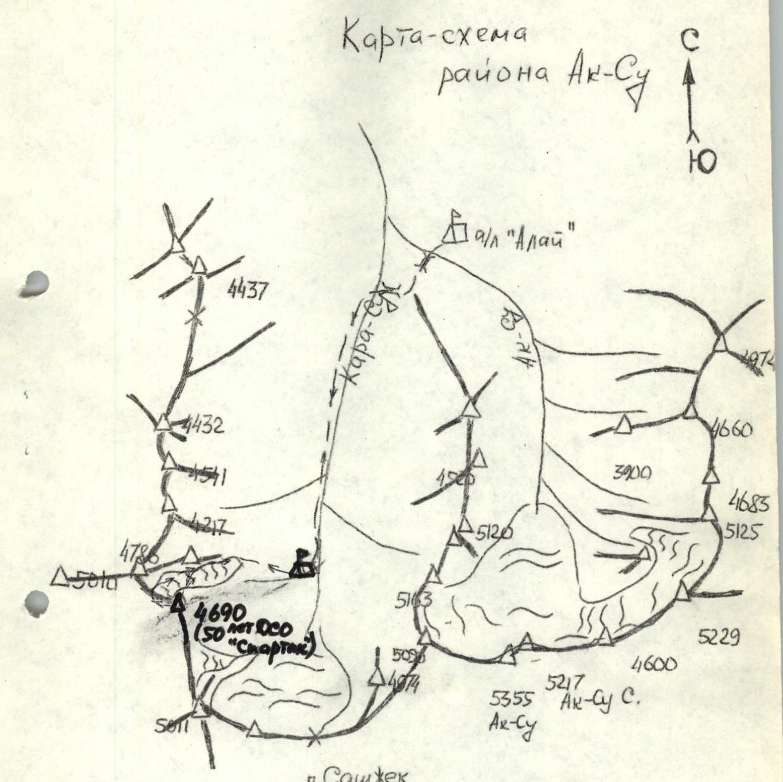
Ak-Su area map
Route description
From the base camp at the confluence of the Ak-Su and Kara-Su rivers, cross the bridge in the Kara-Su gorge and continue along the trail on the left (orogr.) bank of the Kara-Su River to the upper part of the gorge below p. 4786. Here, by a stream flowing from the glacier between p. 4690 and p. 4786, is the bivouac site. From the camp — 3–3.5 hrs.
From the bivouac, follow the left (orogr.) moraine straight up along the stream to the rocky shoulder of p. 4786. Climb 30 m up the shoulder (belay!) and then continue up a large scree slope to the upper cirque of the glacier between p. 4786 and p. 4690. Traverse the glacier left-upwards to the base of the northern ice slope. From the bivouac — 1.5–2 hrs.
The beginning of the route contains the steepest section. It goes straight up the ice slope to the shoulder of p. 4690, where a cairn marks the route. From the start of the route — 5 hrs.
From the cairn, follow the ridge of the snow-ice slope under the ice fall and then continue up a simple snow slope to a broken rocky ridge. Follow the ridge 160 m to the summit. From the cairn — 1.5 hrs.
The descent begins by retracing the ascent route to the saddle in the ridge (20 min), then continue left-down along the broken north-west ridge on scree, and exit onto a col between p. 4690 and p. 4786.
From the col:
- descend to the glacier. From the summit — 1 hr.
- traverse the glacier left-down to the rocky shoulder of p. 4786 (here a 30 m rappel)
- continue down the moraine to the bivouac. From the summit — 3 hrs.
The return to the base camp along the trail on the left bank of the Kara-Su River takes 2–3 hrs.
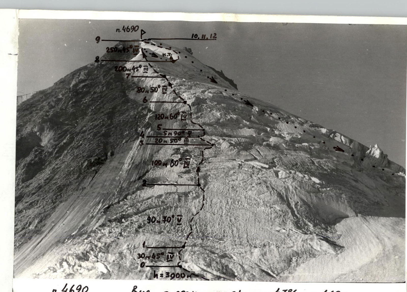

ASCENT ROUTE CHARACTERISTICS TABLE
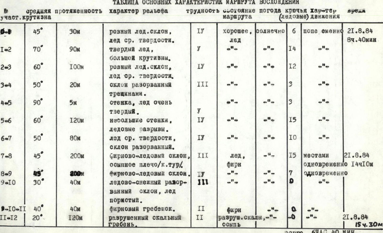
Table explanations
R0–R1. Ice slope mostly without crevasses, climbing straight up, belay via ice screws. Ice axes or “ice fifis” required.
R1–R2. Steep even ice slope, belay via ice screws.
R2–R3. Climbing the ice slope left-upwards, bypassing small crevasses.
R3–R4. Bypass a large crevasse and exit below a 5 m wall.
R4–R5. Vertical 5 m ice wall. The first climber uses “ice fifis”, the second follows on jumars on the rope.
R5–R6. Traverse left to bypass a crevasse, then straight up, overcoming small (1.5–2 m) ice walls. Alternating movement, belay via ice screws.
R7–R8. Firn-ice slope, with snow in the upper part. Climbing straight up, in the upper part simultaneously. Exit onto the shoulder — a cairn marks the route. From the start of the route — 5 hrs 30 min.
R8–R9. Snow-ice slope. Belay via ice screws, in the upper part via ice axe.
R9–R10. Slope broken by crevasses. Traverse left under the slope failure to an ice bridge, then 40 m straight up.
R10–R11. Simple firn slope. Simultaneous movement to the broken rocky ridge.
R11–R12. Simultaneous movement along the broken rocky ridge to the summit. From the cairn — 1.5 hrs.