
Climbing Passport
I. Climbing category — technical
- Climbing area — Pamir-Alay, Turkestan Range, Jetykuprek gorge (Layla district) — Kara-Su
- Peak — 4690 m (50th anniversary of Moscow "Spartak" via the North icy slope)
- Proposed difficulty category — 4B (first ascent)
- Route characteristics:
- route is snow-ice
- height difference — 740 m
- length — 1100 m
- ice part length — 950 m
- length of sections with I difficulty category — 80 m, IV difficulty category — 560 m, III difficulty category — 230 m
- average steepness of icy part — 45°
- Pitons hammered for protection: rock — none, ice screws — 90 pieces
- Number of climbing hours — 9 hours
- Group composition: Kavunenko V.D. — Master of Sports of International Class, leader Shidlovsky S.V. — Candidate for Master of Sports Ovsyannikov V.A. — Candidate for Master of Sports Filippov D.A. — Candidate for Master of Sports Kizikov A.N. — 1st sports category Batalin V.G. — 2nd sports category Kavunenko I.V. — 2nd sports category
- Coach: Kavunenko V.D. — Master of Sports of International Class
- Date of departure and return: August 16, 1984
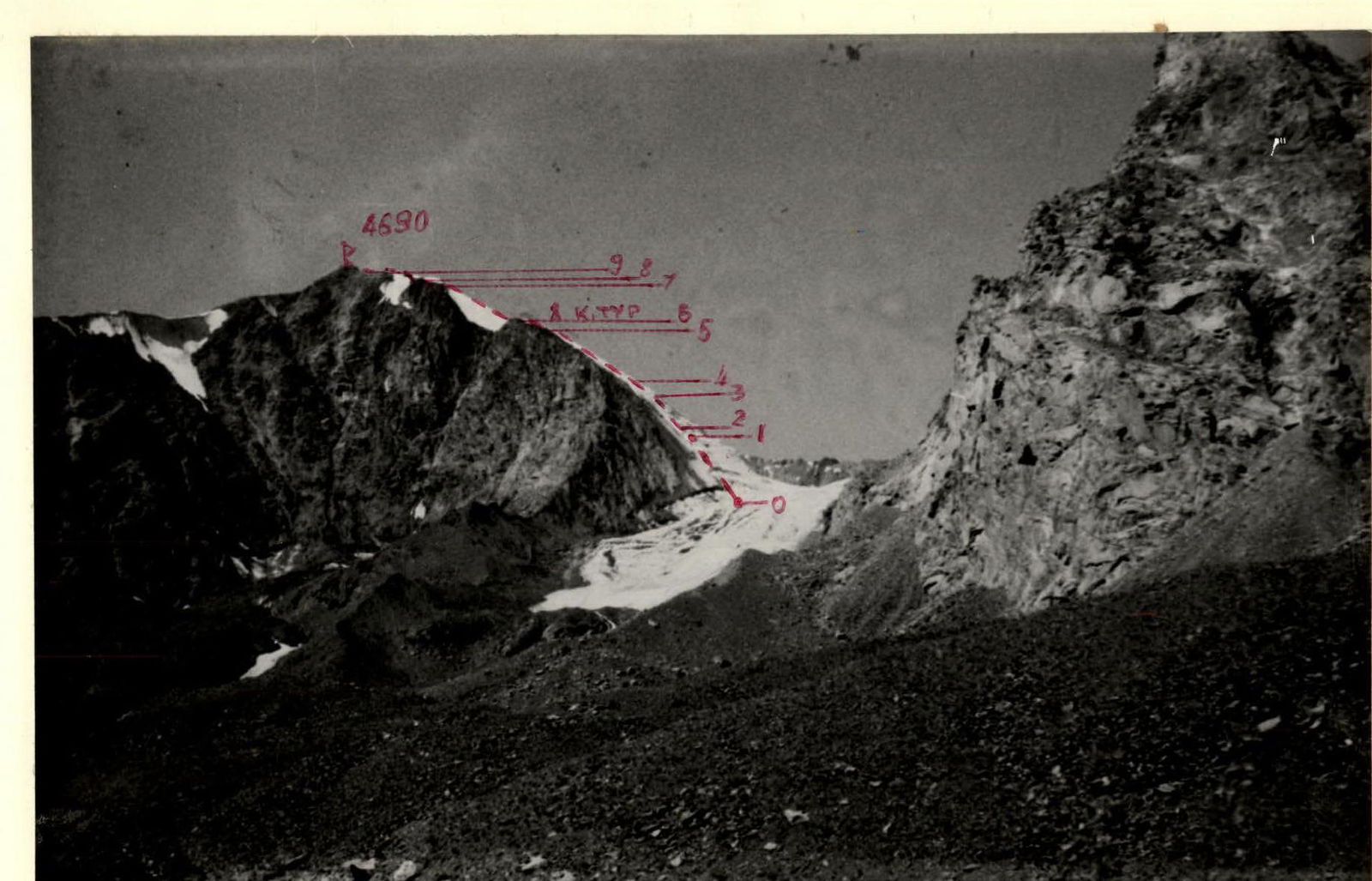
General view of the peak from the Kara-Su gorge
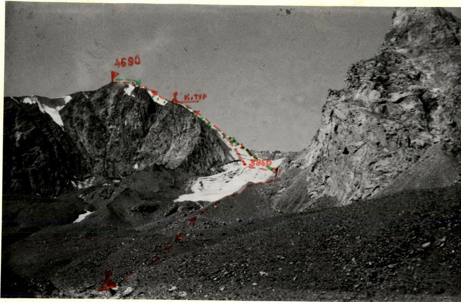 From the base camp at the confluence of the Ak-Su and Kara-Su rivers, across the bridge in the Kara-Su gorge and further along the trail on the right (orogr.) bank of the Kara-Su river to the abandoned summer pastures near the glacier in the upper reaches of the river. Crossing the moraines of the glacier to the right — approach to the bastion of peak 4786. Here, near the stream flowing from the glacier between peaks 4690 and 4786 — bivouac. From the camp — 4.5 hours.
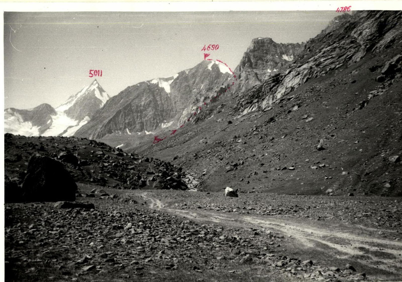
From the bivouac along the left (orogr.) moraine straight up, along the stream to the rocky shoulder of peak 4786. Up the rocky shoulder (protection, pitons) 30 m and further along the large scree — exit to the upper circus of the glacier between peaks 4690 and 4786. Crossing the glacier to the left-up — exit to the base of the North icy slope. Start of the route. From the bivouac — 1.5–2 hours.
From the start of the route straight up, to the right of the icy ridge, along the icy slope — exit to the shoulder of peak 4690, here is the control cairn. From the start of the route — 6 hours. Detailed description is given in the table of route characteristics and explanations to the table, sections R0–R6.
From the control cairn along the ridge of the firn-ice slope under the icy ledge and further along the simple icy slope — exit to the destroyed rocky ridge. Along the ridge 150 m — exit to the summit. From the control cairn — 3 hours. Description see table — sections R7–R10.
Descent from the summit along the ascent route 100 m to the saddle of the ridge (20 min). Further to the left-down, along the scree couloir, along the destroyed C-3 ridge — exit to the saddle to peak 4786. From the saddle — down to the glacier. From the summit — 1 hour.
Along the glacier to the left to the rocky shoulder of peak 4786 (here 30 m of sport climbing) and further along the moraine to the bivouac. From the summit — 2.5 hours.
Return to the base camp along the trail on the left bank of the Kara-Su gorge.

Photopanorama from the Kara-Su gorge
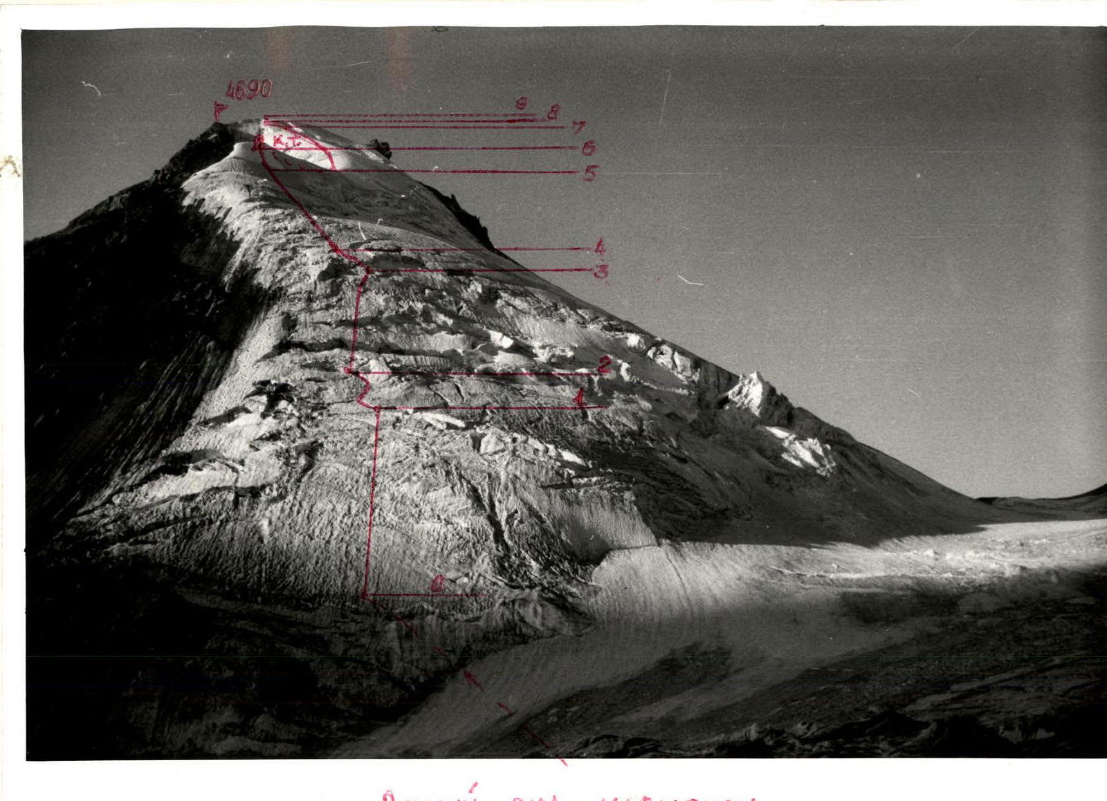
General view of the route from the glacier under the peak
Route profile

Section R2–R3
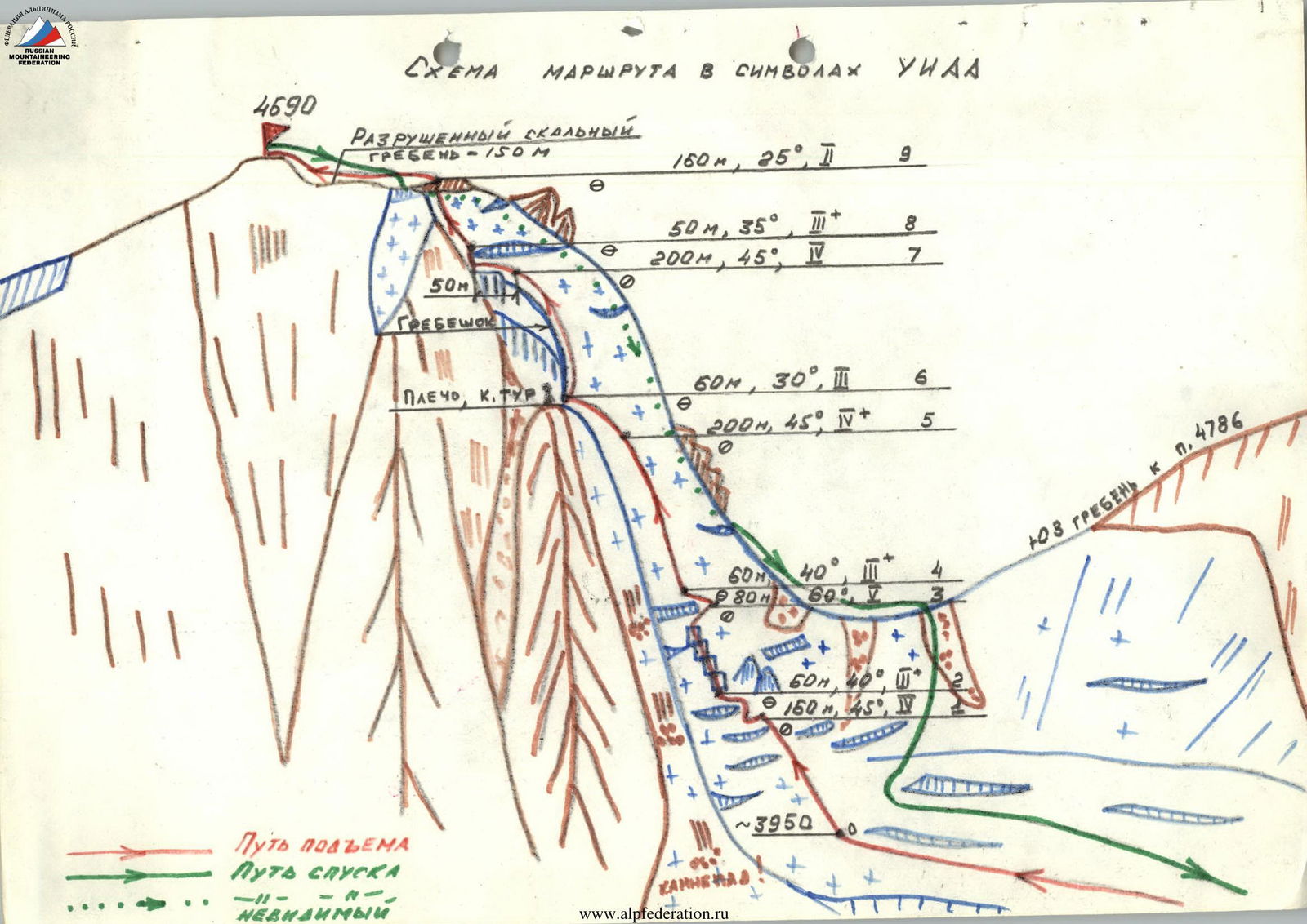
Route scheme in UIAA symbols
Destroyed rocky ridge (150 m)
- R9: 160 m, 25°, 2
- R8: 50 m, 35°, 3+
- R7: 200 m, 45°, 4
Ridge (Shoulder, Control Cairn)
- R6: 60 m, 30°, 2
- R5: 200 m, 45°, 4+
Ascent sections
- R4: 60 m, 40°, 2
- R3: 80 m, 80°, 5
- R2: 60 m, 40°, 2
- R1: 160 m, 45°, 4
Cainenaad
- R0: ~3950 m (start of the route)
Table of main route characteristics
| № | Average steepness | Length, m | Relief character | Difficulty category | Route condition | Weather conditions | Pitons (rock) | Pitons (ice screws) | Movement character | Date, time, hours |
|---|---|---|---|---|---|---|---|---|---|---|
| R0–R1 | 45° | 160 | Icy slope, even. Ice of medium hardness | 4 | good, ice | sunny | – | 15 | alternating "perila" | September 16, 1984 8:00, 8 hours |
| R1–R2 | 40° | 60 | Icy slope, broken, open crevasses | 3 | good, ice | —" | – | 8 | —" | |
| R2–R3 | 60° | 80 | Icy walls 4–6 m high, icy slope | 5 | good, ice | —" | – | 20 | — 4 | |
| R3–R4 | 40° | 60 | Traverse of icy slope, porous ice | 3 | good, ice, firn | —" | – | 6 | alternating | |
| R4–R5 | 45° | 200 | Icy slope, even, ice of medium hardness | 4 | good, ice, firn | —" | – | 20 | alternating "perila" | |
| R5–R6 | 30° | 60 | Firn-icy slope, scree shoulder. Control cairn. | 3 | good, ice, firn | —" | – | 3 | alternating | September 16, 1984 14:30, 6.5 hours |
| R6–R7 | 45° | 200 | Firn-icy slope | 4 | good, firn, ice | —" | – | 15 | alternating "perila" | |
| R7–R8 | 35° | 50 | Icy slope, broken. Ice of medium hardness. | 3+ | good, ice | —" | – | 3 | alternating | |
| R8–R9 | 25° | 160 | Icy slope. Porous ice. | 2 | good, ice | —" | – | – | simultaneous | |
| R9–R10 | 15° | 150 | Destroyed rocky ridge | 2 | destroyed rocks, scree | —" | – | – | simultaneous | September 16, 1984 12:00 |
| Total: | 9 hours |
Brief explanations to the table
R0–R1. Icy slope, mostly without crevasses. Movement straight up. Protection through ice screws. The first one goes on ice axes or "ice fifis", the rest — on a fixed rope.
R1–R2. Icy slope, heavily broken. Movement in an oblique traverse to the right-left, bypassing crevasses, along ice bridges. Do not go to the left of the icy ridge — ROCKFALL HAZARD! Protection through ice screws.
R2–R3. System of short icy walls on a steep icy slope, crevasses. Movement straight up. Protection through ice screws. The first one goes on ice axes or "ice fifis", the rest — on a fixed rope.
R3–R4. Ice-firn slope. Oblique traverse under the ascent to the left. Protection through ice screws. Alternating movement.
R4–R5. Icy slope, местами firn. Protection through ice screws. The first one goes on ice axes, the rest on a fixed rope. Movement straight up.
R5–R6. Firn-icy slope. Protection through ice screws and ice axe. Movement to the left-up to the scree shoulder, alternating. On the shoulder — control cairn. From the start of the route — 6 hours.
R6–R7. Firn-icy slope, with snow in the upper part. Narrow transverse crevasses, filled with snow. Protection through ice screws, in the upper part — through an ice axe stuck in the crevasses. Movement straight up, alternating, to the middle of the section on a fixed rope.
R7–R8. Broken icy slope. Traverse to the left under a large icy ledge to an ice bridge, further 50 m straight up. Piton protection.
R8–R9. Simple icy slope. Movement straight up, simultaneous, to the destroyed rocky ridge.
R9–R10. Heavily destroyed rocky ridge. Simultaneous movement.