I. Category — technical
2. Pamiro-Alai, Turkestan Range, Kara-Su gorge, Leylyak gorge
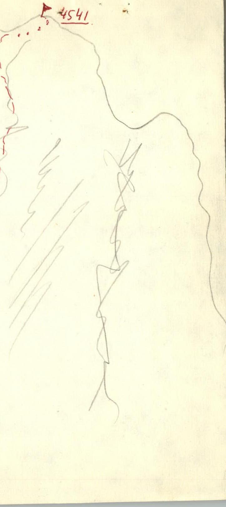
3. Peak 4541 via the Eastern ridge
4. Assumed 46 40 category first ascent
5. Height difference 850 m. Total length 1480 m. Length of sections IV — 450 m
6. Average slope of the route 60°
7. Average slope of the key section 75°
8. 65 pitons driven
Of which 23 for organization of reception areas
9. Climbing hours — 12
10. Overnight stays on the route are possible
II. Group composition: Boronin N.V. 1st sports category — leader
Bogdanov V.I. — CMS — participant
Orlov V.F. — 1st sports category — participant
Romanov S.B. — 1st sports category — participant
12. Coach — Kraynov Nikolay Petrovich
13. Approach to the route July 12, 1983
Peak 4541 July 12, 1983
Return July 12, 1983
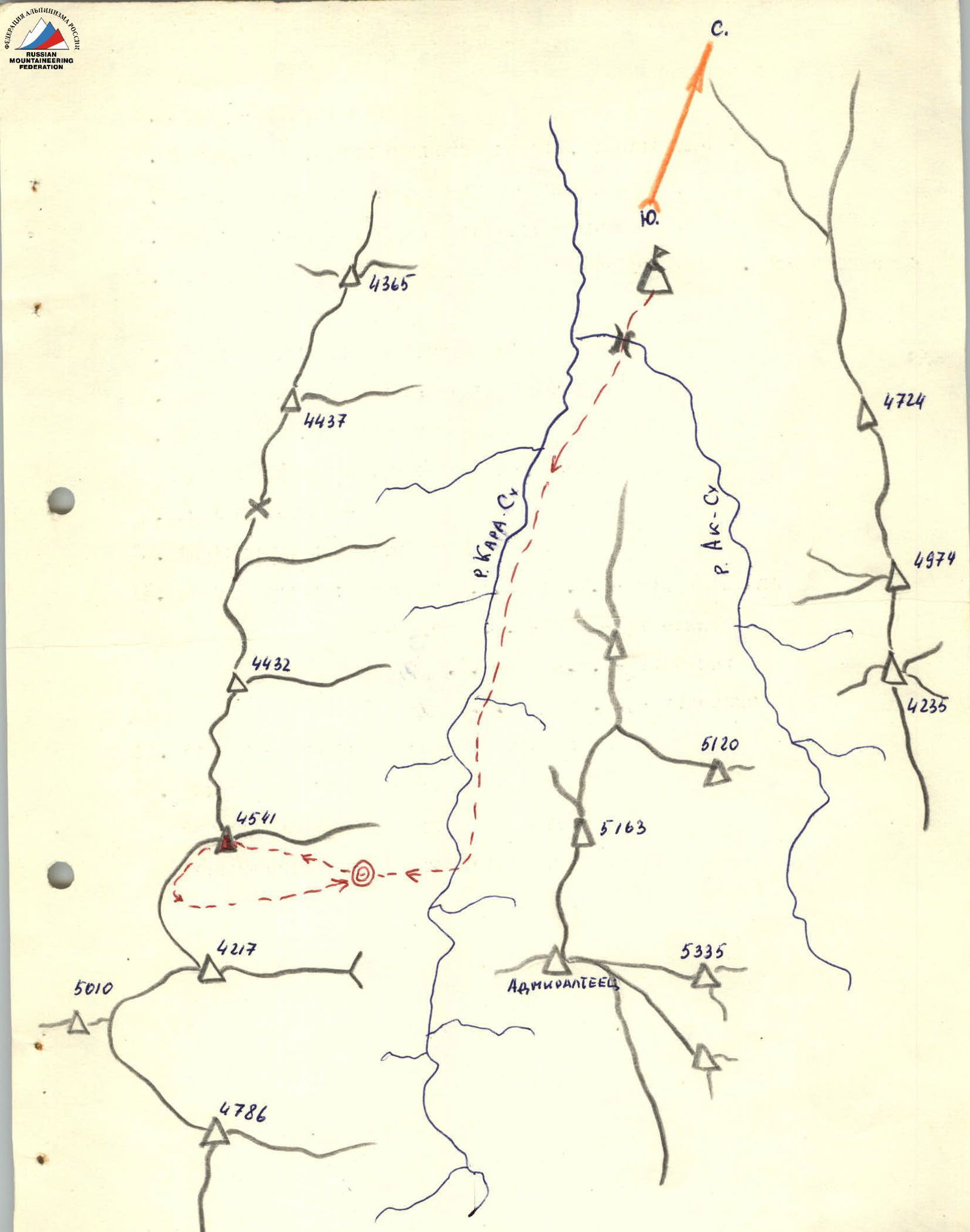
MAP-SCHEME
DESCRIPTION OF THE ROUTE
to peak 4541 via the Eastern ridge
0–1 From the overnight stay in the cirque between peaks 4541 and 4217 (altitude about 3700 m) along the scree and snowy slope 30–40° we approach the beginning of the ridge in the upper visible part, where the break-off is emphasized by white stripes. To the left of the ridge — "ram's foreheads" with a stream, to the right — a gray wall, further to the right — a vertical, wet wide crack to the top 700 m. 1 hour walking on pre-made steps in the snow. We approach the rocks with dark streaks.
- 1–2: Rocks with dark streaks are overcome using 2 pitons, 1 rope 2 cat. diff. (do not bypass via the stream with "ram's foreheads", stones fall).
- 2–3: 3 ropes of rocks like "ram's foreheads", interspersed with ledges 2 cat. diff. 40°, we pass simultaneously.
- 3–4: 1.5 ropes of slabs with steepness up to 70° height 3–4 m with small ledges, convenient for belays, 2 pitons 3 cat. diff., lead to a wide platform under the rocky tower.
- 4–5: Overcoming 0.5 ropes up the slab to the left, you get into rocks with a plug (65°, 5 pitons 4 cat. diff.).
- 5–6: Having passed the chimney with a plug (10 m, 75°, 3 pitons), we come to a broken-off stone.
- 6–7: From the break-off 30 m along the slab with a crack of complex climbing (80°, 5 cat. diff., 6 pitons, chockstone). Further 20 m under the rocky overhangs along the inner
- 7–8: corner (75°, 5 cat. diff., 7 pitons). In the inner corner, a few meters from the overhang (at the level of white slabs) — a control cairn (a can, nailed with a piton).
- We were at the cairn at 12:00.
- 8–9: Bypassing the overhang to the left upwards along the slabs 70°, alternating with ledges and inner corners 50 m, climbing 3 cat. diff., 5 pitons. Exit to an inclined slab.
- 9–10: Along the inclined slab with cracks (1 rope, 50°, 4 cat. diff., 4 pitons) we exit to the ridge of the eastern rib.
- 10–11: 2 ropes along the ridge 40° simultaneously, belay from the relief above the S.E. ridge slope to the scree ledge. Overnight stay is possible, there is water.
- 11–12: From the ledge to the right upwards through the inner corner 50°, 30 m to a small ledge, 4 cat. diff., 4 pitons.
- 12–13: From the small ledge to the right upwards traverse of a large slab 60° bypassing the overhanging rock (pre-summit tower), 1 rope, 7 pitons, 4 cat. diff.
- 13–14: Further up to the left along the slabs 65°, 2 ropes under the summit tower, 8 pitons, 4 cat. diff.
- 14–15: We bypass the summit tower to the left (slabs, ledges), 1 rope, 5 pitons, 60°, 4 cat. diff.
- 15–16: Further through the wet crack with a plug (1 rope, 6 pitons) we exit to the ridge leading to the summit 4 cat. diff.
- 16–17: Along the ridge 50 m to the summit simultaneously, belay from protrusions, 45°, 3 cat. diff.
We were on the summit at 17:00.
Descent towards the ridge leading to peak 4217, 80 m from peak 4541, rappel 30 m to the saddle between 4541 and the gendarme. Pitons were driven, a loop of rope was left. Further, traversing the gendarme to the left along the destroyed rocks and scree ledges, we descend into the upper cirque. Before exiting to the scree — a 20 m sport rappel. Further along the scree through the snowfields to the narrowing of the cirque. Caution! "Ram's foreheads" in the gorge. Cross to the right in the narrow place along the way. We descend along the rocks, then along the snowy slope to the overnight stay site. We were at the overnight stay site at 20:00.
Path to the camp at the confluence of the Kara-Su and Ak-Su rivers. Along the slopes along the stream to the Kara-Su river. Crossing near the large stones, further along the right bank, passing 2 gullies to the camp — 2 hours 30 minutes.
SCHEME
- 0–1, 700 m, 40°, 2
- 1–2, 40 m, 60°, 2, R1
- 2–3, 100 m, 40°, 2
- 3–4, 60 m, 70°, 3, R2–3
- 4–5, 20 m, 65°, 4, R4
- 5–6, 10 m, 75°, 5, R5
- 6–7, 30 m, 80°, 5, R6
- 7–8, 20 m, 75°, 5, R7
- 8–9, 50 m, 70°, 3, R8
- 9–10, 40 m, 50°, 4, R9–10
- 10–11, 80 m, 40°, 2
- 11–12, 30 m, 50°, 4, R12
- 12–13, 40 m, 60°, 4, R12–13
- 13–14, 80 m, 65°, 4, R14–15
- 14–15, 40 m, 60°, 4, R16
- 15–16, 40 m, 70°, 4, R17
- 16–17, 50 m, 50°, 3, R18
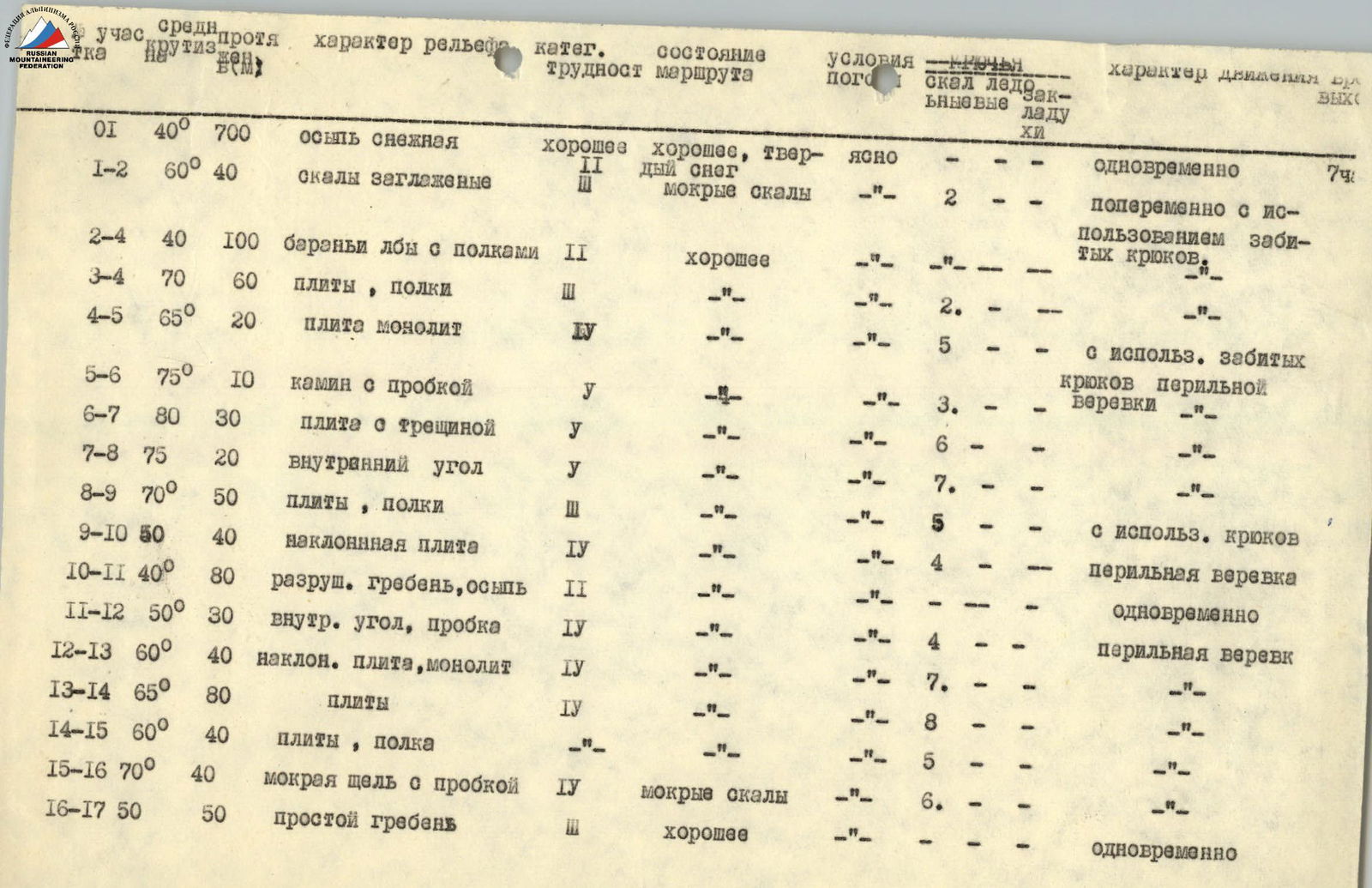
| Section | Average steepness | Length | Terrain characteristics | Cat. diff. | Condition | Weather conditions | Presence of rock/ice sections | Movement characteristics |
|---|---|---|---|---|---|---|---|---|
| 0–1 | 40° | 700 m | scree snowy | 2 | good | clear | – | simultaneously |
| 1–2 | 60° | 40 m | rocks smooth | 2 | wet rocks | – | 2 | alternately using driven pitons |
| 2–4 | 40° | 100 m | "ram's foreheads" with ledges | 2 | good | – | – | – |
| 3–4 | 70° | 60 m | slabs, ledges | 3 | – | – | – | – |
| 4–5 | 65° | 20 m | slab monolithic | 4 | – | – | 5 | – |
| 5–6 | 75° | 10 m | chimney with a plug | 5 | – | – | 3 | – |
| 6–7 | 80° | 30 m | slab with a crack | 5 | – | – | 6 | – |
| 7–8 | 75° | 20 m | inner corner | 5 | – | – | 7 | – |
| 8–9 | 70° | 50 m | slabs, ledges | 3 | – | – | 5 | – |
| 9–10 | 50° | 40 m | inclined slab | 4 | – | – | 4 | using pitons, fixed rope |
| 10–11 | 40° | 80 m | destroyed ridge, scree | 2 | – | – | – | simultaneously |
| 11–12 | 50° | 30 m | inner corner, plug | 4 | – | – | 4 | – |
| 12–13 | 60° | 40 m | inclined slab, monolithic | 4 | – | – | 7 | fixed rope |
| 13–14 | 65° | 80 m | slabs | 4 | – | – | 8 | – |
| 14–15 | 60° | 40 m | slabs, ledge | 4 | – | – | 5 | – |
| 15–16 | 70° | 40 m | wet crack with a plug | 4 | wet rocks | – | 6 | – |
| 16–17 | 50° | 50 m | simple ridge | 3 | good | – | – | simultaneously |