PASSPORT
- Technical class.
- Pamir-Alay, Turkestan Ridge, Karasu gorge.
- Petrovgradets (5163 m) via the Eastern ridge.
- Second ascent, 5B cat. sl. is assumed.
- The length of sections with 6–5B cat. sl. is about 300 m, 5A cat. sl. is about 450 m. The average steepness of the main sections is 80–90° (4800–4900), 70–80° (4900–5000), all of them are 5–6 cat. sl.
- Pitons hammered: rock, drilled, chocks, ice — 29, 27, 38.
- Travel hours — 27, days — 3.
- Two nights in a tent on the ledges.
- Team leader — Prokofiev Sergey Konstantinovich, 1st sports category. Participants — Petrichenko Nikolay Nikolayevich, USSR Master of Sports; Pokhil Boris Petrovich, Candidate for Master of Sports; Rybalka Konstantin Pavlovich, USSR Master of Sports.
- Team coach — Petrichenko Nikolay Nikolayevich, USSR Master of Sports.
- Approach to the route on June 23, 1984.
On the summit on June 25, 1984. Descent on June 26, 1984.

Photo 1. View of Petrovgradets from the southwest wall of Iskander peak. Shooting point φ1 on June 28, 1984, 11:30, H = 4200 m, U-50.
Team Tactics
The ascent route can be divided into three sections. The lower section up to the saddle is a steep snow-ice slope with a wide gully in the upper half, formed by the Northeast wall of Petrovgradets and rock ribs descending from the saddle. The ice steepness in the lower part is 35–45°, and in the gully up to 55°.
The middle section of the route is a rock wall of the wide Eastern ridge. The wall is about 350 m long and has several sheer sections.
The last third section of the route, about 300 m long, passes along a gradually flattening snow ridge with rock outcrops.
The most challenging sections are:
- the ice gully in front of the saddle (about 400 m);
- the rock wall of the Eastern ridge after the saddle.
Lying bivouacs with a tent are possible:
- in the second bergschrund of the ice slope;
- on rock outcrops to the left of the ice gully;
- on a rock ledge after the saddle (70–80 m after the rappel from the saddle);
- on the summit.
Movement schedule. Our group ascended the ice slope to the saddle in 16 hours and spent 2 hours descending from the saddle and moving to a ledge for a bivouac. With snow present, the ascent to the saddle may be slightly faster. From the night's halt on the ledge to the summit: 7–8 hours. Descent from the summit: 3 hours. Descent via a new route to the Aksu gorge: about 7 hours.
Tactical movement scheme. On the ice section, the first climber needs to have an ice-axe and an ice hammer. Belay via ice screws. All participants need crampons.
The second bergschrund with a snow-ice wall is ascended using ice axes. The rock wall of the Eastern ridge has several challenging sections that may require ladders.
It's better to proceed as follows:
- The first climber — lightly equipped and wearing galoshes;
- The rest — with a ladder and a prusik cord.
Communication with the base camp via "Vitalka" radio is quite reliable if the base correspondent moves to the triangulation point beyond the Karasu River.
Descent via the ascent route is impractical due to its great length (about 30 rappels and sport descents).
From the night's halt under the rock wall of the Eastern ridge, it's better to descend into the Aksu gorge. From the bivouac:
- 6 rappels down the sheer sections are required.
During the descent:
- stay near the counterfort and avoid the couloirs descending from the saddle, as the lower parts of the couloirs may have falling ice and rocks;
- be cautious during the fourth rappel, which ends in a hanging inner corner.
The sixth rappel will lead to a wide (about 100 m) gentle couloir bordering the southern wall of Petrovgradets. Down the couloir, it's logical to descend along the wall of Petrovgradets to the glacier plateau (the last 40 m are better descended as a sport descent).
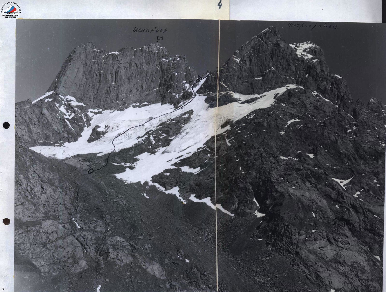
PHOTO 4. Panorama from the left slope of the Karasu gorge. Shooting point: June 22, 1984, 18:00, H = 3000 m. Lens I-24 (105 mm).
| Quantity | Section description |
|---|---|
| R14 ~250 m II–III | |
| 2 - 1 - | R13 40 m 55° IV⁻ |
| 1 - 3 - | R12 40 m 75° V⁻ |
| 3 - 3 - | R11 40 m 75° V⁺ |
| 1 - 3 - | R10 40 m 55° V⁻ |
| 5 - 5 - | R9 40 m 90° VI₂ VI⁻ |
| R8 25 m 15 | |
| 3 - 4 - | R7 40 m 80° V⁺ |
| R6 40 m 40° 11 | |
| R5 80 m 65° V⁻ |
Brief description of the route by sections
The approach to the Karasu gorge along the trail to the stream flowing from the glacier under the western slopes of Iskander and Petrovgradets peaks takes 2.5 hours. Another 1–1.5 hours are needed to ascend to the glacier tongue.
Section R0. At the base of the rock island, we cross the gully and exit onto the back of the ice counterfort. It's better to tie in on the scree slope, as after 50–60 m, belay on ice will be required. The ice is very hard, and despite moderate steepness, piton belay is necessary.
Section R1. Snow slope 100 m long between bergschrunds.
Section R2. Slope of the ice gully with rock islands. Bypassing three rock islands on the right, move towards rock outcrops. The first climber should preferably use an ice-axe, otherwise, twice as many ice screws will be needed. On the rocks, it's more convenient to organize belay on small ledges. Down the gully to the left of the route, small avalanches occur constantly. On snow-covered ledges of the rock rib, areas for a tent can be found.
Section R3. Similar to section R2. Steep ice alternates with rocks. It's better to move along the edge of ice and rocks.
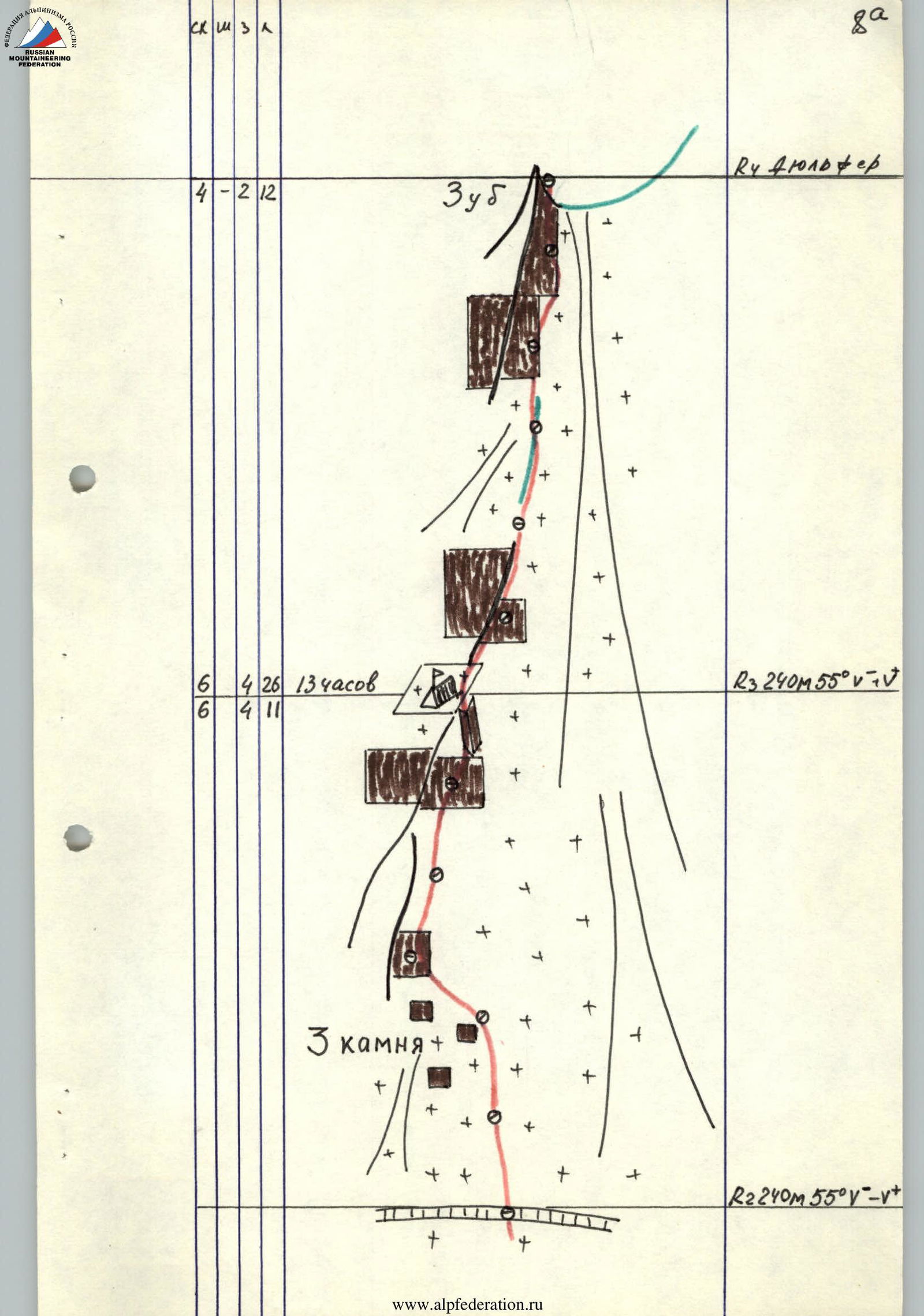
Section R4. Rappel from the "Tooth" southwards down a sheer wall with overhanging rock blocks.
Section R5. Traverse of the couloir and exit via a frozen inner corner to a ledge for a tent.
Section R6. Rock terrace. From here, it's convenient to prepare sections R7 and R9 if there's time and 4 ropes.
Section R7. Wall with flakes. Challenging climbing with a high probability of dislodging rocks with the rope. The wall ends on a rock terrace R8.
Section R9. Sheer wall with small holds. The wall looks inaccessible, but don't look aside — it's even more challenging there. Climbing is extreme, but it's possible without using artificial aids if you climb in galoshes and without a backpack.
Section R10. Wall of block structure. Need to exit onto the rib.
Section R11. Traverse right along the edge of snow and rock wall, then ascent up a steep inner corner.
Hazards:
- Be cautious of falling rocks from the upper part of the corner.
Sections R12–R13. Rib with sections of snow and rocks. The path is logical and doesn't need a description.
Section R14. Snow-covered ridge. Move to the left of the ridge. Descent from the summit via the ascent route. To the bivouac:
- 2 sport descents;
- 4 rappels.
From the bivouac, it's more advantageous to descend into the Aksu gorge. From the bivouac, pass about 40 m along easy rocks on an indistinct counterfort. We don't recommend entering the couloir descending from the saddle between the wall and the "Tooth" — there will be sheepbacks and potentially falling rocks and ice.
From the bivouac, 6 rappels are required to exit into a wide couloir between Iskander and Petrovgradets.
- Descent stations are typically located every 50–60 m;
- The rope may get stuck on flakes after being pulled through;
- Pay attention to the fourth rappel, which ends in a hanging inner corner (we recommend having a ladder).
Down the large couloir, descend along the southern wall of Petrovgradets to the glacier plateau.
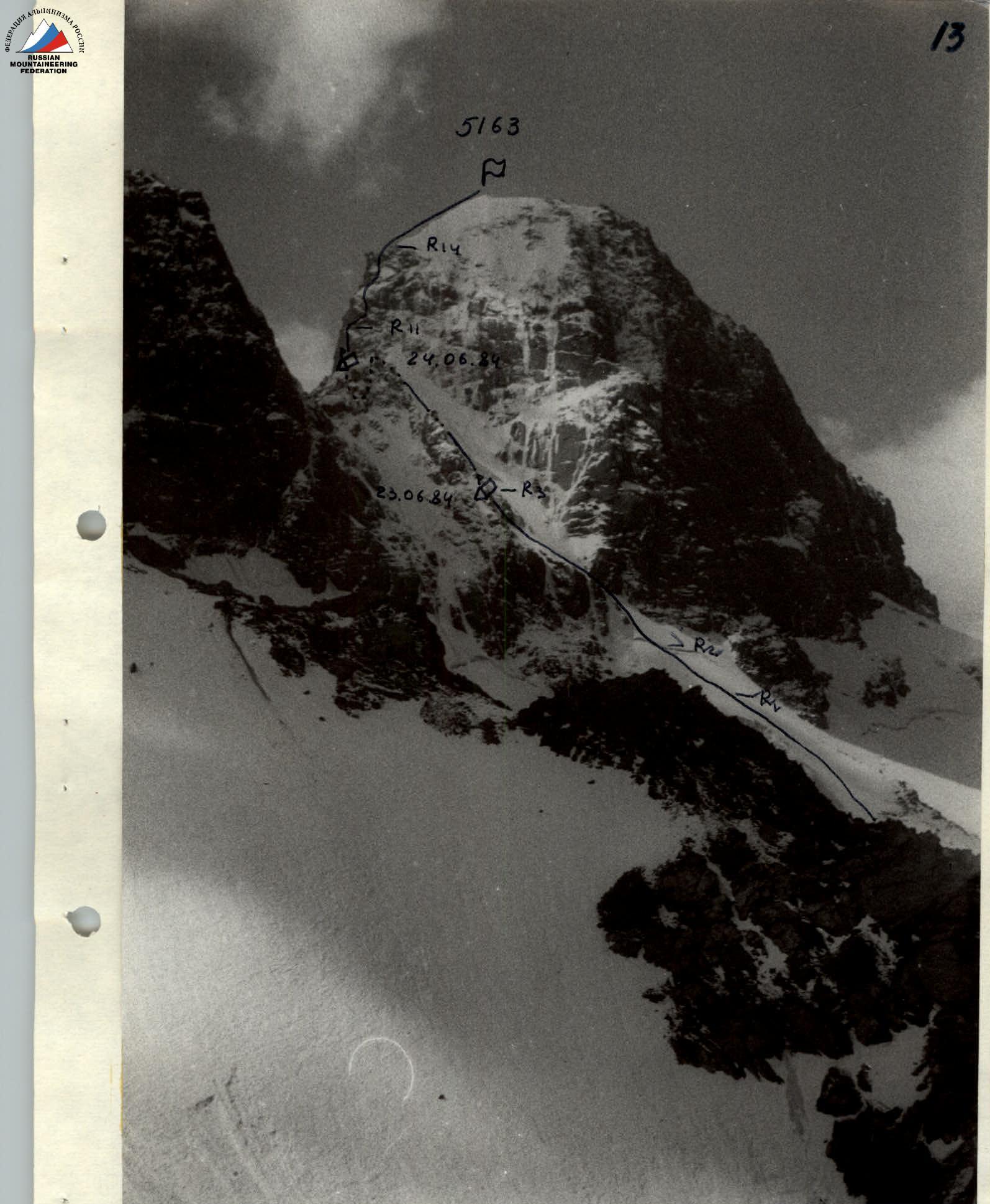
PHOTO 2. View of the route from the ridge under the Northwest wall of Iskander North peak. Shooting point: July 29, 1984, 11:30, H = 4300 m. Lens I-50 (50 mm).
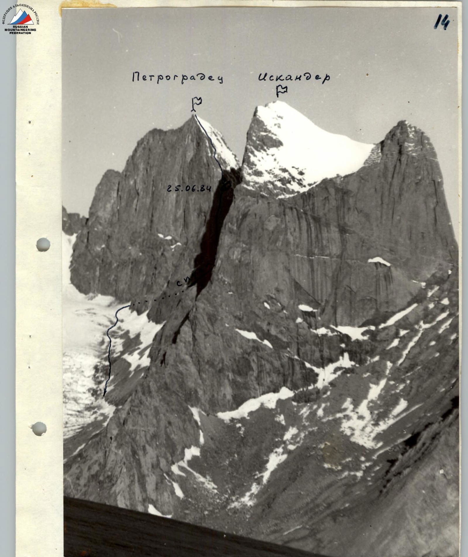
PHOTO 2. View of the route from the ridge under the Northwest wall of Iskander North peak. Shooting point: July 29, 1984, 11:30, H = 4300 m. Lens I-50 (50 mm).