Russian Championship in Alpinism. Altitude Class
Report on the Ascent of Peak Iskander via the South Face
Team from Moscow
2011
| 5. Height difference of the route: 1030 m, wall 625 m (by altimeter) |
| Route length: 1320 m |
| Length of sections: V cat. diff. — 345 m, VI cat. diff. — 245 m |
| Average steepness: |
| main part of the route — 85°, total route — 65°. |
| 6. Pitons left on the route: |
| total 0; including bolted 0 |
| Pitons used on the route: |
| stationary bolted 0, including ATO 10 |
| removable bolted 0, including ATO 0 |
| Total artificial points of support (ATO) used 84, including fifi hooks |
| Nuts and friends 126, including ATO 27 |
| Pitons 47, including ATO 15 |
| 7. Team's climbing hours: 48 hours, 6 days |
| 8. Team leader: Ivanov Alexander Sergeevich, MS |
| Participants: |
| Shulgin Maxim Alexandrovich, 1st sports category |
| 9. Coach: Ivanov Alexander Sergeevich, MS |
| 10. Start of the route: 15:00, August 6, 2011 |
| Reach the summit: 16:00, August 11, 2011 |
| Return to Base Camp: 23:00, August 12, 2011 |
| Descent via the S face |
| 11. Organization: FAiS Moscow |
| 12. Report responsible: Ivanov Alexander, ivanov@vdnk.ru, 8 (963) 992-11-35 |
ISKANDER, 5120 m Photo #1. General photo. Taken from Lake Aksu on August 6, 2011, distance 2.5 km, height 3900 m. GRISHCHENKO, 6A GOLUBEV, 5B ZHILTSOV, 6A
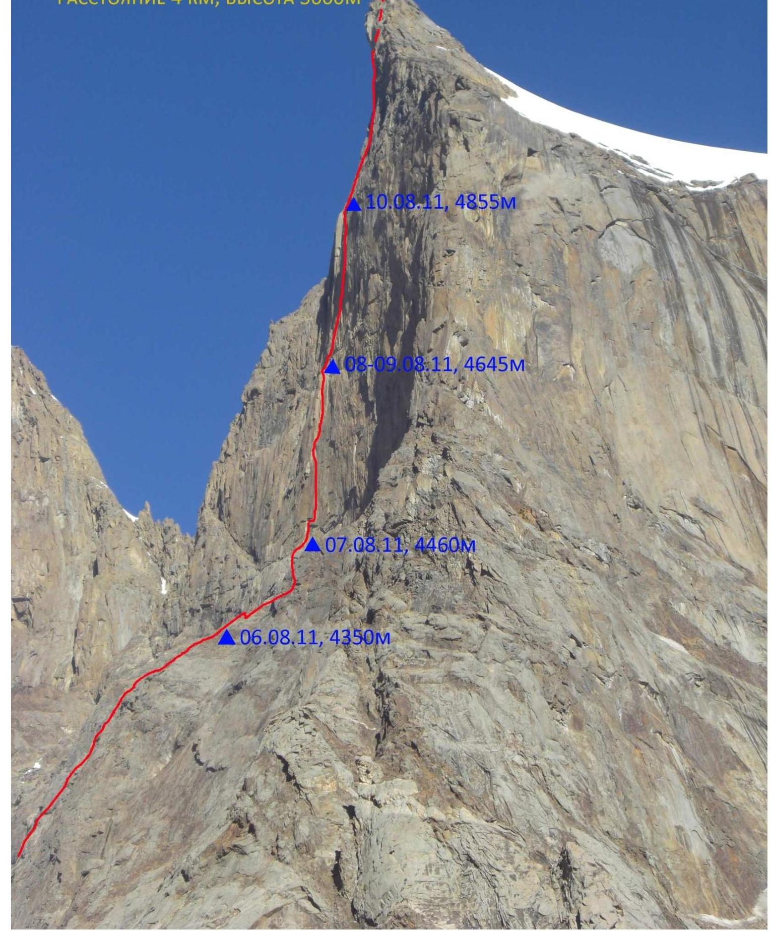
Photo #2. Route profile from the right. Taken on August 6, 2011 from Lake Aksu, distance 4 km, height 3600 m. August 11, 2011 — 5120 m.
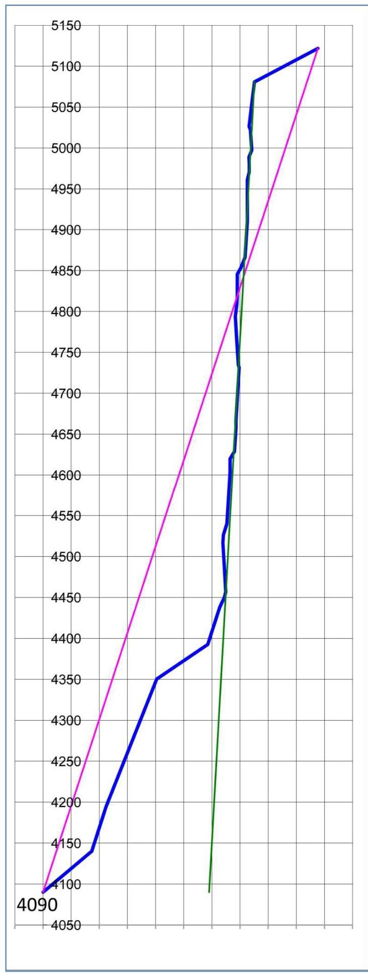
Drawn profile
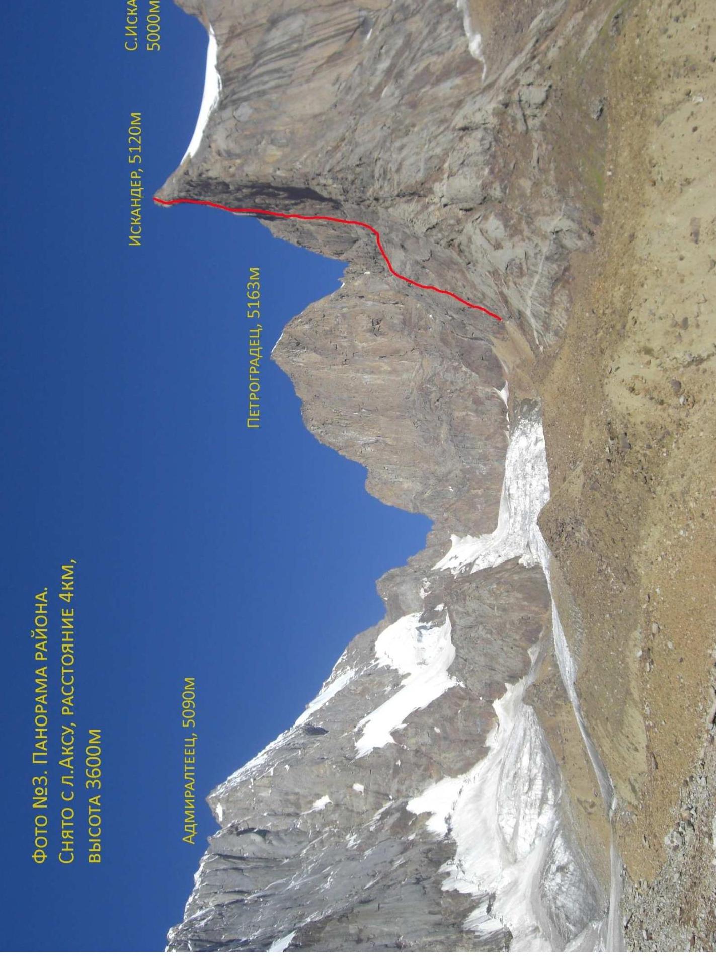
Photo #3. Panorama of the area. Taken from Lake Aksu, distance 4 km, height 3600 m. Admiralteets, 5090 m Petrogradets, 5163 m Iskander, 5120 m S. Iskander, 5000 m
| Pitons | Nuts | ATO | Section # | Length, steepness, difficulty |
|---|---|---|---|---|
| R0 | 100 m, 25°, I | |||
| 2 | 4 | R1 | 60 m, 65°, IV | |
| 2 | 3 | R2 | 60 m, 60°, III+ | |
| 1 | 6 | R3 | 60 m, 60°, IV | |
| 2 | 6 | R4 | 60 m, 30–90°, III–V | |
| R5 | 100 m, 25°, I | |||
| R6 | 100 m, 0–65°, I–III | |||
| 1 | 5 | R7 | 50 m, 65°, V | |
| 4 | R8 | 15 m, 55°, IV | ||
| 1 | R9 | 7 m, 70°, III | ||
| 4 | 2 | 9 | R10 | 15 m, 95°, VI+, A3 |
| 1 | 4 | 5 | R11 | 12 m, 95°, VI, A2; artificial |
| 2 | 7 | 25 | R12 | 45 m, 95°, VI, A2 |
| 1 | R13 | 10 m, 85°, VI | ||
| 1 | 4 | R14 | 15 m, 65°, IV | |
| 2 | 12 | R15 | 65 m, 85°, V | |
| 4 | 1 | R16 | 15 m, 90°, V+, A1 | |
| 1 | R17 | 10 m, 50°, III | ||
| 5 | R18 | 30 m, 85°, V | ||
| 1 | 1 | R19 | 8 m, 90°, V+ | |
| 2 | 6 | R20 | 45 m, 85°, V | |
| 4 | 4 | 12 | R21 | 20 m, 85°, VI+, A3 |
| 2 | R22 | 3 m, 120°, VI, A2, traverse 1.5 m | ||
| 2 | R23 | 15 m, 80°, V | ||
| 1 | 2 | R24 | 10 m, 85°, VI | |
| 2 | 2 | 7 | R25 | 12 m, 90°, VI+, A2 |
| 4 | 4 | 10 | R26 | 15 m, 90°, VI+, A3 |
| 1 | R27 | 10 m, 50°, III | ||
| R28 | 15 m, 60°, IV | |||
| 1 | R29 | 15 m, 60°, IV; 10 m, 50°, III | ||
| 1 | 5 | R30 | 45 m, 85°, V | |
| 1 | 3 | R30* | 15 m, 90°, V+ | |
| 2 | 4 | R31 | 35 m, 90°, V+ | |
| 1 | R32 | 10 m, 70°, V | ||
| 1 | 3 | R33 | 10 m, 90°, VI+ | |
| 2 | 2/1 | 1 | R34 | 8 m, 95°, VI, A1 |
| 1 | R35 | 10 m, 60°, IV | ||
| R36 | 25 m, 95°, VI, A2 | |||
| 5/4 | 4 | R37 | 5 m, 120°, VI+, A2 | |
| 3 | 6 | R38 | 55 m, 80°, VI | |
| R39 | 120 m, 20°, II | |||
| R40 |
Photo #4.5. Technical photo. Taken on August 12, 2011 during the descent from the lower part of the route. 39, 37, 33, 28, 26, 24, 22, 21, 20, 18, 16, 15, 14, 13, 12, 10, R9. 7. August 2011 8. 10. August 2011, 8–9. August 2011.
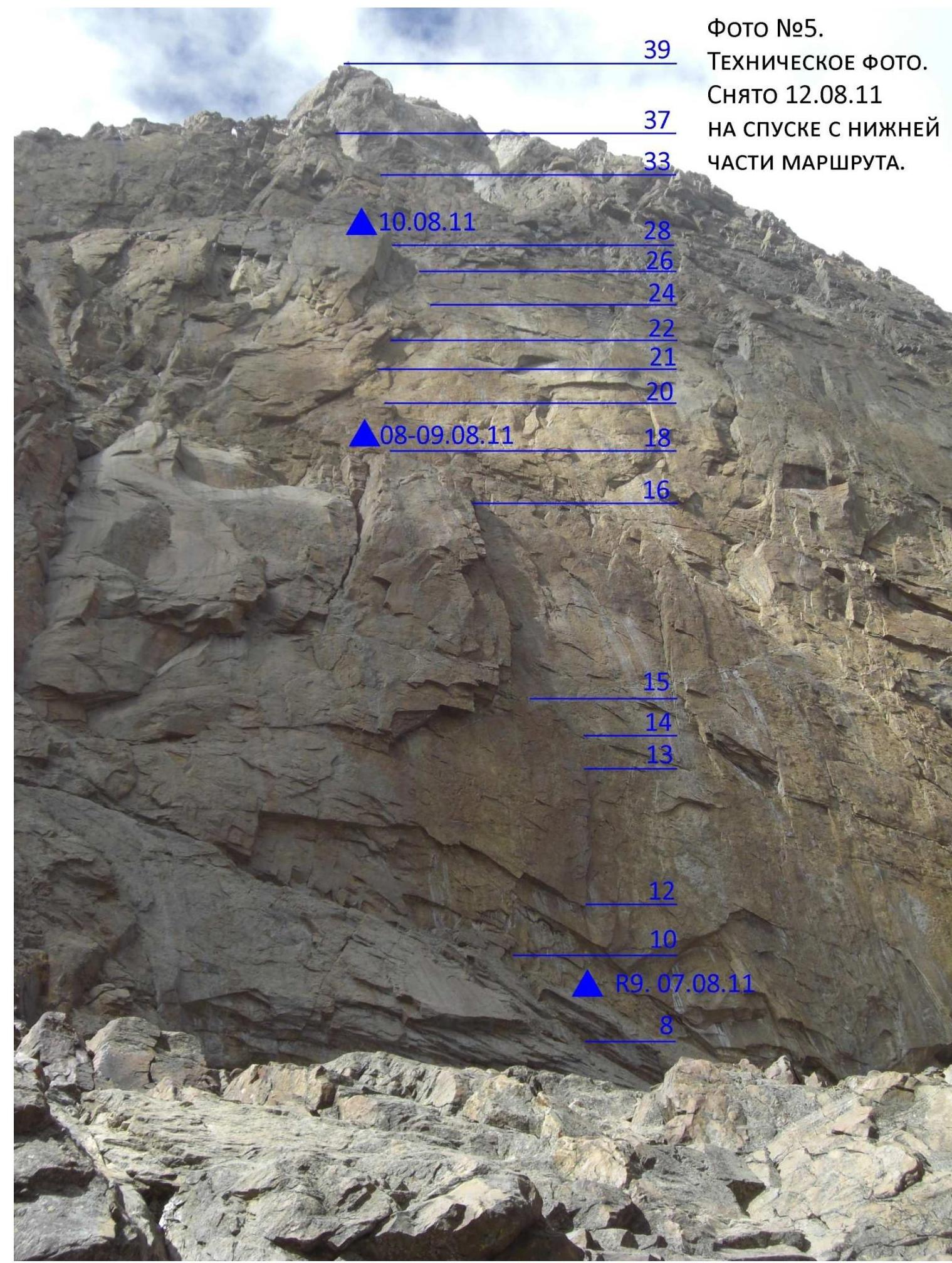
Photo #6. Technical photo of the upper part of the route. Taken from the bivouac R28 on August 10, 2011. R39, R38, R37, R36, R34, R33, R32, R31, R30, R29.
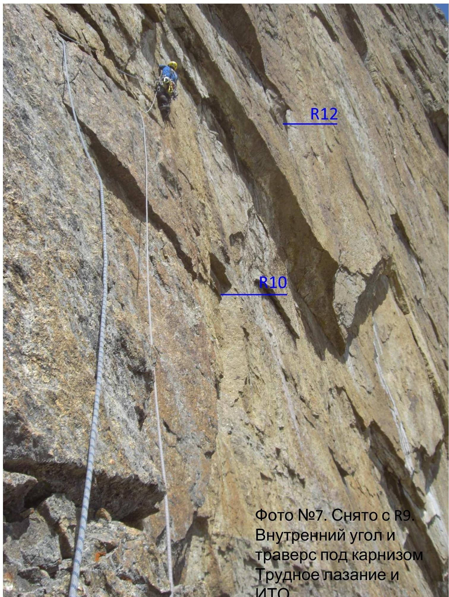
Photo #7. Taken from R9. Inner corner and traverse under the cornice. Difficult climbing and ATO. R10, R12.
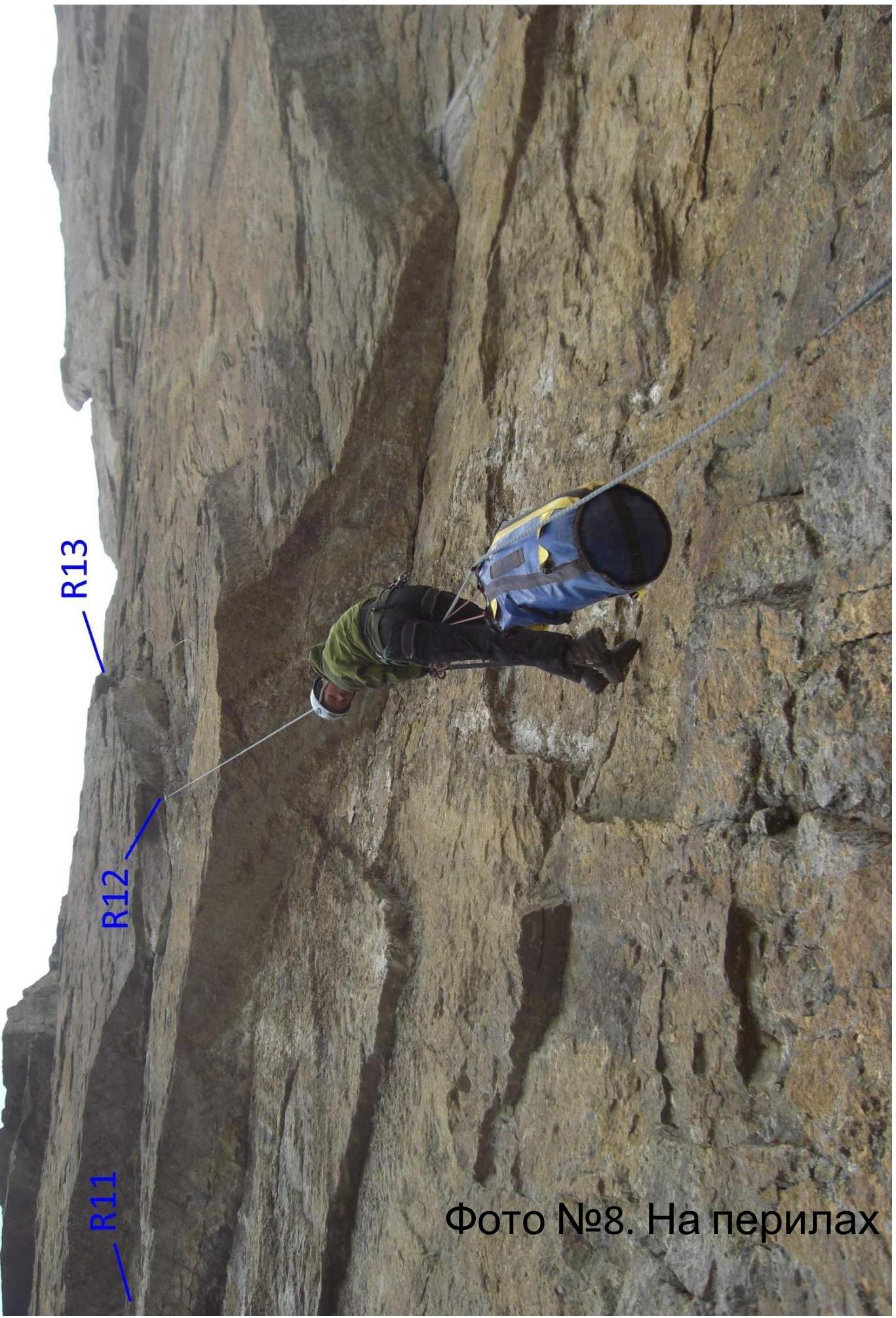
Photo #8. On the belay. R13, R11, R12.

Photo #9. On the belay. Taken from R20–R21. R21, R28, R24, R23, R22.
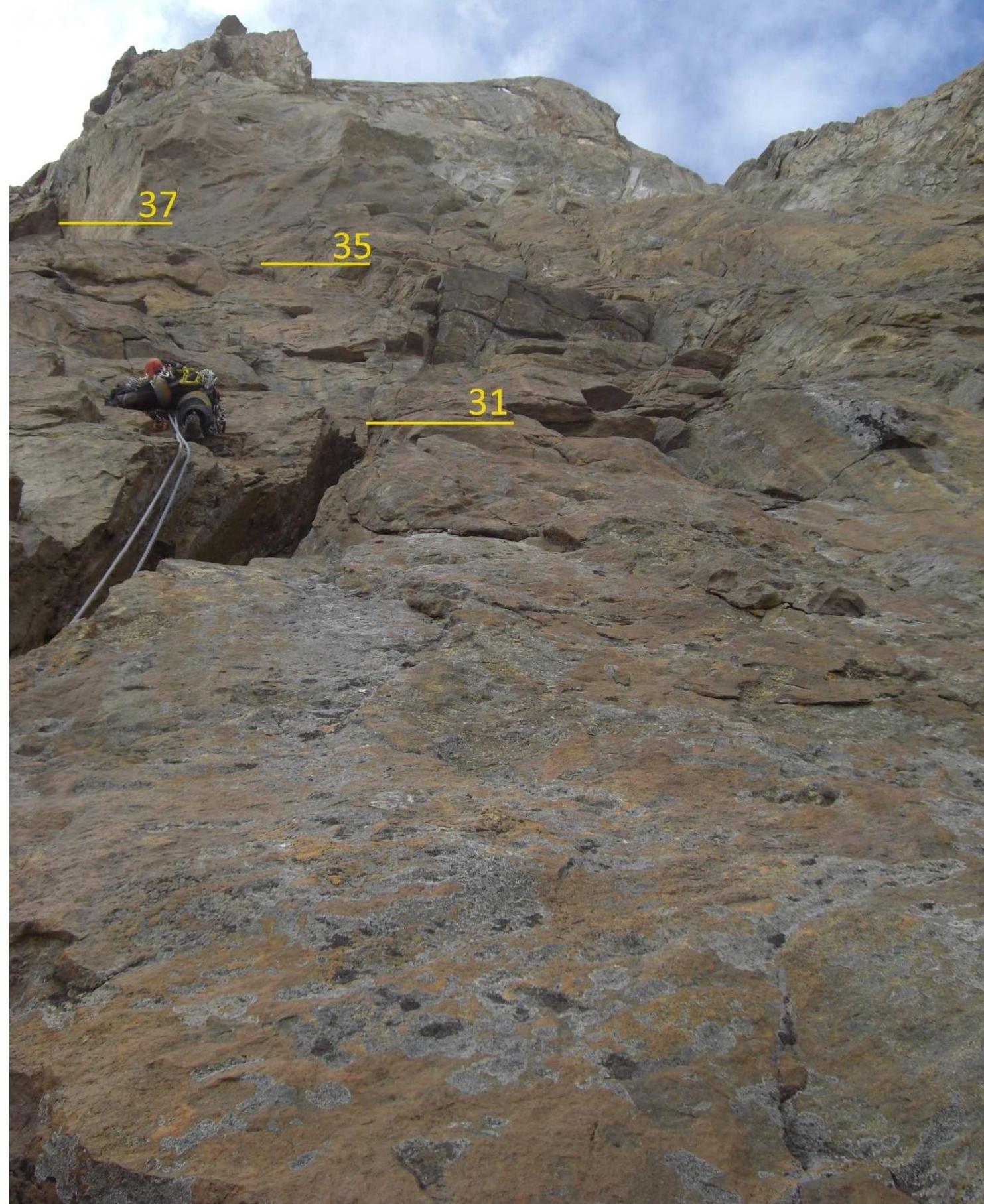
Photo #10. Taken from R30. Under the summit tower. 37, 35, 31.
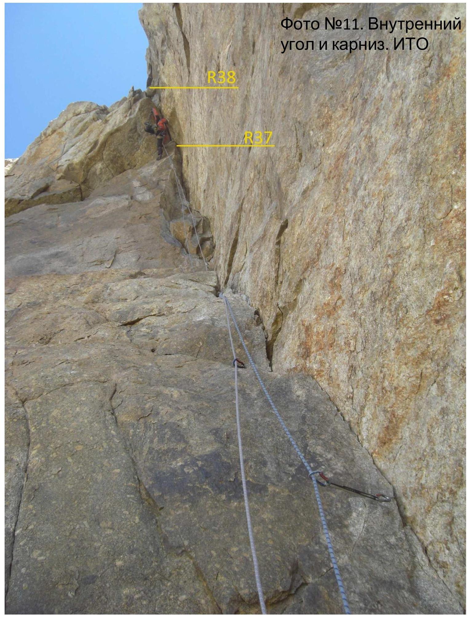
Photo #11. Inner corner and cornice. ATO. R38, R37.
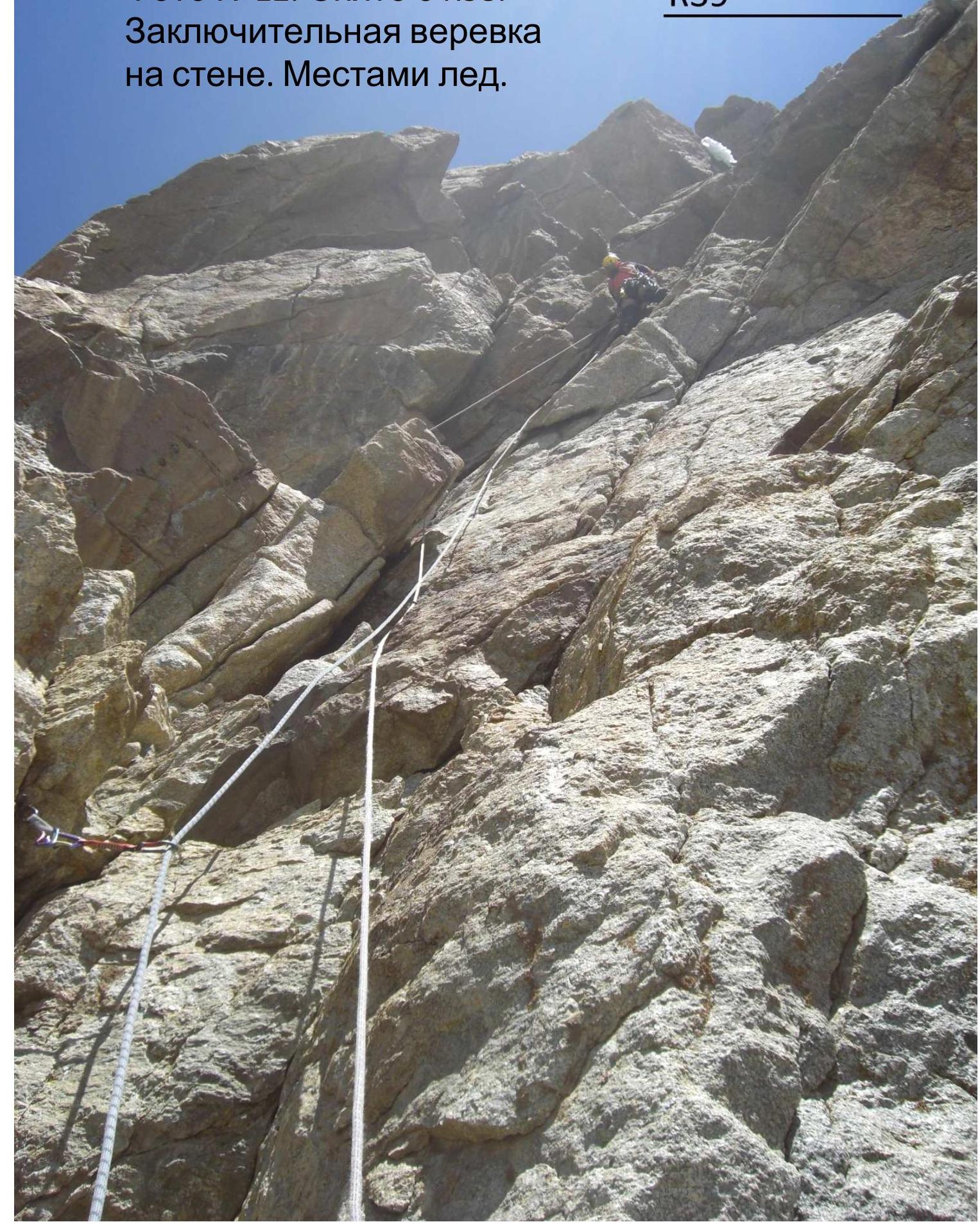
Photo #12. Taken from R38. Final rope on the wall. Ice in places. R39.
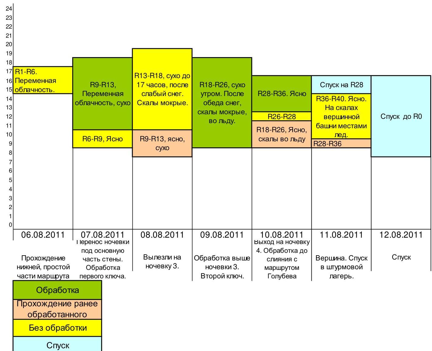
Photo #13. Summit. In the background — Admiralteets.
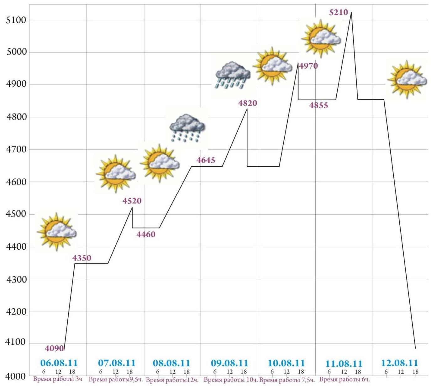
Photo #14. Summit.
Description by Sections
- R0–R1: Scree leading to the base of the couloir.
- R1–R2: To the left of the vaguely defined couloir is a system of inner corners. Climbing of medium difficulty.
- R2–R5: Movement to the left of the couloir along alternating ledges and walls. First climber wore shoes with a rucksack.
- R5–R6: Scree slope leading to the wall. Under the wall is a wide ledge, suitable for bivouac.
- R6–R7: Along the ledge, move right under the slab, above which is a cornice.
- R7–R9: Along the slab under the cornice, bypass it on the left via an inner corner, after which is a wide ledge. In the right part of the ledge is a safe bivouac under the protection of the cornice.
- R9–R11: Along a simple wall to the inner corner. Overhanging inner corner. ATO via cracks (fifi hooks, anchors). Cracks are filled with "scale", need to be cleaned.
- R11–R12: Difficult traverse climbing under the cornice to the base of a large overhanging inner corner. At the end of the traverse, ATO on nuts and friends along a crack at the base of the cornice.
- R12–R13: ATO up the inner corner. Better to set up a belay station at the top of the inner corner as the relief below is poor for protection. Mainly nuts and friends.
- R13–R14: Up the slab to the left, then up to the right. Careful climbing, managed to anchor only at the very beginning of the slab.
- R14–R15: Simple inner corner leads to the base of a large inner corner.
- R15–R17: Along the wall with rich relief for protection and climbing, to the right of the inner corner. In the middle of the corner is a control cairn. Further along a chimney with a plug. Nuts, friends.
- R17–R18: Along simple rocks, exit onto a large ledge. On the ledge is a platform suitable for bivouac for 3 people. Possibly, the ledge can accommodate 2–3 more people.
- R18–R21: Steep wall. Pleasant climbing. Good protection, a little of everything. At the end, at the base of the inner corner — a control cairn.
- R21–R23: Heavily contaminated crack along an overhanging inner corner. ATO on fifi hooks, anchors, nuts, small friends. The entire crack needs to be cleaned of "scale". Protection is not always reliable.
- Key to the route. At the top of the inner corner, cross it via a несложный cornice.
- R23–R24: Up the wall to the right to a suitable place for a belay station opposite the start of a large inner corner. Do not enter the inner corner or the vague couloir to the right, which is filled with ice.
- R24–R27: From the belay station, moved upwards. Difficult ATO. Many cracks are dead. Rocks are wet, местами во льду, climbing is possible only in places. Second key to the route. First ascenders probably bypassed this section to the right (probably correctly).
- R27–R28: Simple climbing to a large ledge, suitable for bivouac.
- R28–R33: Wall with rich large relief to the base of the summit tower. Live rocks present. Large nuts, medium and large friends.
- R33–R35: Vertical wall, then a weakly overhanging crack ending in a small cornice. One ATO move.
- R35–R36: Climbing up the inner corner to an inclined ledge, which is also reached by Golubev's route.
- R36–R38: Up the inner corner, bypassing the summit tower under the cornice. Initially climbing, then ATO with underclimbs. Cornice on ATO, belay station behind the cornice. Large, medium nuts, friends.
- R38–R39: Steep inner corner, ice in places. Pleasant climbing to a large ledge. Bivouac possible.
- R39–R40: Simple ridge leads to the summit.
Approach
- Peak Iskander is located in the Turkestan Range in the upper reaches of the Laylyak valley, in its left tributary — the Aksu valley. Approach from village Ozgurush up the Laylyak valley, then up the Aksu valley to the base camp at the site of the former Alay 5 camp — 5–6 hours.
- From the base camp, ascend the left bank of the Aksu river along the moraine to the cirque of Lake Aksu. Cross the stream flowing from the slopes of Peak Blok. Enter the cirque of the Aksu glacier. Approach the wall of Aksu. 3.5 hours from BC.
- Along the wall of Aksu and the "pillar" of Admiralteystvo, approach Peak Iskander. From the bivouacs under Aksu — 3–4 hours.
Schedule
| 06.08.2011 | 07.08.2011 | 08.08.2011 | 09.08.2011 | 10.08.2011 | 11.08.2011 | 12.08.2011 | |
|---|---|---|---|---|---|---|---|
| R1–R6 | Variable cloudiness | ||||||
| R9–R13 | Variable cloudiness, dry | ||||||
| R6–R9 | Clear | ||||||
| R13–R18 | Dry until 17:00, then weak snow. Rocks are wet. | ||||||
| R9–R13 | Clear, dry | ||||||
| R18–R26 | Dry in the morning. After lunch — snow, rocks are wet, icy. | ||||||
| R28–R36 | Clear | ||||||
| R26–R28 | |||||||
| R18–R26 | Clear, rocks are icy | ||||||
| Descent to R28 | |||||||
| R36–R40 | Clear. Ice on the rocks of the summit tower in places. | ||||||
| R28–R36 | |||||||
| Descent to R0 | |||||||
| Passage of the lower, simple part of the route | August 6, 2011 | ||||||
| Transfer of bivouac under the main part of the wall. Processing of the first key. | August 7, 2011 | ||||||
| Climbed to bivouac 3. | August 8, 2011 | ||||||
| Processing above bivouac 3. Second key. | August 9, 2011 | ||||||
| Exit to bivouac 4. Processing up to the junction with Golubev's route. | August 10, 2011 | ||||||
| Summit. Descent to the assault camp. | August 11, 2011 | ||||||
| Descent | August 12, 2011 |
Height Gain Schedule
08.06.2011, Working time 3 hours 07.08.2011, Working time 9.5 hours 08.08.2011, Working time 12 hours 09.08.2011, Working time 10 hours 10.08.2011, Working time 7.5 hours 11.08.2011, Working time 6 hours 12.08.2011
General Characteristics of the Route
- The route was first (and only once) climbed in 1998 by a team of 3 people in 7 days. The route starts to the left of a large, vaguely defined couloir.
- The route can be divided into 2 unequal parts: a simple beginning R0–R7 and a complex wall part R7–R39, which leads practically to the summit.
- In terms of complexity, the route can be compared to Pogorelov's route on Asan. Zhilin's route is a bit more complicated due to more destroyed rock in certain sections (R10–R11, R21–R22).
- Compared to other routes of 6 cat. diff., I believe this route is more complex than Forostyan's route on Chegem, Khokhlov's route on Sugan. However, it is less complex than Voronov's route on Peak Odessa (4810 m), Maksimen's route on Peak Blok, Voronin and Dorro's route on Erydag. In general, it can be said that the route is a complex 6A.
- I believe it is acceptable to climb this route as a first 6 cat. diff. route.
- The route was mainly climbed using free climbing. ATO was used on sections R10–R13, R21–R23, R24–R27 (due to ice and snow), R36–R38. The team passed sections R23–R27 in bad weather. Further to the summit, remnants of this bad weather remained on certain sections (wet rocks, ice).
- The most difficult sections of the route: R10–R12 — overhanging inner corner, ATO fifi hooks, anchors. After which is a difficult traverse climbing without reliable protection, then ATO. R21–R22 — crack is heavily contaminated, many points are not reliable, ATO on large nuts, small friends. R25–R27 — ATO via dead cracks.
- Tactics of the ascent — capsule style. The team used 3 ropes: 2 main dynamic ropes of 60 m, and a 1/2 dynamic rope — 8 mm. The first climber climbed on two ropes — main and 1/2, both used for belaying the first. The main rope was left for fixed ropes, and the 1/2 rope was used only for belaying the first. On all sections, Ivanov A. was the first to climb.
- Initially, the team did not bring skyhooks or a piton hammer.