-
Climbing category — technical.
-
Climbing region, range — Pamiro-Alay, Turkestan.
-
Peak, its height, ascent route — Peak 4974 (F. Dostoevsky), via the right counterfort of the SW wall.
-
Proposed difficulty category — 5A, combined.
-
Route characteristics: elevation gain — 620 m length of 5–6 sections — 130 m, average steepness — 45°
-
Pitons used: for belaying — 60 (rock) for creating artificial holds — 8
-
Total climbing time — 15.5 hours
-
Number of nights and their characteristics — one, bivouac.
-
Surname, first name, patronymic of the team leader, participants, and their qualifications:
Zander Sergey Egonovich — CMS (Candidate Master of Sports) Sorkin Alexander Davidovich — 1st sports category 192242 A.g., Gryzamеny тcмad 23–5–83
-
Team coach — Troshchinenko Leonid Andreevich
-
Date of departure and return: July 10, 1982 — July 11, 1982
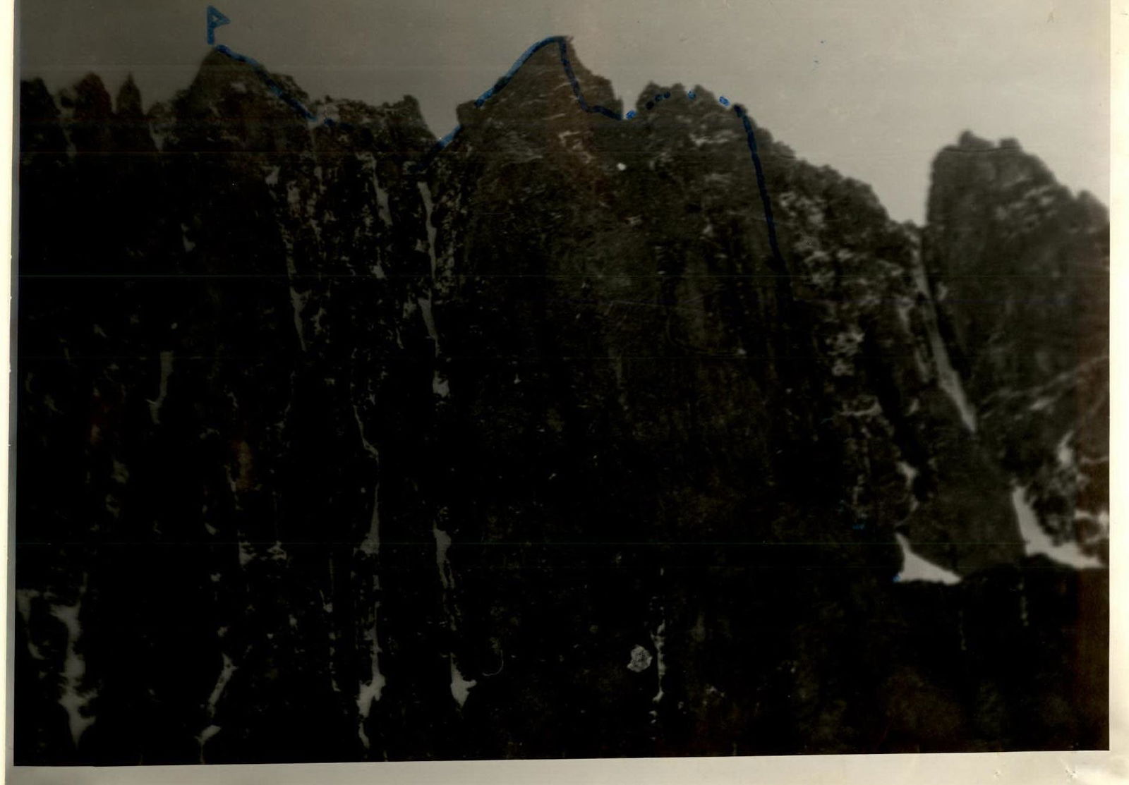 TABLE OF MAIN CHARACTERISTICS OF THE ASCENT ROUTE
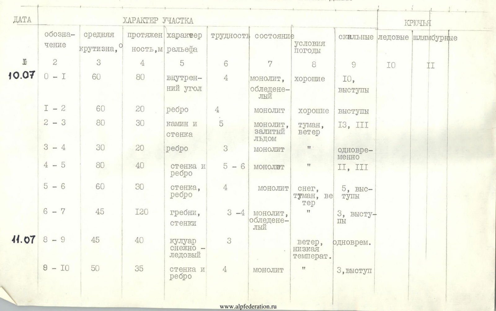
| DATE | Section | Average steepness, ° | Length, m | Terrain characteristics | Difficulty | Condition | Weather conditions | Rock pitons | Ice pitons | Bolt pitons |
|---|---|---|---|---|---|---|---|---|---|---|
| 10.07 | R0–R1 | 60 | 80 | inner corner | 4 | monolithic, icy | good | 10, outcrops | ||
| R1–R2 | 60 | 20 | ridge | 4 | monolithic | good | outcrops | |||
| R2–R3 | 80 | 30 | chimney and wall | 5 | monolithic, filled with ice | fog, wind | 13 | III | ||
| R3–R4 | 30 | 20 | ridge | 3 | monolithic | monolithic | simultan | |||
| R4–R5 | 80 | 40 | wall and ridge | 5–6 | monolithic | monolithic | II | III | ||
| R5–R6 | 60 | 30 | wall, ridge | 4 | monolithic | snow, fog, wind | 5, outcrops | |||
| R6–R7 | 45 | 120 | ridges, walls | 3–4 | monolithic, icy | monolithic, icy | 3, outcrops | |||
| 11.07 | R8–R9 | 45 | 40 | snow-ice couloir | 3 | wind, low temperature | simultan | |||
| R9–R10 | 50 | 35 | wall and ridge | 4 | monolithic | monolithic | 3, outcrop | |||
| R10–R11 | 60 | 60 | wall | 5 | monolithic, snowy, icy | strong cold wind, snow | 15, II, outcrops | |||
| R11–R12 | 0 | 150 | ridge | 2 | snow-rock | snow-rock | simultan | |||
| R12–R13 | 40 | 300 | snow-ice couloir | 3 | dense snow | dense snow | simultan | |||
| R13–R14 | 45 | 60 | wall | 3 | monolithic, snowy | monolithic, snowy | outcrops |
BRIEF EXPLANATION OF THE TABLE
Section R0–R1. Departure at 8:00. The Wide inner corner is icy in the upper part. Exit from the corner to the ridge under the chimney from right to left. Zander led first.
R1–R2. Ascend along the ridge from left to right to the base of the chimney filled with ice. Belay point is on the left of the chimney to avoid being hit by falling rocks and ice while climbing the chimney. Sorkin led first on R1–R2.
R2–R3. The chimney is climbed using a jam until the upper part. The main difficulty is getting out onto the short wall on the left side of the chimney. Artificial holds were used for 5 meters at the transition to the wall. The entire upper part was icy in the poor weather conditions. The chimney and the 3rd wall are bypassed on the right via a balcony visible from the start of the route.
R3–R4. After the chimney, we moved along the ridge to the next wall, climbing simultaneously.
R4–R5. The wall turns into a ridge. The upper part of the wall has an overhanging section that is climbed directly using artificial holds. The holds are smooth, with many vertical cracks suitable for placing protection gear. The ridge leads to a ledge under the base of the next wall.
R5–R6. The wall and ridge are climbed on the left side, leading to a ledge. After the ledge, the counterfort narrows and consists of alternating ridges and walls.
R6–R7. Climbing the ridges and walls is difficult due to the heavy icing. The ridge ends at a ledge that can be used to reach the bivouac. The ledge turns into a ridge leading to the base of the "Bird" gendarme. However, due to bad weather, the team stopped to organize a bivouac immediately after reaching the ledge. There are many places for bivouacking to the right of the counterfort. The team bivouacked at the base of the couloir leading to the "Bird" (section R8–R9). Stop at 16:30.
R8–R9. The snow-ice couloir is climbed along the right slope of the ridge and leads to it. Climbing started at 8:00.
R9–R10. Move along the ridge and wall to the base of the "Bird". The belay point is inconvenient, but there is no better option.
R10–R11. The "Bird" gendarme is visible from the Ak-su river valley and throughout the approach to the route. It is climbed directly. The difficulties encountered were heavy snow cover, icing, and smooth micro-relief, as well as very strong wind with snow and fog. After 40 m, a monolithic "finger" protrudes from the wall, providing a convenient belay point. The remaining 20 m are less difficult and lead to a large ledge. Time of arrival at the ledge — 12:30.
R11–R12. The ledge turns into a simple, horizontal ridge. The gendarmes are bypassed on the right. The ridge ends at a narrow section that leads to the base of a snowy couloir, climbing from left to right.
R12–R13. In the snow-ice couloir, move first upwards to the narrowing, then slightly to the right towards the branching of the couloir. From the branching point, move to the left couloir under the summit tower. The steepest section is at the branching point, where ice formations require crampons.
R13–R14. The couloir leads to the eastern ridge of the summit. From the top of the couloir to the summit, there are simple rock sections, 60 m. The team reached the summit at 15:00.
Descent was made via the ascent route. Total descent time to the base of the route — 5 hours.
In the team's opinion, the route: — is logical, — is well visible, — corresponds to 5A category.
Technically more challenging than routes of similar difficulty category on Peak Ay-Lama and Peak 4800 "Karaganda" "Guamysh".