Classification Commission of the USSR Alpine Federation The quality of photographic materials does not correct No. 32. Classify the route. Classified 3 cat. sl. No. 533 from No. 529 November 22, 1983.
Report
on the first ascent of p. 4974 (peak F. Dostoevsky) via the right counterfort of the Southwest wall by the group of LOS DSO "Burevestnik" gathering. Group leader Evstigneev A.V. July 5–7, 1982.
Leningrad
Tactical actions of the team
The group started the ascent in the following rope team configuration: Litskevich–Pruss, Vasiliev–Shaginyan.
Departure from the bivouac under the route on July 14, 1983, at 8:30 after a communication session. The steep part of the couloir was traversed by 14:00. Exit to the ridge at 15:00.
Stop for a bivouac on the ridge before descending to the saddle before the "Tower" gendarme — 17:30.
July 15, 1983, departure from the bivouac at 9:00, passing the "Tower" gendarme at 13:30, reaching the summit at 18:00, returning to the bivouac under the route via R10, descending from the summit at 21:00.
Return to the base camp — July 16, 1983, at 12:00. The southern slopes of p. Dostoevsky are late in being lit by the sun, as they are shaded by the ridge adjacent to the peak from the east; radio communication from the couloir that the group ascended is unlikely. This explains the relatively late departure from the bivouac.
The abundance of exposed ice (section R1–R2), not anticipated by the group which brought only one pair of crampons, led to:
- step cutting;
- use of ropes;
- a 1-hour delay compared to the plan.
The overnight stay on July 14, 1983 (point 6) was organized earlier than planned, as a review of the further path showed that the group would not reach a site with good conditions for radio communication that day.
Based on advice received via radio communication from teams that ascended on July 13 and 15 via the right counterfort of the Southwest wall, the descent route was altered — instead of returning via the upper ridge and couloir, the descent was made via a couloir descending from the summit to the south, where these groups had left rappel loops and pitons (section R14–R15).
Ropes were used on the following sections:
- R1–R2;
- R4–R5;
- R6–R7;
- R7–R8;
- R9–R10;
- R10–R12;
- in the lower part of the descent couloir (R14–R15).
The bivouac site (point 6) was trampled in the snow. This site was also used by two other groups from the MS DSO "Zenit" gathering, although they moved at a higher pace.
On the ridge (section R5–R6) and on the saddles R7 and R11, there are:
- snow cornices hanging to the north;
- thawing snow on rock ledges.
 Map of the Ak-su region. Turkestan ridge. Scale 1:100 000
 Route croquis in UIAA notation
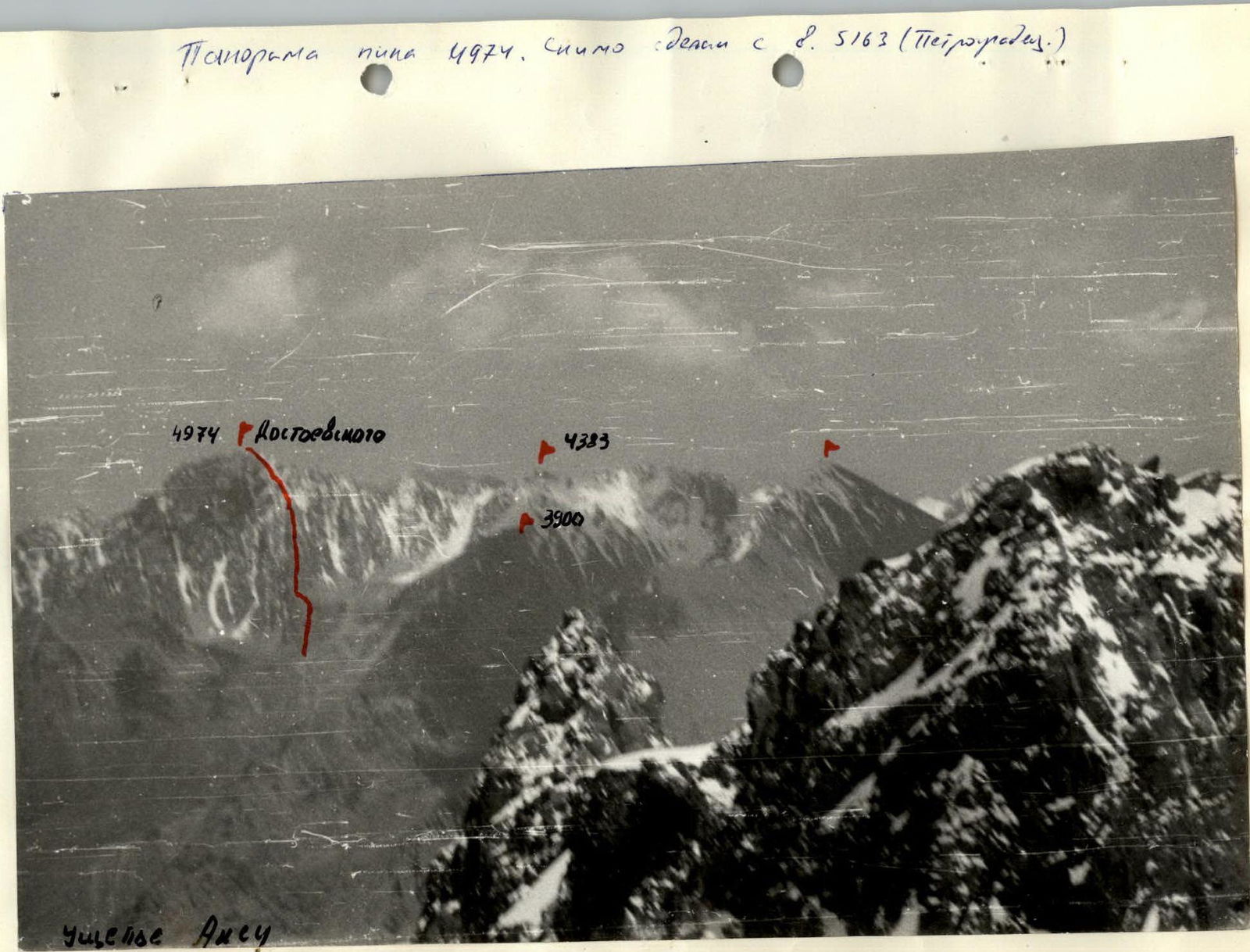 Panorama of peak 4974. Photo taken from v. 5163 (Petrogradets).
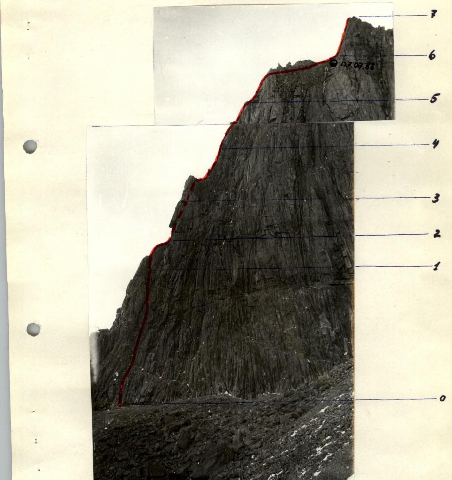 Profile of the wall section of the route.
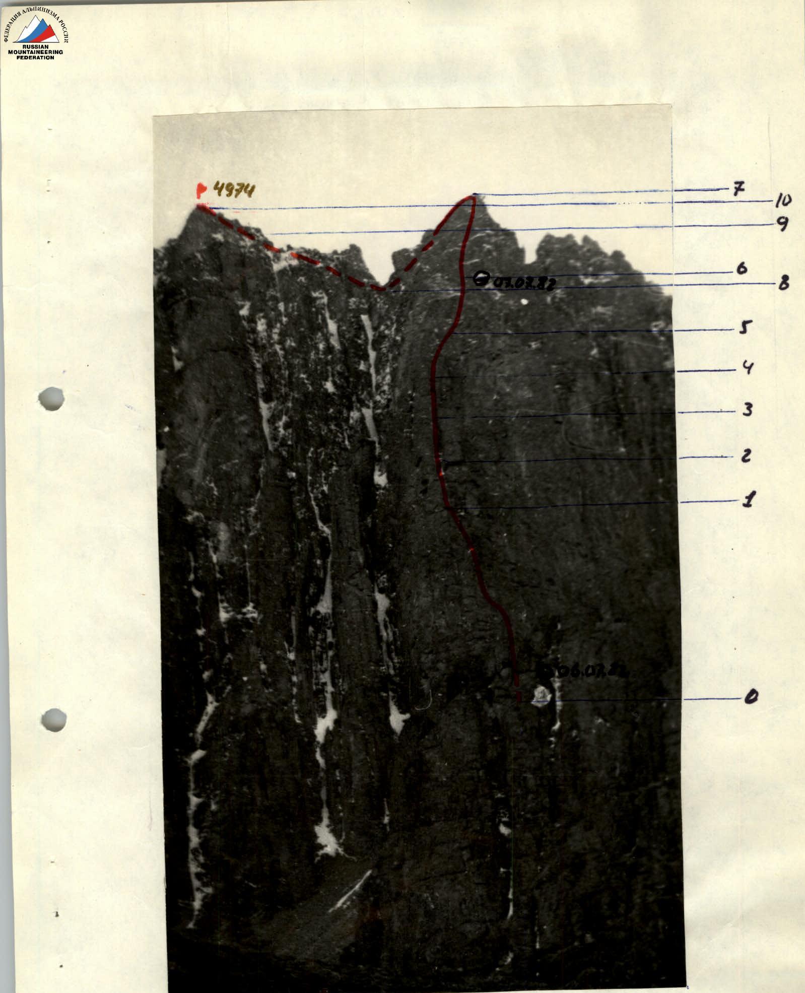 General view of the route.
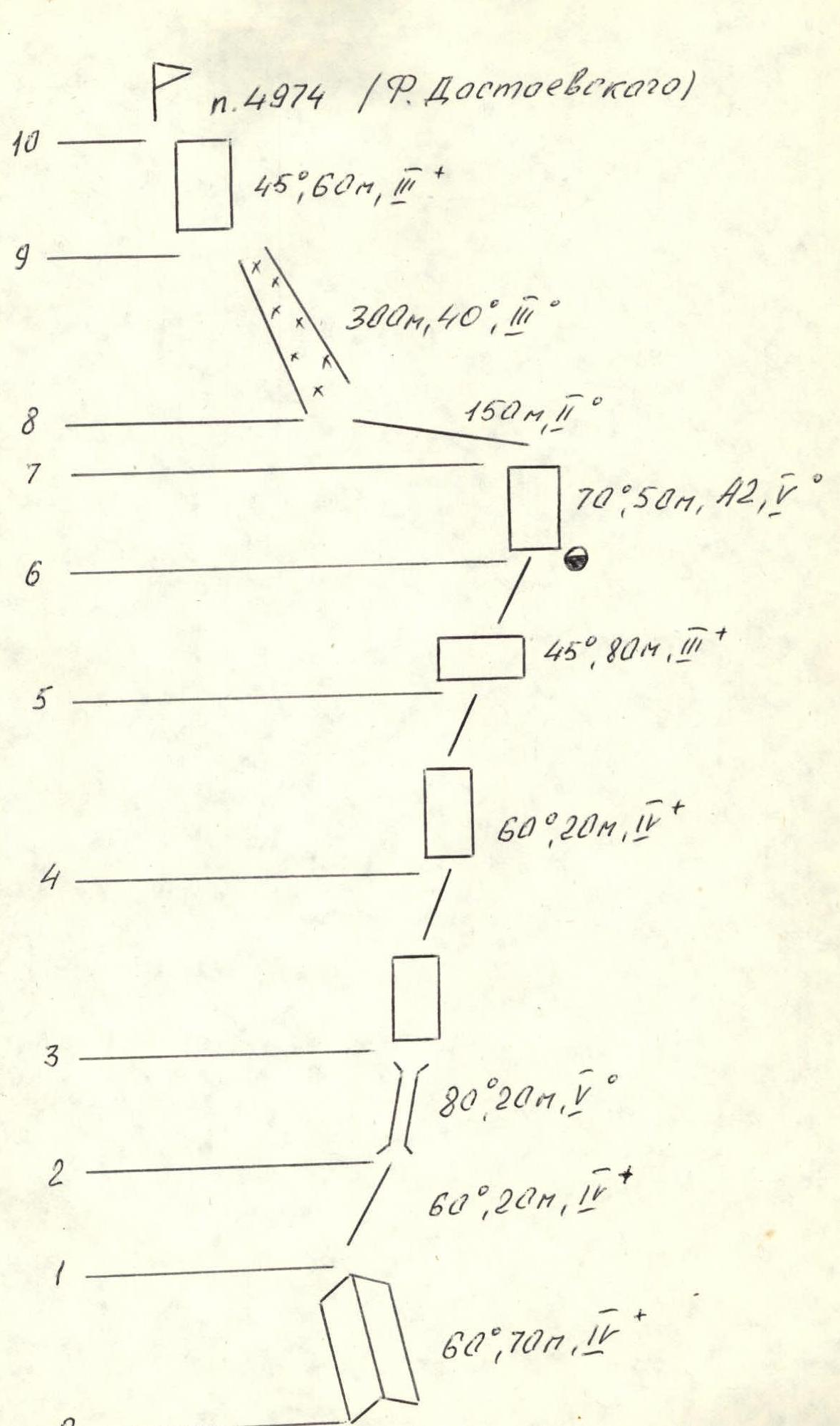
Route description
Section R0–R1 A steep, not clearly defined internal corner with good holds leads to the edge of the counterfort.
Section R1–R2 Straight up along the edge — exit to a ledge, left of a large cornice.
Section R2–R3 Movement to the left of the cornice through a snow-filled chimney. From the chimney — a difficult exit left — upwards. Here is a convenient site.
Section R3–R4 A steep wall on the edge. Under the wall, a control cairn is set up.
Section R4–R5 Movement along the edge straight up. From here, a wide view opens up to the upper tower of the counterfort.
Section R5–R6 The counterfort becomes significantly gentler. Through a system of ledges and walls, moving right — exit under the upper tower of the counterfort. Here is a convenient site for an overnight stay.
Section R6–R7 The upper tower is overcome directly head-on. The rocks are monolithic and smoothed. Freshly fallen snow significantly complicates the movement.
Section R7–R8 The upper edge of the counterfort. Movement with almost no gain in height. Gendarmes are bypassed on the right.
Section R8–R9 A wide snow couloir leads to the main ridge under the base of the summit tower.
Section R9–R10 Exit to the summit via heavily broken rocks and a small monolithic wall, straight from the saddle.
Table of main route characteristics
| Date | Designation | Average steepness, degrees | Length, m | Terrain characteristics | Difficulty | Condition | Weather conditions | Rock pitons | Nuts |
|---|---|---|---|---|---|---|---|---|---|
| July 6 | R0–R1 | 60 | 70 | internal corner | 4 | monolithic | good | 8 | 5 |
| R1–R2 | 60 | 20 | edge | 4 | monolithic | good | 2 | 2 | |
| R2–R3 | 80 | 20 | chimney | 5 | snow-filled | good | 4/1 | 2 | |
| R3–R4 | 90 | 20 | wall | 5 | monolithic | good | 2/2 | 1 | |
| R4–R5 | 60 | 20 | wall | 5 | monolithic | good | 3 | 1 | |
| R5–R6 | 45 | 80 | small walls, ledges, ridge | 3 | broken | good | 3, outcrops | 3 | |
| Departure time — 8:00, stop for bivouac — 19:00, total travel hours for the day — 10. Overnight stay lying on a ledge under an overhang, wind, snowfall at night. | |||||||||
| July 7 | R6–R7 | 70 | 60 | wall | 5 | snow-covered | good | 8, 2 | 5 |
| R7–R8 | - | 150 | ridge | 3 | broken | storm, snowfall | 5 | 4 | |
| R8–R9 | 40 | 300 | couloir | 3 | deep snow | snowfall, fog | - | - | |
| R9–R10 | 45 | 40 | ridge | 3 | broken | fog | outcrops | - | |
| Departure time — 8:00, reaching the summit — 14:00, travel hours — 6. Descent from the summit via the ascent route, descended by 20:00. |