I. Technical class
2. Pamir-Alay, Ak-su valley
3. Peak Dostoyevsky (4974 m) via the East ridge, combined
4. Proposed category 4B, first ascent
5. Height difference 570 m, length 1320 m. Length of sections category 4 — 280 m, category 5 — 40 m. Average slope of the route 27°, average slope of the couloir 30°, average slope of the ridge 20°, slope of the summit tower wall 60°
6. Pitons driven: rock 40, chockstones 30
7. Climbing hours — 19, days — 2
8. Overnight stay: 1st on a site prepared on a snowy ridge
9. Leader: Viktor Pruss, 1st sports category. Participants: Serafim Vasiliev, 1st sports category. Valentin Litskevich, 1st sports category. Izolda Shaginyan, Master of Sports of the USSR
10. Coach: Yuri Kozlov, Master of Sports of the USSR
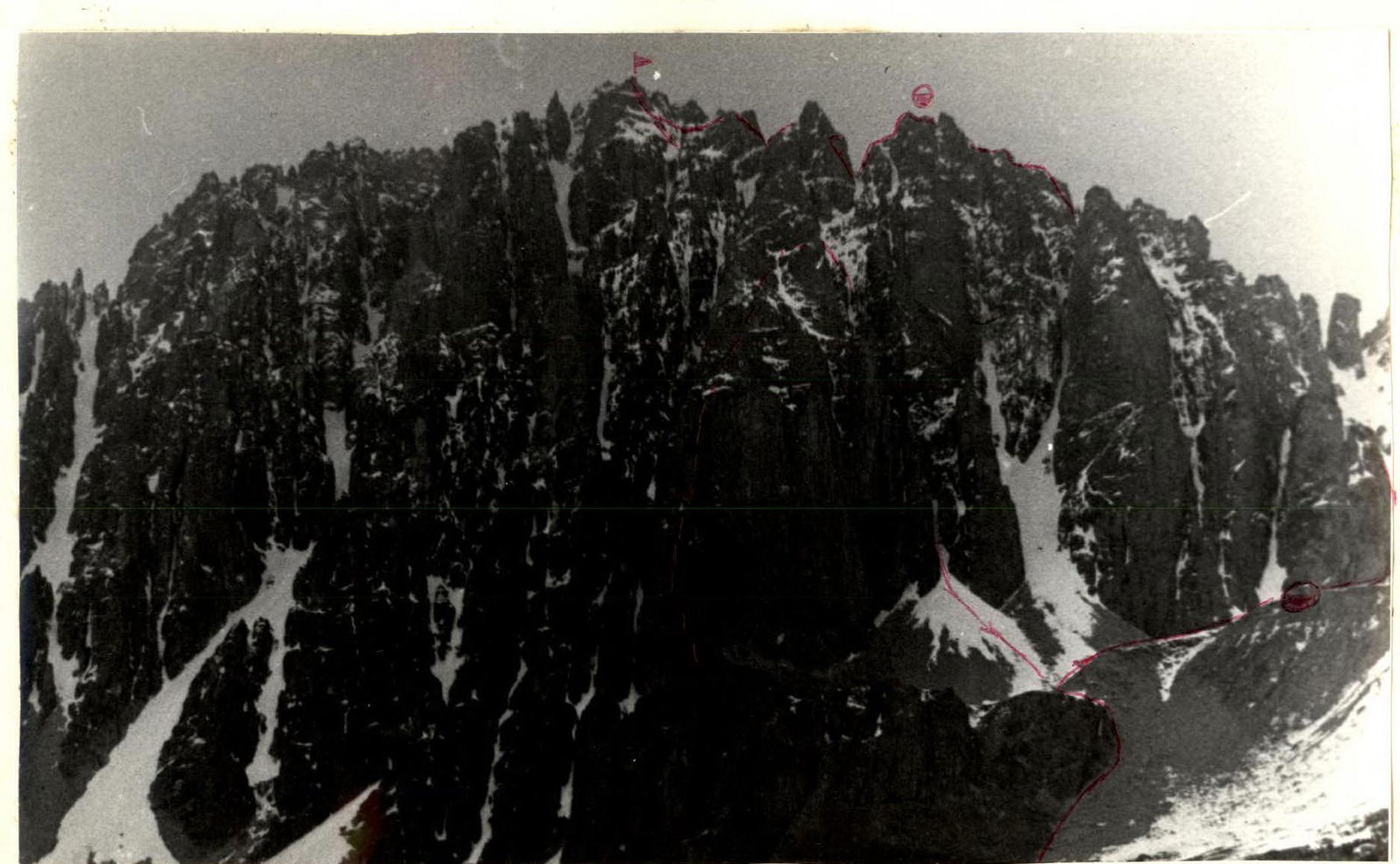
Photo 1. Peak Dostoyevsky. View from the south. Taken from point 2 on July 13, 1983 at 14:00. Distance 2 km, height 4000 m, lens "Industar-55"
- The group's route — route through corridor 113 walls
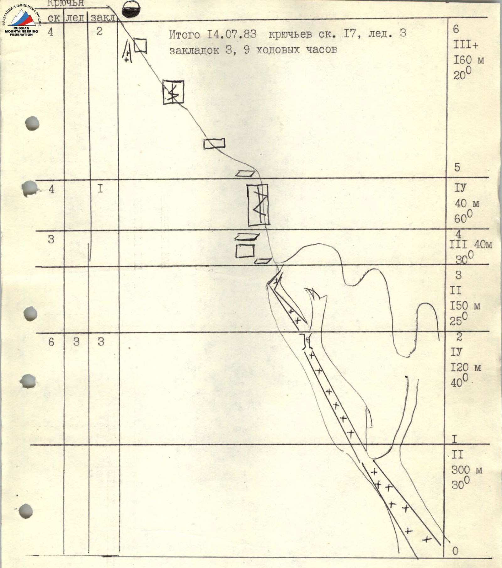
Route diagram from the initial bivouac to the overnight stay at 4800 m. Sections R1–R3, see photo on sheets 14, 15.
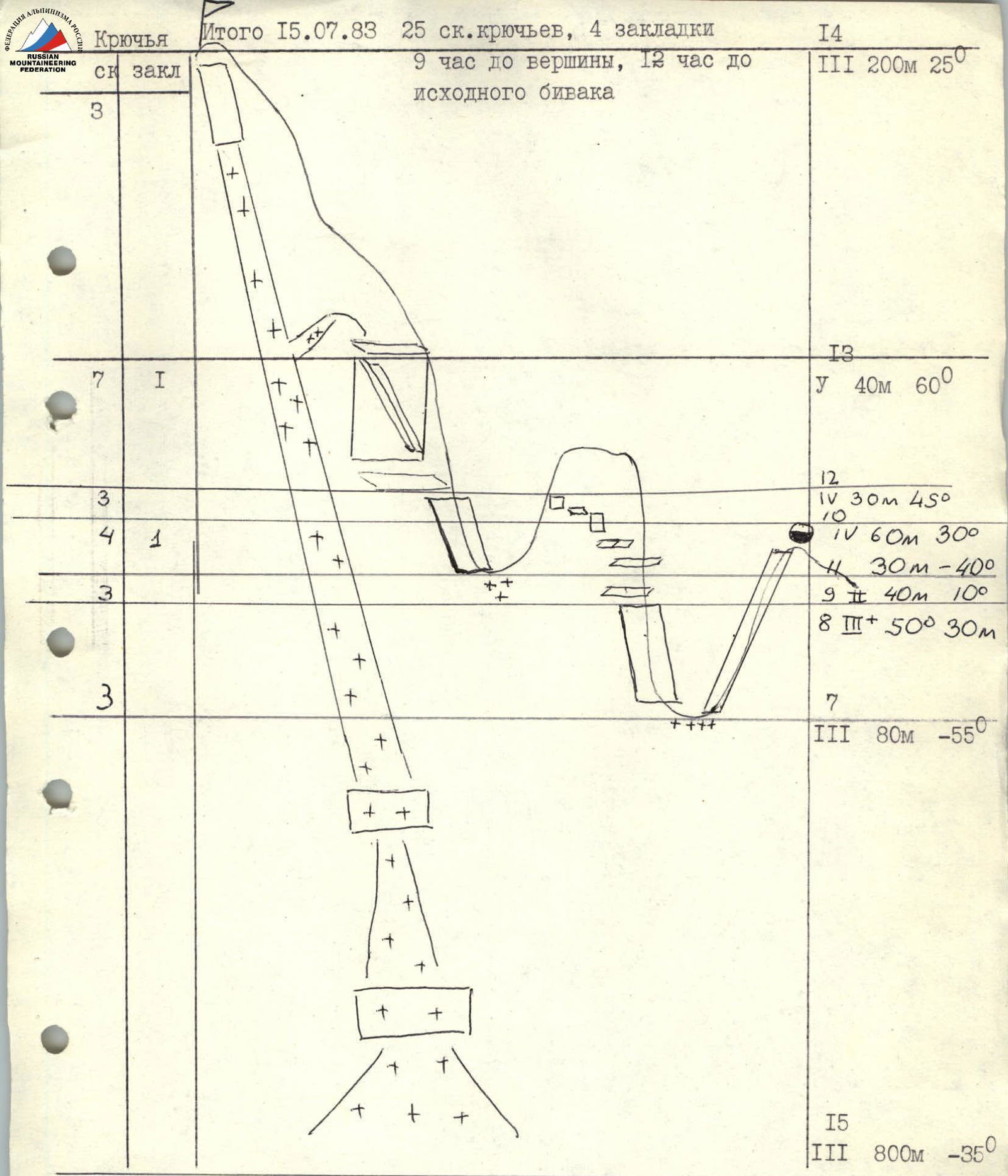
Route diagram from the overnight stay at 4800 m to the summit of Peak Dostoyevsky. Section I3–I4, see photo of the summit on sheet 16.
- 0–I — From the bivouac on the moraine terrace to a wide couloir flowing from the E ridge (snow and scree). The couloir is avalanche-prone, passage before 02:00. (300 m, slope 30°, category 2)
- I–2 — Ascent into the left tributary of the couloir; steep ice, partially covered with snow, individual rock outcrops; average slope 40°, last 15 m — 60° (120 m, category 4)
- 2–3 — The couloir becomes less steep (25°) and leads to a snowy saddle between the buttress and the E ridge; before reaching the saddle, turn into the right source of the couloir under the gendarme of the E ridge. (150 m, category 2)
- 3–4 — Exit onto the gendarme, bypassing its wall on the left. Exit onto a ledge on the left, ascent onto an 8-meter rock wall onto a snowy ledge of the gendarme (40 m, category 3)
- 4–5 — Ascent onto the gendarme via a rock wall with a cleft in the right part of the ledge; piton belay and through ledges (60°, 40 m, category 4)
- 5–6 — Ridge is rocky, snowy, with cornices on the northern side; rock walls up to 3–5 m; at the end of the section there is a good overnight stay site on snow (20°, 160 m, category 3+)
- 6–7 — Rappelling 2 × 40 m (upper loop on a ledge, second — on pitons) onto a snowy saddle (cornices) under the gendarme "Tower"
- 7–8 — Ascent via the rocks of the gendarme to a ledge on it (50°, 30 m, category 3+)
8–9 Bypassing the gendarme along the ledge to the right, crossing the beginning of the couloir — chimney, 40 m; rocks, partially snow (40°, 40 m), category 2. 9–10 Continuing the bypass on the northern side of the gendarme. The ledge is snowy. The rock wall partially overhangs — is rejected, descent into the couloir 3 m, ascent via the wall to the other side 8 m and further via a 10-meter wall (rocks are destroyed and snowy) onto a site (30°, 60 m), category 4. 10–11 Descent onto a snowy saddle (cornices) between the gendarme "Tower" and the summit massif; snowy rocks — 30 m, sports style.
11–12 Ascent onto the summit massif, destroyed rocks, to a snowy ledge under the wall (45°, 30 m, category 4). 12–13 Via the wall from right to left, ascent via an inner corner onto a saddle (60°, 40 m, category 5). 13–14 Via snowy rocks of the ridge, exit onto the summit. From the overnight stay under the couloir to the summit — 16 climbing hours. 14–15 Descent via a snowy-icy couloir to the south, 3 hours, 5 rappels (25°, 200 m, category 3).
Sections category 4 — 280 m, category 5 — 40 m.