 It is difficult, practically impossible, to capture the route profile. The ridge along which the route runs is zigzag-shaped and is blocked from the south by the towers of gendarmes.
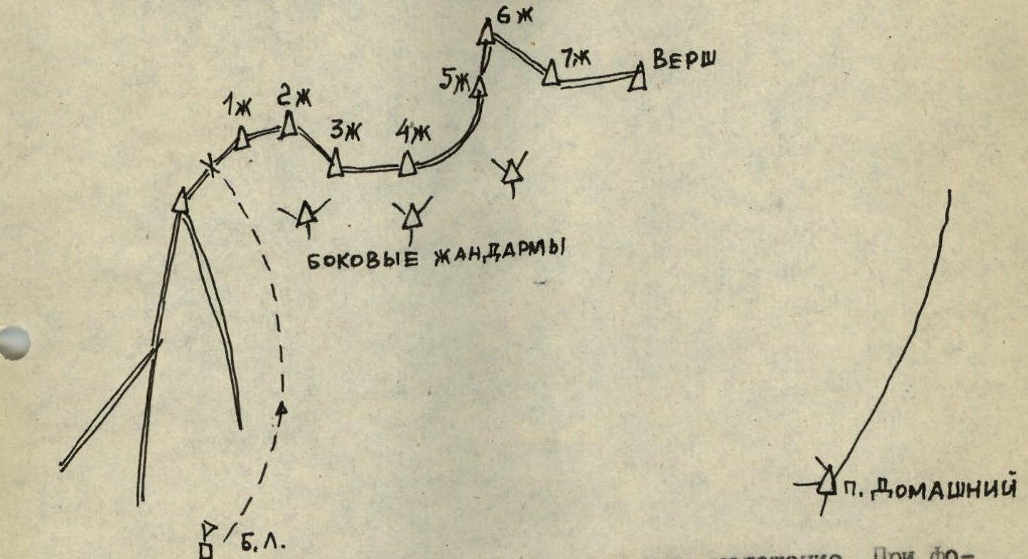
Photos taken from below, from the moraine, result in overlapping images. Photographing from Peak Domashny also results in overlapping ridge bends, plus details are not visible due to the large distance. A frontal photo captures only 1–2 nearest ascents; the rest of the ridge is blocked by gendarmes.
Approach Description
From the base camp, bypassing the southern spurs of the peak Dostoevsky to the right, ascend via scree under the southern slopes of peak Dostoevsky (5 hours from the camp). Approach the western ridge via moraine to the first long snow couloir on the left.
R0–R1. Ascend the 35° 1000 m snow couloir to a saddle on the western ridge before the 1st gendarme (3 hours from the moraine). The couloir is avalanche-prone; it is recommended to pass it in the morning. Behind the saddle on the ridge is a good place to spend the night in a hollow.
R1–R2. Bypass the 1st gendarme to the right. Descend 50 m to a snowy inclined ledge. Rocks with ice formations. Traverse right and upwards to a steep snow couloir.
R2–R3. Ascend the couloir to a narrow saddle before the 2nd gendarme. In the narrow part of the couloir is a 15 m ice chute.
R3–R4. Ascend the 2nd gendarme directly, snowy rocks.
R4–R5. Descend via snowy rocks with top rope on a snowy cornice.
R5–R6. Snowy cornice turning into a snowy wall, loose snow on a smooth rock slab.
R6–R7. Smooth slab, exit to the 3rd gendarme.
R7–R8. Between the 3rd and 4th gendarmes, traverse a snowy ridge with a cornice on the north, 3–4 meters to the right of the ridge line. Insure with an ice axe, treading down the platform, as the snow is very loose.
R8–R9. Descend into three 10 m deep depressions.
R9–R10. Traverse a rocky tooth to the right.
R10–R11. Bypass the 5th gendarme to the right and exit onto its snowy summit from the south. A hollow provides a convenient place to spend the night. Descend from the 5th gendarme to the north onto a saddle with the 6th gendarme.
R11–R12. Traverse the 6th gendarme to the right below, on rocks, to exit onto an inclined slab.
R12–R13. Rappelling from the inclined slab onto a snowy cornice.
R13–R14. Traverse a snowy ridge with a cornice 4 m south of the ridge line.
R14–R15. Bypass rocky outcrops to the left on snow.
R15–R17. Several snowy ridges and cornices; traverse to the right of the ridge line.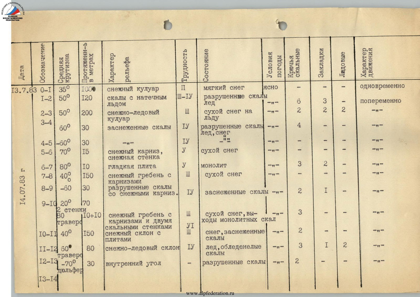
| Date | Designation | Average steepness | Length in meters | Terrain characteristics | Difficulty | Condition | Weather conditions | Rock anchors | Nuts | Ice screws | Movement character |
|---|---|---|---|---|---|---|---|---|---|---|---|
| 13.07.83 | R0–R1 | 35° | 1000 | snow couloir | I | soft snow | clear | - | - | 1 | simultaneous |
| R1–R2 | 50° | 120 | rocks with ice formations | III–IV | destroyed rocks, ice | -"- | 6 | 3 | 2 | alternating | |
| R2–R3 | 50° | 200 | snow-ice couloir | III | dry snow on ice | -"- | 6 | 3 | - | -"- | |
| R3–R4 | 60° | 30 | snowy rocks | IV | destroyed rocks, ice, snow | -"- | 4 | - | - | -"- | |
| R4–R5 | 60° | 30 | snowy rocks | IV | destroyed rocks, ice, snow | -"- | - | - | - | -"- | |
| R5–R6 | 70° | 15 | snowy cornice, snowy wall | V | dry snow | -"- | - | - | - | -"- | |
| R6–R7 | 80° | 10 | smooth slab | V | monolith | -"- | 3 | 2 | - | -"- | |
| 14.07.83 | R7–R8 | 40° | 150 | snowy ridge with cornices | III | dry snow | -"- | - | - | - | -"- |
| R8–R9 | 60° | 30 | destroyed rocks with snowy cornices | IV | snowy rocks | -"- | 2 | 1 | - | -"- | |
| R9–R10 | 20° | 70 | snowy ridge | IV | snowy rocks | -"- | 2 | 1 | - | -"- | |
| 80° | 10+10 | snowy ridge with cornices and two rocky walls | VI | dry snow, monolithic rock outcrops | -"- | 3 | - | - | -"- | ||
| R10–R11 | 40° | 150 | snowy slope with slabs | III | snow, snowy rocks | -"- | 2 | - | - | -"- | |
| R11–R12 | 60° | 80 | snow-ice slope | IV | ice, icy rocks | -"- | 3 | 1 | 2 | -"- | |
| R12–R13 | 70° | 30 | inner corner | III | destroyed rocks | -"- | 2 | - | - | -"- | |
| R13–R14 | 50° | 100 | ridge with cornice | III | loose snow | clear | - | - | - | alternating | |
| R14–R15 | 15° | 100 | ridge, hollow | I | hard snow | -"- | - | - | - | simultaneous | |
| R15–R16 | 20° | 60 | snowy saddles with cornices | II | loose snow | -"- | - | - | - | alternating | |
| R16–R17 | 50° | 80 | snowy ridge with cornices | III–IV | loose snow | -"- | - | - | - | -"- |
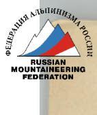

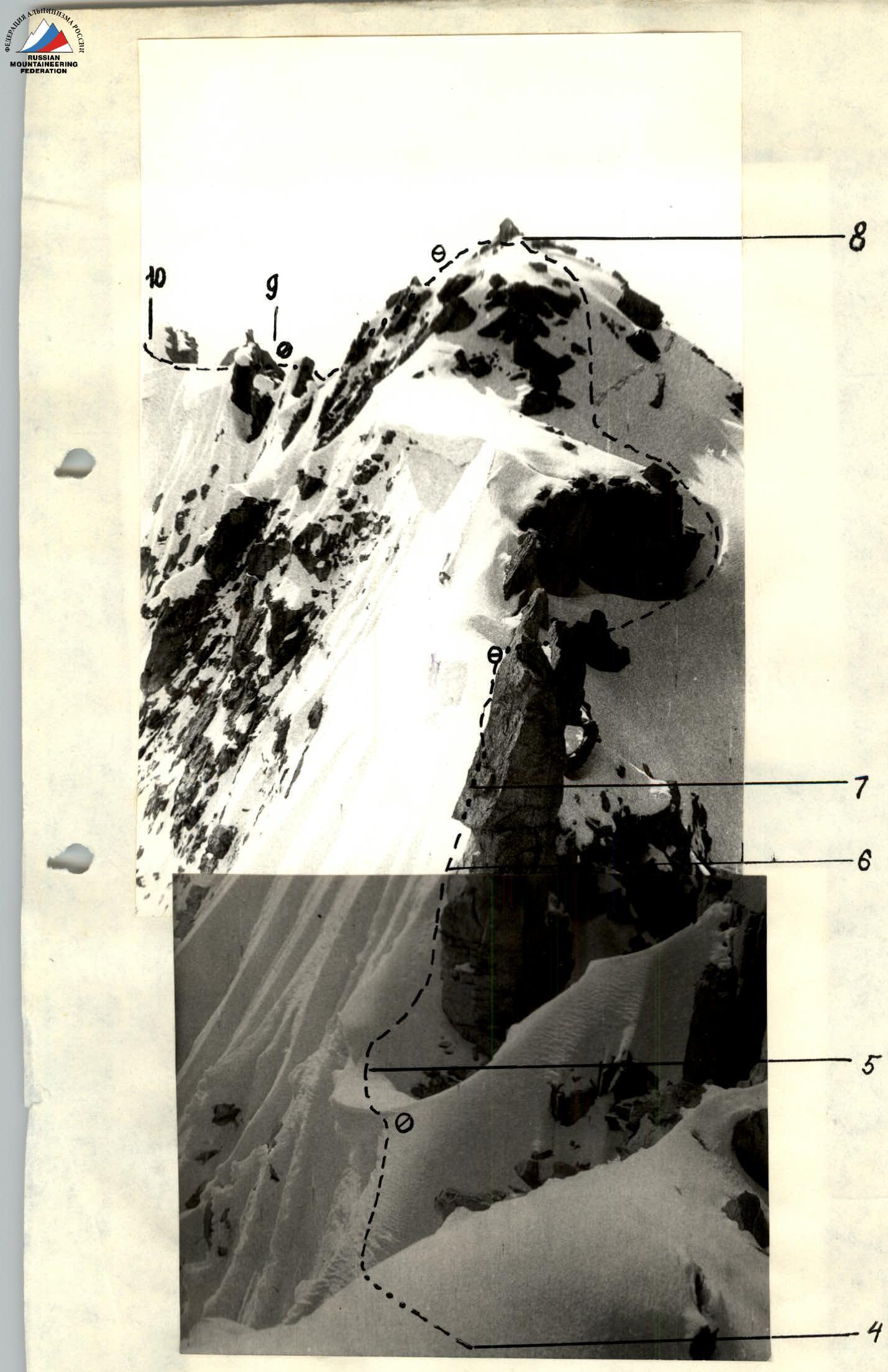
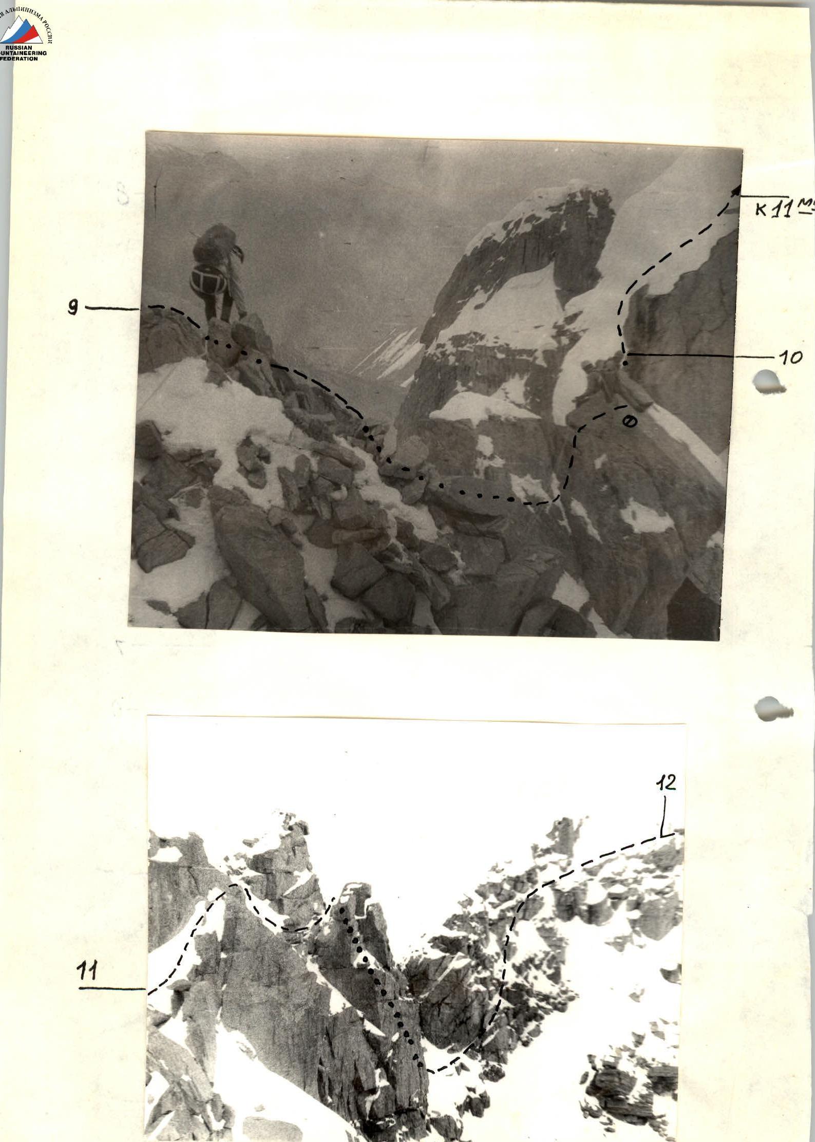 Photo 6. Summit of peak Dostoevsky. Taken from point I on July 15, 1983, at 11:00. Distance ≈ 2 km, height ≈ 4700 m, lens "Industar-55".
 UIAA scheme. Scale: 40 m, 8 mm. Overnight stay 19:00–6:00 on July 14, 1983. Peak Dostoevsky 16:00.
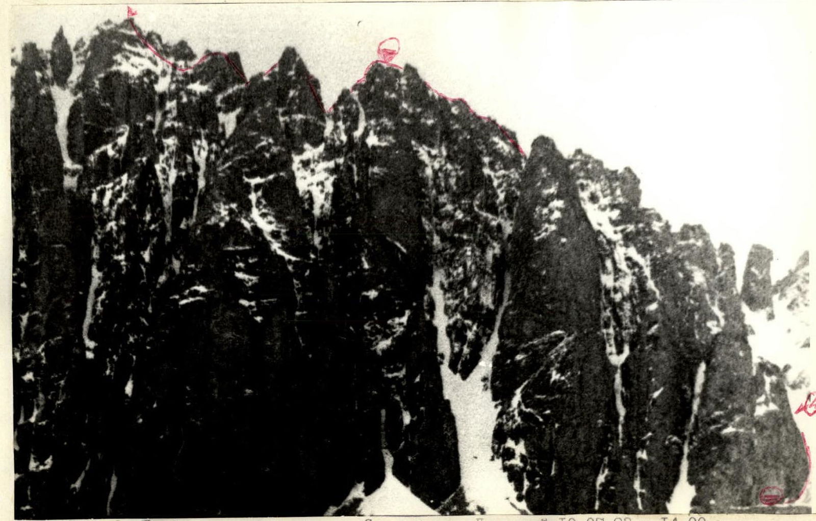 Photo 2. Route profile from the left. Taken from peak Domashny on August 10, 1983, at 14:00. Distance ≈ 4 km, height ≈ 4300 m, lens "Industar-55". — group route.