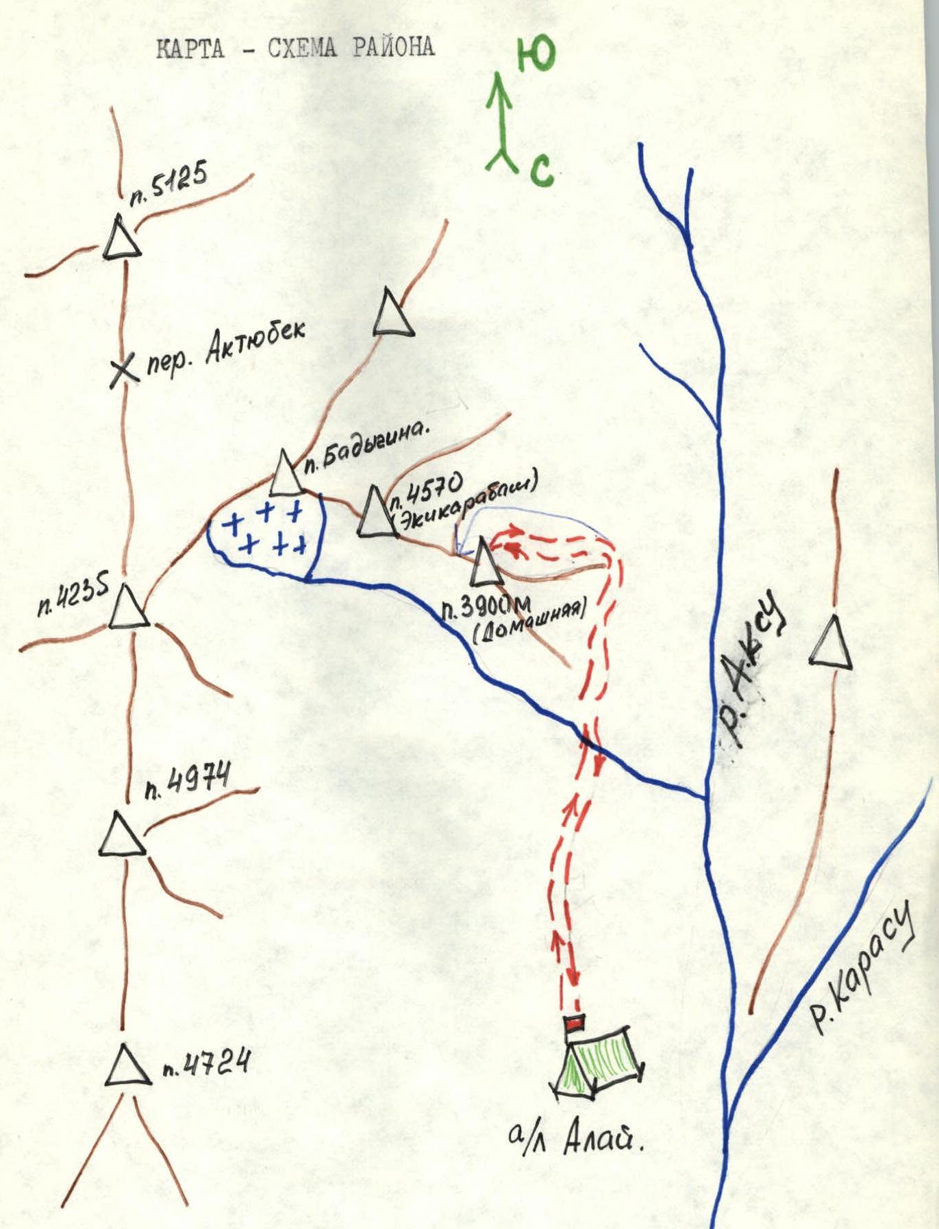
Brief Description of the Approach to the Route
From the base camp, descend to the confluence of the Ak-su and Kara-su rivers and cross two bridges to a large meadow. It takes 1 hour from the base camp.
Then, proceed up the right gorge along the scree slopes of the Northeast ridge. Exit through a steep scree couloir to the saddle of the Northeast ridge under the base of the Northeast wall. Here, a tent can be set up on a scree shelf. It takes 3 hours from the base camp.
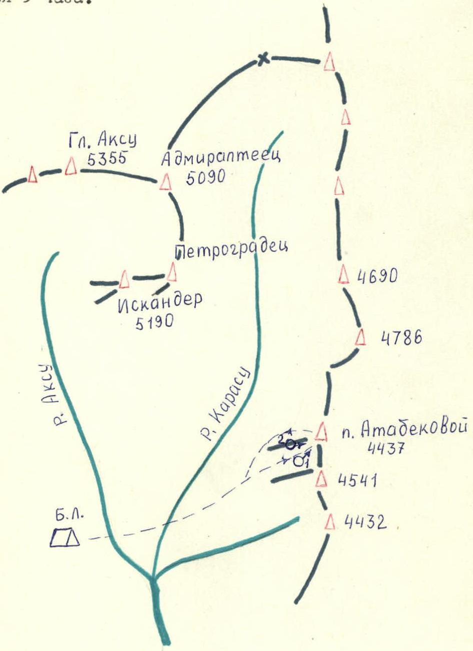
Map of the area. Route diagram. In UIAA symbols on p. Atabekova (4437) via N.E. wall 4A cat. diff. (landmark).


| Designation | Average steepness | Length m | Character of relief | Difficulty | Condition | Weather conditions | Rock | Bolts | Ice |
|---|---|---|---|---|---|---|---|---|---|
| 0–1 | 60 | 10 | Crack | 4- | Destroyed | Good | 1 | 1 | |
| 1–2 | 45 | 25 | Walls, shelves | 3 | Monolith | -"— | 2 | – | |
| 2–3 | 50 | 40 | Inner corner, slab | 3+ | Monolith | -"— | 3 | 2 | |
| 3–4 | 45 | 40 | Slabs, couloir | 3 | Snow-covered | -"— | 5 | – | |
| 4–5 | 60 | 40 | Walls, inner corner | 4 | Monolith | -"— | 6 | 1 | |
| 5–6 | 80 | 20 | Wall | 5 | Monolith | -"— | 4 | – | |
| 6–7 | 40 | 30 | Oblique shelf | 3- | Destroyed | -"— | 2 | – | |
| 7–8 | 80 | 10 | Crack | 5 | Monolith | -"— | 5 | – | |
| 8–9 | 30 | 40 | Oblique inclined shelf | 4- | Monolith | -"— | 6 | 1 | |
| 9–10 | 50 | 60 | Oblique shelves | 3 | Snow, ice, scree | -"— | 4 | – | |
| 10–11 | 70 | 35 | Oblique corner, shelf-niche | 4+ | Scree and monolith | -"— | 4 | – | |
| 11–12 | 50 | 35 | Snow couloir | 4- | Snow, ice, scree shelf | -"— | 5 | – | |
| 12–13 | 50 | 90 | Snow-ice couloir | 4- | Snow, ice, scree shelf | -"— | 8 | – | 2 |
| 13–14 | 60 | 40 | Monolith, frontal | 3+ | Monolith | -"— | 3 | – | |
| 14–15 | 10 | 130 | Ridge | 2 | Destroyed, snow-covered rocks | -"— | – | – |
July 2, 1983

General photo of the route. Taken on July 10, 1983, shooting point No. 1, H = 3950 m.
Brief Explanations for the Table of Main Route Characteristics
Sections
R0–R1 Beginning of the route from a scree shelf to the right of the saddle, from it up a vertical crack to a shelf.
R1–R2 Then along not very steep walls and an inner corner to an inclined scree shelf.
R2–R3 Further up to the right along an inner corner and a slab to a narrow scree shelf.
R3–R4 From here, move along the shelf to the right and up, crossing a snow-covered couloir.
R4–R5 Along a system of small but steep walls and inner corners (live rocks!) approach under a rusty rock wall with a small number of cracks.
R5–R6 Up the wall, move up and to the left to the base of an inner corner.
R6–R7 Along an oblique shelf 25–30 m to the right.
R7–R8 10 m up a narrow crack.
R8–R9 Traverse 10 m to the right, descend along an oblique shelf to the right to a shelf under overhanging walls 3 m.
R9–R10 Along oblique snow-covered shelves 60 m to the right and up to an inner corner.
R10–R11 Along a destroyed inner corner 35 m to the right to a small shelf.
R11–R12 From the shelf to the left along an icy inner corner to a rock shelf.
R12–R13 85–90 m up a steep snow-ice couloir (using ice screws and crampons) — exit to the ridge.
R13–R14 Along the ridge 40 m along monolithic rocks with small holds — exit to a gendarme.
R14–R15 From the gendarme along destroyed, partly icy and snow-covered rocks of the ridge 120–130 m — exit to the summit.
Ascent Passport
- Rock class.
- Pamir-Alay, Ak-Su gorge.
- Peak Domashny 3900 m from the South.
- Estimated cat. diff. 2B rock.
- Height difference 300 m, length 600 m, average steepness of the route 40°.
- Pitons hammered — 6 pieces.
- Travel hours — 7.
- Leader — School N.I., 3rd sports category.
Participants:
- Vaisberg E.I., 1st sports category.
- Sytnik D.N., 2nd sports category.
- Pyshkin A.V., 2nd sports category.
- Coach: Prikhodchenko Alexander Ivanovich, CMS.
- Departure to the route on August 10, 1984, return on August 10, 1984.
Avangard gatherings, Sumy city
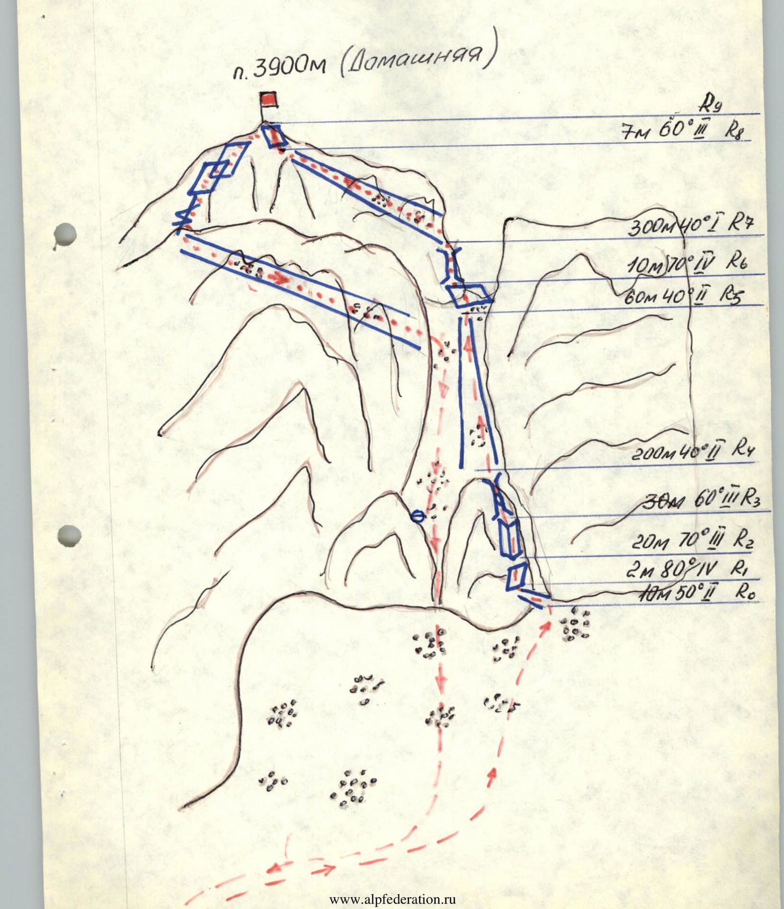
Brief Explanation for the UIAA Diagram by Sections of the Ascent to v. Domashnyaya 2B cat. diff. OR
R0 — Inclined wide rock crack leading up to the left, turning into a wall.
R1 — Wall, monolith, with characteristic small holds.
R2 — Inner corner, 20 m, goes up to the left. Passed while sticking to its left side, piton belay.
R3 — Oblique crack leading to a wide scree couloir, piton belay. Exit up to the right from under the plug to a scree shelf under the wall to the right of the couloir.
R4 — Scree couloir leading to a gap in the ridge. Move while sticking to its right side.
R5 — Scree shelf, inclined, exit along it to the right of the ridge.
R6 — Ascent along a chimney with an exit to a scree couloir. Danger of live rocks. Piton belay.
R7 — Scree couloir. Simultaneous movement, sticking to the right side of the couloir.
R8 — Inclined slabs leading out of the couloir to the summit.
Approach to the Start of the Route:
- From the base camp to a green hill near the northwest ridge (1 hour)
- Then under the western walls of v. Domashnyaya (1 hour)
- Along the scree under the southern walls (1.5 hours)
The start of the route is between two green juniper trees at the entrance to the rock gates.
Passage of the Route:
- Along a wide scree crack to the left (R0)
- Not reaching the end of the crack ≈ 10 m, along a rock with a black streak and then along an inner corner (R2)
- Exit from under the plug to the right to a scree shelf 2×1 m
- Then along a crack (R3) to a wide scree shelf leading to the saddle of the eastern ridge (R4)
- Bypass the gendarme to the right along a shelf (R5)
- Then along a chimney (R6) — exit to a wide platform (R7)
- From the platform along small shelves to the second scree couloir leading to the summit
- At the end of the couloir along a rock wall (R8) — exit to the summit
Descent from the Summit:
- To the right of the ascent couloir along shelves down
- With a descent along a crack to the left down — 60 m
- Then to the left into a scree couloir going down 200 m with a turn to the right — 200 m, exiting to the start of the route
- At the end of the couloir, a rappel 30 m and a sports descent 15 m
- Then along the scree down along the ascent path.
| Date | Designation of section | Average steepness | Length in meters | Character of relief | Difficulty | Condition | Weather conditions | Pitons | Character of movement | Time |
|---|---|---|---|---|---|---|---|---|---|---|
| 10.08.84 | R0 | 50° | 10 | Rock crack | 1 | Dry rocks | Clear | – | Simultaneous | Departure from camp at 7:00 |
| R1 | 80° | 2 | Wall | 4 | -"— | -"— | – | Alternate | ||
| R2 | 70° | 20 | Inner corner | 3 | -"— | -"— | 2 | -"— | ||
| R3 | 60° | 30 | Crack | 3 | -"— | -"— | 2 | -"— | ||
| R4 | 40° | 200 | Scree | 1 | -"— | -"— | – | Simultaneous | Arrival at the route at 10:00 | |
| R5 | 40° | 60 | Scree shelf | 2 | -"— | -"— | – | Alternate | ||
| R6 | 70° | 10 | Chimney | 4 | -"— | -"— | 2 | -"— | ||
| R7 | 40° | 300 | Scree | 1 | -"— | -"— | – | Simultaneous | Arrival at the summit at 13:00 | |
| R8 | 60° | 7 | Inclined slabs | 3 | -"— | -"— | – | Alternate | Return to camp at 14:20 |
UIAA Diagram