PASSPORT
I. Category of first ascents
-
Pamir-Alay, Ak-Su valley
-
Peak A. Blok, 5229 m, via West Face
-
Proposed category 6B, first ascent
-
Height difference of the route 760 m, "wall section" 688 m, length — 965 m. Length of sections with category difficulty 5–6 — 805 m, of which category 6 — 425 m. Average steepness of the wall — 78 ± 80°
-
Pitons driven:
- rock: 119 (driven), 40 (left)
- bolt: 32 (driven), 12 (left)
- protection devices: 187 (driven), 60 (left)
- ice screws: 2 (driven)
- "sky-hook" type aid used: 28
-
Team's total climbing time 82.5 hours; 7 days and one day of preparation
-
Night bivouacs: 1st and 2nd — sitting and four in hammocks; 3rd – 5th — four in tent, four in hammocks; 6th — sitting
-
Team leader: Kazbek Shakimovich Valiev, Master of Sport of the USSR
Team members:
- Yuri Alexandrovich Gorbunov, Candidate Master of Sport
- Grigory Evgenievich Lunyakov, Master of Sport
- Yuri Mikhailovich Moiseev, Master of Sport
- Sergey Genrikhovich Samoilov, Candidate Master of Sport
- Vladimir Ivanovich Suviga, Master of Sport
- Zинур Shagabutdinovich Khalitov, Master of Sport
- Viktor Ivanovich Yakunin, Candidate Master of Sport
- I. O.
-
Team coach: Ervand Tikhonovich Ilyinsky, Master of Sport of the USSR, Honored Coach of the USSR
-
Approach to the route: July 18, 1986 (preparation day)
Summit – July 25, Descent – July 26
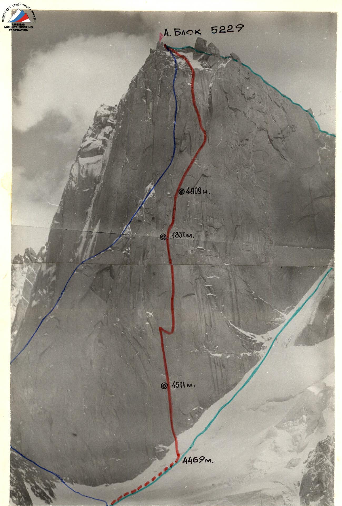
GENERAL PHOTO OF THE SUMMIT: — TEAM'S ROUTE — DESCENT PATH — "ZENIT" TEAM'S ROUTE (MOSCOW) July 4, 1986, 14:00. Photo taken with "Zenit-E" and "Helios-55". Height of shooting: from ~2000 m to 4200 m. Shooting point 2.
Route description by sections
R1–R2 — Straight up, and then up to the left under the cornice. Climbing is difficult, holds are in the form of small slabs-patches, unreliable. (photo 1)
R2–R3 — The cornice is bypassed on the left in an internal, not clearly expressed angle, "cup", exit to a small ledge, overnight stay. (photo 2)
R3–R6 — From the bivouac up the chimney. The left edge hangs in places, in the upper part the chimney becomes wider, you can go in opposition.
R6–R8 — The chimney turns into an internal corner formed by:
- right side — steep monolithic wall,
- left side — overhangs with large blocks in the form of feathers. Right traverse along the wall 10–15 m and then pendulum right down to a small irregularity on the wall like a shelf and then traverse right 20 m to a small inclined shelf (photo 3–5). Above, the beginning of the inner corner is visible, going between the "eyebrows". Up the smooth wall into this inner corner (photo 6).
R8–R10 — The inner corner is formed by:
- right side — sheer monolithic wall,
- left side — overhangs. The corner is sharp. There is a deep slit from 3 to 20 cm. In the middle and upper parts, the corner is locked by cornices (photo 7–10).
R10–R11 — From the corner to the left under the cornice (photo 10–11) onto a shelf where a tent can be set up. Overnight stay. From the shelf to the right up the slit.
R11–R12 — Traverse right 10 m and up the wall into the inner corner forming a "niche".
R12–R13 — The "niche" is passed on the right side. The upper part is steep, rests against a cornice. Insurance point (2 bolts).
R13–R15 — Traverse under the cornice into a narrow chimney (large icicle) and up the chimney, which then turns into a slit, up (photo 12). To the right — a narrow long stepped shelf. Overnight stay.
R15–R16 — Further up the inner corner to the right, we approach the base of a large corner. A lot of ice.
R16–R17 — Up the corner and through the cornice to the left onto an inclined shelf. Everything is covered in ice.
R17–R18 — Along the shelf under the wall, traverse left 10 m, to a thin slit. Up the slit to its end and pendulum right onto another slit, up it.
R18–R19 — Further up to the left into the inner corner (photo 13).
R19–R20 — Up the inner corner and to the right, bypassing the cornice onto a small shelf.
R20–R21 — Further up to the left:
- first, small monolithic walls 8–15 m,
- then destroyed (not steep) rocks,
- exit to the ridge and further to the summit.