Ascent Passport
-
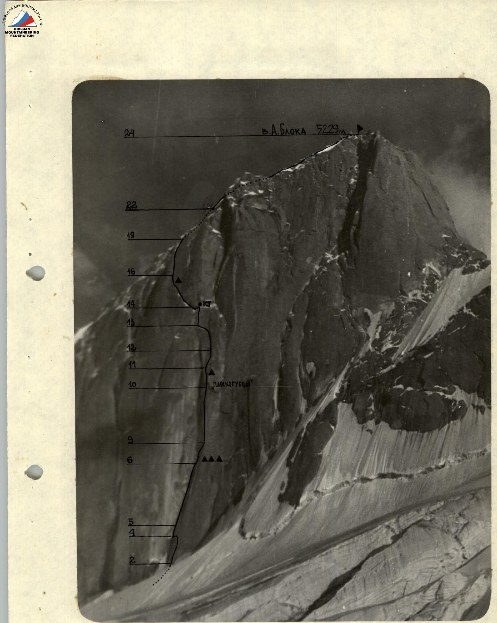
Peak, its height, route: p. A. Blok, 5229 m, via the Central Bastion of the North wall.
-
Area of ascent: Pamir-Alai, Turkestan Range, Ak-Su gorge.
-
Difficulty category: 5B (participants recommend 6th cat. diff.).
-
Route characteristics: length — height difference — average steepness of the route's wall section —
-
Pitons hammered:
| Rock | Chock stones | Bolt | Ice |
|---|---|---|---|
-
Time taken to reach the summit: 54 hrs.
-
Overnights on the route: 5 overnights (4 people on a suspended platform, 2 — in hammocks).
-
Team composition:
-
- Afanasyev A. E. — Candidate Master of Sports — team leader
-
- Yudalеvich V. F. — Candidate Master of Sports — participant
-
- Gusev D. P. — Candidate Master of Sports — participant
-
- Bolgov Yu. M. — Candidate Master of Sports — participant
-
- Koshkin A. E. — 1st sports category — participant
-
- Moskovskikh S. V. — 1st sports category — participant
-
Dates of departure and return: departure — July 12, 1984 return — July 18, 1984
-
Team coach: Yudalevich V. F.
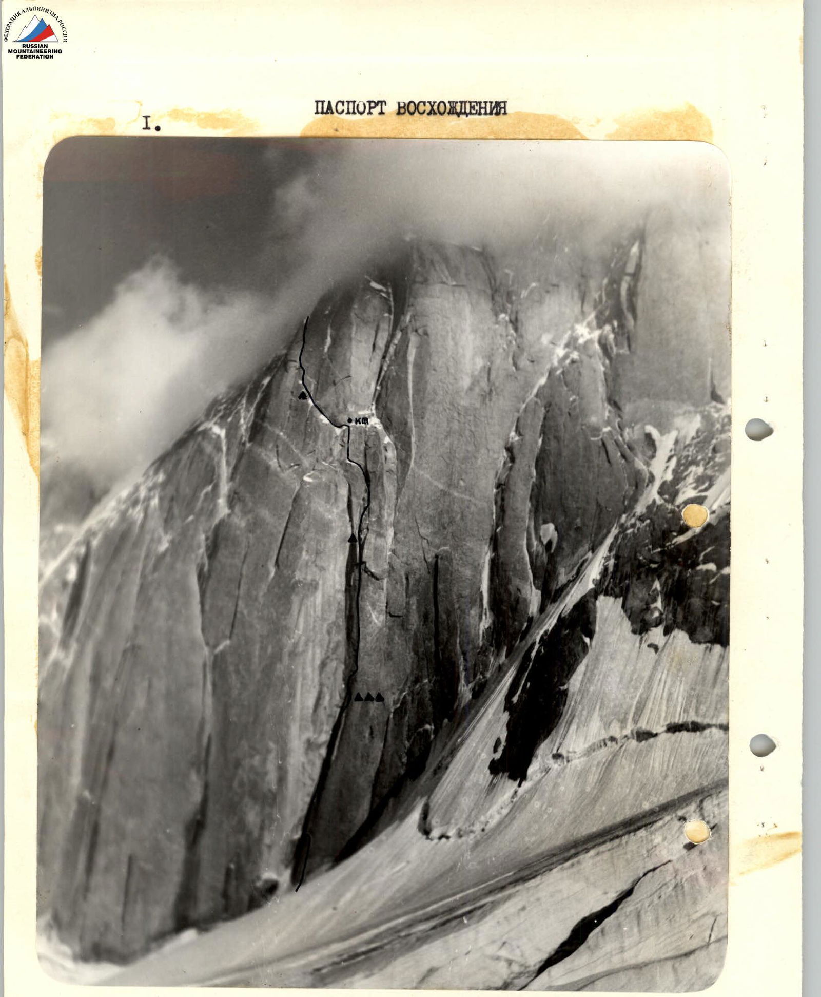
General photo of the wall section of the route
Brief description of the route by sections
| Section | Description |
|---|---|
| R0–R1 | Bergschrund 4 m 90°, crossed via a snow bridge. Insurance through ice screws. |
| R1–R2 | Ice slope 40 m 50°, traversed in crampons. Insurance through ice screws. |
| R2–R3 | Rock wall 10 m 75°, turning into a chimney. |
| R3–R4 | Chimney, местами залитый льдом, стенки камина заглажены. Insurance through chock stones and ice stoppers. Exit onto a ledge, iced over. |
| R4–R5 | Crack with width from 5 to 15 cm, leading up to the right and left towards an internal corner. After 10–12 m the crack leads out onto a slab. From here a 15 m pendulum left into an internal corner. Ascent via the internal corner by free climbing and "zaitsug". The internal corner is similar to R5–R6: 20 m, 80°. |
| R5–R6 | 60 m along an internal corner. The right wall of the internal corner has a steepness of 80°, smooth, without holds, the left wall is overhanging. Movement is possible along the crack in the internal corner, with a width of 0.5–30 cm. "Zaitsug" is periodically replaced by short sections of free climbing. The rocks are monolithic, overhanging in the upper part. |
| R6–R7 | Chimney, iced over, turning into an inclined iced crack, which leads out of the internal corner to the right onto a slab. Overnight hanging on a suspended platform and in hammocks. |
| R7–R8 | Slab 30 m 80°, drilled with holes for removable bolt hangers. Used "skyhooks" and 2 bolt hangers left by first ascenders. |
| R8–R9 | Series of tile-like cornices 10 m 95°, detached from the monolith, with cavities inside, местами — loose slabs. Transition to the right into a vertically running crack. |
| R9–R10 | Wall with a vertically running crack 90 m 87°, edges of the crack are mossy, slippery. The crack is traversed using artificial aids, short sections are traversed by free climbing, местами the wall нависает. Between 14:00 and 15:00 the waterfall starts working, and traversing the wall becomes impossible. |
| R10–R11 | Section starts у правого карниза «Плоскогубцев», a small overhang, crack similar to R9–R10: 40 m, 80°. |
| R11–R12 | Transition from left to right, crossing a small ledge with flowstone ice, 30 m 70°. Exit into an ice groove. Overnight in the middle of the section on the wall. |
| R12–R13 | Ice groove 40 m 70°, passage into a hole under a rock plug. Ice is hard, smooth. Exit onto a ledge. |
| R13–R14 | Along the ledge 15 m to the left under the wall with a crack in the middle part. Crack: — In the lower part — traversed using artificial aids, — In the upper part — free climbing in crampons (very difficult!). 30 m, 90°. Exit onto an iced-over slab. |
| R14–R15 | Wall 40 m 50°, in the lower part iced over, the middle part is wet, without holds, in the upper part — ice. |
| R15–R16 | Crack, traversed by free climbing, turning into a chimney, 40 m 55°, rocks are wet, местами лёд. |
Route diagram in UTLA symbols
scale 1:2000
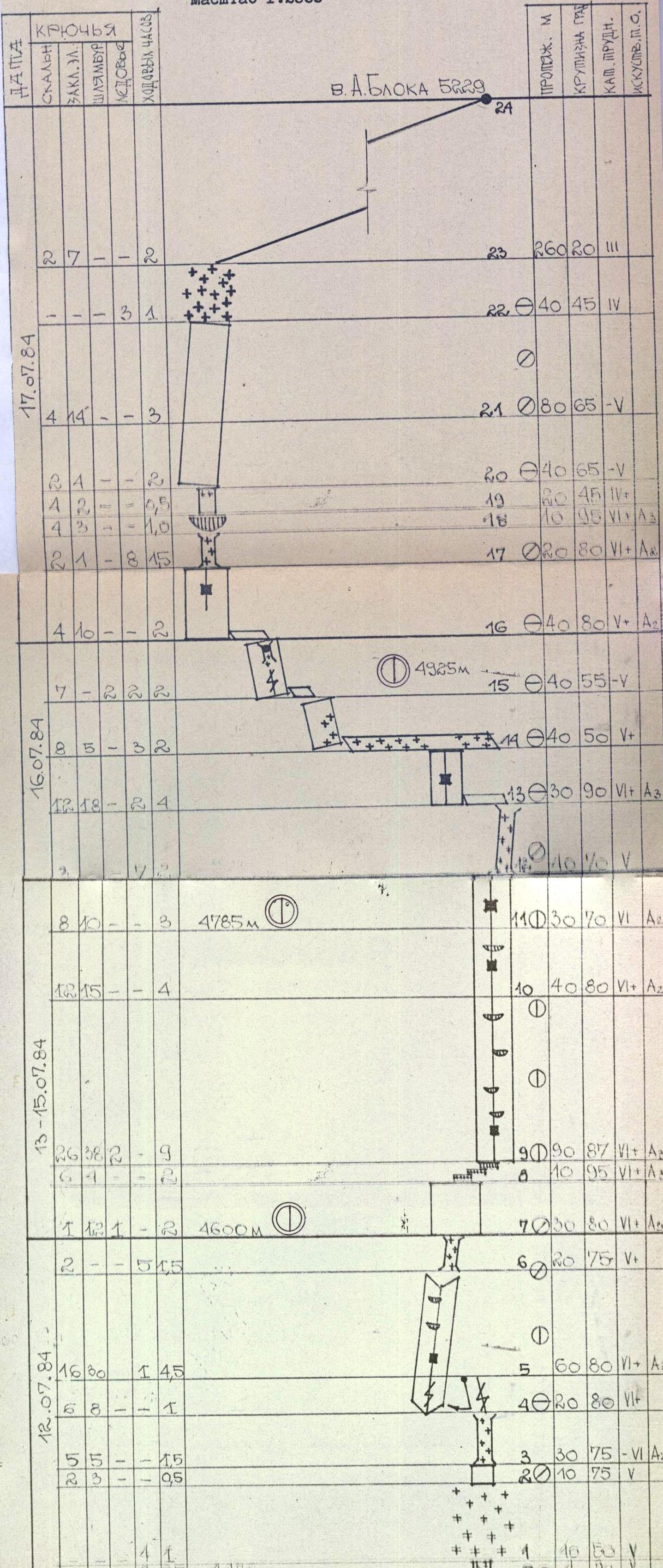
R16–R17 Transition to the left onto the wall, 40 m 80°. In the upper part "zaitsug".
R17–R18 The wall turns into a chimney, iced over, 20 m 80°, insurance through ice screws.
R18–R19 Exit through a cornice, along the left wall of the chimney, onto a ledge. At the exit there are very few cracks, 10 m 95°.
R19–R20 Rock wall 20 m 45°, in the upper part loose firn.
R20–R21 Rock slab with tile-like layers and a very limited number of cracks, 40 m 65°, difficult climbing in crampons.
R21–R22 80 m 65°, разрушенные скалы типа контрфорса, страховка в основном через закладные элементы.
R22–R23 Ice slope 40 m 45°, traversed in crampons, местами закрыт снегом. Exit onto the ridge.
R23–R24 Along an easy ridge, 260 m 20°, exit onto the summit. Rocks are разрушенные, много живых камней.
Descent
- Towards p. Ak-Su.
- 8 rappels along the rocks to a saddle.
- Then 12 rappels along an ice couloir to the glacier.
Technical photo of the route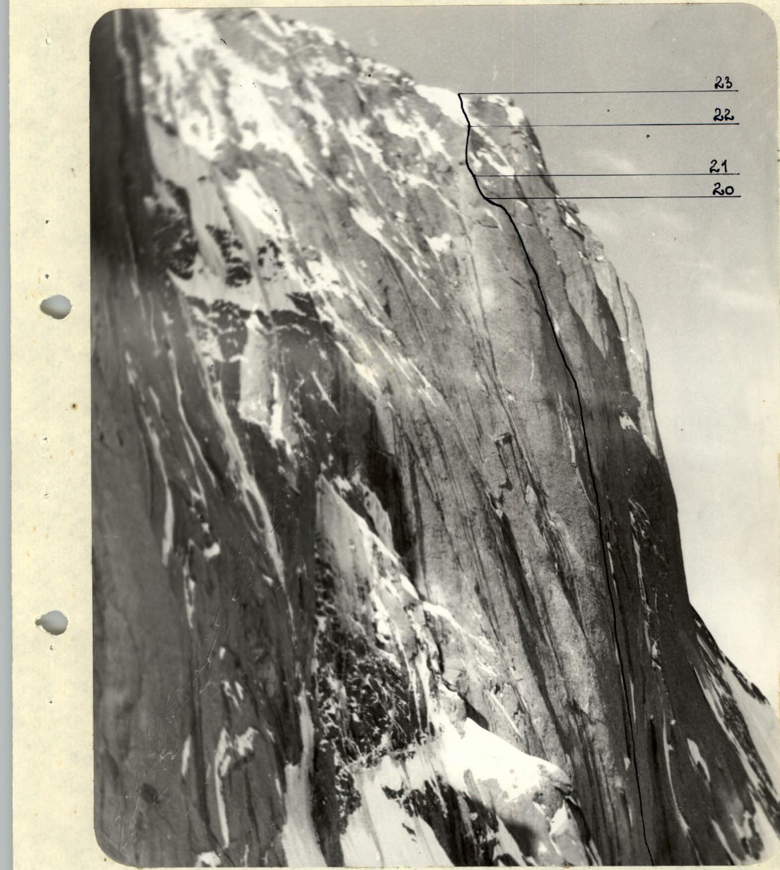
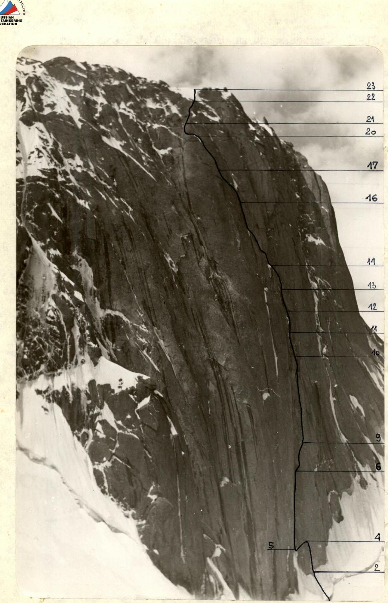
Route profile from the left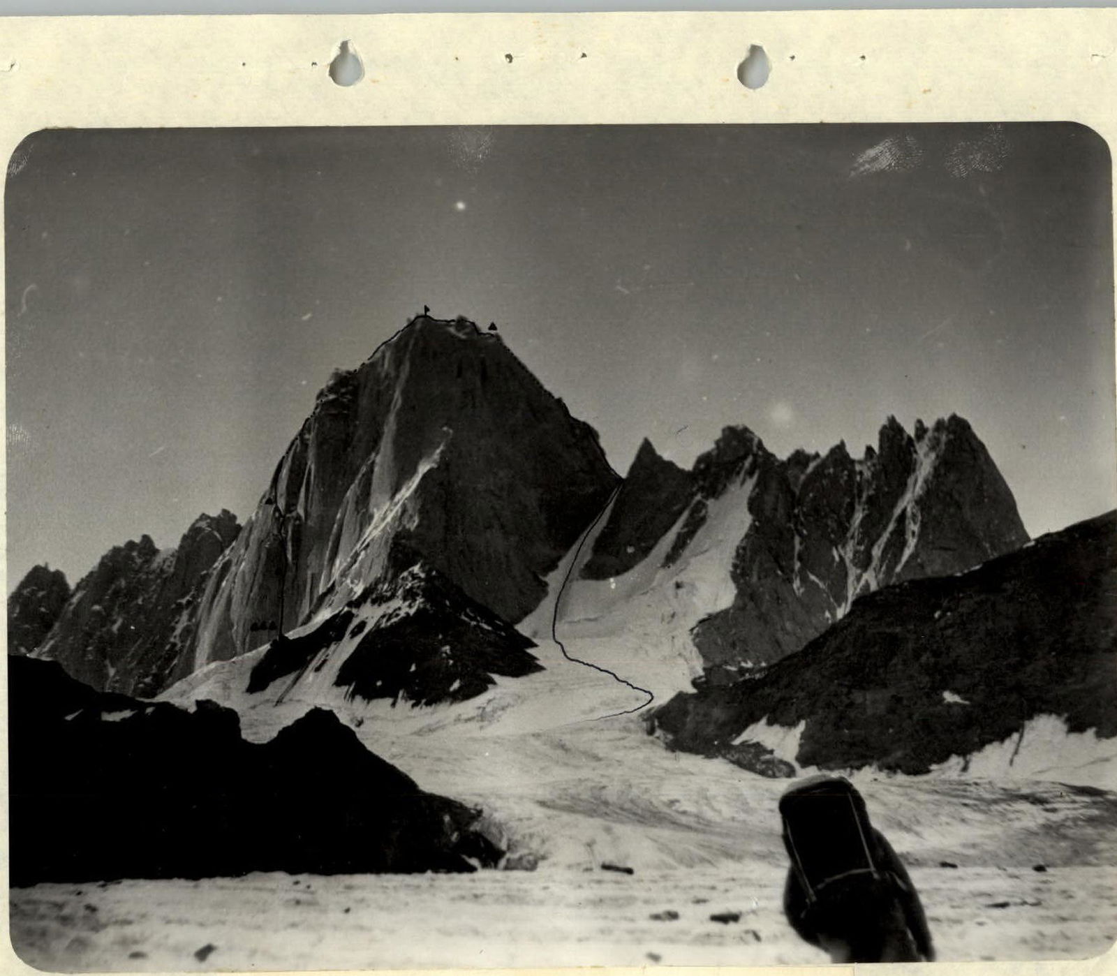
General view of p. A. Blok. Route profile from the right.