PASSPORT
- Technical class.
- Pamir-Alay, Turkestan Ridge, AkSu valley.
- Peak Blok (5239 m) via SW ridge.
- First ascent, 5B cat. difficulty is assumed.
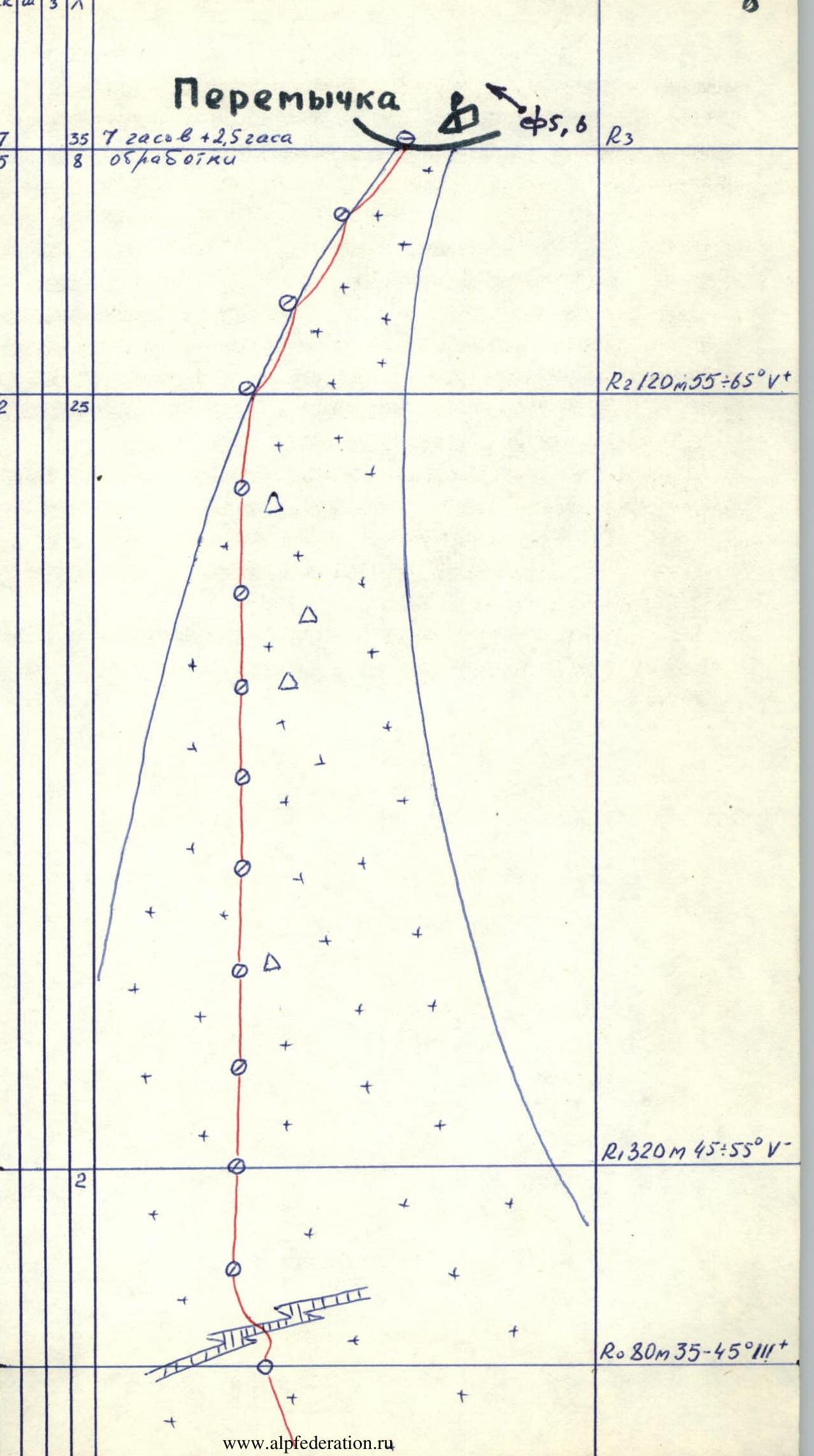
- Length of sections: 6th cat. difficulty — 55 m 5th cat. difficulty — 980 m Average steepness of main sections: 85–90° (4670–4770, 4800–4870, 5000–5040), 80–85° (4600–4670), all of 5–6 cat. difficulty.
- Pitons driven: rock, bolt, chocks, ice 54/14 2/2 60/3 35/0
- Travel time — 22.5 hours, days — 2.
- One overnight stay on an uncomfortable ledge.
- Leader — Petrichenko Nikolay Nikolayevich Master of Sports of the USSR Participant — Prokopovich Sergey Konstantinovich 1st sports category.
- Team coach Petrichenko Nikolay Nikolayevich Master of Sports of the USSR
- Approach to the route July 9, 1984.
On the summit July 10, 1984.
Return July 11, 1984.
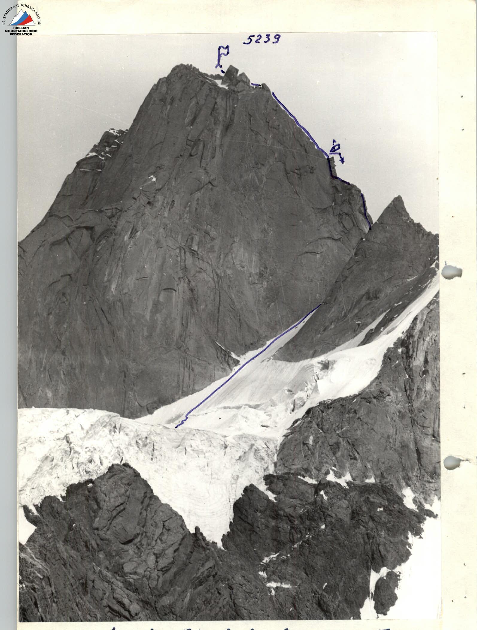 The team's tactical actions. The ascent route can be divided into two characteristic sections. The lower section up to the saddle is a 600-meter snow-and-ice slope with gradually increasing steepness, which reaches 65° in the last meters. Having a northern orientation and being screened from the eastern sun by the sheer NW wall, it begins to be lit by the sun not earlier than 12:00–13:00, and sections close to the wall — even by 14:00–15:00. Due to the high steepness and rigidity of the ice, crampons and ice axe do not provide speed and reliability of movement. In the second half of the day, ice debris falling from the NW wall near the summit is possible on the lower third of the section.
The upper section from the saddle to the summit is a combination of sheer walls and steep rocky ridges with a total length of 800 m. Predominantly smooth monolithic slabs prevail, cracks are often blind or winding, making them more suitable for chocks than for pitons. Near the summit, there are sections of flow ice. The ridge breaks off with cliffs on both sides, so the gendarmes have no bypasses. There are practically no loose stones, except for the pre-summit ridge, where there are also few of them. The key section of the route is the rock wall "Sphinx" — 200 m of cliffs from the saddle under the gendarme "Cheese Head".
Bivouacs lying down with a tent can be organized on the saddle (poor site), on the horizontal site of the gendarme "Cheese Head" and on the summit. Sitting bivouacs are possible under "Cheese Head" and above it every 80–100 m.
Movement schedule. Our pair overcame the ice section in 7 hours. The rocky ridge required 13 hours with two processed ropes. Since we did not have time to overcome the "Sphinx" wall on the first day and had the opportunity to hang only two ropes, the main load fell on the second day. Therefore, the group organized a bivouac on the descent at 23:00, which can only be afforded in the first half of summer with a full moon.
To optimize the movement schedule, it is recommended to process four ropes on "Sphinx", of which a pair can be left for descent, or, by extending the working day, strive to reach "Cheese".
Tactical movement scheme. On the ice section, the leader moved in crampons with the help of an ice axe and ice hammer. It is desirable for the lead climber to move without a backpack, have crampons and ice axe, as well as an ice hammer or ice axe for cutting steps at belay points. Belay through ice screws. The last three belay points are made on rocks, where rappel anchors are organized. The second climber is advised to move along the fixed ropes using a prussik.
On steep rock sections, the first climber went lightly, in galoshes. Belay — double rope through pitons and chocks. The second climber moved along the fixed rope using a ladder and prussik.
Communication with the base camp via "Vitalk" radio station is almost impossible. Only from the summit can you contact the base using a very good station. Our group communicated through observers, who used "Karat" for relaying. From the observers' camp, the group on the route is clearly visible through binoculars.
Descent along the ascent route. On the rocks, there are ready-made stations where it is only necessary to check the pitons and update the slings. For descent on ice, we recommend having an ice screw with a handle. The slings will be unreliable, as the ice has a flow texture and easily flakes off along the slope.
Our group carried out the descent in conjunction with the team of UkrSoviet DSO "Spartak" (leader S. Kalashin), with whom they met on the summit.
| 59 | 2 | 60 | 55 | 22.5 | zaca | 5239 |
|---|---|---|---|---|---|---|
| 41 | 2 | 50 | - | 1320006 | 1 | |
| 1 | - | 1 | - | R19–R200 III+ | ||
| 66 | 2 | - | 6 | POM5 | R18 40 м 85° V+ | |
| 2 | - | 1 | - | R17 40 м 55° V− | ||
| 2 | - | 3 | - | R16 40 м 65° V− | ||
| 1 | - | 3 | - | R15 40 м 65° V− | ||
| www.alp-federation.ru↗ |
Route description by sections
Approach to peak Blok along the right bank of the AkSu river to the moraine. Then along the ridge of the right moraine to the turn of the glacier and further along the talus and moraines to the slopes of the NW spur of peak Blok, separating the AkSu and Aktubek glaciers. The approach takes 5–6 hours.
From the observers' bivouac on the flat slope of the spur, exit to the lowering in the spur to the left of the icefall, from where along the broken glacier you can approach the snow plateau under the NW wall of Blok (1–1.5 hours).
Section R0–R1 From the bergschrund to the saddle, 13 ropes of snow-and-ice slope with gradually increasing steepness from 35 to 65°. Before the bergschrund, there are about 100 m of a steep snow slope of compacted avalanche snow.
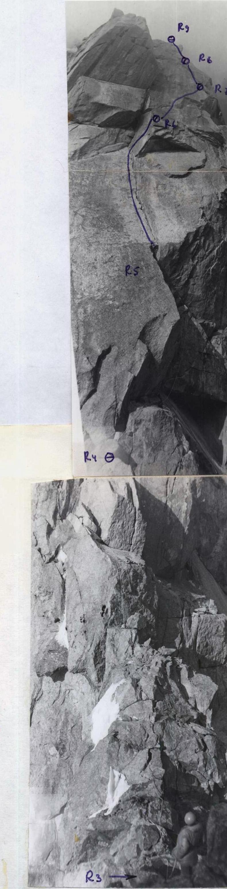
Section R3–R8. The "Sphinx" wall is a key section of the route. Smooth slabs and cornices. You need to move through the overhanging inner corner to the cleft (section R5), from where the further path becomes unambiguous. On section R6, movement on ladders along a blind crack leads to a bypass of a small overhang.
Section R10–R11. Gendarmes with characteristic weathering cavities are called "Cheese Head". The inner corner to the left of "Cheese" is not visible. You need to climb onto a ledge and go along it around the corner. Belay point R11 is poor, as the front participant is not visible and almost not audible. On the summit of "Cheese", there is a completely flat rocky site, an icy grotto under a large stone.
Section R12 — a wall with inclined clefts at first glance seems simple. However, the steepness here is close to sheer, and the edges of the clefts are smooth. Climbing turns out to be quite difficult, and chocks will be under lateral stress.
Section R13–R15. Rocky ridge with walls. Climbing is free and quite pleasant. The path is very logical and does not need additional description.
Section R16–R18. Not reaching 40 m to the gendarme "Tooth", you should go traverse to the right under the gendarme "Rhombus" and climb along a small couloir to the inner corner on the southern wall of "Rhombus". The corner has a cleft up to 15 cm wide and smooth sheer walls. There are practically no cracks for pitons; large chocks are needed. Climbing is by jamming hands and feet.
In our opinion, there is an option to bypass "Rhombus" on the left. From the saddle between "Tooth" and "Rhombus", you can rappel towards the NW wall, where a section of not steep but ice-covered rocks was visible, bypassing "Rhombus". If there is a lot of snow, this option will probably be preferable.
Section R19 is passed mainly to the right of the ridge. There are several small walls, and flow ice is encountered. The complexity of the section is about 3B cat. difficulty.
Descent from the summit along the ascent route.
Photo 3. Ascent route. Shooting point June 13, 1984, 17:00. H = 3800 m. Lens I-24/105 mm.
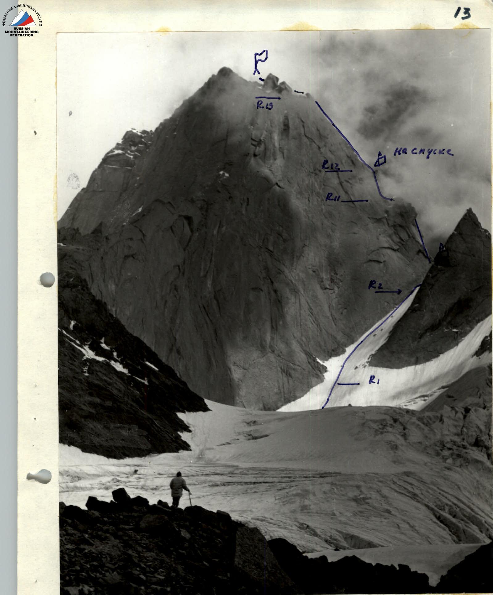
Photo 4. Lower part of the route. Shooting point September 14, 1984, 7:00. H = 4000 m. Lens I-24/105 mm.

Photo 6. Traverse along the "Cheese" wall. Shooting point July 11, 1984, 12:00. H = 4750 m. Lens I-24/105 mm.
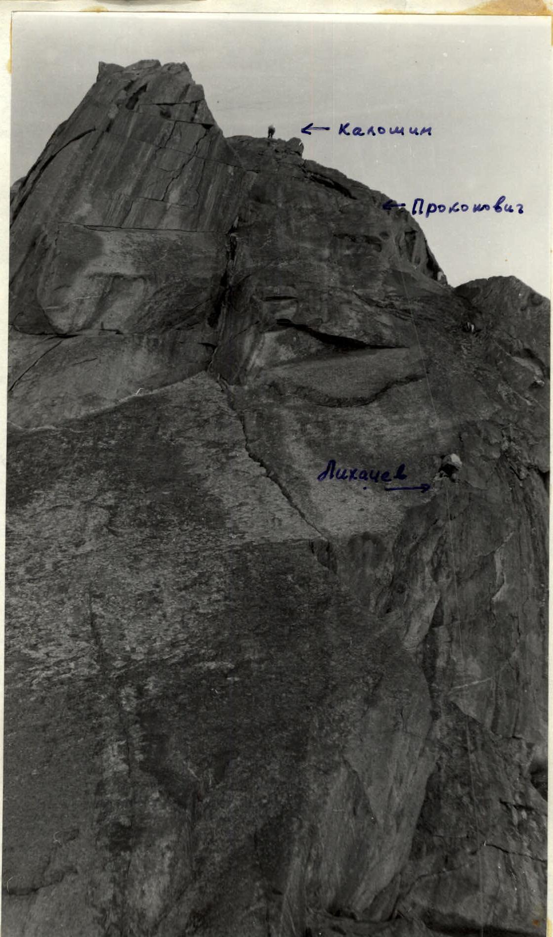
Photo 5. Under the "Sphinx" wall. Shooting point July 9, 1984, 19:00. H = 4750 m. Lens I-24/105 mm.