ASCENT DOCUMENT
- Technical category.
- Pamir-Alay, Turkestan Range, Ak-Su gorge.
- Peak 5239 (A. Blok) via the Western ridge.
- Proposed — 5B cat. diff., combined, second ascent.
- Height difference — 790 m, route length — 990 m.
Average slope of the route — 55°. Average slope of the icy part of the route — 50°. Average slope of the main rock part — 72°. Length of sections with 5th and 6th cat. diff. — 400 m.
- Number of pitons:
| rock | nuts | ice |
|---|---|---|
| 44 | 56 | 40 |
| 2 | 7 | 0 |
- Number of travel hours: a) to the summit — 20 b) on descent — 10.
- Number of overnight stays: a) on ascent — 2 b) on descent — 1.
All overnight stays were comfortable, in a tent.
- Leader: Shaginyan I.E. — Master of Sports of the USSR. Participants:
- Ginzburg S.A. — 1st sports category
- Gutsol A.F. — 1st sports category
- Makhnovetsky A.B. — 1st sports category. Coach: Kozlov Yu.E. — Master of Sports of the USSR.
- Approach to the route: July 22, 1984.
Summit: July 24, 1984.
Return: July 25, 1984.
I). The total number of pitons is in the numerator, the number used for ITD is in the denominator.
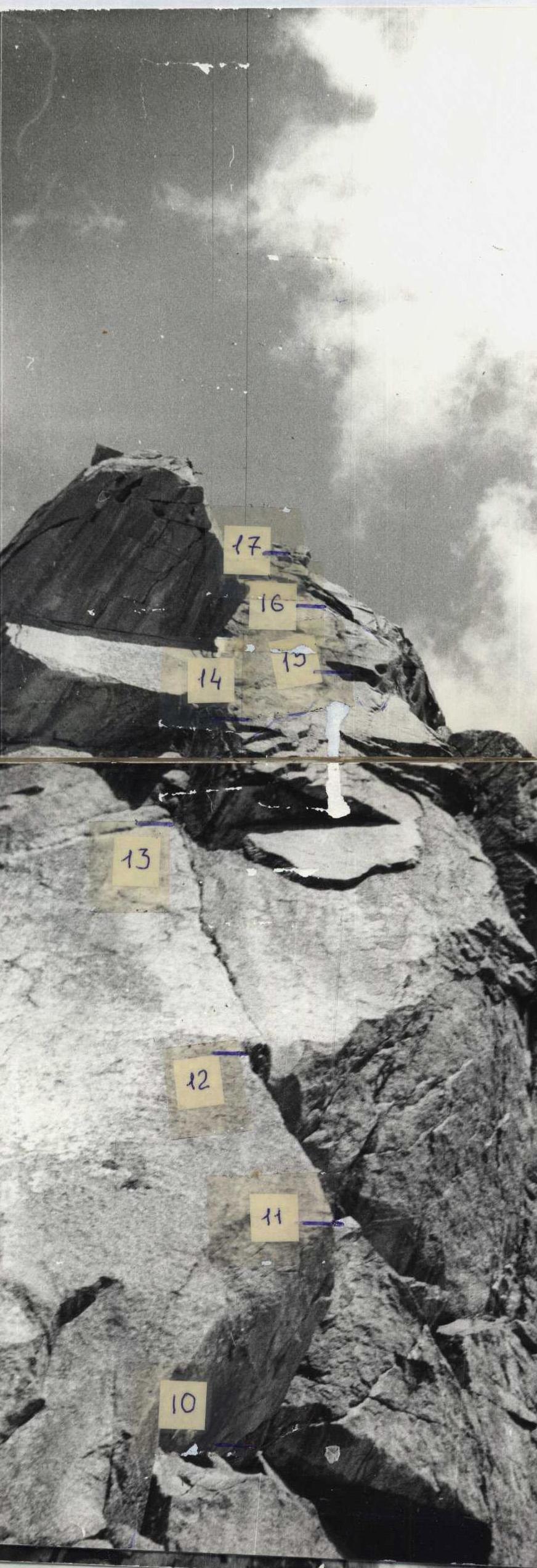
Photo #2. Distance 10–100 m. July 19, 1988, 13:00. Legend:
- ⑧ — section numbers,
- ② — overnight stay location numbers.
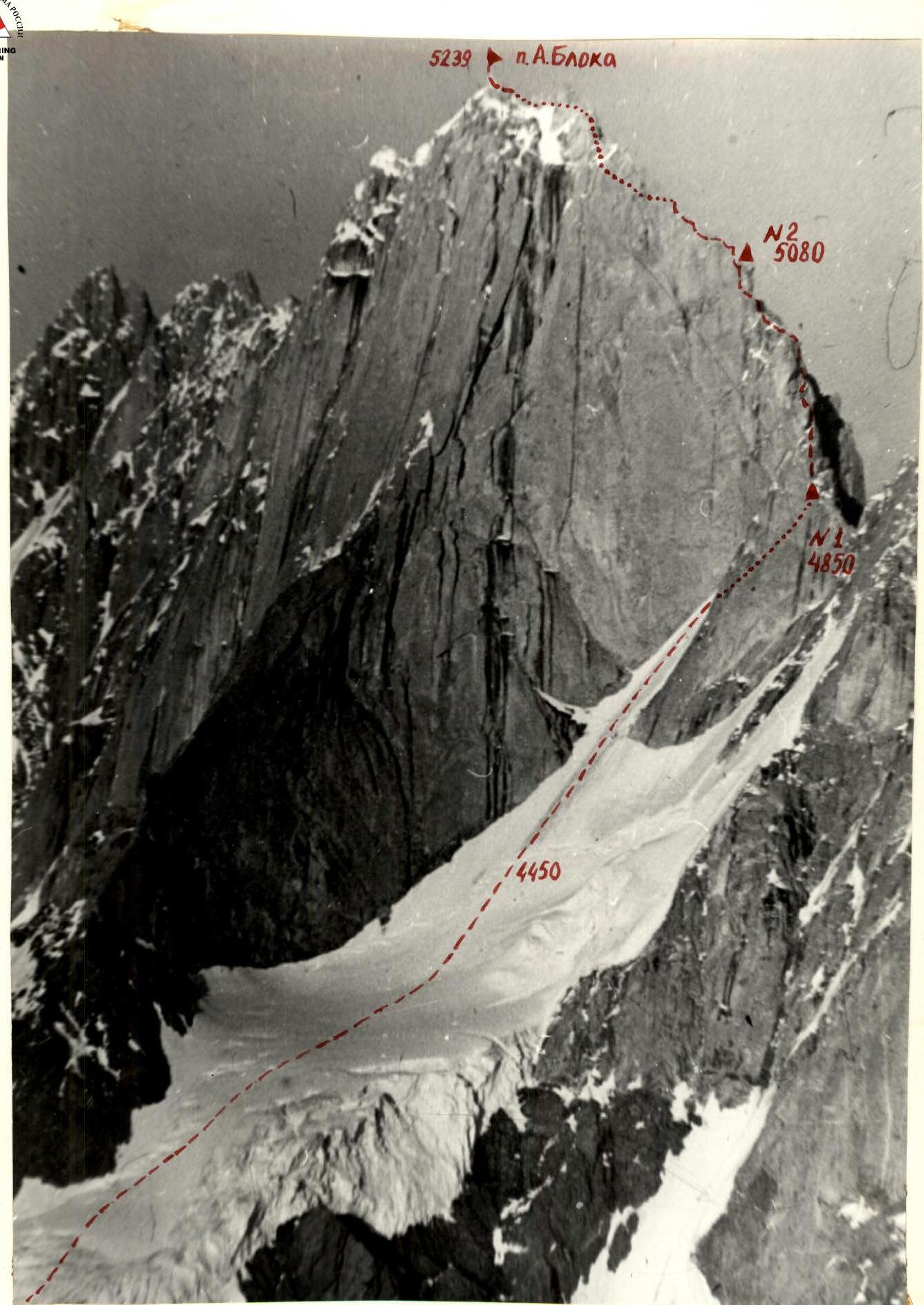
Photo #1. General view of the summit. Taken from the ridge between peaks Iskander and M. Iskander. Lens: "Yupiter-37A" (F=135). Distance — 4 km. Height — 4300 m. Date — July 10, 1984. Time — 19:00.
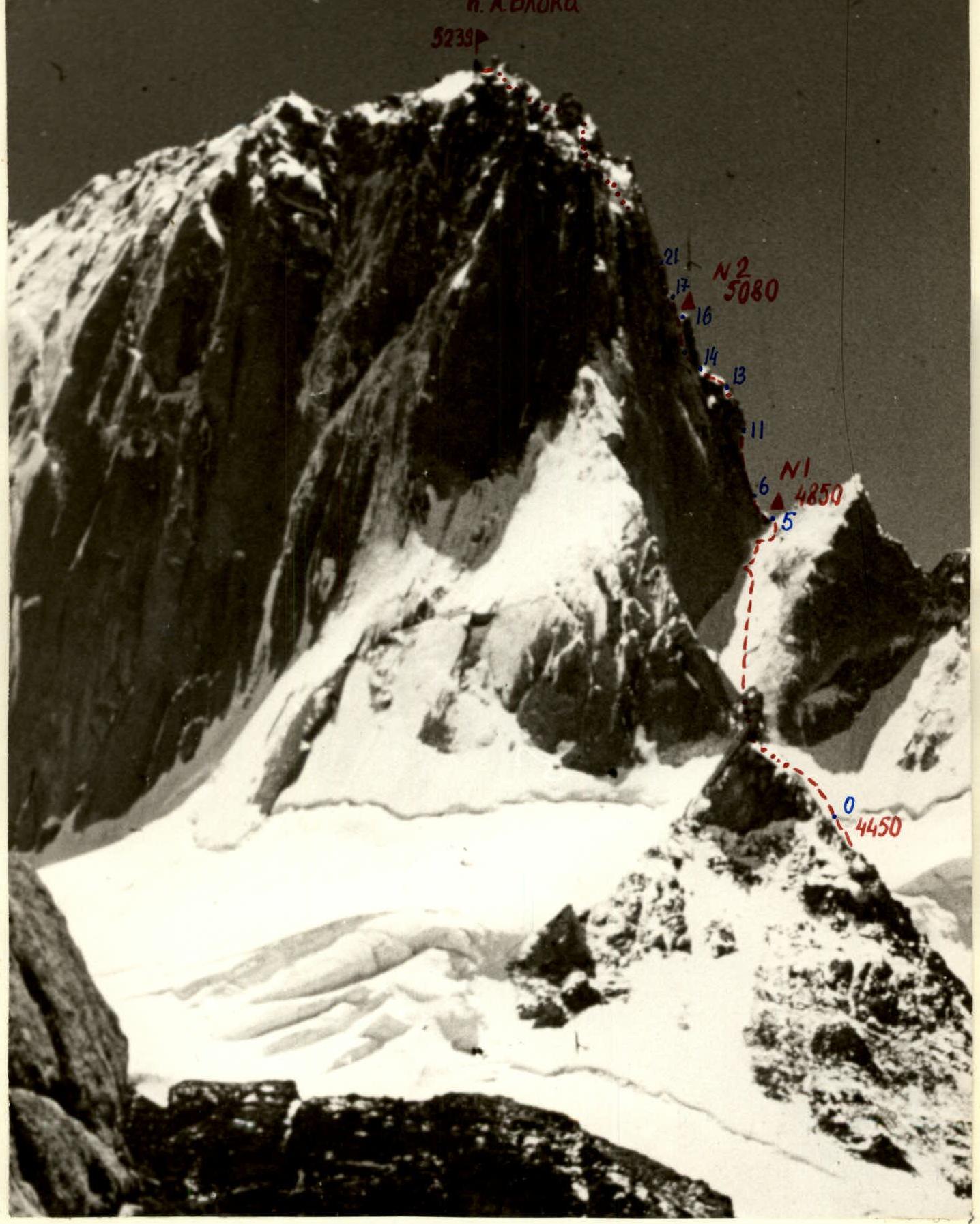
Photo #2. Profile of the route from the North. Taken from the Western ridge of peak 5125 (Aktyubek). Lens: I-26M (F=52). Distance — 2 km. Date — July 5, 1984. Time — 14:00.
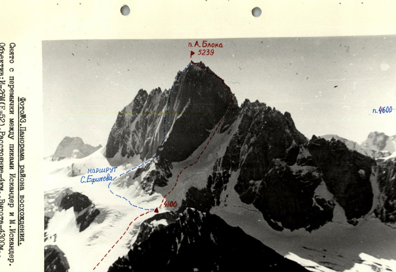
Photo #3. Panorama of the ascent area. Taken from the ridge between peaks Iskander and M. Iskander. Lens: I-26M (F=52). Distance — 4 km. Height — 4300 m. Date — July 10, 1984. Time — 20:00.
Tactical actions of the team
July 22. Snow-ice couloir. No spontaneous rockfalls were observed, there were practically no rockfall traces under the couloir. The group passed through the couloir from 9:00 to 15:00. Gutsol worked ahead (lower 9 ropes) and Ginzburg. Other participants moved along the fixed ropes. Rock part of the route. After rest and setting up a bivouac, the Ginzburg–Makhnovetsky team processed part of the wall (sections R5–R12; about three ropes) from 17:00 to 22:00. The wall has a western exposure and is well lit until 22:30.
July 23. The group passed the processed part of the route and the remaining part up to the "Gyr cheese" gendarme. Gutsol worked ahead. Section R16–R17 was processed.
July 24. The group ascended to the summit and descended to the tent on the "Gyr cheese" gendarme in 5 hours. Then the group descended to the ridge in 3.5 hours, where they spent the night (the group was on the ridge at 18:00).
July 25. Descent from the ridge to the bergschrund took the group 4 hours.
Route description by sections
R0–R5. Ice couloir with gradually increasing steepness, approximately 400 m long. Ice screws or ice axes are required to pass the upper part of the couloir. R5–R6. Steep, stepped ridge. R6–R7. Inner corner-chimney with ice remnants, ladders are required to pass. To the right of it is a characteristic cornish with an almost horizontal "ceiling". R7–R8. Inner corner-chimney, passed with ITD and ladders. R8–R9. Narrow crevice in the rusty wall, resting against an inner corner under a large cornish (huge icicle in the inner corner!). Large nuts fit well. R9–R10. Wall to the right of the crevice, passed on ladders, petal pitons are required. The section ends with a narrow shelf. R10–R11. Along a crack in the wall to the right and up with ITD and ladders. Petal and drill (2–3 pieces) pitons are required. R11–R12. Exit from under the cornish along a chimney by climbing. R12–R13. Wall of block structure is passed by free climbing. R13–R14. Simple wide ridge leading under the "Gyr cheese" gendarme with characteristic cavities. R14–R15. Inner corner leading from under the base of the "Gyr cheese" gendarme onto a rock shelf-plate under an overhang, which has to be traversed on all fours. R15–R16. Difficult inner corner in the northern wall of the gendarme, leading onto a large flat area of the "Gyr cheese" gendarme. Medium and large nuts fit well. R16–R17. Steep edge, the southern wall of which has a system of sloping cracks, along which there is an exit onto a sloping area. R17–R20. Along the left side of the ridge through a small wall under the next gendarme. R20–R21. Gendarme is bypassed on the left along a shelf with an exit into a narrow saddle of the ridge along an inner corner. R21–R22. Traverse along the right side of the ridge along a system of shelves, cracks and flakes under a large gendarme with characteristic edges and ridges. R22–R23. Inner corner-couloir (with snow and ice in the first half of summer) under a difficult inner corner in the wall of the gendarme (few holds). R23–R24. Pass behind the inner corner and climb up along a chimney formed by the wall and a fragment.
UIAA route scheme

R24–R25. Difficult icy wall. Section R23–R25 may be impassable with a large amount of snow and ice. In this case, the ascent to the gendarme should be done along the inner corner. R25–R26. Along a system of shelves and scree, interspersed with small walls, generally heading to the right — exit to a cairn located on a narrow ridge between two gendarmes, the right one (with a sharp top) being the summit. Descent via the ascent route.
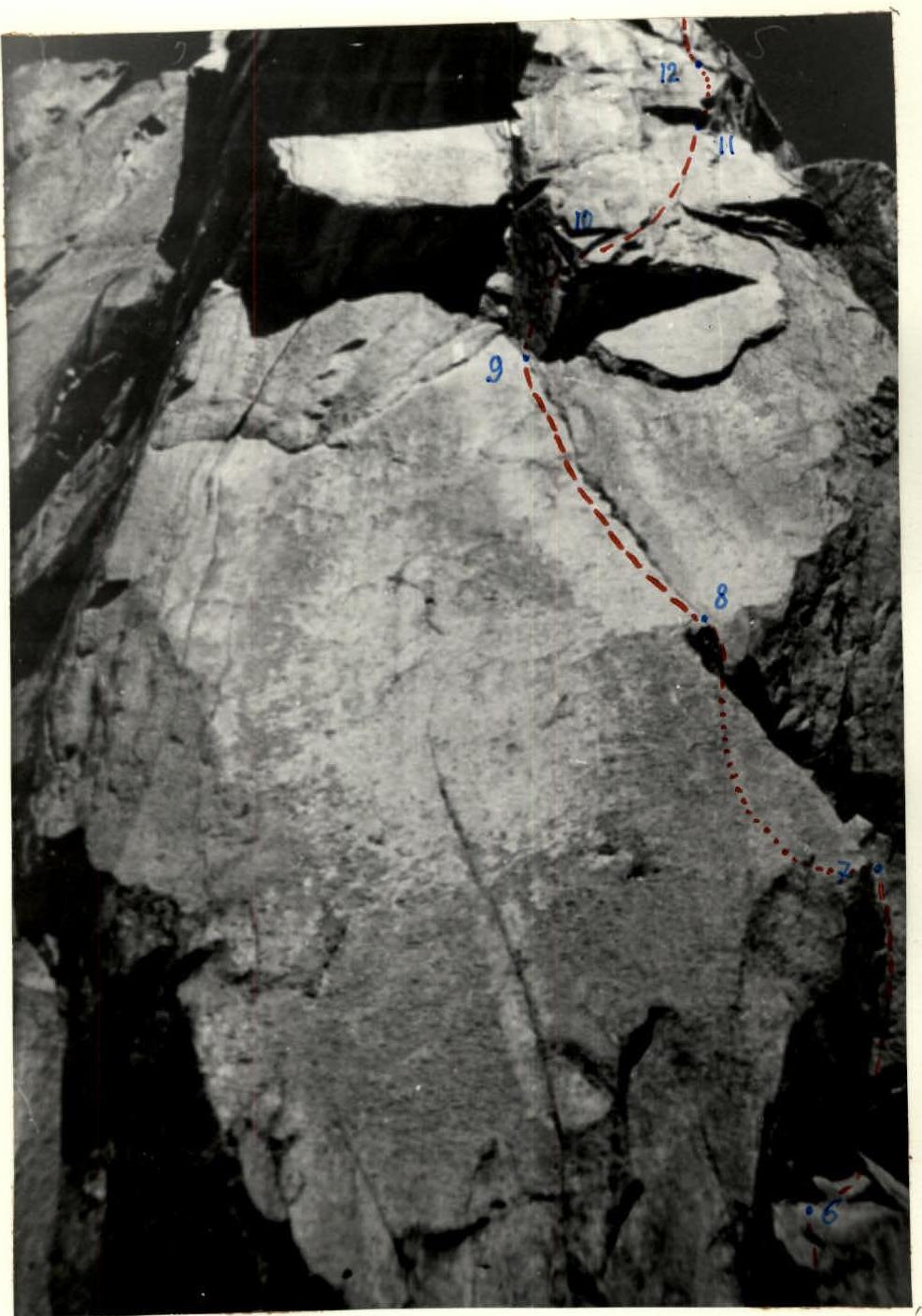
Photo #4. Technical photograph of the route (sections R6–R13). Taken from the first overnight stay location. Lens: I-26M (F=52). July 22, 1984, 18:00.
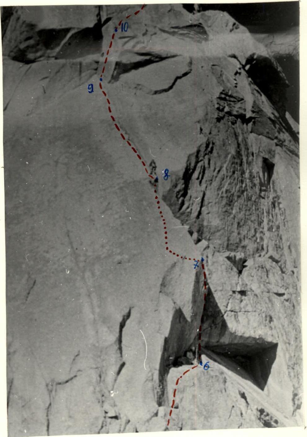
Photo #4a. Passage of sections R6–R8.
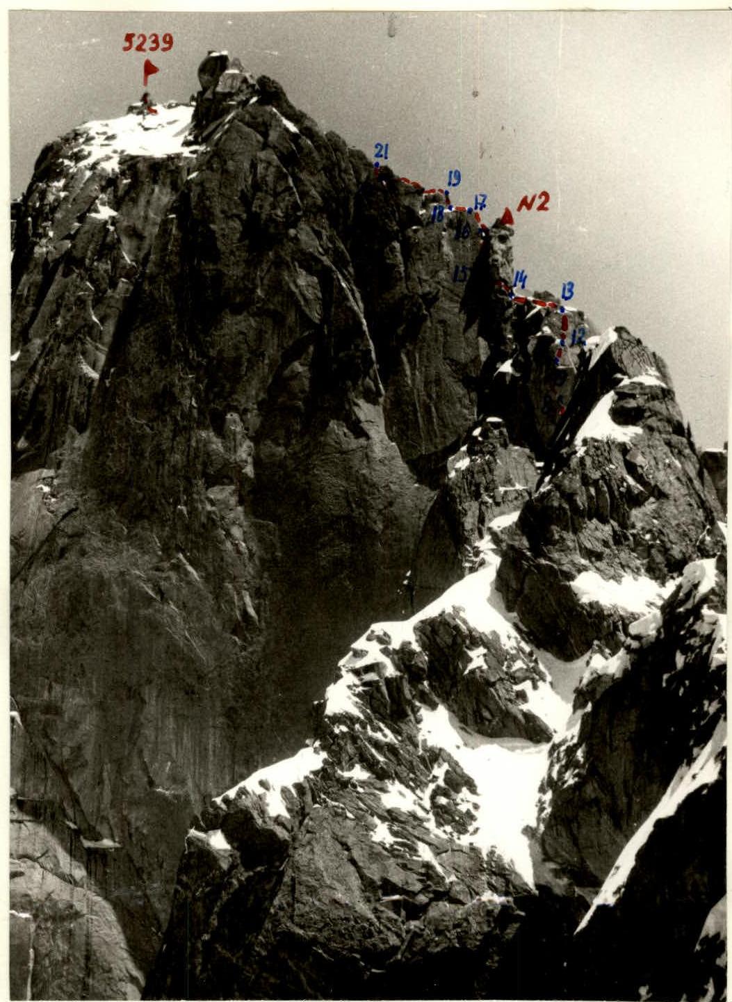
Photo #5. Technical photograph of the route. Taken from peak 3. Blok.
- Lens: I-26M (F=52)
- Distance: 1 km
- Height: 4800 m
- Date: July 22, 1983
- Time: 14:00