Passport
I. Technical Class
-
Pamir-Alay, Turkestan Range, Ak-Su gorge
-
Peak Blok A., 5239 m, via the Southwest Ridge (N. Petrichenko's route)
-
Category 5B difficulty
-
Route characteristics:
- Elevation gain: 790 m
- Length: 990 m
- Length of sections with 5th-6th difficulty category: 400 m
- Average slope of the route: 55°
- Average slope of the icy part: 50° (4450–4850 m)
- Average slope of the main rocky part: 72° (4850–5105 m)
-
Pitons used:
rock 47/10, chocks 71/9, ice screws 8
-
Team's climbing hours: 23, days: 3
-
Overnights: 1st bivouac 2nd bivouac
-
Team leader: Yuri Alexandrovich Gaydamakin — 1st sports category
Team members:
- Georgy Konstantinovich Bogomolov — 1st sports category
- Nikolai Andreevich Smotrov — Candidate for Master of Sports
- Yuri Nikolaevich Savostin — 1st sports category
-
Coach: Vladimir Alekseevich Gonchar
-
Start of the route: July 11, 1989
Summit: July 12, 1989
Return: July 13, 1989
-
Voronezh Regional Sports Club of the All-Union Trade Union Sports Society

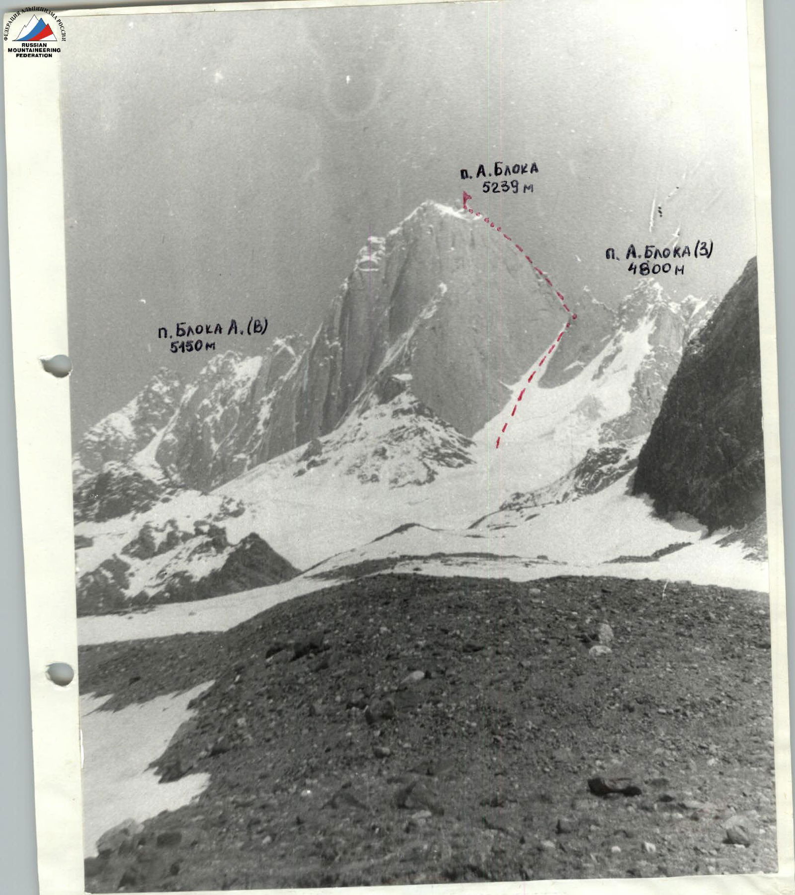
General view of the summit. Taken from the eastern ridge of peak 4100. Date: June 26, 1989. Time: 11:00. Lens: T-43/F=40 mm. Distance: 1.5 km. Shooting point #1. Elevation 3800 m. Routes:
- N. Petrichenko's route taken by the team
- S. Efimov's route
- K. Valiev's route
Photopanorama of the area. Taken from under the wall of Peak M. Iskander. Date: June 30, 1989. Time: 20:00. Lens: T-43/F=40. Distance: 4 km. Shooting point #2. Elevation 3400 m.
Team's Tactical Actions
During the ascent to Peak A. Blok, the team deviated from the tactical plan as follows:
- On July 11, the team traversed the snow-ice couloir (R0–R5) 1.5 hours faster than planned, as the upper part of the couloir (R3–R5) was heavily snowed, and belays were made using ice axes.
- On the same day, the team failed to process 2-3 ropes of the "key" section as per the tactical plan, due to being delayed by a group from Dnipropetrovsk, which vacated the wall only late in the evening. This delay forced the team to "catch up" on lost time the next day, starting the ascent up the complex wall of the "key" without prior processing.
The bivouac sites were at planned safe locations.
On the first day of the ascent, July 11, 1989, the rope team Smotrov—Gaydamakin worked ahead (R0–R5). Belays were made using ice axes. The upper part of the snow-ice couloir was traversed with belays using ice screws (R4–R5). A bivouac was set up upon reaching the Southwest Ridge.
On the second day, July 12, 1989, the rope team Bogomolov—Savostin worked first (R5–R16). Belay points on these sections were inconvenient, mostly hanging. After passing the "key," the rope team Gaydamakin—Smotrov went first (R16–R26). Belay points were generally convenient. Movement was mostly simultaneous, with the first rope team leaving belay points for the second. At 19:20, the team reached the summit and by 22:00 descended to the planned bivouac on the "Gheelovka syra" gendarme.
On the third day, July 13, 1989, the team continued the descent according to the tactical plan.
The team successfully navigated the technically complex sections R6–R13 and R15–R16, skillfully utilizing a wide range of equipment. Radio communication worked regularly without interruptions.
The team returned to the base camp on July 13, 1989, at 17:00.
Food and Fuel Table
| 1. Rusks | 1.5 kg |
| 2. Chicken soups | 0.2 kg |
| 3. Boiled meat | 1.5 kg |
| 4. Condensed milk | 0.9 kg |
| 5. Buckwheat | 0.4 kg |
| 6. Semolina | 0.2 kg |
| 7. Lard | 0.5 kg |
| 8. Sugar | 0.4 kg |
| 9. Sweets | 0.8 kg |
| 10. Honey with nuts | 1.0 kg |
| 11. Black tea | 0.1 kg |
| 12. Dried fruits (raisins, apricots) | 0.8 kg |
| 13. Chocolate | 0.4 kg |
| Total: | 8.7 kg |
| 14. Gasoline (with packaging) | 2.2 kg |
| Total weight: | 10.9 kg |
| Total weight of team's backpacks (with gear): | 45.2 kg |
Route Diagram in Symbols
| Pitons | ROCK | CHOCK | ICE | |
|---|---|---|---|---|
| R23 | ||||
| 2 | 3 | – | IV–30 m 50° R22 | |
| – | 6 | – | IV 80 m 50° R21 | |
| – | 4 | – | V–10 m 80° R20 | |
| – | 3 | – | IV 40 m 50° R19 | |
| – | 1 | – | IV 10 m 70° R18 | |
| – | – | – | Gendarme "Gheelovka syra" II 30 m 30° R17 | |
| 4 | – | – | V 30 m 80° R16 (July 12, 1989, 5080 m) | |
| 3 | 8 | – | V+ 40 m 80° R15 | |
| – | 1 | – | IV 20 m 65° R14 | |
| – | – | – | II 40 m 35° R13 | |
| 8 | 4/2 | – | V+ 40 m 80° R12 | |
| – | 2 | – | V 6 m 90° R11 | |
| 5/4 | 1/2 | – | A3 VI 20 m 90° R10 | |
| 4/2 | – | – | A3 VI 10 m 90° R9 | |
| 6 | 3 | – | V+ 30 m 70° R8 | |
| 1/1 | 1 | – | A2 VI 6 m 95° R7 | |
| 1/1 | 6/3 | – | A3 VI 10 m 90° R6 | |
| III–IV ~200 m 50° R25 | ||||
| V+ 5 m 90° R24 | ||||
| V–20 m 90° R23 |
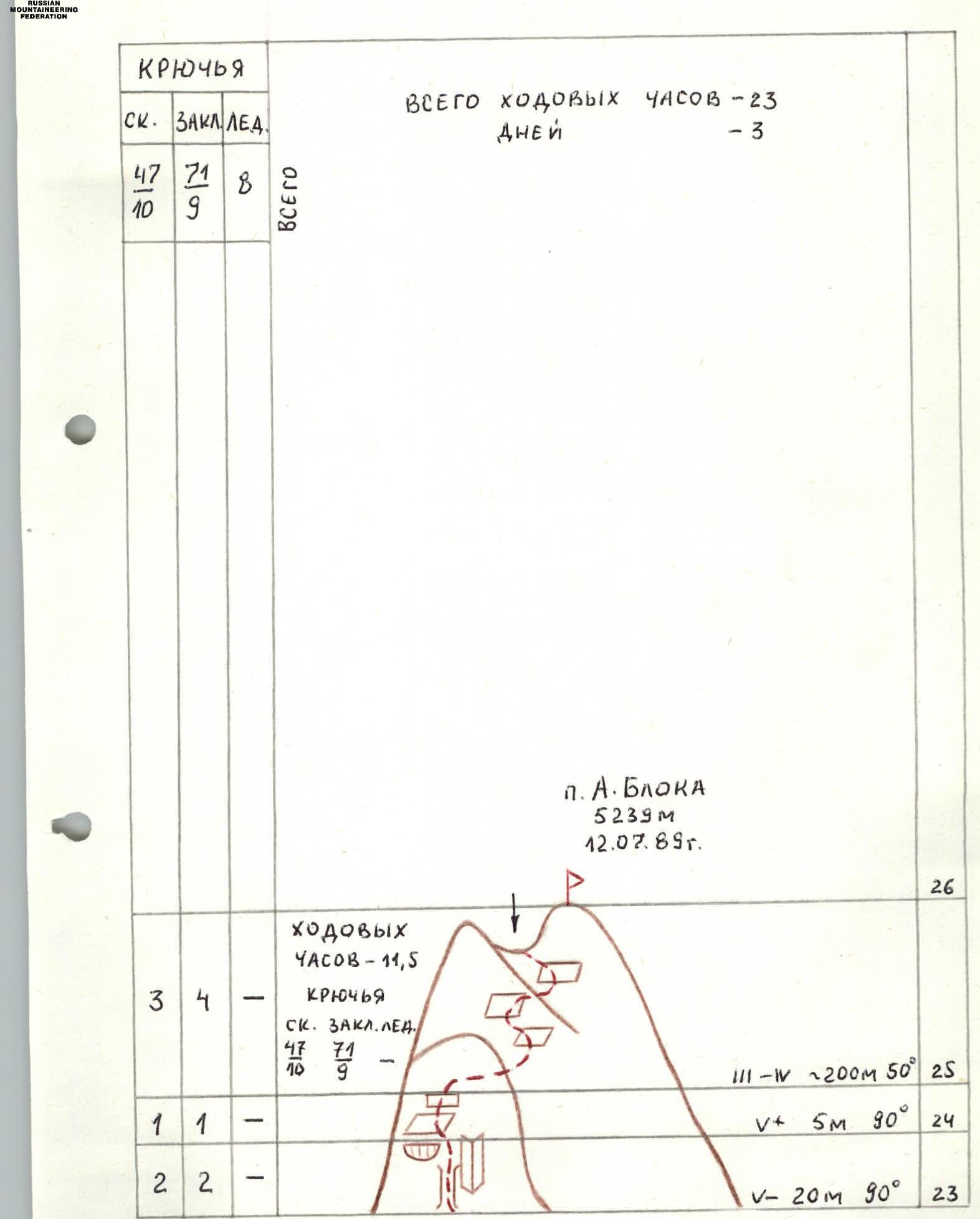
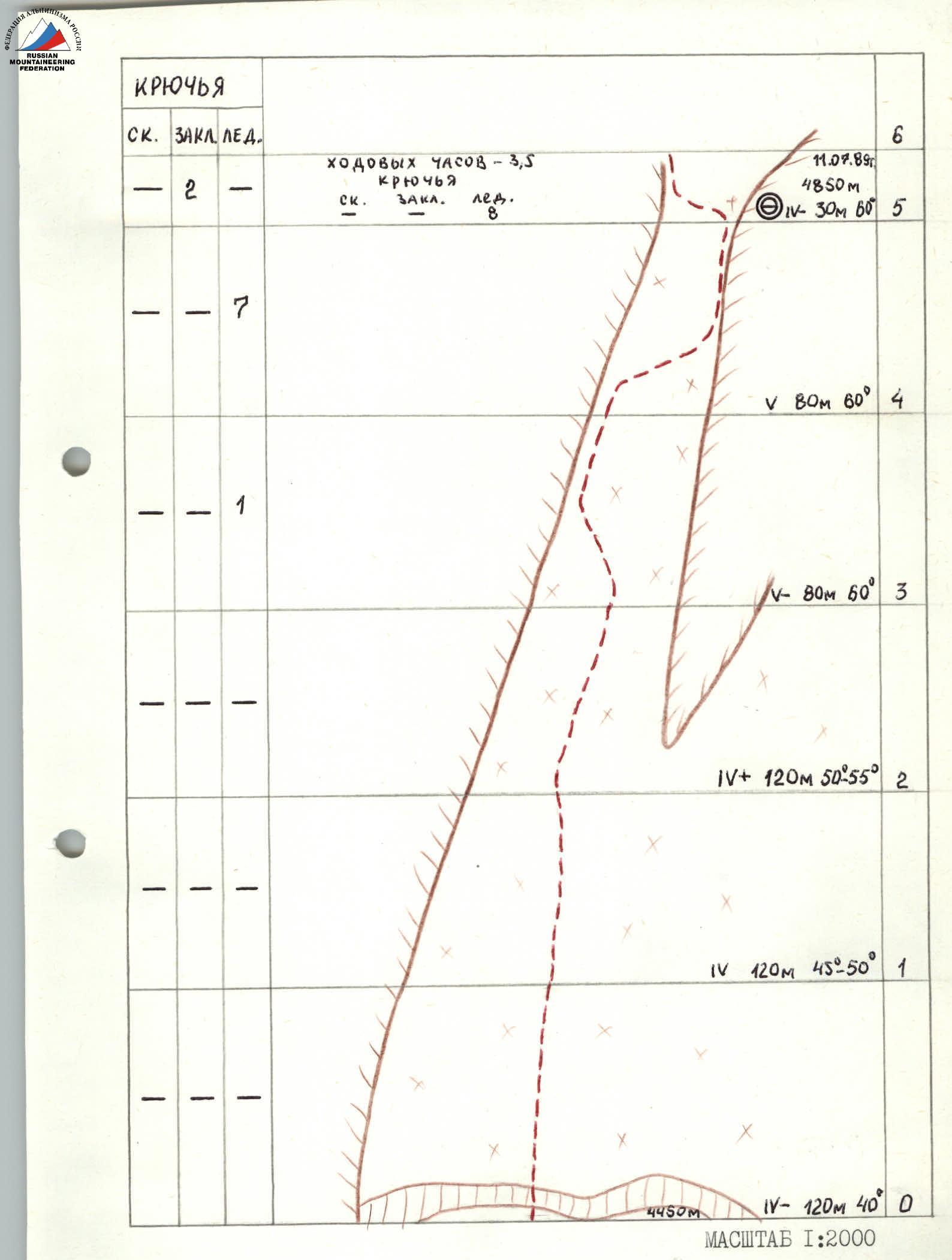
Route Description by Sections
R0–R5. Snow-ice couloir with increasing steepness, approximately 400 m long. Ice screws or ice axes are necessary for traversing the upper part of the couloir.
R5–R6. Steep ridged ridge.
R6–R7. Internal corner-chimney with ice remnants; ladders are required. To the right, a characteristic cornices with a nearly horizontal "ceiling".
R7–R8. Internal corner-chimney, traversed using artificial aids and ladders.
R8–R9. Narrow crevice in the rusty wall, ending at an internal corner under a large cornices (with an enormous icicle inside!). Large chocks fit well.
R9–R10. Wall to the right of the crevice, traversed on ladders; petal pitons are necessary. The section ends on a narrow ledge.
R10–R11. Rightward-upward along a crack using artificial aids and ladders. Petal pitons are necessary.
R11–R12. Exit from under the cornices via a chimney, climbing.
R12–R13. Wall with block structure, traversed by free climbing.
R13–R14. Simple broad ridge leading to the "Gheelovka syra" gendarme with characteristic cavities.
R14–R15. Internal corner leading from under the base of the "Gheelovka syra" gendarme to a rocky slab-plate under an overhang, which must be traversed crawling.
R15–R16. Difficult internal corner in the northern wall of the gendarme, leading to a large flat area on top of the "Gheelovka syra" gendarme. Medium and large chocks fit well.
R16–R17. Sheer edge; the southern side has a system of inclined cracks. Climb along these to an inclined platform.
R17–R20. Along the left side of the ridge through a small wall to the next gendarme.
R20–R21. Traverse the gendarme on the left along a ledge, exiting into a narrow gap in the ridge via an internal corner.
R21–R22. Traverse along the right side of the ridge via a system of ledges, cracks, and flakes under a large gendarme with characteristic facets and edges.
R22–R23. Internal corner-couloir with snow and ice, transitioning into a difficult internal corner in the gendarme's wall (few holds).
R23–R24. Pass behind the internal corner and climb up a chimney formed by a wall and a fragment, under an icy wall.
R24–R25. Difficult icy wall. Section R23–R25 can be impassable with significant snow and ice. In this case, the ascent to the gendarme should be made via the internal corner.
R25–R26. Along a system of ledges and scree, interspersed with small walls, generally heading rightward, to a cairn on a narrow col between two gendarmes; the right one (with a sharp top) is the summit.
Descent is via the ascent route.
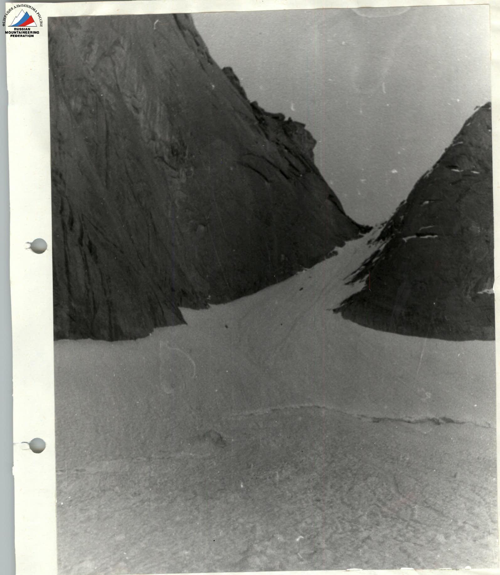
Photo I. Section R0–R5. Snow-ice couloir. Taken on July 11, 1989, at 7:50.