Ascent Log
- Class — technical
- Ascent area — Pamir-Alay, Turkestan Ridge, Ak-Su gorge
- Ascent object — Peak "5090" (Admiralteets) via NE wall, V grade
- Difficulty category — 5B
- Height difference — 790 m, route length — 976 m, including U–UІ — 367 m UІ — 65 m Average steepness of the route — 55°. Average steepness of the main section of the route (4500–4990) — 59°.
- Pitons driven: rock 35/3; chocks 68/11, ice screws 41/–
- Number of climbing hours — 20
- Number of nights on the route — 1 comfortable overnight stays in tents — 1
- Team composition:
Leader — Chistoserov A.B. — 1st sports category
Participants:
- Shestopalov P.I. — 1st sports category
- Kolesov A.P. — 1st sports category
- Solomein V.K. — 1st sports category candidate
- Team coaches:
- Lebedikhin A.V. — Master of Sports of the USSR
- Chiyanov N.E. — Candidate Master of Sports Releasing coach —
- Departure to the route — August 17, 1988 Summit reached — August 18, 1988 Return to base camp — August 18, 1988
Team's Tactical Actions
According to the tactical plan, on August 16, the team left the base camp and approached the tongue of the Ak-Su glacier for an overnight stay. On August 17, they departed from the assault camp at 7:00 and were under the start of the route by 8:00. They traversed the ice in autonomous rope teams, using ice screws for protection. The first rope team, Kolesov–Shestopalov, worked first. By 11:00, they reached the rock section of the route. Shestopalov worked the R2–R12 sections first.
During the ascent, the team's tactical actions were as follows: The first climber moved unloaded (carrying only personal items in their backpack) on a double rope, securing one rope as a handrail. The others followed using the handrail with top or bottom protection. The combination of ice and rock kept the team on high alert. Many rock sections were iced over, requiring crampons and ice axes, while longer rock sections could be traversed in galoshes. Initially, the route passed through a zone of broken rocks, so typically only one person was on the handrail at a time, despite intermediate anchors being in place. On particularly broken rocks, when the route went vertically, all team members had to wait in line and closely follow the first climber.
Detailed preparation of the route allowed the team to stick to the tactical plan precisely. On the first day, they reached the planned overnight stay by 18:30. After resting, Kolesov and Shestopalov processed three more rope lengths until 21:00.
On the second day, departing from the overnight stay at 8:00 and passing the processed ropes, the group continued their ascent. Kolesov worked first. Ice and snow on the rocks forced the team to wear crampons. The presence of a tent and a comfortable overnight stay location allowed the team to recover well after the first day's ascent, maintaining their previous pace. The team reached the summit at 14:00.
At 14:30, the group began their descent from the summit via rappel loops left by previous climbers. By 21:00, the group returned to the base camp.
The nutrition regimen included hot meals in the morning and evening (using autoclaves) and snacks during the day. The daily food ration was 500 g per person.
Radio communication with the base camp via the "Karat" radio station was stable. 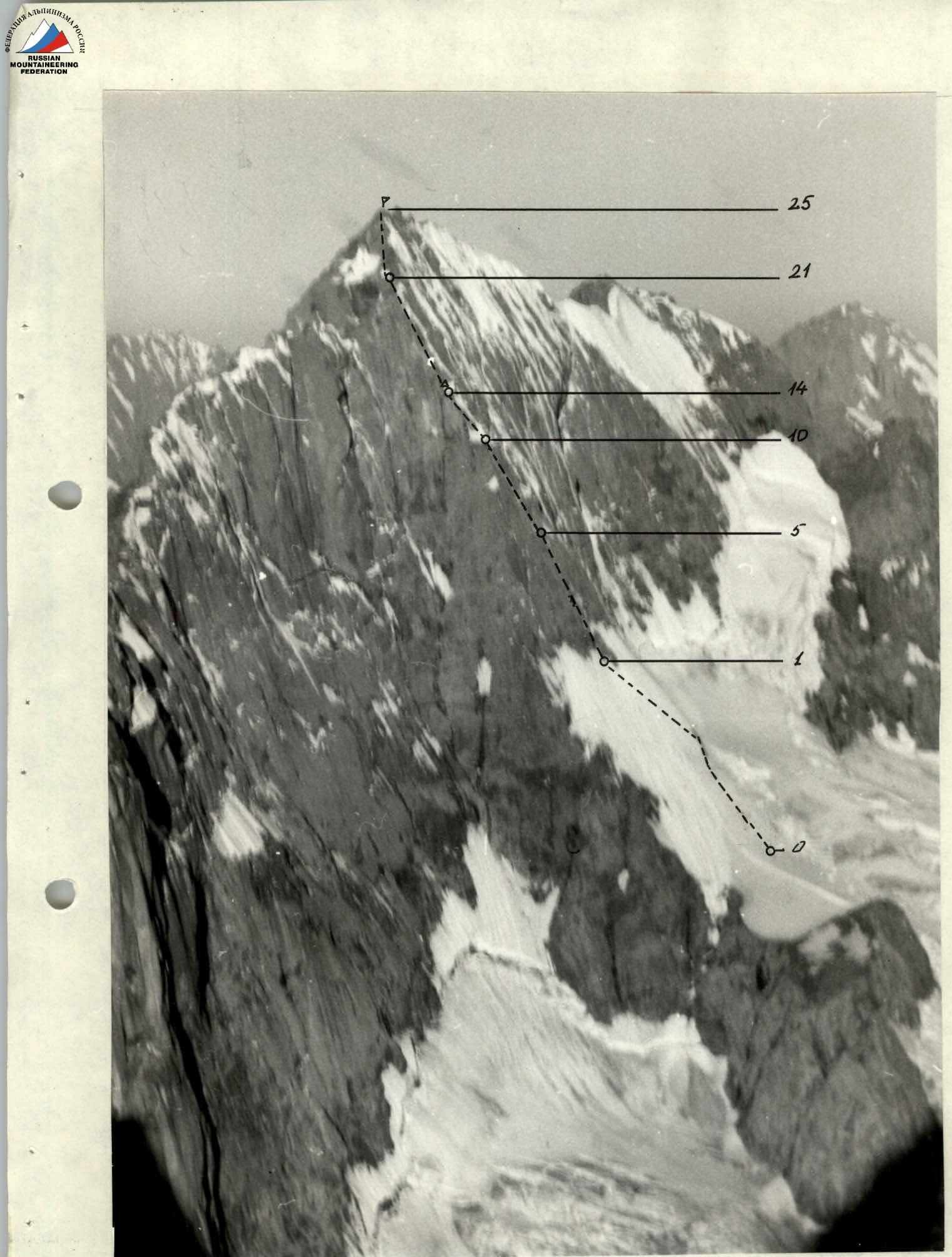
Photo 3. Profile of the left wall. Taken from v. A. Blok on August 9, 1988.
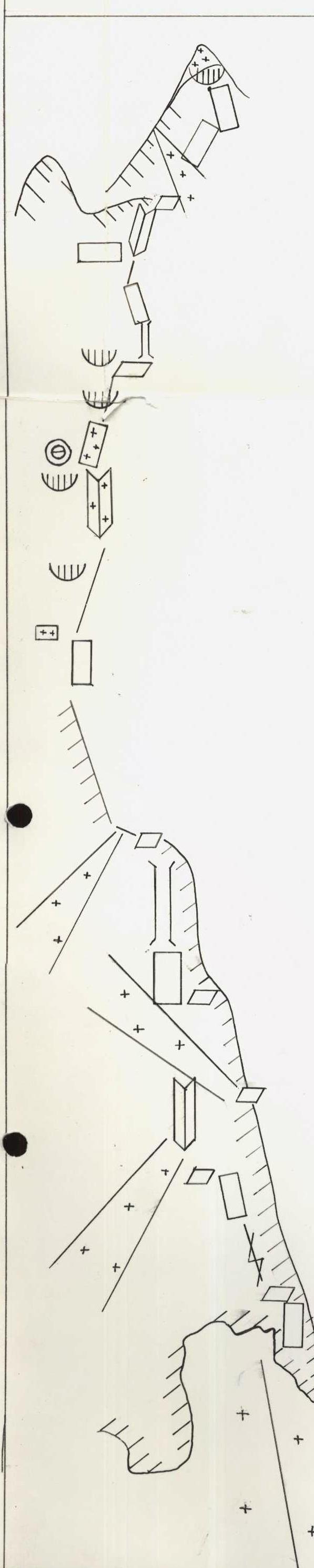
Route Diagram in UIAA Symbols
| SECTION | STEEPNESS | LENGTH | DIFFICULTY CATEGORY | PITS DRIVEN (rock / chocks / ice screws) |
|---|---|---|---|---|
| R25 | 20° | 10 m | 2 | 1 / 1 / – |
| R24 | 95° | 6 m | 5+2MA2 | 1 / 2 / – |
| R23 | 60° | 30 m | 3 | 1 / 1 / 1 |
| R22 | 50° | 40 m | 3 | 1 / 2 / – |
| R21 | 20° | 30 m | 2 | 1 / – / 1 |
| R20 | 45° | 30 m | 4 | 1 / 3 / – |
| R19 | 45° | 20 m | 3 | – / – / 4 |
| R18 | 65° | 30 m | 5 | 1 / 4 / – |
| R17 | 80° | 10 m | 51,3м А2 | 2 / 5/1 / – |
| R16 | 50° | 10 m | 4 | 2 / 1 / – |
| R15 | 70° | 50 m | 5,5м А2 | 3/1 / 6/3 / – |
| R14 | 60° | 20 m | 5 | 1 / 2 / 1 |
| R13 | 60° | 35 m | 5+ | 1 / 3 / 3 |
| R12 | 50° | 80 m | 3 | – / – / 5 |
| R11 | 55° | 40 m | 5 | 2 / 2 / 3 |
| R10 | 50° | 80 m | 4 | 1 / 1 / 4 |
| R9 | 15° | 20 m | 2 | – / – / – |
| R8 | 90° | 25 m | 51,5м А2 | 5/1 / 8/1 / – |
| R7 | 80° | 30 m | 6,5м А2 | 3 / 6/3 / – |
| R6 | 50° | 40 m | 4 | 1 / 1 / 3 |
| R5 | 60° | 30 m | 5 | 2 / 5 / – |
| R4 | 70° | 30 m | 5+,5м А1 | 3 / 7/3 / – |
| R3 | 60° | 30 m | 4 | 2 / 4 / 1 |
| R2 | 80° | 25 m | 5 | 1 / 5 / – |
| R1 | 50° | 220 m | 4 | – / – / 15 |
Route Description by Sections
R0–R1. Ice ridge covered with 10–20 cm of snow, icy in the upper third. The left part is sunlit after 9:00, avalanche hazard. Traverse in crampons.
R2. Steep rock wall with limited holds, traverse in galoshes.
R3. Chimney filled with ice, traverse using ice axes.
R4. Steep smooth wall with limited holds. Direct ascent is impossible due to three complex cornices; detour to the right.
R5. Inner corner with ice accretion. Rocks are wet, with many loose stones. Traverse requires great caution. At the end of the section, a snowy ledge allows for a single tent.
R6. Steep snow-ice slope, traverse in crampons. An alternative route follows a rocky ridge, but the rocks are heavily destroyed.
R7. Very complex smooth monolithic slab with an overhanging section. Traverse in galoshes, using artificial aids. Traverse via handrails is challenging.
R8. Wet, icy, and steep chimney. Artificial aids.
R9. Rocky ledge covered with snow and ice, with many loose stones. Suitable for an overnight stay.
R10. Steep ice slope. Crampons and ice axes required; protection via ice screws. An alternative route follows a rocky ridge to the left, weather permitting.
R11. Snowy rocks with ice accretion. Further movement along the couloir is hazardous due to falling stones from overhanging cornices. Traverse in crampons; intermediate protection is limited, and climbing is strenuous.
R12. Large ledge, planned overnight stay location. Further ascent follows a snow-ice slope with calcareous ice. In places, ice lies on rocky slabs. Protection via ice screws.
R13. Steep, icy inner corner. Ice is accretionary and brittle. Traverse in crampons, using ice axes. A "carrot" is driven in the middle of the corner.
R14. Snowy rock ledge. Protection via rock pitons.
R15. Very steep, sharp rock ridge. Traverse in galoshes on the left side. Artificial aids.
R16. Ledge. Caution: loose stones.
R17. Wet chimney. Rocks are smooth; traverse in galoshes, using artificial aids.
R18. Steep, smooth slab. Traverse in galoshes with artificial aids, leading to a balcony for 3–4 people.
R19. Section leads to the eastern ridge.
R20. Inner corner; caution: loose stones.
R21. Scree ledge, suitable for a comfortable bivouac.
R22. Scree ledges.
R23. Steep, smooth slab, ending in a cornice.
R24. Cornice of the summit tower.
Descent from the summit follows the southern ridge. Initially, 60 m down a snowy couloir to rocky outcrops. From here, an 80 m rappel down, followed by a descent along the southern ridge to a table-like gendarme. From here, the descent continues via steep, wet rock faces.
Total descent length — 320 m. The descent ends on a broad snow slope, easily descending into the Kara-Su gorge.