
Ascent Passport
- Class of wall ascents.
- Pamir-Alay, Turkestan Ridge, Myn-Teke gorge.
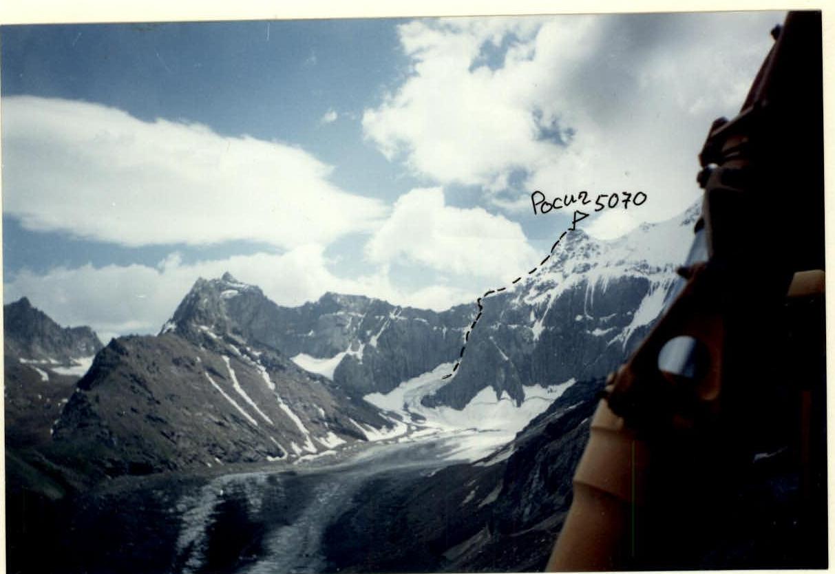
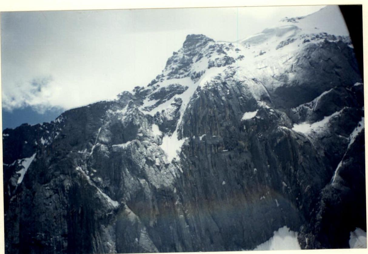
- Peak 5070 (Rossich) via the north-eastern counterfort of the north wall.
- The route is approximately category 5B, combined, first ascent.
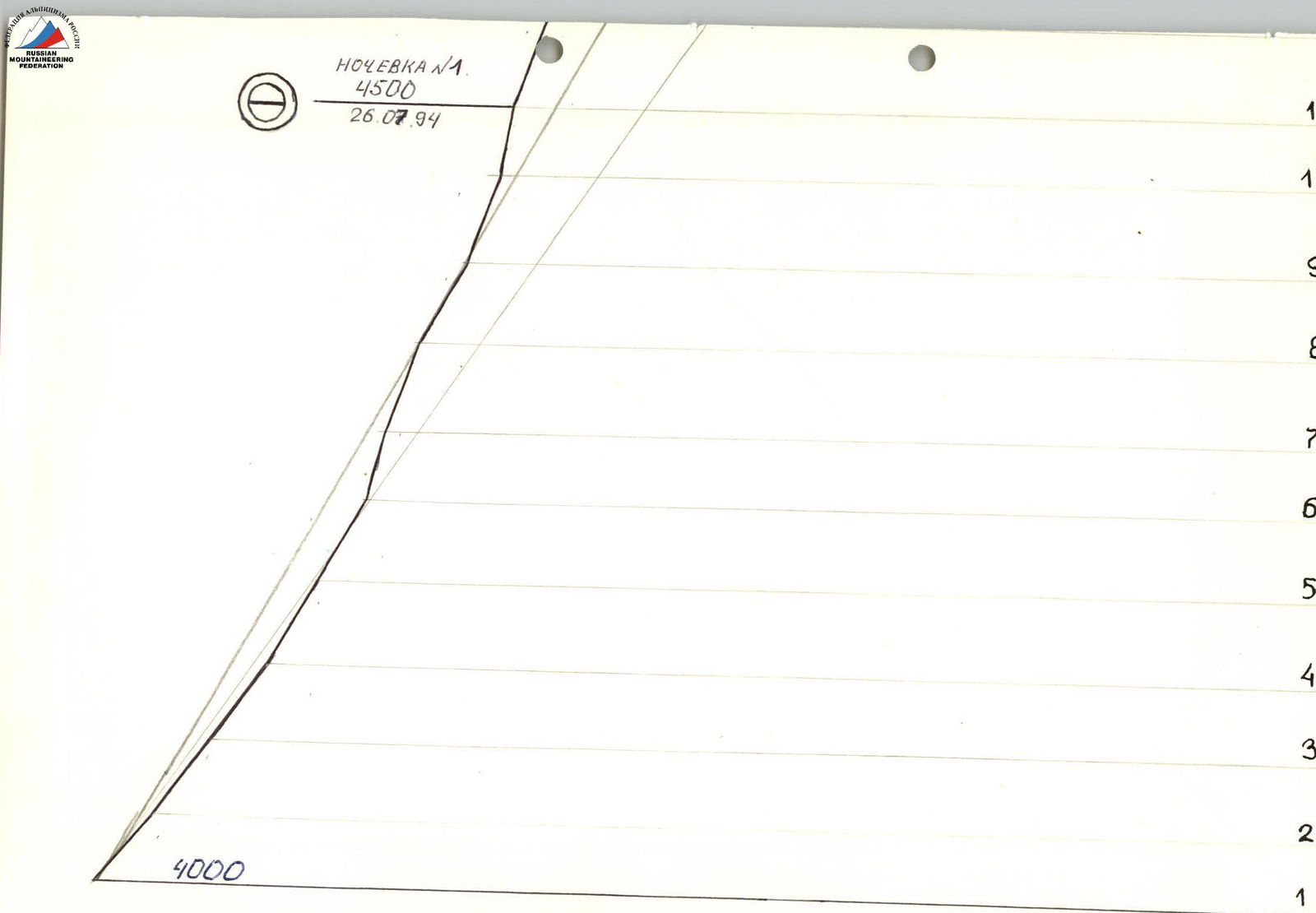
- Height difference: 1070 m. Length: 900 m. Length of sections with 5–6 category difficulty: 590 m, including 6 category difficulty: 100 m. Average steepness of the route: 55°. Average steepness of the wall part of the route: 65°.
- Pitons driven:
| Rock | Sky Hooks | Nuts |
|---|---|---|
| 84 | 55 | |
| 4 | 3 |
- Climbing hours: 26 hours, days: 3.
- Overnights: 1 lying on a rock platform, 2 lying on a ridge.
- Captain: Alexey Vazhlaev (1st sports category). Team members: – Sergey Popov (1st sports category). – Alexander Katerinin (1st sports category). – Valery Rogozin (1st sports category).
- Coach: Gennady Kirievsky (Master of Sports).
- Departure to the route: July 26, 1994. Summit: July 27, 1994. Return: July 28, 1994.
- Magnitogorsk Alpine Club of Magnitogorsk Mining and Metallurgical Institute.
Brief Overview of the Ascent Area
From the Turkestan Ridge, separating the Dzhiptyk and Karatu gorges, a high massive mountain chain stretches to the northwest, conditionally called the Mintake Ridge. Peak 5070 is located in this ridge.
Peak 5070 m is a powerful rocky bastion stretching from peak 4650 m (OSS summit) to peak 5100 m (Sofia summit), with a length of more than 2.5 km, resembling a horseshoe, at the foot of which the Mintéke glacier originates. The rocky bastion consists of:
- granites
- siliceous schists.
The Mintéke gorge is small in size, and therefore the approaches to the routes do not take much time. The climate of the region is moderately continental.
Administratively, the summit is located in the Batken district of the Osh region of Kyrgyzstan.
The approach to Peak 5070 m (Rosich) from the base camp, located in the green zone 300 m from the end of the Mintéke glacier at an altitude of 3300 m, takes 2–3 hours.
The ascent area can be reached from the settlement of Varukh (Tajikistan). The path includes:
- A car ride along the Kshémish river to the tributary of the Chelsli river and further along the Chelsli gorge to the dairy farm (20 km).
- Then — on a pack trail over the Dzhiptyk pass to the meteorological station house (22 km).
- Further — along the river downstream on the right side of the Dzhiptyk river to the bridge.
- From the bridge — the trail steeply winds up and then traverses the slope to the right, smoothly leading to the Kugandy pass.
- From the pass, a view opens up to the Mintéke and Karatura gorges.
- From the Kugandy pass, the trail, gradually gaining height, leads to the beginning of the Mintake glacier.
700 m before the beginning of the glacier, the base camp is conveniently located on the left bank of the Mintéke river. From the meteorological station house to the base camp — 30 km.
Tactical Actions of the Team
The tactical plan of the team was designed for the first ascent of the counterfort of the northern wall of Peak 5070 ("Rosich") according to two options depending on weather conditions. The main option provided for passing the route with two overnight stays. Unstable weather in the area forced consideration of an additional day for processing in the second option.
To ensure safety, the ascent initially planned for the earlier passage of the bergschrund and couloir by the rope team Popov S.V. — Vazhlaev A.Yu.
For an even workload distribution among the team members during the ascent, the tactical plan provided for the work of each team member: section R0–R8 — Popov S.V.; R8–R15 — Vazhlaev A.Yu.; R15–R20 — Katerinin A.; R20–R26 — Rogozin V.G.
During the first day of work, 11 ropes were passed.
On July 7, starting at 8:00, the group ascended to the ridge and continued moving to the summit, which they reached at 16:00.
On the descent from the summit, the team was forced to stop for the night on the ridge due to worsening weather at 18:00.
On the third day of the ascent, in bad weather conditions (snow), the team continued the descent from the summit to the base camp. The team returned to the base camp at 14:00.
For safety, the first climber worked on a double rope (one UIAA), the other team members ascended on fixed ropes with top rope belay. All belay points were organized on three points (a combination of two pitons and nuts). The quick passage of the route was facilitated by:
- free climbing
- partial use of artificial technical aids (IT).
Nutrition during the ascent days was two meals a day (morning and evening) using high-calorie rations and a drink in flasks. An autoclave was used for cooking. There were no accidents or injuries to participants. Communication with the base camp was carried out using a "Kaktus" radio station.
| Section | Category of Difficulty | Length, m | Steepness, ° | Rock Pitons | Nuts |
|---|---|---|---|---|---|
| R7–R8 | V | 40 | 60 | 3 | 3 |
| R6–R7 | V | 40 | 70 | 2 | 4 |
| R5–R6 | VI | 30 | 75 | 10 | 4 |
| R4–R5 | V | 40 | 50 | 5 | 7 |
| R3–R4 | V | 40 | 60 | 6 | 2 |
| R2–R3 | IV–V | 40 | 55 | 7 | 3 |
| R1–R2 | V | 40 | 55 | 5 | 6 |
| R0–R1 | IV | 40 | 50 | 6 | 4 |
| Section | Category of Difficulty | Length, m | Steepness, ° | Rock Pitons | Nuts |
|---|---|---|---|---|---|
| R16–R17 | IV–V | 300 | 45 | ||
| R15–R16 | IV–V | 40 | 45 | 10 | |
| R14–R15 | IV | 40 | 40 | 4 | 2 |
| R13–R14 | IV | 40 | 55 | 3 | 3 |
| R12–R13 | IV | 80 | 60 | 10 | 8 |
| R11–R12 | V | 40 | 65 | 2 | 3 |
| R10–R11 | V | 40 | 70 | 6 | 1 |
| R9–R10 | V/A | 30 | 80 | 8/4 | 7/3 |
| R8–R9 | V⁺ | 40 | 70 | 5 | 2 |
Route Description by Sections
R0–R1 — destroyed wall. Rockfall hazard. R1–R2 — monolithic wall. R2–R3 — smoothed internal corner. R3–R4 — chimney, free climbing. R4–R6 — smoothed walls. R6–R7 — internal corner, free climbing. R7–R9 — monolithic walls, few holds, overnight stay for the whole team lying down. R9–R10 — smoothed wall, passed using artificial technical aids (IT). R10–R11 — smoothed walls. R11–R12 — chimney passed by free climbing. R12–R14 — destroyed walls. R14–R15 — traverse of inclined destroyed slabs, snow and ice. R15–R16 — chimney, passage complicated by snow, exit to the ridge. R16 — overnight stay for the whole team lying down. R16–R17 — snow and ice ridge leading to the summit, possible snow avalanches.